Typhoon Tip
-
Posts
44,833 -
Joined
-
Last visited
Content Type
Profiles
Blogs
Forums
American Weather
Media Demo
Store
Gallery
Everything posted by Typhoon Tip
-
December 2024 - Best look to an early December pattern in many a year!
Typhoon Tip replied to FXWX's topic in New England
just as an after thought you know, i am always leery of those facets when we enter favorable patterns. 'how are we going to end up paying taxes on this shit this time' with an eye rolling. we started getting charlie browned by them about .. 9 years ago, but at around that time, my memory was like, 'hey ..this has been happening for a lot longer now that i think about it' -
December 2024 - Best look to an early December pattern in many a year!
Typhoon Tip replied to FXWX's topic in New England
the colder deltas are in the east. the pacific injected s/w are riding along a very balanced medium, having traversed the entire pacific domain - which reaches to 55 N out there or whatever it is... s/w's enter the western continent, which by virtue of proximity to the pac is not appreciably different. however, by 100W the flow is ( mt torque ) instructed to tip s... the s/w goes s and that is intrinsically a nva as it rides down the negative slope of the l/w. compounding this with the fact that it is colder at 45 N over the continent, the flow is also more compressed: the former aspect has always been there; the latter compression has been growing as the ambient gradient between s canada and florida ( rough metric ) is more sloped. the whole luck thing for me... it's like going to a football game where a c+ team is trying to win against an a- team... luck can't cover the gap as well as if an a- team is playing an a- team. you could almost say that the a c+ team was lucky the score was ever close. -
December 2024 - Best look to an early December pattern in many a year!
Typhoon Tip replied to FXWX's topic in New England
those backward sloping vorticity fields in troughs are becoming more and more familiar since the late 1990s. what we're observing now in Brook's post above is evidence of the same aspect, and it is caused by a plague of speed saturation in the mid latitude, ambient flow. it's going on because the boreal heights of winters' onsets are compressing against what is ( most likely ) cc attributed elevated/residual heights at lower latitudes. this creates large gradient that is mechanically expressed as a faster geogstrophic wind. as an aside, a hint to this reality is that the glaam scalar values have been lower over the last ( in particular 10 to 20 years ). why? the sub-tropical jets are weakening, and the polar jets are becoming the stronger and more effective momentum transfer mechanisms. subtropical jets have a bigger radius variable in the momentum equations, ( radius x mass x velocity ), because lower latitudes are closer to the axis of earth's rotation. by mid latitudes, the angle is 45 deg and ... i think the above becomes trig function X mass X velocity ... which yields a lower glaam. now that heads are aching ... my work here is complete. that means that as the wind maxes are pushed N, the glaam goes mathematically down, because higher latitudes winds have a bigger axis of rotation angle. this is proof of what i have arguing over the last 15 years, when the quickening wind was being observed ... not just by me wrt to weather chart and model data, but by countless reports of jet flight historically low flight times along west to east routes, at mid and high latitudes over that same time span. i'd also argue that perturbation (system event) translation speeds have also been faster too, but etc.. s/w has a wind maximum of 110 kts ( say ...). in 1970, the ambient wind outside of the the s/w region is only 50 or so knots. that means that the s/w has a delta of 60 kts. in 2024, a 110 kt s/w wind max has a delta against an already elevated wind ambience of of 70 or 80 or so ... so the delta is 30. that's the same as saying 30 kts of wind mechanics are being absorbed; that sloping backward picture is the manifestation of that in illustration. i keep seeing that over and over again. a saga when the distant telecon spreads begin signaling a negative polar fields with favorable pnap across the east pac/continent ... then, it starts to show up in the operational runs ( usually with 300+ hour perfectly sculpted bombs )...but what happens is a lot of the absorption shit. what's also kind of interesting is that we also are increasing the intervals of these occurrence, because in general ... the pattern residences are shorter leased by proxy of the unstable resonance. so, the storm frequency is actually kind of the same, even though the above. -
how was +aam a pattern driver? i may also not be exposed to/understanding the discussion's roots ... just sayn' -aam is consistent with blocking patterns - referred at times to 'meridian flow' types. hint, -epo/-ao/-nao/+pna are meridian flow types +aam is consistent with less blocking patterns - referred at times to 'zonal flow' types. so i'm not seeing how a the last two weeks of -wpo/-epo, episodic -nao, with a +pna means a +aam is driving these to occur. first of all, the aam doesn't drive anything. that is scalar of the integral for angular momentum, which in it's simplest mathematical form, is provided by, radius X mass X velocity when the flow is flat/zonal/longitudinal, the radius term becomes very large, and the product of the above multiplication is thus also bigger --> +aam the forecast of the aam off model guidance is a forecast of a scalar value out in time. i get it that the aam is technically positive as a global integral - but all that means is that in the absence of recent -epo/-wpo and nao and so forth, the positive glaam would have just been even larger. there's a relativistic scoping that has to be considered.
-
December 2024 - Best look to an early December pattern in many a year!
Typhoon Tip replied to FXWX's topic in New England
17 coldest night so far this season -
December 2024 - Best look to an early December pattern in many a year!
Typhoon Tip replied to FXWX's topic in New England
This oughta tune up the posters good and proper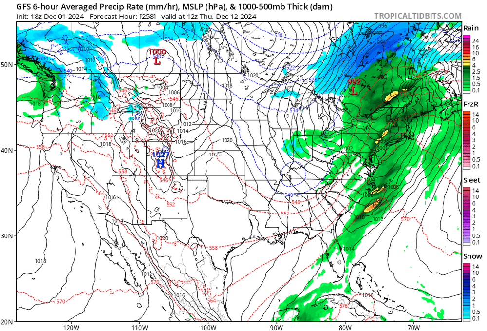
-
December 2024 - Best look to an early December pattern in many a year!
Typhoon Tip replied to FXWX's topic in New England
it's a specter that's looming. yup. this notion of getting through this interval with a huge underachievement relative to indicators - perhaps even nothing - has occurred to me. seeing a repeating behavior so far, but we'll see. just trying to bring some objectivity to the table. i'm noticing that the we have immediately in tandem with this, started this wave velocity problem again, the same as the last decade's worth of winters... maybe it's just the models, but it seems any attempt to bring cold into the 45th parallel immediately results in negative interference between s/w identity vs the basal gradient being too much. -
December 2024 - Best look to an early December pattern in many a year!
Typhoon Tip replied to FXWX's topic in New England
the mjo appears to have trouble propagating beyond phase 4. it is rather abruptly collapsing in the individual ens means in the rmm. while that is occurring, wpo is also tending to correct downward as the outer edge/emergent extended materializes over the temporal horizon. it's neutral out there around 300+hrs, but it's been failing to move closer in time along the mean curve... so long as all this is the case, current mjo outlook is in conflict with the wpo forcing, wrt the mid and upper latitudes ... the 'tendency' to -d(wpo), and the nearer turn -wpo phase state, together suggests the real hemispheric state for me however, those opposing forces are likely to enhance model variability in the mid month period, as far as determining the general pattern motif in that time. -
December 2024 - Best look to an early December pattern in many a year!
Typhoon Tip replied to FXWX's topic in New England
i saw this meme the other day that was eye rollingly funny... it was something like only in amerca do people trample over one another is a psychopathic rage of material hollowness a day after celebrating, in peace, a holiday to be Thankful for what they have. ...although, some of the households in here ... you know, you wonder if they are a delicious pressure cooker socio-dynamic functionality state, where time outs spent with social media serve as a release valve... lol -
December 2024 - Best look to an early December pattern in many a year!
Typhoon Tip replied to FXWX's topic in New England
probably i have a different approach to this material than most but when first glancing over these 500 mb frames what occurs to me first and immediately is alway 'what needs to be fixed' ...really the instant they pass into eye like i see immediately two problems with that above ( other than the 210 hr header sarcasm ) the first is, there is no ridging over the western atlantic basin there. that trough amplitude could increase by factors of 2 or 3 X's it scaffolded power ... if that flow stays flat leaving the continent/coast that is doomed to nada. the other aspect i hate is the gradient between 45 n vs 30 n, nearing 80 w ... it's too much. i've referred to this in the past as the miami rule - it's just a means to identify negative interference between the large, vs smaller scales. i look at heights over mia prior to any diving wave out of western canada. if they are > 582 dm, and/or the base geostrophic wind ( the flags along the isopleths) are over 35 kts there is negative interference between the large vs smaller scales. another way to sense this interference is occurring, despite all that depth over michigan, the delta(pna) is not that impressive anywhere around the circumvallate of that trough. -
Blowvember - and not named for wind potential
Typhoon Tip replied to Go Kart Mozart's topic in New England
on the road and not having been very well tuned in as of late ... but this 29th look hasn't changed since detection began over a week or whatever ago frankly. the cold was taken away in the guidance along the way. wah wah waahhh, as the sad trumpet goes. and while no trophy foisting yet, at this point a 29th occurrence is likely. probably a blend of the op runs and call it a day. as an aside, the gfs was likeliy too flat when this was mid ranged. again... not trophies yet, but the euro will likely win that debate. i'm not sure we're getting a euro 992 deepener passing e of bos per se ... but in principle, the gfs was indicating zip impact partly sunny with a flat wave 150 mi south of islip li over too many run cycles - that will likely turn out to be a bad mid range effort. -
December 2024 - Best look to an early December pattern in many a year!
Typhoon Tip replied to FXWX's topic in New England
it is. it actually fits the canonical load -release -load timing that more typically separates events in the atmosphere. sometimes the 2 in 72 hour thing can happen - 1997 - and so forth but that's rarer. i feel the 29th is a real event ...whether it develops in time for us or not, doesn't matter. meteorologically it counts as the succession. anyway, the dec 5-7 is legit -
Blowvember - and not named for wind potential
Typhoon Tip replied to Go Kart Mozart's topic in New England
it's the gfs what it's doing is acknowledging or arriving a very impressive pattern scaffolding ... but, negative or destructively interfering everything within the wholesale construct. if it gets it's way, the whole hemisphere will have changed from a warm base to a cold base, having nothing happen anywhere - ha, so it seems... i dunno. it's not really how things typically work, and the hurried frenzy where waves catch up and bully into each other mmm, yeah to some degree - the flow is quickening. it isn't without merit, but i feel the gfs does this thing where it's too willing, going too far whenever that memo's out there. -
Blowvember - and not named for wind potential
Typhoon Tip replied to Go Kart Mozart's topic in New England
this such a bum solution by the ggem at d6 ...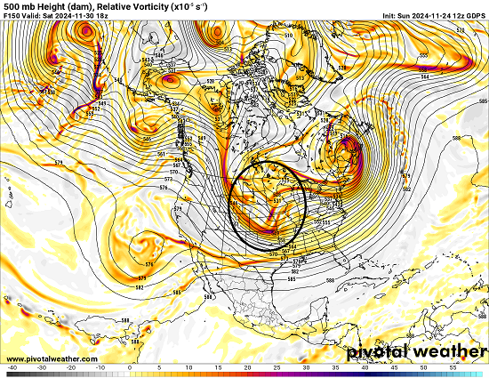
-
Blowvember - and not named for wind potential
Typhoon Tip replied to Go Kart Mozart's topic in New England
i dunno - i think a 'fair' subjective impressing ( ...good luck with that in the court of public opinion and social media's razor sharp equitability ...) is that what is presently modeled there is thrilling... i get it that is is not a stem-wound bomb potential ( as is ..) but that's not fair lol in part, we've not had this sort of pattern look, nor one that is entered by that kind of set up... since perhaps 2008! also, this is advancing in climatology, thi sort of look below, by several weeks or more. between the former and this aspect, this is an unusual total pattern loading and any potentials therefrom should also in the fairer sense draw some attention. -
December 2024 - Best look to an early December pattern in many a year!
Typhoon Tip replied to FXWX's topic in New England
what i find interesting about the outer <-- correction tendencies we've been observing ( i mentioned last week the wpo's been guilty of that as well fwiw - ) is that it seems the mjo is ( thankfully ) demonstrating early in the year ( thus necessarily reeducating people ) that it's not a pattern forcing mechanism, but is a reenforcer. the surrounding hemisphere has to be mechanically in sync it appears there are other motivating factors that are favoring a front loaded winter, and that they are suppresing/destructively interfering with the mjo in the right side of the rmm/marine continent. -
Blowvember - and not named for wind potential
Typhoon Tip replied to Go Kart Mozart's topic in New England
suggest 80% eps/geps blend weighting against gefs 20% - so not discarding the flatter appeal altogether, some inclusion in the latter is okay given to the quickening flow around the epo cold loading that's currently taking over continent. the gradient physically forces this latter aspect the flow's likely to speed up ... which unfortunately plays right into the gefs model system's subtle progressive bias that it inherited from previous versions - those were worse with that particular bias. i don' know about details with ptype and where. i'm just talking about averaging for a moderate fast moving cyclone. out of town. i shall miss whatever that entails -
Blowvember - and not named for wind potential
Typhoon Tip replied to Go Kart Mozart's topic in New England
the over all mass field handling between the date line and south of greenland is idiosyncratically different in the gfs. it's conserving a flatter rna signal, and that is in fact a constructive interference with the -nao phase states. so..it's just stronger with the nao because of it's flatter pna. the positive pna is technically unstable -aam load and usually doesn't last if it is in tandem with a -nao. the stable orientation is a +pna/+nao is the eventual rest state - this is technically more true in jf than nd, but it's vaguely there ...it comes down to in situ wave lengths. since we appear to be handling longer wlen like it were already in mid winter ...than the shoe fits. euro stronger pna = weaker nao = less suppression gef weaker pna = stronger nao = more suppression -
Blowvember - and not named for wind potential
Typhoon Tip replied to Go Kart Mozart's topic in New England
the nao is actually overbearing on this version ( gfs ) - if fact, that may be part of why it has been flatter than the other guidance since it started selling the bigger nao yesterday. may or not be so - but that's suppression -
Blowvember - and not named for wind potential
Typhoon Tip replied to Go Kart Mozart's topic in New England
something else i wanna add. it's low consideration but non-zero. there's a predecessor system around the 26/27th that scoots up as an eastern lake cutter, .. up the st l seaway. it's trended into an important system. one aspect of which ... it appears now capable ( as modeled ) of laying down a near-by cryosphere through ontario. that's actually a help in modulating low level cold supply. -
Blowvember - and not named for wind potential
Typhoon Tip replied to Go Kart Mozart's topic in New England
be an interesting eps coup for a week out over the gefs, because the latter's all but oblivious to next friday. i have to say, there's a new +delta emerging in the pna coming from the eps and geps ... it's gained more coherency over 3 consecutive cycles. this 12z run is a flat out mode change at this point. it should be noted, when +d(pna)'s take place during or post recent -epo's ... that is the typical prelude before cold loading along the mid latitude continent. in basic concept, that's establishing baroclinic/ambient polar boundary, thus enhancing storm genesis potential ... and dopamine gets injected.. heh. anyway, usually along the colorado - nyc axis. however, the gefs is much more neutral with the pna - even as of this 12z this morning's run it's not having it. not sure i trust that given the super synoptic ( and for lack of better word, 'intangible' ) trends. plus, the operational gfs actually came half way back more coherent with the 29th system over it's 00z run. something is there, and it's winter of profile... it should also be noted that the gfs had no problem carrying a 29th system through yesterday's runs. so it has a history of abetting the idea there. this is a sub-index scaled event. it's upside is probably limited to moderate in scope and scale. but, those are more apt to make us suffer some stochastic model handling. i want to start a thread but i'd like to see all three ens means at least trending in the gefs. it's the first real 'winter pattern' event trackable of the season and is worth of a separated discussion imo and confidence but in deference to being so early in the year ... heh -
Blowvember - and not named for wind potential
Typhoon Tip replied to Go Kart Mozart's topic in New England
12z nam backed things up a bit too - not sure if the graphical presentation gets that far west, but the fous for logan is an inch of cat paw white rain -
Blowvember - and not named for wind potential
Typhoon Tip replied to Go Kart Mozart's topic in New England
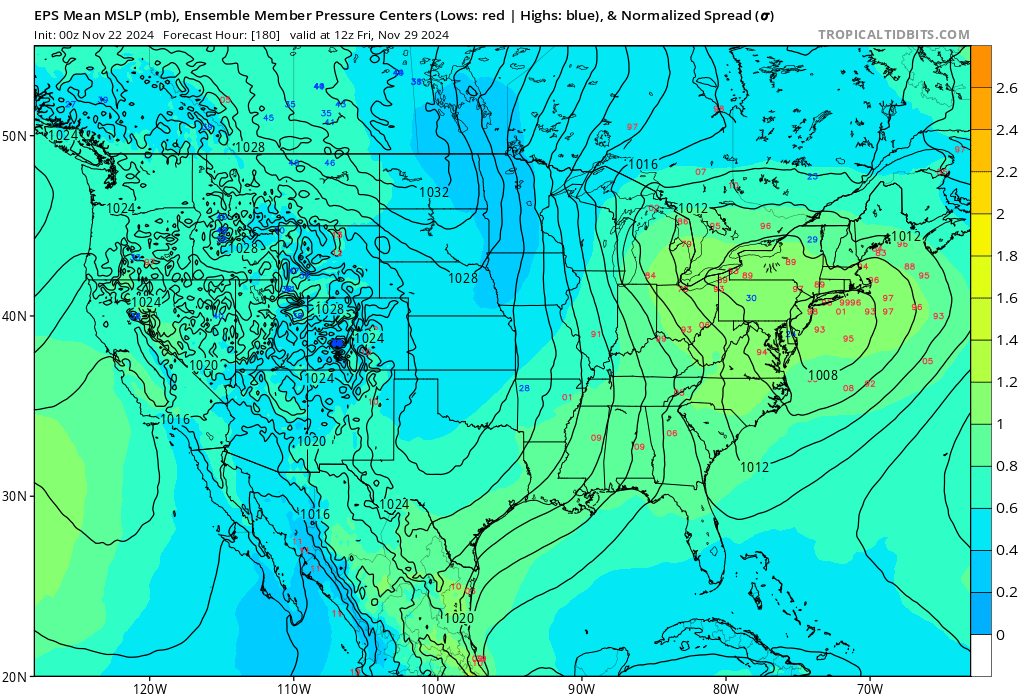
hmm... depends on what source one is using? this is the best ensemble presentation for that 29th thing to date, 00z eps mean. part of the problem with this event in guidance, other than that tiny little in "180" for time range ... is that it is sub-index scaled. the models will be more stochastic with small domain space events than they will with large mass field -directed majors. in other words, wait it out a couple of days is kind of obvious
-
Blowvember - and not named for wind potential
Typhoon Tip replied to Go Kart Mozart's topic in New England
yeah this system was inverted ( laterally ...) all along in the models. it's a diving -d(nao) under pinning low event, that is arriving on the heels of an antecedent warm pattern - consequentially, there was a defined dearth in cold leading the system environment. the cold is on the south side of the circulation because of that anomaly. and ... what east and/or northeast trajectories there were( you know all this ... ) ... gom buoys are reporting 50 to 52 ssts it's just is was a typical gloomy november deal -
Blowvember - and not named for wind potential
Typhoon Tip replied to Go Kart Mozart's topic in New England
didn't ask me but agreed ( bold ) it's marginal+ environment, but so far there are ptype rad returns west of the capital district, already, prior to best dynamics and also, albeit fractional ... it's a colder leaning quagmire during the night at this time of year.