Typhoon Tip
-
Posts
44,524 -
Joined
-
Last visited
Content Type
Profiles
Blogs
Forums
American Weather
Media Demo
Store
Gallery
Everything posted by Typhoon Tip
-
September vibes - Last 90s for some, 1st frost for others
Typhoon Tip replied to tamarack's topic in New England
i know.. 'dry begets dry' i guess -
September vibes - Last 90s for some, 1st frost for others
Typhoon Tip replied to tamarack's topic in New England
this morass down the coast and over the waters s of li is all being generated by a 582 dm close surface/circulation envelope. 582 it's a single contour closed remnant of whatever that thing was that came inland down there the other day. yet it has all this presentation like it's way more. it's always a reminder in this game how much relativity is everything. it doesn't matter that 582 hgts can have 100f at the surface - which makes 64 and rain a very low bar for that metric. or that a single contour is weak by any standard metric or convention, in general so why the big mass. it only matters if the surrounding medium is allowing it to become the dominating force at that time -
September vibes - Last 90s for some, 1st frost for others
Typhoon Tip replied to tamarack's topic in New England
seein' as no one at all asked i'm hoping for a 2-3" basin deal/bust high ...that fades by saturday and the sun's back out by noon. nice sunday follows. -
i was wondering if we might see a week or two late anomaly on that myself, but perhaps that won't be the case. mostly because the indexes seemed to suggest less favorable retention into these first weeks of sept. arctic oscillation going negative in latter august and so forth. it seems sept 7 to 15 is the corner-turning week when looking at that historically. not sure about all years in that but just a cursory look at the curves. that might be an interestingly damning signal at some point in the future. say if some tortured retention year ... then goes on to actually waiting to turn the corner until a couple of weeks later. - the ultimate threshold crossing, so to speak. the thing is, on sept 15 the sun is crawling along the horizon at the geo n pole. by this sunday morning, it's twilight there. it's not a huge intuitive leap to guess why sept 15 tends to formally end the melting, when talking about ssts of 32 F losing solar input at that time. so in a sense, that should leave some combination of the background climate, together with whatever pattern anomalies and heat transporting in, as the remaining forcing for any such extension of melting. so if it were belated and the pattern isn't as obviously culpable ..well that doesn't leave much else and that would scream a threshold. hell, if nothing else, good science fiction. lol
-
there's a lot of urban layouts across the continent that have not arrived through time with as much expansion, where also observing proportionate gains in t averages ( relative to their specific climate). the idea should be consistent in the integral of the curve - which it is not. in other words, the rises have been ubiquitous, while the rate of urban expansion was too variable to logically conclude hi effects 'as much'. i did not say phx's growth in that respect is no factor. no issue with that. what i said was, it's mostly climate change. and it has to be anyway, because the climate provides the environment for the uhi feedback - not the other way around i might be mistaken here but i suspect folks are thinking that the consiliency of cc is actually not considering the urban heat island in the data ? no
-
September vibes - Last 90s for some, 1st frost for others
Typhoon Tip replied to tamarack's topic in New England
not sure what the precise climatology/calendar is for this but for the use of figuring out when looks like the first regional frost potential in the first few days of october - that'd be my estimate based on signals -
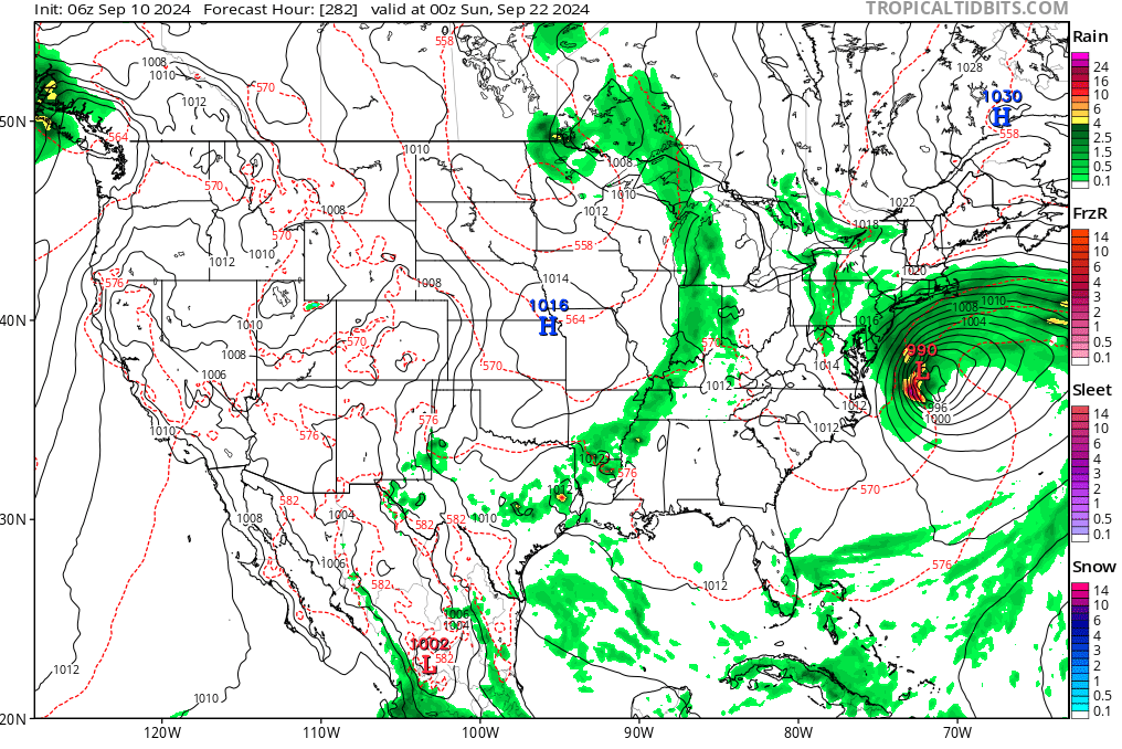
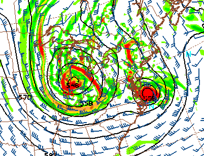
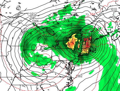
i'll bite... a flip in the pna leads to a trough digging s. this feature closes off, doing so with perfectly exquisite timing. what could go wrong at this time range huh nevertheless, these flow changes in general, draw a tc out of the caribbean, across cuba, over florida ... while interestingly, not weakening it appreciably enough despite encountering these land regions. then it even intensifies further as it comes n astride the western side of the g-string waters down there. closed low ultimately sucking it into it like a star wondering too close to a blackhole. one should gather an impression of how this above ends up after this frame.... if you guessed this, ... you guessed wisely. however, none of which is either a statement of forecast from me, nor is very likely at this range to be correct but that's understood. the main usefulness of this model's 00z run ( for now ) is that it is the first entertainment/eye-candy in probably 40 days worth ennui so crushing as to challenge the very endurance of man
-
i do see a pathway to vulnerability ioa the gulf/florida and the se out there in the d7-12 range. it has to do with the wholesale change in pattern in the main belt of the westerlies from easern asia all the way around... in short the powerful positive wpo, which has really predominated and forced a kind of pattern lock down over the last 10 days - i time which has been more than decent to use here in new england, much to the chagrin of the responsibly minded disaster zealot posters in here ... - is finally indicated in all major ensemble clusters to collapse. that translates a repositioning of the l/w progression through the np ... ultimately across n/a after some lag. it does a bunch of stuff but the main take away is the entire flow paradigm modulates anew. a transient positive pnap through the west teleconnects to nw flow over st louis mo, which in turn tips the deep layer flow s along the ec. whether these models like the recent ggem and the gfs are right about that western car. tc that's a sides the changes above. but.. if a tc is there, the former provides a means for it getting drawn into the interest region(s). predicated on the idea of these ens based mode changes working out, that gives a window
-
i suggest if folks expanded/considered this research over the whole globe they may find mid latitude velocity anomalies elsewhere, as well.
-
Occasional Thoughts on Climate Change
Typhoon Tip replied to donsutherland1's topic in Climate Change
unrelated observation ... but, that cool region in the mid west is interesting. i read material - perhaps links provided in this site's climate threads - related to farmland irrigation practices causing that. elevating evaporation mass lowers the temperature, but stores the energy in the dps might be interesting to see this product as dew points and then overlay - -
It’s mostly climate change… I’ve never bought it that the urban he Island is a big enough factor in this thing because frankly, the urban heat is has been there since the middle of last century. So it’s on both sides of the trendline, and therefore should be equitable and eliminated as a common factor
-
not 'sea ice' per se, but is a close cousin. https://journals.ametsoc.org/view/journals/clim/37/18/JCLI-D-23-0396.1.xml
-
A significant enough number of them have been a straight shot like that in the history books. It’s just the specter of 1938… And Gloria, those kind of long track buildup of anticipation
-
it's almost like folks are waiting for a difference, when it is far more obvious we are not deviating enough from the longer term reality (multi decadal) of arctic ice loss. we could have two relative 'gain years' back to back ( tho I almost doubt that is physically possible at this point) and it still would not deviate from that reality. because the next 5 years would just end up less than where it all was before the 2 gainers. until CC stops ... i see no other destiny. guess the purpose of this monitoring is to guess the day it is all gone? heh i will say this though ... my own observations/data over the years suggests that the rate of seasonal recovery is more important than the scalar value of the ice at the seasonal nadir - if one is in this for lag correlations on winter proficiency for cold into mid latitudes. may be something about the cyclic nature of pv integrity ... when it's strong early ( hence, +d ... ), it seems to naturally decay into years of better blocking by mid winter - perhaps because modes typically reverse ( but not always - ) every 45 or 90 days. this model that I am describing has always led me to more interest in monitoring the state of things as we head into october and november ... i have to say though, with the crazy pattern behaviors, non-dependability has my confidence rattled that any model is very useful anymore.
-
yup not for not but i stated 2 months ago across a couple of posts that there was a dearth in both frequency and potency of tws leaving africa. point being - to me - is, why wasn't the f(tw) and p(tw) taken into consideration during seasonal forecasting ? - or perhaps more apropos, when did that change? i can remember back in the 1990s ...whence colorado state u had formulated means to forecast canes with better than 50% success, and one of the key variables was the tw stuff. it seems the absence ( or weak profile ...) of that factor should/could have modulated forecasts much earlier.
-
Occasional Thoughts on Climate Change
Typhoon Tip replied to donsutherland1's topic in Climate Change
https://www.theguardian.com/environment/2024/sep/12/entire-earth-vibrated-climate-triggered-mega-tsunami#img-1 edit: actually that link isn’t loading properly… Just go to “the guardian” And search on this title Entire Earth vibrated for nine days after climate-triggered mega-tsunami interesting … I recall, reading about a seismic event on the interior part of the Greenland ice sheet many years ago during the beginning of the hockey stick warming of the earth. Period of climate change… It was subsequently theorized that it’s possible that a large majority of the interior ice sheet could ultimately fail in one single cataclysmic event sending much of the ballast of the ice into the sea the north Atlantic… Setting off a global tsunami/abrupt sea level rise of a couple of meters or more So these kinds of things are happening above and it’s really not too too dissimilar to that just happening on a much smaller scale -
September vibes - Last 90s for some, 1st frost for others
Typhoon Tip replied to tamarack's topic in New England
as observed by morning sat this smoke won't last long this morning -
i dunno if it takes a whole helluva lot of category to cause major problems for the dumbest location of civility since pompeii tho
-
Occasional Thoughts on Climate Change
Typhoon Tip replied to donsutherland1's topic in Climate Change
love it ... the guy's on point, too. op ed: sometimes one will start watching one of these and they'll get 5 min in when seamlessly ( or tried to ) it becomes why the 2nd coming and rapture is upon us. or something will just seem off until finally it dove tails into a liberal conspiracy to scare humanity about the end of the world. society really needs more of these sort of paraphrased articulations, those that simplify [perhaps] that which is too complex for the majority of background population. part of the problem with reticence and lack of acceptance ..etc of environment and the travails et al, is really just for loss of awareness before even going into any discussion. there's a gap there. too many are not connecting fast enough over what they are being told, because they don't know enough to begin with. we don't need to be psychologist to sense that it's easier to dispense of any message that does not resonate. and it gets worse when we think about the conditioning since the industrial revolution. there's a negative feedback from convenience [addling], that's compounding over successive generations. denying just about anything is privilege to do so, enabled by the relative safety of the industry realm. i read somewhere that the average i.q. is some 20 points lower in modernity compared to the a 200 years ago. having access to more information doesn't make one smarter. the information has to by virtue and willingness to the observer, actually get learned. the processing intelligence [think working a muscle ) is also weaker. why is all this so? it is because we are soaked with choices and recourse, such that there are far less ramifications severe enough. minds are not predicting consequence prior to actions or idiocy, when losses are not perceived as permanent. this stuff has been touched on by literary works since the advancement of the printing press. it's not really novel. but the point is ... cc to micro plastics and all of it, it doesn't appeal to people that have no receiver to get the message. these quick-for-low-attention-span exposes are useful to the lower attention span that comes with an "Idiocracy". -
Occasional Thoughts on Climate Change
Typhoon Tip replied to donsutherland1's topic in Climate Change
yeah no idea what/who owns the biggest pie slice... i just find the implication interesting. given ch4's greenhouse efficiency being an order of magnitude+ more so than the co2 ... this all becomes academic if all these human ch4 sources, team up with arctic perm frost release ...etc and et al, and simply outpace any modeling or predictions and the like. methane has a much short half life tho - -
September vibes - Last 90s for some, 1st frost for others
Typhoon Tip replied to tamarack's topic in New England
well for starters ... ha-ha or not, the gfs has been attacking that specific region just like that since april. not sure what in fractal's hell creation is causing this repetition in that model ( and in some senses ...i'm seeing in the others, just not as elaborately - ) but i think it has something to do with a primitive integration technique for the interaction of the lower troposphere with the planetary surface features. is it just an accident that that cold belt there almost exactly mimicks an atmospheric version of a Labradorian penis ? -
Occasional Thoughts on Climate Change
Typhoon Tip replied to donsutherland1's topic in Climate Change
https://phys.org/news/2024-09-methane-emissions-faster.html -
September vibes - Last 90s for some, 1st frost for others
Typhoon Tip replied to tamarack's topic in New England
i don't believe this gfs crap at all
-
this might help elucidate the above facets ... https://www.cpc.ncep.noaa.gov/products/precip/CWlink/ir_anim_monthly.shtml loop that. you can see this hemispheric scale neggy uvm potential has stalled over the americas now on 45 days and gaining. this is directly related to suppression throughout the basin ( this may also be evidenced by mid and u/a thermal conditioning though i haven't checked ) normally, these regions of 'green' and 'brown' are propagating around the globe, as each passes through, tendencies for increased(decreased) tc genesis are observed. green is where tc enthusiasts wish to be. not shit stain brown. and, not shit stain brown not propagating - it doesn't mean we can't get events to unfold ... but 'explosions' of activity are a lot less likely. playing into a loaded deck
-
September vibes - Last 90s for some, 1st frost for others
Typhoon Tip replied to tamarack's topic in New England
yeah didn't explicitly mention that but the high parked over head is the actual idiosyncrasy i had in mind, which stops it from getting hot in the current model appeal it's alright for out doorsy stuff. by the way folks, lots of color, more so than just the typical 'sick maple,' dapples the distant groves around here. my big corner maple, healthy and stately, which i lovingly refer to as general sherman, is tinging orange a goodly 3 weeks ahead. i'm hypothesizing that the week of severe smoke we dimmed solar with for 10 days earlier last month might have triggered a bit of a green pigment pull-back if prematurely. these are healthy trees tinging around here, and i found that observation consistent along rt 2 and down 91 toward worcester over the weekend.