Typhoon Tip
-
Posts
44,833 -
Joined
-
Last visited
Content Type
Profiles
Blogs
Forums
American Weather
Media Demo
Store
Gallery
Everything posted by Typhoon Tip
-
Blowvember - and not named for wind potential
Typhoon Tip replied to Go Kart Mozart's topic in New England
yup... the ski industry gets a nice start out of these next two weeks for that matter. probably be summit squalls regardless - -
Blowvember - and not named for wind potential
Typhoon Tip replied to Go Kart Mozart's topic in New England
sure is nice pattern eye candy ...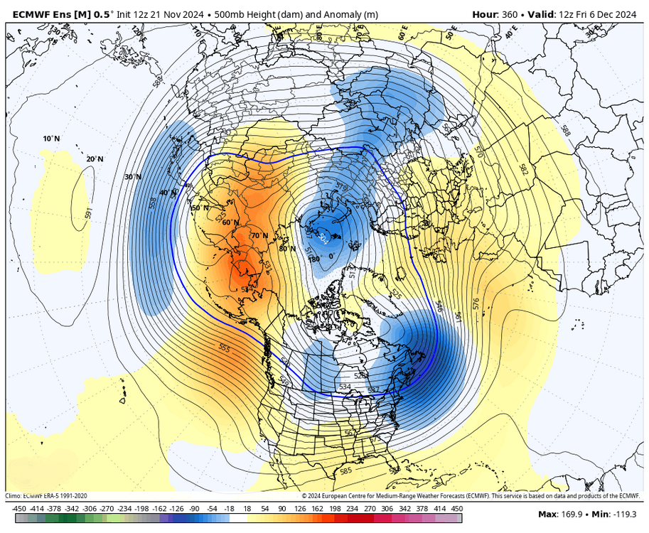
-
Blowvember - and not named for wind potential
Typhoon Tip replied to Go Kart Mozart's topic in New England
although ... the probability is going to be higher up by ray's place than kevin's due to where they are in relation to the system. -
Blowvember - and not named for wind potential
Typhoon Tip replied to Go Kart Mozart's topic in New England
i'm not speaking for Will but ... i don't think tomorrow night was really very high confidence to begin with. in my mind, it's possible - that's about it. it's up to the reader to be fair and honest about what that means. it's probably 36 to 39f through the region, with period light rain and cat paws in a stiffening n wind as that ccb clips the region ... but it's not long lasting either. it's probably just cloud and raw with wind in the afternoon (sat). this may perform better on mt wachusett and monadnock -
Blowvember - and not named for wind potential
Typhoon Tip replied to Go Kart Mozart's topic in New England
yeah... ironically, i recall just yesterday mentioning that without out or nominal polar high north of the region, we can still pull off an event by so-called 'needle threading' this is pretty much exactly how the 12z operational gfs gets at least a 34 f type of event through the region ( ~29th ). the 2nd's still also on the table btw - -
Blowvember - and not named for wind potential
Typhoon Tip replied to Go Kart Mozart's topic in New England
yeah.. it's too marginal to snort a line over. i'm just relaying what the grid has. it could be white rain just as well. but that's the coldest gridded thermal profile regarding that retrograding ccb i've seen to date. it's actually not even isothermal. 800 mb is -3c ... 900 is 0c and the bottom is +3c. shallow warmth and you can soak cotton balls at 37 .. 38 for non-accumulating ptype when the 900 and 800 average neg. fall rates can exceed melt rates at that chilly sfc reading -
Blowvember - and not named for wind potential
Typhoon Tip replied to Go Kart Mozart's topic in New England
that 12z nam fous grid is wet snow at Logan to almost 1” qpf sat morning -
Occasional Thoughts on Climate Change
Typhoon Tip replied to donsutherland1's topic in Climate Change
not sure if this should go into the pollution thread or here but ... great. now we've got a mechanism discovered that overlaps the plasticizing the environment, with factors that push climate change https://phys.org/news/2024-11-plastic-krill-ability-carbon-deep.html the two pillars of environmental concern, plastic and climate ...have largely been considered two separate problems - at least implicitly. but molecular polymer pollution interfering with the CO2 fixing capacity of the oceanic biota shows the two do have some possible feedback relationship it should be noted, ~33% of the CO2 produced by human activity since the IR has been eaten by the ocean. much of that capture is within mms of the surface. however, as the ssts warm the physics of this absorbing layer means less absorption. but there are other processes involved. -
Blowvember - and not named for wind potential
Typhoon Tip replied to Go Kart Mozart's topic in New England
i dunno - it sounded like you were letting the current presentation of -wpo/-epo pacific make you nervous about winter. i probably read in too deep. haha. but just sayn' i wouldn't do that. the problem i have, which just about abolishes all confidence in what djf turns out is that ... mm nothing we are seeing now ( according to my recollection ) is different from those snow shot across the bow events that preceded a lot of the piece shit winters that we've suffered over the last decade. that's a. b, i can come up with a hypothetical posit as to why ... it has to do with when the gradient of a warmer than normal mid and lower latitude hemisphere presses (seasonally) against the lowering heights above; that enhances the gradient and as recent seasons have shown, is offsetting the longer termed seasonal telecons - ex lending to episodic decoupling of the enso from the mid latitudes with increased frequency ... just one example. but also, the speediness of the hemisphere gets going in a month or so from now, and that kicks in another charm about gradient surplus: too much velocity. the intraseasonal telecons, like the wpo, epo, nao and pna, they're having trouble maintaining pattern biases at all ... stochastically vacillating between positive and negative modes ... this stuff is most likely going to happen again. -
Blowvember - and not named for wind potential
Typhoon Tip replied to Go Kart Mozart's topic in New England
you're eliding the point: yeah, but the processes involved are doing so when it is not typically a snow to begin with. it's alright. like i said ... you can penetrate the shroud of emotion-influenced attitude with reason, right or wrong. wrangling emotion cats .. .heh, i like that one. i just don't think anything about this system as being 'unfair' when the "evolution of the system and the processes involved" are actually ahead of the climate curve for this time of year. yeah, there's some positive 2-meter temp anomalies N-W of here. i'll give you guys that .. but in fairness, this system is over-achieving if anything when considering the total synoptic manifold and all parametrics -
Blowvember - and not named for wind potential
Typhoon Tip replied to Go Kart Mozart's topic in New England
futile to try and wrangle in emotional cats buuut, how can there be an opportunity missed when considering climate at this time of year? in 1750 this would not be an opportunity lost. if anything...it's a gain having this behavior on the map in general. it's a presage ( possibly ..) for winter, to establish coastal tendencies now - that is all. anything else beyond that dopamine ( lol ) is in fact more than normal. again ...this is just me - to each is his or her own. the latest guidance trending cold rain and cat paws, with elevation wet snow? that is just about exactly what the norman rockwellian climatologist and arm chair pipe smoker would recall of any novembers of lore. see ...realistically, we don't start missing opportunities until the the expectation aligns with winter climate, when it is actually supposed to do so. -
Blowvember - and not named for wind potential
Typhoon Tip replied to Go Kart Mozart's topic in New England
if it were me ... i would disconnect this period from winter. -
Blowvember - and not named for wind potential
Typhoon Tip replied to Go Kart Mozart's topic in New England
yeah that new deepening was a risk for capture. not sure a nam solution can’t happen. marginal+ but in a dynamic vertical mixing with a burst of fall rates punching w right into that? … that could easily go over to soaked cotten balls out toward Orh and Rt 2 looks like a ccb. -
Blowvember - and not named for wind potential
Typhoon Tip replied to Go Kart Mozart's topic in New England
there it is … nice moderate flat wave event 28/29th scary to suggest this for an 18z gfs run … talkin over a week away, but that really is the best fit construct for the type pattering at that time. I mentioned this earlier … not the euro, but stretched system type yes. Unless there’s some fundamental changes in the pattern foot. hell it is 8.5 days out. -
Blowvember - and not named for wind potential
Typhoon Tip replied to Go Kart Mozart's topic in New England
ha! yeah, guess we can say our suspicion over the euro reversing the 28ther and the 2nd was the right idea, huh. but i'm not sold or saying that the 2nd is dead, either. i suspect this 28/29th, 12z dopamine may modulate to more of an open wave event. doesn't mean it's has to be a piece of shit either. it's just that the closed deep juggernaut thing is iffy in that general hemispheric look - flow's too longitudinal with flatter l/w structures to see that thing move through like water going around a stone in a stream like that. anyway, i could see both system's being legit but conserving that super synoptic structure, the cyclic dimes might be a better fit. lot's of time ... frankly, i'm still higher confidence for storm activation like several days ago - that's not changed. i'm just concerned about cold and whether that aspect gets attenuated as the time(s) near... -
Blowvember - and not named for wind potential
Typhoon Tip replied to Go Kart Mozart's topic in New England
i'd even settle for just getting cold boundary layers - that's really the barest necessity. highs ideally placed is obviously optimal but failing that, a cold residual air mass with a low running by underneath can get the job done. i mean, we haven't really had much success even 'threading the needle' s either. -
Blowvember - and not named for wind potential
Typhoon Tip replied to Go Kart Mozart's topic in New England
there was discussion like this back before the 1989 event if memory serves. -
Blowvember - and not named for wind potential
Typhoon Tip replied to Go Kart Mozart's topic in New England
the icon has a bit of a stinger look early sat ... i'll go ahead a this post but, i'm not really sure that potential should be ignored. there's a tendency to start conserving more deep layer mechanics with this closing system, nuanced in recent guidance - there's always a bit of variability headaches with these. the icon's trying to say light to moderate cold rain a 534 dm thickness at 12z saturday at the sw arc of a wrapped ccb, around that new deepening... i find that to be warm biased in ptype given that totality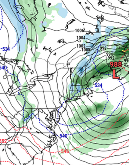
-
Blowvember - and not named for wind potential
Typhoon Tip replied to Go Kart Mozart's topic in New England
you're gonna need another vomit emoji - -
Blowvember - and not named for wind potential
Typhoon Tip replied to Go Kart Mozart's topic in New England
commented about this the other day too - watch that new deepening low passing e of bos friday night. it's not part of the nyc cyclone but is a new committed development. there's signs that western arc could 'fill in' - perhaps assisted by the instability of those tanked mid level colder heights like you're saying. yup -
Blowvember - and not named for wind potential
Typhoon Tip replied to Go Kart Mozart's topic in New England
probably a day ... day and half to thread -
Blowvember - and not named for wind potential
Typhoon Tip replied to Go Kart Mozart's topic in New England
yeah... not to be a dink, but ..when a i wrote about the double potential (~28th then again ~2nd) earlier, i mentioned the 06z had stepped back ... but that i was fairly confident, based up recent model performance for that 10 day period out there, that it would return. that feature is showing up strongly in the eps - albeit on the 00z run it was more of an eastern lakes cutter with perhaps torpid commitment to secondary - but enough to sense there's some residual bl cold/resistance forcing that to happen. however, the euro operational was nix on the 28ther and selling the latter 2nd much harder on the 00z run cycle. it'll be interesting to see if the euro starts to reverse those - or perhaps carries both ... on the 12z run. -
Blowvember - and not named for wind potential
Typhoon Tip replied to Go Kart Mozart's topic in New England
that's why i put the drought term in quotes in that snarkism - i wasn't gonna get into survey gunk -
Gulf Stream to Shut Down this Century
Typhoon Tip replied to 40/70 Benchmark's topic in Climate Change
ah,... it's (somewhat suppositional ) but I don't see the fl straight as much of a mystery ...yet the aspect to me, which is rather intuitive ... is geometric bottle-necking. a lot of mass has to move through a small region down there. the 80% still active amoc is still a huge mass quantity compared to what can geophysically squeeze through that region near florida. if the ~20% lowering of the total basin amoc exchange machinery is still above the critical mass continuity thresholds, then it's simply a matter of there still being enough mechanism in place to continue draw the sw atl basin waters out of that region - where mass-continuity keeps velocity/mass transport sufficiently high. most likely, it's gradual ... not yet begun. fl straight starts to decline more gradually across a range of total basin amoc weakening, but doesn't likely begin registering change until the total basin weakening crosses some critical value, but it is > than the present 20% in this idea. -
Blowvember - and not named for wind potential
Typhoon Tip replied to Go Kart Mozart's topic in New England
unfortunately ... y'all are gonna have to shut down the d-drip over this "drought" and fire hysteria. you'll get a chance to enjoy getting event stoned soon enough ... but .8 to 1.6 basin coverage is plenty to significantly enough retard fuels in the combustion triad, and that's going to ruin your high. lol as far as what happens after, this is an entirely new pattern ensuing. there are multiple potentials for maintenance/ sub index scaled events that were not there during the dry recency.