

Typhoon Tip
-
Posts
44,564 -
Joined
-
Last visited
Content Type
Profiles
Blogs
Forums
American Weather
Media Demo
Store
Gallery
Everything posted by Typhoon Tip
-
What's more needed there is a discrete study that statistically correlates larger systemic precipitation events over eastern N/A with North Atlantic Oscillation's specific ranges, during predefined eastward vs midriff vs westerly biased -NAO ( +NAO ). Said study should look at each when: - in static (relatively unchanging mode); - vs when they are changing/ their curves are excited to increase or decrease ( modality ). The blanket usage and assumption routine over the NAO is fodder for too many disagreements and at times 'stressed' vitriol, and an actual science may help clarify matters and usage. Furthering: The only study that I am aware that actually attempted an accredited/discipline approach to the NAO@ 'storms' ... was papered back in the 1990s by Heather Archembault - although I am sure there are other papers that mention it indirectly, of course. I have read her study and its primary focus was the Perennial North American patterns ( PNA)'s mode versus modality. During that read, she mentions as part of her summary efforts, that there is a 'similar' response in the NAO, but that the signal was less clear. That does not mean a more coherent signal cannot be gleaned via a different more focused study/approach. I think the study needs to be had and I really wish it would. Because when the NAO was popularized roughly around the 1980s, weather-related graphical media explosion ... over-sold it to an eagerly receptive audience. That era became weather and science for entertainment as much as informational -> and on and so forth. The timing was right for it's meteoritic rise to fame and celebrity as the key-stone winter cop index. NAO, OOH....wow ..yeah, North + oscillation - sounds cold and scary, caught the tidal wave of free advertisement in that era, and we're left with it still to this day. And it's like institutional racism now... Man, people bounce their heads off the wall assessing it's necessity in forcing cold(warm), wet(dry) scenarios because there's a culture built-in assumption that it does .. And, assuredly it has to, to some degree. It's an indicator of mass field, and since all mass is conserved... it's sign has to mean something. But, the question is, how much or how little, based upon those crucial conditions above - it would go a long way to help guide in when to use it. We can all agree, at least anecdotally, the -NAO has been prevalent < 50% of the time ( and in fairness? Probably less than 25%!) since 2000, a 20 -yr span in which Boston/Logan has verified enough boon-time in snow to demonstrative move the 30-year average an alarming amount given that short period of time. Clearly, then, there must be a disconnect between the subjective perception over the NAO necessity, as it is needed to snow here - when at least at that one location, that's proven untrue. But who are we kidding. It's been that way at all climo majors - Anecdotally ... we all know there is a pretty coherent different large scale forcing in the circulation medium over this quatra-Hemispheric scope and scale depending upon idiosyncrasies in the NAO layout, and therein ... whether the index is rising ( falling ). But, personally... I believe the NAO is loaded ultimately by PNA by R-wave/resonant dispersion down stream ...given time lags. We could probably find the same signal as it is emanating source, from that wave decay model/ origin. Aspects in the atmosphere do not spontaneously emerge, in situ; rather, they are delivered to the location constructively, until thresholds are breached and said location has gathered enough momentum for the phenomenon to blossom into registered observation - the NAO "comes from somewhere" ... it ain't coming from the E in an atmosphere that is bounded by geophysical laws dictating moving the atmosphere from west to east.
-
I think/thought it was earlier than that last week's guidance envelopment; Christmas cutter contributing..but ... winter enthusiasts should hope two things don't happen: 1) ... this turns into an always on D9 chart and it fails to get into short 'verifiable' terms ( until May 13 of course!) 2) ... it surges into dominance so strong that it's suppression madness. We want -1 NAO's in the mean that fluctuated around 3-5 day periodicity toward positive before collapsing - right in there is the Willy Wonka gold ticket. Not sure about the current PNA --> PNAP variation either - this things starting to chap my nerves.
-
Firstly ...not really re the 'blocky' - that's so far E it's almost outside of the NAO domain space ...and in fact, that massive SPV eclipsing from the west is so deep it's likely pulling any EOF calculation positive. But I'm glad you posted this polar stereographic view ..because it partially explains now how/why it manages to rip all S/W east of the Maritimes at a high latitude that is anti-climate for -NAOs ... It's not an NAO because of the hugely skewed typology there... As to the other, who said it has to look like anything - ...the argument is posed in concept, that when it doesn't ...it comes into question whether it can be right against the weight of all those ensemble members that thicken the means mass.
-
I just don't get how competitive the operational version are being against their own ensemble means - very bizarre ... That 12z Euro ( oper ) version cannot happen in that without some rare large scale anomaly - usually a comet impact! lol...no, but maybe if the NAO was exceptionally E-based, but given that position in the mean, it's not...So, it's got to be a pretty dramatic whole-scale systemic outlier... But the GFS is violating principles here in a different way altogether. It's opting to deconstruct blocking and just making it a top heavy subtropical ridge ... I 'guess' anything is possible -
-
Yup, I'm sure ... the "operational" GFS does not look like it's own ensemble mean signal argues it should -
-
thanks Dude - Yeah.. . I wanted see this before making this point. It's not exactly salient/novel or anything buuuut,.. the GFS solutions as of late simply do not fit that signal - not from the EPS, nor its own GEFs' -derivatives regarding the NAO domain. I don't even think the Euro operational run does very well either frankly - that 12z solution was a joke. Actually worse than the GFS on that one run. I'm talking about the D5 - 12 range. Something's not right - doesn't add up. tryin' to figure the f'er out
-
Christmas Eve/Day Annual Scrooger Event
Typhoon Tip replied to Baroclinic Zone's topic in New England
...yeah, 50 mile wide EOF2 tornado ...who's with me! -
Christmas Eve/Day Annual Scrooger Event
Typhoon Tip replied to Baroclinic Zone's topic in New England
Course there's the other school of gratifying Schandenfreude when/where there's pan-dimensional grid failure on the one morning of the year where the spirituality of the thing really needs to have it's electricity too, and - oh, wait, there's a word for that, 'GRINCH' ... lol -
Christmas Eve/Day Annual Scrooger Event
Typhoon Tip replied to Baroclinic Zone's topic in New England
If it means busting the HWW ? - yup ...100% confidence it will be right -
Seriously.. .does anyone have the EPS NAO ??
-
Gotcha... yeah... and actually, not that you or anyone cares for this opinion but I'm actually quite impressed with this season so far. In fact, if for some quirky reason the 29th comes back to haunt us, and we add? We're killin' it! ...but as is, I'd be happy ending Dec at 19 and change ...( and I bet we get 21 or '2 somehow some way ), we're doing fine. Look, I get it folks. It sucks to time a 9 hour deliberate assault on the one day of year people vest a currier&ives nostalgia around snow and apple cheeks and egg nog and icicles and hot chicks in elf costume ...But I'm lucky in that 2/3rds of my Xmas' have only ever had the hot chicks in elf costumes yeah right... ...I don't carry along expectations for snow on the ground or in the air on that day ...Cutter storms or warm intrusions in the winter are part of life even in New England - it just happens and think of it as a gift, because if you want bigger storms, you have to reset the pattern at some point(s) in time(s).
-
Screwed lol ... nah, not taking that bate - I will say, if you mean not getting 22" ... I did not get that much- but I got 12.5" which ...you know, when did 12" of snow become some kind of forsaken romance tragedy ...
-
I disagree with that assessment re La Nina continues to dominate - ... causally? I think the boreal hemispheric circulation is presently passing through, thus, 'mimicking' La Nina and is ephemeral ...in wait of next week when it doesn't yet again look that way, like so many times over the last 50 days. I just feel like there is an agenda to force the perception to lock into an ENSO signal that's not really there - ... just an opinion, and it probably is wrong so chill out. But I have been carefully noting over the last two warm ENSOs,. and the intervening modest cool one, a lack of truer coupling to the ENSO states - this was even noted by papers and NCEP themselves in the NINO discussions during the last warm phase, when it took untl the end of February for said coupling to demo. We have also seen ( anecdotally...) this year on numerous occasions October through early/mid Dec, more times than not the circulation not looking very La Nina like... So, when the writer states, "...continues to dominate..." that leaves me a bit nonplussed -
-
Great expectations ? I'm at 19.5" of snow here to date, which goes without saying is above normal. Obviously timing is everything... If we'd gale whack the hell outta the region two weeks ago, and then hit that fluffy snow storm tomorrow... tenor changes -
-
Christmas Eve/Day Annual Scrooger Event
Typhoon Tip replied to Baroclinic Zone's topic in New England
I dunno .. .thing is, I've seen more busts when it comes to 'wind' as an isolated threat metric than I can even keep track of in memory if I cared to even do so .. ugh. Now... admittedly, most HWW that don't materialize are in CAA ... What's funny about that - I've seen some where Warning gusts were met but no warning was issue more times - I think - than a warning wind forecasts have verified. Lol But anyway, of both .. these S gales do seem to stick out in memory as having some impressive canopy leaner wind gusts ...and there is also truth/physics to the notion of SSE winds causing more timbre damage because it's like the environment is not used to that wind direction.. or processed wind flow direction/maintenance -
Christmas Eve/Day Annual Scrooger Event
Typhoon Tip replied to Baroclinic Zone's topic in New England
Oceanic SST's are seasonally declining now in the bite waters/ E of Jersey ...I'm not sure that llv jet gets down into the bottom of the sounding if the water temperature is below the WB of the air mass over top. hmm. But hell... there's wind software products and experience so assuredly this has all been considered... -
I don't think there's going to be much left outside of driveway sides and curb berms ... This snow is still rather gossamer and flaky. You need some Italian ice to really lock in frozen actual mass - more mass requires more thermal input to change phase, so that is why a moisture dense icier snow pack is 'somewhat' more resistance to this sort of 9 hour siege of fire hosing. Saturation at 52 DPs being pelted along by white noise is likely to do two things.... obliterate all field snow ... roll steam plumes off snow banks...
-
yeah,.. .that is about as anachronistically out of sync relative to any negative NAO as is fluid mechanically imaginably wrong - So, the course of least resistance is to go ahead and assume there is no -NAO ... An SPV located in western Ontario moving into that location by D10 really can't happen otherwise. I don't know if an easterly biased NAO blocking might open up enough R-wave distribution spacing to allow that kind of exotic anomaly ... It seems that's too much either way - and it may be considering the Euro's depth/height bias beyond D5/6 ... But given to the horrible handling of the NAO ... now going on what 16 years of modeling ... it almost seems easier assume it doesn't exist. I dunno -
-
hearkens back to my hypothesis in late summer I was posting regarding the faster flows inherently interfering with NAO blocking regimes, too. Seems a nice manifestation of something like that here - The AO mode argues the PV is relaxed and that blocking should evolve... but something is preventing it from doing that. It's like the PV is large, just not weak...
-
Who has the EPS NAO data ? ...curious how our friends on the other side of the Atlantic screw job are lying ( or not ...) with this particular installment of back-stabbing blocking bullshit - haha... Seriously, though - I'm wonder if the EPS was ever selling what the GEFs have been, and continues to do so. Last night's derivatives are even more concertedly and sloping more negative ... steadily declining down to -1 and change over the next week. And if it makes any sense the "attitude" of that trajectory appears suggestive of locking in that mode? Which is kind of to assume any (-)(+) NAO would ever lock in any mode, just sayn' Anyway, recently I have been intrigued by the relative cyclonic motion between the upper and middle latitudes of the Hemisphere - subsequently, that constructive (positive) wave interference is more favored over destructive (negative). I am baffled to see the operational models figurative ( seemingly literally!) going out of their way to impose destructive interference at all spaces and scales despite that ... But, you know - I admitted there wasn't anything actually on the guidance at the time - although we have been flirting with this Dec 29 thing. About that... the only thing that really limits that from phasing into a major player here is that as the N/stream descends eastern Manitoba up there, and the intermediate stream finish injecting that Pac wave through the Plains ...is the whole scaffolding of the circulation medium over western N/A refuses to ridge more... That is a very important large --> small scale positive feedback that is missing - despite the above concepts... There are different forms of constructive ( destructive ) interference though - the R-wave structure is different than the subsume/ stream harmonics ... It's like we got one but are not getting enough of the other - interesting.
-
Yeah I geuss I don’t look at it enough. It says 00z 22 so word. still it was doing that
-
I don’t think I’ve ever seen that before This paranormal ghost model actually succeeds at having a retrograde NAO influence, and a progressive shearing pattern ....simultaneously
-
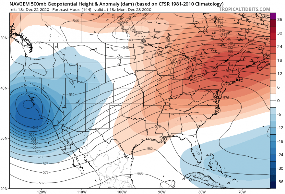
This is a classic -NAO signal in the NE
-
GFS has shown very poor continuity over the last several cycles/days worth of runs wrt to the N. Atlantic Basin air space. I'm not sure I'm seeing a hugely better return from the Euro oper. either. I've seen standard NAOs, then go west, east ...now ( like this 18z run ) so far S based it almost argues not to be really be "in" the NAO domain space enough to really be call anything other than a ...I dunno, a f'n north-based subtropical ridge out along 50 W-40W lon.. This run actually times the N/ stream to subsume and rock New New England wrt to the Dec 29 scenario; but just keeps the phased result too progressive to really clock the region... Owing to it's instead allowing more progression overall to return to the scaffolding of the entire circulation medium. A bit more down stream backward ply/exertion on the field returning, and that would probably do it - Part of the issue with the guidance is a regime change ... they don't usually present accurate aggregate performance... and then trying to manage that, WHILE delicate phasing on a D7 chart?? mm... The AO is still falling ...tho mop-ended, it may wend its way to a -3 SD mode by D10 ...and as it descends, it's overlap domain NAO is being handled improperly and inconsistently. That is 'normal' as an issue for that domains space ( anyway ...) given to model performance and the stochastic nature therein... but, no teleconnector is usually handled exceptionally well when they're in modality - particularly that one! So the AO falling, the NAO on the move, and the PNA showing longitudinal amplitude along a narrow positive mode ... mm ... I see next week as not having an imminent threat on the guidance, but having one because of the 'synergistic' nature ... which, emergent properties, like 'gestalts,' they can't really be measured as a deterministic product. ... Although the slowing of the wave propagation around 60N, whilst the intermediate stream continues to roll west to east underneath is an inherent cyclonic framework for constructive interference. It is in the correction tendencies that is lending here- fascinating actually.. Ah heck... Probably nothing happens, everyone feels smug, and veracity of this gets muted by faux perception - ...perfect!
-
I think you're all missing the boat on next week personally - never seen such wanton disregard for common/ -textbook theoretic correction needs considering what's going on - but,.. I also think there some good old fashion down home pissed off bad mood controlling the "objective" perspective in here today LOL Yah... 'support group' in full affect - Next week may not parlay ... and of course the "seeeee" parade ...but you'd be wrong - or, right for the wrong reason.


