

Typhoon Tip
-
Posts
44,539 -
Joined
-
Last visited
Content Type
Profiles
Blogs
Forums
American Weather
Media Demo
Store
Gallery
Everything posted by Typhoon Tip
-
Significant upper middle Atlantic S/CNE mix/snow potential Jan 3+
Typhoon Tip replied to Typhoon Tip's topic in New England
Middling climo cyclone; higher impact snow because of wet heavy nature; duration augmenting - nothing's changed - -
Significant upper middle Atlantic S/CNE mix/snow potential Jan 3+
Typhoon Tip replied to Typhoon Tip's topic in New England
I also would like to paraphrase/re-iterate: for now 33 to 44th percentile cyclone relative to New England storm climatology. However, its impact modulated perhaps more so by snow type, and duration. That's the overall look of this. We could snow 9" of blue bomb snow, and that's a siggy problem, and then if it protracts over more intervals for another bit it's ... It's sort of over-achieving in that sense. -
Significant upper middle Atlantic S/CNE mix/snow potential Jan 3+
Typhoon Tip replied to Typhoon Tip's topic in New England
Well... mind you, I'm speaking in deference to that solution - I suspect you are too but the reader may think that's the call ... Not ready to sign off on this outlier antic by the Euro ... It could be right. It's got some variance circumstance that offers more reasons than usual to doubt. Not to be a hypocrite: I have averred in the past that the Euro is not that bad inside of D4.5 and it should be factored more so than not. *However, this situation is a bit unique for the fact that -NAO and really ...entire hemispheric scope is 'uncharted model performance' territory - even for the Euro.. NAOs are notoriously fickle beasts ... -
Significant upper middle Atlantic S/CNE mix/snow potential Jan 3+
Typhoon Tip replied to Typhoon Tip's topic in New England
If it does that folks it won't 'back in' heavy snow ... that clown chart - whack that down by 60 some percent, easily - The NAO is blocking and sending that back SW: when that does that? It's always as a core wrapped occluded shredded wind whipped wet flurries, ... "fake" low visibility drizzle.. hot cocoa event. In fact, I wouldn't be surprised if that look eventually morphed into one of those warm fronts pushing SW through the lower Maritimes... 38 F in the "warm sector" and 31 in Maine - I'm not sure if the Euro is believable, but that's just a large and largely forgettable trough aggregate/latent heat dumpster trough out there - ...the Euro seems to be buckin for a non-corrective emergence of a REX structure between the over-arcing -NAO, and that unusually large, stable SPV it creates underneath. And by 'non-corrective', I mean, ...it gets to that structure without circuiting the atmosphere there a baroclinic gradient/restoring event... Code for, no storm ...or not much of one...And that shindig up there in D.E.M. is an exaggerate WAA pulse - as said .. - wrapping around the N wall of the total trough space... See that early April more frequently actually... interesting. Not sure what to make of all that. Major coup ? If not, it is - fairly I think ..- inside the time range where it would be justly designated a bust; considering it's verification scoring and the whole 4 day thing. Fwiw or not ... I feel this Hemisphere we're destined to see set up ...has been sent through the modeling mill very often over the last 10 years - mid winter negative NAO's have been in a short premium if at all. We've seen them more frequently bookended the cold season ... March -May when of course the humanity side of this endeavor is getting crushed and uninspired by it. Different thing... Anyway, this is a mid winter proper -NAO and I wonder if it is worth it to keep an open mind to the notion of increased error from every model source there is.. -
Significant upper middle Atlantic S/CNE mix/snow potential Jan 3+
Typhoon Tip replied to Typhoon Tip's topic in New England
Yeah the complexity of this cannot be underscored with enough bleeding Sharpie fumes... No model - much to the chagrin of the validation efforts ... LOL - can really be hugely relied upon by rational convention/approach... to put it nicely. Subtle nuances in the the NAO orienation and amplitude ( blocking regime...) ... good luck. And when you are talking a trillion trillion tons of atmosphere in relative motion wrt to the rest of the Terran atmosphere, a 'giga' motion means the end of the world for an ant hill ... In this metaphor, the ant hill is model performance and depictions therein.. Fun stuff... I personally think the Euro is fiddling with the NAO's ballast ( geographically..) as such, which in present nuanced form is allowing it to conserve more progressive character to the flow upon this thing's departure... I also think that it's correction scheme is 'trying' maybe to dip every Pac wave too aggressively in almost unnoticeable quantities, around 95 W over the mid latitudes of the Continent... In order to do so in physically needs to "lift" the larger synoptic manifold against the wave space we are presently tracking - that's long words for introducing a destructive wave interference ...doing so ( because of this soft unnoticed nature ) in insidious reduction or expense of it's potential. Weak sauce as some are tasting - The other models - geee...they don't run special double-top secret 4-D arrogance schemes that can upon occasion - albeit rarely ... - introduce error. Mind you, this is speculative to a huge degree.. .I don't recall seeing this sort of NAO potential during the last 10 years, a time in which the Euro has migrated to updated versions - I think several times actually - don't quote me. It may be interesting for all guidance actually ...to test how performances play out as this blocking regime ignites. All that aside, I see this system as a middling at best...btw... Probably 33 ...maybe 44th percentile cyclone going by local hemispheric storm climatology ... But, it has a a couple special talents. It's a Linas event - it's just another kid on the block but man, can little fugger play the piano. In this case, it may deliver a higher impact snow "Type" - this won't be the 9" of under-bed dust bunnies snow like we got in that thing a couple weeks back. This could lay down 8" of green clevage snow.. It's also got endurance too - that's another emergent metric' that's hard to qualify - it could surprise, not stop... lasting 30 hours if those giga motions above bump this whole thing into a stalled/later west correction. So, you get some protracted moderate fall rate banded behavior at 9::1 cake ... It's like there are a couple of hidden signals here that could get this thing to over-achieve impact. Of course, that's the way it looks "now" -
Dec (Edit: Jan1/..2 ) multi-faceted ptype mess potential...
Typhoon Tip replied to Typhoon Tip's topic in New England
For the ice enthusiasts ... too bad this didn't time in just a little faster. The set up might have benefited from 'cold air capping' ( CAC ) ...It's when radiational cooling insituates a mass of thus-made overly achieved cold air. Then, within an hour of dawn ceiling quickly overspreads and limits the amount of diurnal recovery. Dec 1997 did that, the 'snow bomb' storm. May very well be singularly the most proficient positive bust either imaginable, or verified in history. The only thing that would out perform that forecast f'up would be predicting the Hadean and ending up in the Pleistocene. Anyway, this CAC factor was a sneaky value-add in why that storm so elegantly ( or egregiously depending on one's job status...) busted cold. It was supposed to be like one of those 31 F start uppers that goes to glop ... ending as drizzle for an inch right of I-95, to perhaps 2-4" in the ORH Hills... The only thing that forecast did reasonably well with was where the snow would fall... Everything else? - rectal glue. When the tiny uniform aggregates palled the atmosphere down to orb headlights, muting Industrial white noise to sign-language ...even idiots were presciently channeling something was dreadfully wrong. Turn on tele, no advisories. Star lights twinkling in the sky like diamonds earlier that fateful morning... 5am - radiational cooling having squeezed out another 8 points off the DP ... It was like 19/19 ... 31 my ass - don't tell me that didn't contribute. By 8 am, the sky was the flat expanse of an upside-down chalk board ... totally smooth, grim and gray ...utterly devoid of differentiation, staring into infinity overcast ... and, it was still ... 19 F I don't think where I lived at the time, Acton Ma, ever saw an aggregate size bigger than say oh ..10 or 15 plates and dendrite in shattering clumps - which if you are a bona fide truly honorable socially belated nerd, you know that single dendrites, plates and rods are actually small ..very small! We dipped to 19 F here ... hmm... Alas, the sun won't shine this way in May - no way! This appetizer event has been bumping out in time inches as we've neared. If the ceilings came in and we got this underway.. a meso /secondary zygote circulation and the certain tuck/barrier jet formulation ...work together and 'synergize' an icer outcome... Even not so...I am not even convinced seeing a closed surface circulation under PVD will really even warm to 33 F where I am in Ayer along Rt Poop... and I wonder about the eastern slopes of the Watchusetts hills there down into the valley below the ORH Airport ... This system's subtle slowing as it nears... This reminds me of what I was mentioning to Will the other day ..about how sometimes the behavior of the circulation medium begins to act or behave prior to the onset of pattern change ..it's like physics of the models begin detection prior to the coherent observation of what ever is coming in space and time. In this case, this slowing of the event space - that predates the arrival of the more obvious "slowing influence of the NAO" ... We started sensing this in some of the guidance... By the way, I think the Euro is fiddling with the NAO's ballast ( geographically..) which in present nuanced form is allowing it to conserve more progressive character to the flow upon this thing's departure... Lot of complexity... This system transitively effects the next for the 4th+ ... which should probably be written into that thread but... This whole -NAO may parlay a 10-day sub-winter in winter here. It hearkens to the Met professor's philosophy from the middle part of last Century about how these R-wave events are like planetary storms, with each period of amplitude contained being like analogs to gusts of wind just having interludes. -
Significant upper middle Atlantic S/CNE mix/snow potential Jan 3+
Typhoon Tip replied to Typhoon Tip's topic in New England
Right right ...and then when it actually happens, it's so rarely seen ahead of time. 1992 Dec did this... no clue. It stalled and actually moved W... there's other's that did this.. It's probably one of those last frontiers of forecasting technology goals ...the coveted RI in TCs... when in god's name do lows predictively stall and back west... -
Significant upper middle Atlantic S/CNE mix/snow potential Jan 3+
Typhoon Tip replied to Typhoon Tip's topic in New England
There's a historic set up signaled for Jan 8-12th .... We'll see how it parlays.. But, something special may be emerging - if not a upper tier, in aggregated events. -
Significant upper middle Atlantic S/CNE mix/snow potential Jan 3+
Typhoon Tip replied to Typhoon Tip's topic in New England
Heh... I thought that was a repro of the 1969 Feb event at first glance - uncanny -
Significant upper middle Atlantic S/CNE mix/snow potential Jan 3+
Typhoon Tip replied to Typhoon Tip's topic in New England
Man... I wish I had a better handle on this mother f'n flat PNA bullshit ... I don't. Otherwise, I'd start a thread for that D8-10 period - As is...this isn't the first guidance/cycle ( in this case the Euro ... earlier it was a parapsychology16) ... to miss a historic freak fest by dumb luck... That Jan 8's been a thorn in the extended for a few days. The GEFs... about half the members at the freebie PSU site clearly show a dangerous interaction between the SPV/Ontario fragments and an potent southern stream working underneath. The thing that's intriguing is the -NAO phase state is a subsume forcing mechanism, so it is interesting that the models off and on operationally set that up but then don't pull the trigger like this Euro run... That's code for gonna happen - if it was mapped that way now?? no chance - lol -
Significant upper middle Atlantic S/CNE mix/snow potential Jan 3+
Typhoon Tip replied to Typhoon Tip's topic in New England
It looked homage of that a couple few days ago, too - either it or some other guidance. I think I even typed that out in that opener or soon thereafter... anyway, it's probably just circling back on that idea, not so much deterministically as it is just favorable do "something similar" ... because it doesn't know what to do with the gunk it's toting when running up into train wreck up there... Heh...like, "accidental analog" - not a redux... -
Significant upper middle Atlantic S/CNE mix/snow potential Jan 3+
Typhoon Tip replied to Typhoon Tip's topic in New England
Ahh... these runs that explode those tight little QPF nuclei like this ... I think some para-Military GFS runs did this recently ?? I agree with - I think it was - Scott who commented on the dubious appeal of that behavior. I suppose it is not 'impossible' - I've commented before, the individual model runs do not put out solutions that are physically impossible. That would be a really bad sign if the model in question was a la la land consultation. Are there any analogs that like that? There must be... either way, it's rare. I would think though, with the wind max traversing ISP to ACK or even S of there,...and the core cold Hdz of the trough situated back over ALB ... this probably has some sort of mechanical support to smear or open that up back NW... Not just saying that to placate the desires of the beloved brethren on the site, either... lol... Plus, there's that weird sfc pressure - looks like some kind of grid scale feedback almost. hm Also, just wanted to remind... duration is/was one of the contentions at the thread's outset ... This was mentioned. The arrival of the NAO may impose an exertion that slows this thing down upon exit/departure... The GGEM shows this hesitation on the the 12z now more readily and the GFS definitely does as well! In fact, excluding it's weird QPF clumping and hyper nodal pressure well near the Islands..the next panel blossoms a CCB head as other's have noted for 4 goodly hours of choke-snow. ... that's really the storm being forced into a stall by down stream exertion at mid levels, and that immediately causes capture and a kickback for quasi CSI ...but probably a frontogenic banded response in that region ensues... I'm not sure why the UKMET does what it does - again...not physically impossible we would hope. That said, it depends upon both subtle and gross orientations of said -NAO ... and where in both space and time its arrival over the western limb of the domain space emerges. Nice sentence there to describe what really takes several dissertation's worth of complexity to iron out deterministically. It 'seems' the UKMET tries to undercut the -NAO ...similar to the NE Pac when a -EPO severs from the Pac jet ... sending it S/splitting matters..But in the Atlantic... -
Significant upper middle Atlantic S/CNE mix/snow potential Jan 3+
Typhoon Tip replied to Typhoon Tip's topic in New England
Heh... this may go down as the great marginal winter - -
Significant upper middle Atlantic S/CNE mix/snow potential Jan 3+
Typhoon Tip replied to Typhoon Tip's topic in New England
Yes... you can snow without a high pressure - The author of this write says so right there in the next predicates of that same sentence ..."...Unless the track/dynamics are ideal..." But I get the frustration ? It does seem to be part of the climate change puzzle/adaptive ... I've opined this in the past, how more and more so it seems we are losng our 'marginal' set up ( they were always kind of a non-disclosed emergency savings account ) "flop direction" - droll. As that parenthesis metaphor implies, ... if the models had that kind of 'hole punch' 850 mb thermal layout, where it's +1 or even +2 C in the general ambient layout, with a couple of pocketed 0C nested areas, and then the models run a cyclone SE ... at 40 to 50 N that usually means the whole thing ends up -1C in an isothermal snow. I'm not sure why that was the case; actually pretty reliable. The models seemed to 'not see' detailed dynamical forcings, systemically, beyond shorter ranges ...seemingly as though they don't come into physical detection in the processing until like ... < 36 hours ...sometimes not at all and we depend on now-casting to see it happening. Nowadays, the flop direction doesn't seem to pay as many dividends.. It might be that the models are just better - that could be it altogether. They just see those delicate dynamical forcing more so out further in time. Either way... whether it is climate rearing in insidiously subtle ways, or...modeling nuance ... ( probably both ), ... I have had this discussion with other Mets off-line, that it seems more and more so, we need to really have a direct cold sourcing than we used to have to rely upon. We could snow big aggregates in rotted polar air mass at a given dynamic profile 30 years ago, and that same dynamic profile ends up cat paws now. something like that... -
Significant upper middle Atlantic S/CNE mix/snow potential Jan 3+
Typhoon Tip replied to Typhoon Tip's topic in New England
nice to see the EPS mean < 1000 mb... particularly, when the antecedent run cycles were starting out at 1008 ... 1006 ... 1002 ....1000 ...now nicking 998 .. Shedding as we near is something I've grown to look for ? I'm not sure it is a proven deterministic method or anything, but I've just sort of echoed this in retrospect so many times it's built into my unconscious processor, that when you see that it's mirroring a +D(confidence) ... I bet also the spread is smeared NW when we see this multi-subsequent run trending like that... I haven't ever bothered to go back and check because Euro products are VIP lounge material - -
Significant upper middle Atlantic S/CNE mix/snow potential Jan 3+
Typhoon Tip replied to Typhoon Tip's topic in New England
yeah.. I'm a bit late to the show this morning ... sure - I haven't really been too focused on the Euro as of late - this is going to sound like a 'double standard' ( sort of...) but, even though I still think it is the superior guidance for normalizing fractal errors and the blurring of perturbation ...all that jazz, and there are more scenarios than not where/when it should be more trusted at intervals at or less than D4.5... ...this was not one of those times ... There's a few reason. One, it's still 108 (~) as of 06Z's release... and so technically erstwhile runs get a bit of forgiveness if you will. I've seen the Euro go from more crazy than a three-headed loon, right into incontrovertible lucidity passing from D5 to 4 on more than one occasion, and once it locks on to said "feels like the right" or least course of regret, usually...it wins... Two, this situation really provides an opportunity to go from crazy to sane quickly... I think we see that on this next run, and these overnighters sort of hint in that direction/lean so... Also, yesterday it did something that I don't like - it took a follow up wave and over amplified it, and that screwed up/guaranteed it's next three cycles would have wave-spacing problems.. Notice the more progressive solutions didn't really do that? Doesn't mean these latter runs are more right.. .but, weighting toward a consensus and knowing the Euro tends to do that at D5.5 or so anyway (over dig...) that didn't lend to it's bullying in a kicker- ... "So far" a feel pretty vindicated for sans that run and the 00z - ... Lasly ( three in this list..) I know I touched on this yesterday; the NAO ( I feel..) is legit this time, and is falling, and...we are in the sort of "invisible" ( god I know I used the word - ugh...so bush) phases of it's influence, in that these waves are going to start feeling an exertion on their track, that sort of like leads the more coherent presentation of the block... I see this sort of "synergy" all the time.. The S/W start moving a certain way through the Pac sometimes before the -EPO erupts... So this is a John-ism and tfwiw - I think these waves out there beyond 1/2 are probably going to feel a S forcing so we'll see... -
Significant upper middle Atlantic S/CNE mix/snow potential Jan 3+
Typhoon Tip replied to Typhoon Tip's topic in New England
Frankly it all still looks the same as it always did since this thing started emerging out of the fog of a busy buckshot of Pac waves needing to be managed during the initial stages of an onsetting -NAO... That's a long sentence... but that sums it. If (as noted by others) the wind max/ dpva were to cut W..we could step down toward just an educational journey on this thing... But from where I'm sitting, this probably does what marginal/'blue snow' looks do in guidance in the mid range: they'll look like glop/cat-paw events and then at go time, the guidance and now-cast reset the whole thing to -1 or 0 isothermal sounding in the 1300 m depth with a 700 mb low either garbage closed, or, more coherently surfaced but crucially its axi is S of a HFD-PVD axis... If we can maintain marginality, cut the 500 mb mid max the climo 1.5 deg S of the Pike, and as we get closer.. the 700 mb wind component if not closed surface evolves S of Logan ... this will probably end up a blue snow thump or even 'bomb' for the Willamantic -ASH axis -
Significant upper middle Atlantic S/CNE mix/snow potential Jan 3+
Typhoon Tip replied to Typhoon Tip's topic in New England
Can all us Mets please begin a campaign to explain to people that the axis of the ULL is not the focus - it is the wind max flowing around it... It's just that in this case, the wind max happens to be displaced a bit SE of systemic climo for these objects .. but the vort lobe ( as you noted) flows "UNDER" SNE ... That's the whole ballgame ... If that ends up cutting west toward ALB ( such as Will's salient observation of a limitation on this whole design...), ...yeah, we're f'ed! Particularly because of the marginality of the atmosphere... I mean, I've seen very cold scenarios where the DPVA cuts west and we end up with a snow thump ( a..k.a. "SW flow events .. " or related -) but, so long as the ballast of S/W momentum passes SE ... the Q-G forcing and UVM cores will evolve in concert with velocity diffluence and the pressure falls under that upward vertical motion... I keep seeing all this trashing solution because of a BUFF Hdz nadir over BUFF ... -
Dec (Edit: Jan1/..2 ) multi-faceted ptype mess potential...
Typhoon Tip replied to Typhoon Tip's topic in New England
This is still beyond even 4th period - right ? I mean we bumped out the timing in the title on this ...but we can almost negative the 1st too at this point. Or can we.. jesus... man -
Significant upper middle Atlantic S/CNE mix/snow potential Jan 3+
Typhoon Tip replied to Typhoon Tip's topic in New England
Both the GEPs and GEFs indicating the spread is pulling back WNW of the 96 and 120 hour positions... That's usually an indicator for what direction any correction is likely to go - ...I mean, not every time, no. just something to look for as we wade thru the morass of people's effectively diminishing this threads potential to a laughability - wtf wow. I haven't seen anything to deter my thinking that NAO blossoms in tandem with the pattern's delivery from the West...that usually parlays to Benchmark activities given time. So we'll see - Keep in mind... we don't need to see a 977 mb low ESE of ISP to suspect a performing coastal event... I feel like there's a bit of predilection to needing idealized set ups or hand throwing happens... But, I'll take a wet 996 low just off Martha's Vineyard with mid level support moving white plains Ny to PSM, NH ...with -1 at 850 mb any day in January as a winter enthusiast... for a D5 model prognosis. -
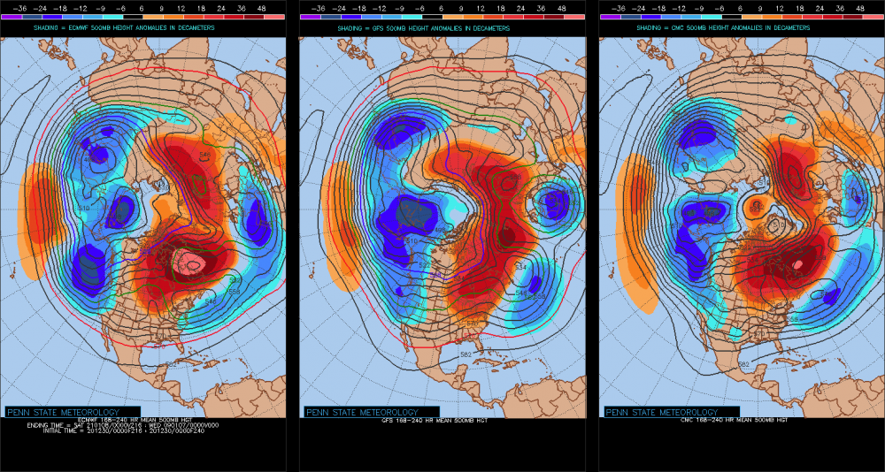
I have never seen this hemispheric layout before... It's almost a 2-wave rest state pattern. It just happens to have a couple nodes of ridging on the right, and troughing on the left to make it blurred, but that's about probably as close to a 2-wave structure as is mathematically possible given Earth geometry and mass-density/velocity ...
-
Significant upper middle Atlantic S/CNE mix/snow potential Jan 3+
Typhoon Tip replied to Typhoon Tip's topic in New England
'Course ... I will be the first to admit, 'live by the NAO die by the NAO' ... Not a huge personal fan of it as being as significantly 'forcing' - I still think a -NAO is equivalent to an "indirect Pacific" ...in that, the latter instructs the former, which then parlays in activity in that order ... but I don't wanna get beat up over it either . The 29th - if anyone recalls ... - had a promising look at D7 or so, but it too was contingent over the NAO's blossoming, which it was in the runs at that time.. But, every cycle immediately ensuing thereafter, gradually took more and more of the western oriented blocking off the charts .. until actually the opposite remained, and the 29th lost out in the shuffle... I dunno - it's a tough stochastic domain ... It's like the only field on Earth where the models can be wrong about a thousand*trillion tons of atmosphere in a single cycle ...massively changing its mode characteristic as a surgically intended strike on sanity ... heh Nah, but I think this has legs, this mode change.. that AO is dramatic and shares a large amount of NOA domain space.. Plus, this sort of concerts with the EPS previous NAO downward movement - it's been in the airs... -
Significant upper middle Atlantic S/CNE mix/snow potential Jan 3+
Typhoon Tip replied to Typhoon Tip's topic in New England
this run is behaving strangely .. It's trying to maintain the previous super-structure surrounding the advent of the NAO mode change throughout the D5-10 range of the run, but unlike prior solutions ...it keeps the 40 N train of waves moving at Maglev velocities ... That's buckin' for a progressive and retrograde pattern simultaneously - .. at least in concept. I'd be happier if this model would pick either rather than doing this ... -
Significant upper middle Atlantic S/CNE mix/snow potential Jan 3+
Typhoon Tip replied to Typhoon Tip's topic in New England
It may be the down stream handling of the flow ... It really appears to me like previous solution "force" an initially less than ideal S/W south, because of 'emerging' down stream blocking - like the former 'senses' the forcing ( previous runs ...) before it actually is there, and then it is ..and it makes sense that a vortex is situated between CC and NS... In this run, down stream delays just a bit and that delays the south suppression - But actually looking at this again .. .I think the impulse Will's noting there is being corrected perhaps too deep ...owing to what the Euro likes to do with S/W in this time range... and what that does is lifts the lead wave N...effectively detaching it from the baroclinic field along the MA --> weaker low in a marginal atmosphere heads this in the wrong direction. This run is mutable in my estimation - no worries... -
Significant upper middle Atlantic S/CNE mix/snow potential Jan 3+
Typhoon Tip replied to Typhoon Tip's topic in New England
sort of .. . That whole structure may be a snap shot en route to some destination ... That is probably true, because we "should be" seeing the N. Atln changes coming into emergence soon thereafter... anyway, that is a vague impression of a L/W axis out around 60 W or so, ... in terms of total wave spacing, it's in the ball-park.


