Typhoon Tip
-
Posts
44,568 -
Joined
-
Last visited
Content Type
Profiles
Blogs
Forums
American Weather
Media Demo
Store
Gallery
Everything posted by Typhoon Tip
-
Yeah ... like that Signer that slipped on stage next to Obama back in '13 ... and was completely mimicking how to sign-language for the hearing impaired and of course... since so few in attendance actually need or require that assistance, pretty much the whole press conference went down with this guy 'faking' The one or two deaf people are looking around scratching their head - I guess it would be the equivalent of us hearing this: " [0y89yh because -> AHFDHF when -8-87077- no sire fah;fhhhfd;sdh;f why! " Lol, like, there's some language in there somewhere, you know - man... that's like the funniest thing ever... If the guy wasn't a quack ... I mean was that like a streaker at a ball game. I wonder where that clown came from. It's not that far fetched to imagine a drunk college kid doing that on a goof or dare - hahaha
-
No one in here is completely objective, obviously. Don't have to delve deeply into any philosophy to see that no human being observing "reality" truly is. We're all perceiving, subsequently then evincing those perceptions along some tolerated spectrum of lesser lucidity. Having mused that, ... this engagement ? Ho my ... it has less to do with "analysis" of weather - but weather is just vehicle for affixing drama .. getting a 'kick' high - and when it is model dependent... It's not real.. artificial. ... short of experiencing that high, this becomes 'group support' - which is the real destination. Perhaps in some way that can be construed as "an analyst" - lol. I see where Scott's coming from in that arena. We've just been dealt a pretty significant 'personal' blow as winter Currier&Ives enthusiasts. He's smart ... he sets his coffee down and looks at some shit from over night and the first thing that pops to mind is, 'oh god here we go' and it pisses him off... Why? Not because someone spiked his 'Nog with vinegar - it's because it's a collective "soft" delusion ... People/J.Q. User and the tenor demos the delusion is being formulated, ...given time, solidification of that delusion into thinking it is real... Chris' pot-shot said it perfectly in snark the other day - and it was funny, because it was essentially true: '...people in here are more interested in a D7 storm on the models than they are seeing snow in air' This was never intended to be what/why these environmental prognostic tools were ever invented - it's an emergent aspect of the Internet era. I mean ..try to imagine your world 20 years ago, if you are old enough to have been cognizant of pre-Internet. But I digress -
-
That 00z GFS operational surface depiction is NOT struggling to get ice to N NJ and CT/RI ... Folks appear needing/seeking idealized model-positioning of features, but you're rarely going to get that in guidance... Doesn't work that way - and there are numerous ways to get a cold wedged or a "tuck jet" into position, early mid or late system gestation... The only real silver bullet synoptic arrangement there is, is having +PP N whilst a barographic layout featuring clear frontal position W -E S of HFD/PVD either prior to go live time or during for that matter. If you see that... Cold prevails. If waiting on model cycles for perfect 'high farther south', or 'cold front sufficiently cleared the area' first? You're waiting indefinitely ... You just need the tuck jet set up, ...nothing else. Those features, as were in that run cycle .. were all three, a-prior, education, and climo precedenced for generating that phenomenon, and whatever QPF pretty artistry is out there... toss anything that isn't ice and mix between Rt 2/Pike and snow and bee-bees N of that to however distance... and icing outside of urban island or sea shores down to EWR and interior/E of TTN S of the industrial park. Now... of course ... all this is rendered moot if it is proven to be true ... Scott's need to have every possible model since the invention of Lego's proves the only way to get to a wintry solution before the above can even take place... just sayin'
-
Keep in mind ... The CMC has a boundary layer warm biases at that range. Synoptically that’s going to have a 30 to 35 knot tuck jet funneling East of the White Mountains clear to Hartford Connecticut and that set up no question that’s all ice in the interior there ...as far as Northern New England yeah probably snow and bullets mixed in the northern 1/4 of that shield
-
Yeah I here you. Thing is… Each model is playing into their own biases right now which is typical of this range right in the middle range right there. The GFS is probably gonna be the first one to latch onto splitting the streams busting open affairs and turning it into a shred mess like this while the euro and Gspot tend to curve all flows in that range, Which tends them to hold these things together longer lifting bombs up into confluence Eu and G hold on too long GFS may bust open the ravioli too quick The head game is at either could be right or somewhere in between usually
-
Yeah a-heh. No .. if that sets up like that 144 chart ur icing to N NJ
-
‘ Remember posting that I thought it might do this on the 18 z ; it’s interesting it waited ... but anyway whatever I think that it’s possible this thing just keeps trending into either a flat snow event or some kind of ANA false hope… We may just be passing through the fun cycles bow on our right way to a flat solution I just can’t get over the speedy flow and I don’t know what’s going to slow this down ...really thread the needle this time. That’s is, for now
-
132 GFS looks interesting at 500 mb ..stronger with that polar jet over south and central and south eastern Canada which makes it a little bit interesting how it’s going to lift that Tennessee valley disturbance into that confluence like that
-
Neurotics Jan has about the same odds of being above(below) climo in snow
-
Is that a recent run tho - ...I've only recently caught wind of discussion that it's got better verification scores ( than many think ) ...so of course, that's when my source at Tropical Tits decides stop updating it. Their hung up on Dec 22, 00z
-
Yeah...no question ( Scott ) it was better oh.. 8 days back. We had the 29th, and it looked good, ..based upon the relative slowing of the 70 N band ...giving the hemisphere an implied cyclonic gist - that's an intrinsic constructive wave interference pattern as a canvas ..blah blah. what happens - ... every cycle since has been further and further from that same complexion. It's like we've seen three patterns: that one... then the shit in between, now there is a new semblance emerging perhaps last night into this morning.. Less conventional or 'mainstay' model types unraveling the multi stream phased look. I tell you one thing that's under the radar in all this.. That big Lakes cut and warm intrusion event over Xmas .. those types of cyclones have a climate signal for preceding -NAOs... It is interesting that the runs 8 days ago seem to suggest one - only to fail.
-
Lol, I think I've been agreeing with you over the last hour and didn't see your's/anyone else's posts.. I was just commenting that the GFS made a siggy whole scale change ...and I suspect we may be on the verge of just outright changing the landscape of that period of time... Dec 30 - ...I dunno the 4th... and it's not clear to me that whatever happens in there isn't multi staged, too... I could see this getting into a lull between type ordeal - ... These flat +PNAP flows that are fast... Really, the last thing was an anomaly relative to that to be honest. Almost consider this uncharted waters - I'd also encourage the tele user to pay attention to those annotations I made earlier - the AO/NAO are almost unusable presently at CPC
-
Watch... this 18z run will have that salmon stripe down to interior Mass -
-
Yeah, the more I look at that GFS... 6 hours sooner with the +PP building into/E ontario and it that air mass does an around and sets up an icing situation into CNE and probably tuck jet climo kicks in -
-
I thought the GFS actually leaned in favor of less full latitude too...interesting. In fact, if that 500 mb were to construct just a bit more confluence over Ontario, it's OV solution probably ends up underneath at the surface...
-
Oh, I've mused/lamented this more than a few times in recent years. It's the "cinema" of "weather charting" ... it has emerged endemic to the internet age. These modeling displays were never meant for this sort of general consumption by J.Q. En Masse. This and the engagement? It's an accident. I can't help but wonder if it is connected to some kind of persecution psychobabble - think about it... Folks have no control, and pine for the next run to rescue their mood? It really is almost no different than the circuitry of an abusive spousal relationship lol
-
Your ICON model joined the UKMET at 12z here... Thing is.. both avoid the full latitude trough expression... but they're signaling ice/ overrunning mix scenarios with that -
-
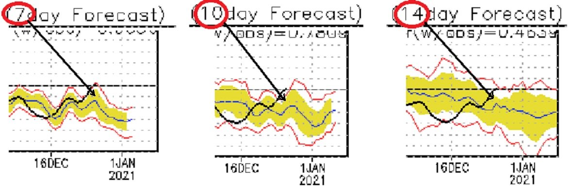
Really wish the CDC didn't go defunct processing these indices when the GFS' migrated to the expanded member ensemble system. When that took place there was no funding to recursively migrate the the core algorithms used to calculate the EOF system ... I was told by personnel at CDC that they did not know when any funding would be made available. Jesus, given to the tempo of the world affairs and judging by the Pandemic economy? good luck! It seems all these arms of the Government are destined to go to brown-out operatiions. Anyway, having multiple agencies assessing these indexes would do wonders to help in this situation. ...Something leaped out at me this morning that I had been negligent, and I suspect others have been too... or perhaps just didn't/don't know to consider: The AO prognostic intervals have become unusable - as their curves are off-line by too much to assume they have much deterministic value. All forecast intervals, D7, 10 and 14 ... The error is on the order of 2 SD (absolute value). I'm not sure if a "reset" of the system would fix this, or if it is more endemic/physical in the sense that the tech is what it is, and the atmosphere is just that complexly in a maelstrom. I have seen the system rebooted ( for lack of better words ...) in the past, but I am not sure what/why, or if just huge embarrassing gap control in the prog vs verification curve is ever a reason to do so... But either way, this is pretty bad folks, (note, the bold curve is the verification, and the other is ens. mean) That has grown GINORMOUS in error frankly, and given to the persistence and continued widening gap there... the prog's predictive use/value is almost meaningless at this point. The following statement may be more science fiction ...who knows, but with the Holiday season and an air of uncertainty et al the status of the world.. .one must wonder if there is anyone even there at the office over the last 10 days to address that glaring gap. I wouldn't trust the AO progs at CPC. Frankly, the NAO has a pretty bad error gap too - https://www.cpc.ncep.noaa.gov/products/precip/CWlink/pna/nao.sprd2.gif and I would almost argue that because the flow is fast overall, ... it may be skewing these indexes because it mimicks the negative phase state to have massive jet velocities S of them ...but the regions are not really in a blocking mode ... just a supposition. Either way, these verified patternization and embedded features, and the operational versions ... they are all actually not a terrible fit for the verification curves we see above, in so far as the GEFs are concerned... And I suspect the EPS system may also be faltering ...as I have seen the NAO progs from them and they seem to mimick the GEFs... and neither is performing -..in fact, the curves are parting company at a 45 deg.. gross.

-
The problem is that most people don’t know what the f they are talking about and think every warm pulse observed is of the same ilk as those that actually effect the PV ... They are not firstly that common tho. And yes ... propagation is apart ... If there was a bona fide event tomorrow .... the PV/ -AO ensues in 20 days. Per my own experience the consensus ... ~ half the people don’t even realize propagation is necessary, and of those only half over are even aware of the time lag between the onset of a warming event and the realization of a falling AO ... And yes ...which means that the AO can be forced to fall for other reasons that aren’t even related to SSWs ... such that it gets lost in the din of other ongoing hemispheric various modes so in that sense it probably is overused ...
-
That's one way to call it
-
that's a fascinating assertion actually ... I really had not considered the weighted mean as culprit "emerging" a less than physically plausible arrangement - but yeah.. Is that possible though - can the arithmetic cause a "synergistic" results, that don't happen at the single physical scale of a singular source/guidance member (component) ? I think it can ... See, each ensemble member is 'perturbed' - and by that we don't mean someone is going into the grid with a spoon and giving the mixture a swoosh and then running the model like 10 year old's might think ( lol ..). It means aspects like different convection initiation and sequencing ( for example ..) or different micro physical processes ...perhaps variant assimilation techniques ... etc, are built into a given individual member .. ...blah blah you know this I'm not preaching at you. It's for the general reader.. But, my point is, if a set of ensemble members is intrinsically invalid in a given pattern - or always - and is included in a mean, it's "essence" of implausibility would carry through and effect the mean - that's just basic math. Of course... but I wonder if doing so at the scale and scope of dizzying complexity that goes into these models, might cause huger fractals to emerge and synergize errors that are over the threshold of Terran geophysical likeliness... That's fascinating dude -
-
The problem is ... climate change has no direct advocate in the form of appealing to one's corporeal senses. Or if so, so passively it can be figuratively written off as just a weird, little forgettable curiosity that'll fail really to compete with the other more pressing urgencies of modernity. Because of this, it is 'insidious' ... expressing its self in nuances so subtle they are undetectable to common daily life.. Like, being still inside the warm sector ...east of a cold front, and the wind just abates. Not impossible... but rare. We should be kissing the WCB up against the baroclinic wall, where it's western mass in being lifted and peeled back into a quasi trowal - ... This? The WCB has escape and detached and gone away, and the fronts still 100 mi west. Is it "just figurative" to wonder if the warmer atmosphere has "room to spare" with surplussing? Probably... but, this thing doesn't even have a very strong lower troposhere cyclonic expression for all that massive mid level power over the lower OV ...whirling about. Yet, the -AO precedes is supposed to = not enough cold to excite steeper baroclinic gradients ... No one is going to notice that ..it's not even "knowable" really. Nuances? ..maybe. Autumn... and all the sugar maple trees felled their leafs a solid and quantifiable three weeks ahead of schedule. Who cared to notice, right ? ... But, counter to most people's intuitive understanding, the reason that happens - recently papered - was a surplus in growth potential met during the preceding summer. See...there is a limit to the amount of growth potential a species can achieve, and once that is reached, ... that has been recently found to be a key trigger in 'when' chloryph. leaves and flushing begins ... It just so happens, too, that it has always better coincided with the solar and cooling timing, respectively. Of course... Species evolved in constant solar cycle, and climate that allowed adaptation rates. But these warming summers exceed the latter, and combining that with a C02 thickening atmosphere ... enables ( ironically) the growth potential and maples .. they were flying in a fast jet and landed early All the snow has melted here on any flat surfaces around this bend of Rt 2, and in fact, a goodly 2/3rd of the curb side berm mass has vanished for this warm swash event... Yet the lawns and fields exposed? GREEN. ... no. Flora does not respond that quickly. The fact is, it was never gone into dormancy in the first place. We've just been though 10 days of neg departures, in which we laid down a foot to foot and half of snow... and had a few mornings in the single digits... Snow melts in 6 to 12 hours... green lawns. Who notices .. who cares. These are the idiosyncrasies that are "easily" explained .. thus dismissed, ..and the explanations are even clad. They really are... But, to the astute observer... they are still unusual, and the frequency of these 'under-the-radarisms' are increasing. That's how this works...
-
Christmas Eve/Day Annual Scrooger Event
Typhoon Tip replied to Baroclinic Zone's topic in New England
Im sure this has come up but ... does anyone know why the NWS changed public access radar displays - what’s their goal in doing this particular migration ?? -
That weak sauce ridgiing south of Greenland? A week ago the models had that as a better formed block. Faux NAO blocks go to nothing and now this operational GFS run goes all the way out of 7 January and there’s no sign across conus of any kind of -NAO climate flow whatsoever. I don’t know we just seem to have trouble with any standing NAO in the models and I think a lot of it has to do with velocity saturation in the general ambience of the whole circulation system. I mean it gets amazing to consider the AO It’s so negative… Yet it’s counterpart EPO and NAO domain spaces have trouble formulating blocking... at what point are peoples eyebrows going to raise hello. It appears we are suffering some kind of bizarre anomaly where the AO is very large like it’s going negative but it’s not weak despite collapsing south in latitude ; the flow around the terminus is still very strong and fast and it’s inherently going against curved surfaces so you can’t formulate blocking that way… Fascinating in a not so pleasing way
-
No argument from me ... Not sure about the transition/timing though. Guess that's typical. I'm just not ever trusting or confident in the handling of NAO formats for blocking. That has never been well handled ever ... period. at D7 ...let along 10. It's magnitude, and placement...have disparate verification that don't even appear to be dependent on one another. It could be -1... -3... while, west, neutral or easterly biased... No correlation with one another, and only poorly correlated to whatever mean/guidance ensemble system is sniffing, too. The -AO over-arching is where I side with the "blocking" ... The current AO sell at the GEFs store kicks-in around NYs ... with concerted plummet thereafter. The members run astray toward latter week 2, but for the most part stay negative. The mean appears pretty deep though - around neg 2 or even neg 3. That may be pulling the EPO and NAO's down more so than they are actually negative? Something to consider, because they share domain space in partiality. The operatoonal Euro and GFS .. thru D10 don't really look that negative up there ..they have a ridging, but it appears more subtropical in nature perhaps overlapping the lower domain lip of the NAO space. Not a bona fide -NAO look in the D7-10 for those... That' getting into the first week of Jan so.. I do wonder if the NAO part of this proves a sore butt red herring yet again... And the AO in conjunction with oscillations in the PNAP may parlay better. Either way, no one's gon' give a ratz ass if it's snow off either scenario. lol ...it's like okay, fine make the fugger happen.