Kevin Reilly
-
Posts
3,397 -
Joined
-
Last visited
Content Type
Profiles
Blogs
Forums
American Weather
Media Demo
Store
Gallery
Everything posted by Kevin Reilly
-
Picked up 0.17" yesterday power went out for about 2 minutes and windy with the thunderstorms, but we need a lot more than that it didn't even fill my rain barrel halfway. I was in Cinnaminson yesterday they got hit pretty good along Route 130 I would say winds 45-50 and picked up a quick .35-.50 or so.
-
highest here so far is 95f with a heat index of 101f. We have a bit of an issue too for sure with lack of rain really nothing coming either.
-

Invest 92L in SW Atlantic reached SE US Fri
Kevin Reilly replied to GaWx's topic in Tropical Headquarters
Yep, this is pretty much done. Northerly shear coming down from the upper air low to the north also dry air moving south-southwest quickly. -
Invest 92L in SW Atlantic reached SE US Fri
Kevin Reilly replied to GaWx's topic in Tropical Headquarters
Yea this has really caught my eye. Looks pretty good on the visible satellite you can clearly see a circulation. Looks like thunderstorms are trying to blow up on the west and northwest side of this circulation. If these storms can wrap around that center this will likely become Tropical Storm Beryl. I was looking at water vapor and it has a decent moisture envelope with it dry air shouldn't be a problem shear for now looks okay. Florida Satellite Weather Map | AccuWeather -
Tropical Storm Alberto--Mexico Landfall at 50mph/993mb
Kevin Reilly replied to WxWatcher007's topic in Tropical Headquarters
That has got to be the broadest circulation I have ever seen in my lifetime. Looks like there may be just a bit of southerly shear just to the west of the center. This has a limited chance to develop into anything much larger than a 45-mph tropical storm. However, weather affects will be far removed from the center especially on the north and northwest side. -
68f 93% humidity windy winds gusting 30-35 from the NNE assuming an outflow boundary. It is partly sunny with light rain and a rainbow to boot. 0.27" total rain
-
High here today was 93 we just had some heavy downpours picked up a quick 0.25 just really light rain now. I saw one weak lightning strike a few rumbles of thunder call it garden variety thundershowers with winds gusting to 25-30 mph. Currently: 70 humidity 84% dewpoint 65
-
Late Feb/March Medium/Long Range Discussion
Kevin Reilly replied to WinterWxLuvr's topic in Mid Atlantic
That looks exactly like the 12z GGEM -
E PA/NJ/DE Spring 2024 OBS/Discussion
Kevin Reilly replied to Hurricane Agnes's topic in Philadelphia Region
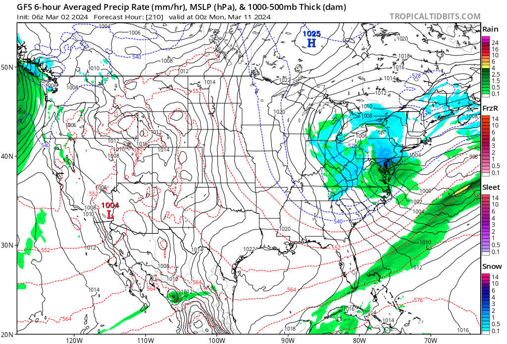
Storm total here in Media, Delaware County 3.00" on the button! Breezy now maybe winds gusting to 30 mph. Crum Creek just over its banks still rising a bit though. -
E PA/NJ/DE Spring 2024 OBS/Discussion
Kevin Reilly replied to Hurricane Agnes's topic in Philadelphia Region
Moderate to Heavy Rain 44f humidity 99% Dewpoint 44f pressure 29.63 steady wind east 2 mph. Total rainfall 2.57" -
Getting ridiculous is an understatement. High here today was 78f normal high here today is 52f low last night was 46f so yea well above normal. Normal High here 52f normal low 31f So, between the normal highs and lows were above by 41 degrees. Up here in southeastern PA we have all daffodils, saucer magnolias, southern magnolias, and brad ford pear trees, apple trees, and cherry trees in full bloom. Crocus are done as they bloomed in and around January 21st. We have had our daffodils in full bloom since Valentine's Day so there is that. Also, we had snow squalls and 50 mph winds last Saturday so yea it is changeable too. Anyone buying highs in the 30's next week on the GFS? That's a close call for snow on March 23rd up here in Southern PA. lol right.
-
Late Feb/March Medium/Long Range Discussion
Kevin Reilly replied to WinterWxLuvr's topic in Mid Atlantic
I would think the safe bet would be Lake Tahoe LOL..... I would pick that area. -
E PA/NJ/DE Spring 2024 OBS/Discussion
Kevin Reilly replied to Hurricane Agnes's topic in Philadelphia Region
Moderate Rain 47f humidity 99% dewpoint 47f wind east 14 mph pressure 30.13 steady Total rainfall: 1.20" and courting -
E PA/NJ/DE Winter 2023-2024 OBS/Discussion
Kevin Reilly replied to The Iceman's topic in Philadelphia Region
I suppose we need to watch this timeframe. I think this is Ralph's miracle storm from the other day. We Track!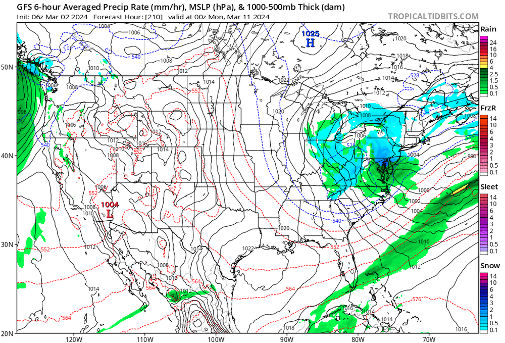
-
E PA/NJ/DE Winter 2023-2024 OBS/Discussion
Kevin Reilly replied to The Iceman's topic in Philadelphia Region
Alll normal everyday stuff no worries: 12 feet + of snow in Sierra Nevada after 5 Years of no snow Raging fires and 90 degrees + in Late February all normal stuff. Being Sarcastic obviously there is an obvious problem in climate in my opinion and most of it is fueled by warm ocean water temps and air temps especially the Pacific Ocean. -
Late Feb/March Medium/Long Range Discussion
Kevin Reilly replied to WinterWxLuvr's topic in Mid Atlantic
When you know you know! You know it is over when you see this! .BLIZZARD WARNING REMAINS IN EFFECT UNTIL 10 AM PST SUNDAY... * WHAT...Blizzard conditions likely, particularly through Saturday morning. There is a 10-20% chance of thunderstorms along the crest through this evening with snowfall rates of 4 to 6 inches per hour at times. Snow accumulations between 3 and 6 feet for Lake Tahoe communities, with 6 to 10 feet above 7000 feet. Winds gusting to 70 mph in lower elevations and above 115 mph over Sierra ridges with significant drifting of snow. * WHERE...Greater Lake Tahoe Area. * WHEN...Until 10 AM PST Sunday. * IMPACTS...Whiteout conditions with near zero visibility at times due to blowing snow. The strong winds and weight of snow on tree limbs may down power lines and could cause sporadic power outages. Travel will be treacherous and potentially life-threatening. PRECAUTIONARY/PREPAREDNESS ACTIONS... A Blizzard Warning means severe winter weather conditions are expected or occurring. Falling and blowing snow with strong winds are likely. This will lead to whiteout conditions, making travel extremely dangerous. Do not travel. If you must travel, have a winter survival kit with you. If you get stranded, stay in your vehicle. Downtown Truckee, CA Live Webcam | HDOnTap.com Take a trip anyone! LOL -
E PA/NJ/DE Winter 2023-2024 OBS/Discussion
Kevin Reilly replied to The Iceman's topic in Philadelphia Region
When you know you know! You know it is over when you see this! .BLIZZARD WARNING REMAINS IN EFFECT UNTIL 10 AM PST SUNDAY... * WHAT...Blizzard conditions likely, particularly through Saturday morning. There is a 10-20% chance of thunderstorms along the crest through this evening with snowfall rates of 4 to 6 inches per hour at times. Snow accumulations between 3 and 6 feet for Lake Tahoe communities, with 6 to 10 feet above 7000 feet. Winds gusting to 70 mph in lower elevations and above 115 mph over Sierra ridges with significant drifting of snow. * WHERE...Greater Lake Tahoe Area. * WHEN...Until 10 AM PST Sunday. * IMPACTS...Whiteout conditions with near zero visibility at times due to blowing snow. The strong winds and weight of snow on tree limbs may down power lines and could cause sporadic power outages. Travel will be treacherous and potentially life-threatening. PRECAUTIONARY/PREPAREDNESS ACTIONS... A Blizzard Warning means severe winter weather conditions are expected or occurring. Falling and blowing snow with strong winds are likely. This will lead to whiteout conditions, making travel extremely dangerous. Do not travel. If you must travel, have a winter survival kit with you. If you get stranded, stay in your vehicle. Downtown Truckee, CA Live Webcam | HDOnTap.com -
E PA/NJ/DE Winter 2023-2024 OBS/Discussion
Kevin Reilly replied to The Iceman's topic in Philadelphia Region
I give it a 1% chance of being on the next model run. -
E PA/NJ/DE Winter 2023-2024 OBS/Discussion
Kevin Reilly replied to The Iceman's topic in Philadelphia Region
Bring it!! March 1993!! -
E PA/NJ/DE Winter 2023-2024 OBS/Discussion
Kevin Reilly replied to The Iceman's topic in Philadelphia Region
Not sure it is much better there either they are way below normal snowfall and way above normal temps too and are adjacent to another warm body of water Lake Erie. -
E PA/NJ/DE Winter 2023-2024 OBS/Discussion
Kevin Reilly replied to The Iceman's topic in Philadelphia Region
Pretty Lucky with your death band the models did all they could to find the needle in the haystack! That event though has got to be your most memorable event over the past few years. I will say it was fun tracking that until 3 am and then hearing the results as I looked at bare grounds until 1 am. -
E PA/NJ/DE Winter 2023-2024 OBS/Discussion
Kevin Reilly replied to The Iceman's topic in Philadelphia Region
Above you're right Winter is Over with that look! Here come the 60's, 70's possibly 80's. I fear for NYC to Boston Drought pending!
-
E PA/NJ/DE Winter 2023-2024 OBS/Discussion
Kevin Reilly replied to The Iceman's topic in Philadelphia Region
Yea pretty much snow wise better than last year, but we got lucky. The results are pretty much the same just a slightly different way to get there. Temps will wind up above normal again and below normal snowfall most areas except the snow capitol of the east Allentown. -
E PA/NJ/DE Winter 2023-2024 OBS/Discussion
Kevin Reilly replied to The Iceman's topic in Philadelphia Region
Outside of shaded areas we are back to zero. However, the shaded areas look like a solid 3" still. -
E PA/NJ/DE Winter 2023-2024 OBS/Discussion
Kevin Reilly replied to The Iceman's topic in Philadelphia Region
And it shows how warm the Great Lakes are.