GaWx
-
Posts
19,003 -
Joined
Content Type
Profiles
Blogs
Forums
American Weather
Media Demo
Store
Gallery
Everything posted by GaWx
-
Don, Keep in mind (which I assume you are) that this very warm CFS Feb map is taking into account the first half of the month being forecasted to be much warmer than normal from the Midwest to the NE. The 2nd half, which I know you alluded to, is forecasted by the same model to be much colder than that in those areas but not cold enough (as of the latest) to keep the Feb average from ending up AN in NYC.
-
January Medium-Long Range Discussion
GaWx replied to Holston_River_Rambler's topic in Tennessee Valley
Mid Feb is still plenty early enough to potentially result in a several week long period dominated by cold and periods of wintry precip, which has occurred in the SE US during a good number of El Ninos. The extended models are targeting the 3 weeks from mid Feb through early Mar. -
January Medium-Long Range Discussion
GaWx replied to Holston_River_Rambler's topic in Tennessee Valley
Thanks for posting this. I need to also add that the maps I posted are for all ENSO rather than just El Niño, which itself tends to have lower heights in the S US especially in Feb. -
Thank you! Where can I sign up for this that just came out from the newest 48 CFS run mean for mid Feb (Feb 13-19)? It has -EPO, +PNA, -AO, -NAO, and the very important and sometimes overlooked split flow (moist subtropical jet underneath and overrunning the bottom of the cold air supply from +PNA) with a good moisture source coming across from Baja CA. This pattern should it materialize would favor any Arctic high to move from the N Plains to near the Ohio Valley as opposed to the colder but drier option of plunging down into the S Plains. What more could one want in terms of overall pattern for SE winter storm potential other than needing to be patient since it would take ~3 weeks to get established? By the way, that timeframe continues to move up as it was 4+ weeks away when I first started seeing it on the extended models over a week ago.
-
January Medium-Long Range Discussion
GaWx replied to Holston_River_Rambler's topic in Tennessee Valley
This is from NOAA fwiw for JFM averaged out for temperatures: phase 7 near normal to temperatures (within 2F) but that’s for those three months combined and also aren’t heights: -
January Medium-Long Range Discussion
GaWx replied to Holston_River_Rambler's topic in Tennessee Valley
http://www.bom.gov.au/climate/mjo/ -
As one who lives near the coast, I sure hope Matt is right! Also, El Niño late Februarys and Marches tend to be cold/BN in the SE. That would hopefully keep the GOM temps in check at least at first.
-
January Medium-Long Range Discussion
GaWx replied to Holston_River_Rambler's topic in Tennessee Valley
I can’t take credit for the phase 7 snow analysis. I believe that was from Eric Webb and specifically was addressing NC, possibly only at Raleigh. Also, I can’t recall whether or not Eric was looking only at El Niño cases. My big thing in recent years of MJO analyses for the SE has been to harp on the tendency for cold and wintry wx to favor weak MJO: just outside, near, or inside the circle. For example, off the top of my head I recall discovering that every major ATL ZR and IP (as far back as MJO charts go, which is mid 1970s) has been when the MJO was weak. I’m sure that streak will end at some point as the sample size isn’t large (I think it is only 8), but OTOH it makes sense that it would favor weak since weak tends to be colder than strong. Also, I wasn’t looking specifically at the TN Valley, which may be quite different. -
12Z GFS still has only 6 mild to warm afternoons in NC: Jan 24-28 and Feb 2 out of 16 days. Also, 4 afternoons are actually cold. And this is well before the modeled/supposed good stuff starts after Feb 10, which hopefully would start showing up near the end of the 15-16 day ensemble runs by this weekend. That’s been the timeframe for that for many days. I’ve been posting about this extended model based potential for ~10 days. No slippage yet.
-
I’m roughly estimating that the Jan 2024 SOI will end up in the +3 to +5 range. How would that compare to other strong+ Ninos? I count 18 of them going back to 1877-8. Out of these 18, 17 had a -SOI in Jan. The only one that didn’t was 1931’s +6. So, Jan of 2024 is headed toward easily having the 2nd most +SOI of 19 strong+ Ninos and not far behind 1931. Unlike 2023-4, 1930-1 was unusually dry in the E US for El Niño. Regarding just the 6 super Ninos, their Jan SOI range was from the -4 of 1973 to the -31 of 1983. https://data.longpaddock.qld.gov.au/SeasonalClimateOutlook/SouthernOscillationIndex/SOIDataFiles/MonthlySOIPhase1887-1989Base.txt
-
After topping in Nov (fairly typical timing of a top), the OHC is already 0.9 lower than where it was then and is at its lowest since way back in early March of 2023 with it only near +0.6:
-
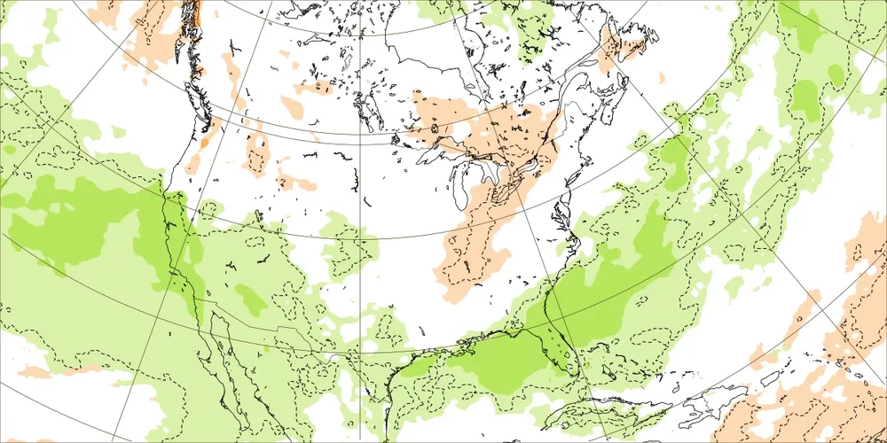
Is this good? To give an idea of how much extra moisture this represents thanks to the subtropical jet, @pcbjr’s abode of Hogtown, FL, is shown getting almost double its normal rainfall for Feb 13-19. Normal is 0.64” and this suggests ~1.20” of qpf along with cold air lurking to the north. It suggests ~1.25” at ATL since normals are much higher there and in other areas of the heart of the SE. The qpf in most of the SE is 1”+. Split flow ftw? At least the ducks are on the pond and it’s mid-Feb during El Niño. Get the right timed mix and look out SE.
-
18Z GFS, like the 12Z, also has only ~5 truly mild to warm days in the bulk of the SE through the entire run. As a bonus, it like the 12Z has generous (~3-5”) upslope snow in W NC along the TN border.
-
The latest 48 member CFS ens (4 member x 12 runs through 6Z on 1/22) stays the course for most of Feb in the SE with a -AO, Aleutian trough/+PNA, BN H5 hts, and a wet Gulf low favoring subtropical flow (split flow in combo with the +PNA) all combining for plenty of potential for especially mid Feb through early Mar. This run actually lowers H5 earlier.
-
Even though the 12Z GEFS doesn't have the cold of the 12Z GFS, even it has a period of pretty close to normal in much of the SE US Jan 29-Feb 2. So, a break in the warmth over most of the SE is quite likely around then, whether it includes actual BN cold or not. I’d actually bet on a couple of BN days for many as ensemble means smooth out daily anomalies due to timing differences of members.
-
There's been a short break in the mild pattern in the SE that has been suggested for a good number of days of runs for near the end of Jan/start of Feb in between mild periods lasting ~one week prior and one week+ afterward. So, the earlier idea of 3 weeks in a row of solid warmth was exaggerated by whomever was saying that imo. But the 12Z GFS has only ~5 days of warmth on the entire run...a pretty significant outlier vs other runs. Though not betting on it, I hope it happens. Keep the warmth away as much as possible as we have enough of it at other times of year.
-
Indeed. After getting mild, the 12Z GFS has no warmth for over a full week, Jan 29-Feb 5+. Plus a wedge may follow. That would be longer than the mild ~5 days preceding it. Of course, fwiw since it is the wild swinging op GFS.
-
Very interesting post as it is backed by a good sized sample of real data. The results makes sense because USUALLY the cold needs to get there in advance for a BIG snow as opposed to the cold chasing moisture/rain change to snow scenario for which usually it dries out too quickly. But this also shows that it is best that the cold not come in too far in advance or else there’s a rapidly increasing staleness risk since cold in the SE usually modifies quickly/850s rise above 0C. Because 1982 was so extremely cold in advance, it had an extra day or so of time before 850s got too warm for snow.
-
I’m already down to 29.9 at 10:45 PM vs 31.5 two hours later last night. The forecasted low is several degrees warmer than last night’s low, in the upper 20s. So, it is already there. Well see how this ends up. Edit: That 29.9 ended up being close to the low of the night as it warmed back up the low 30s soon after with a wind shift to light NE.
-
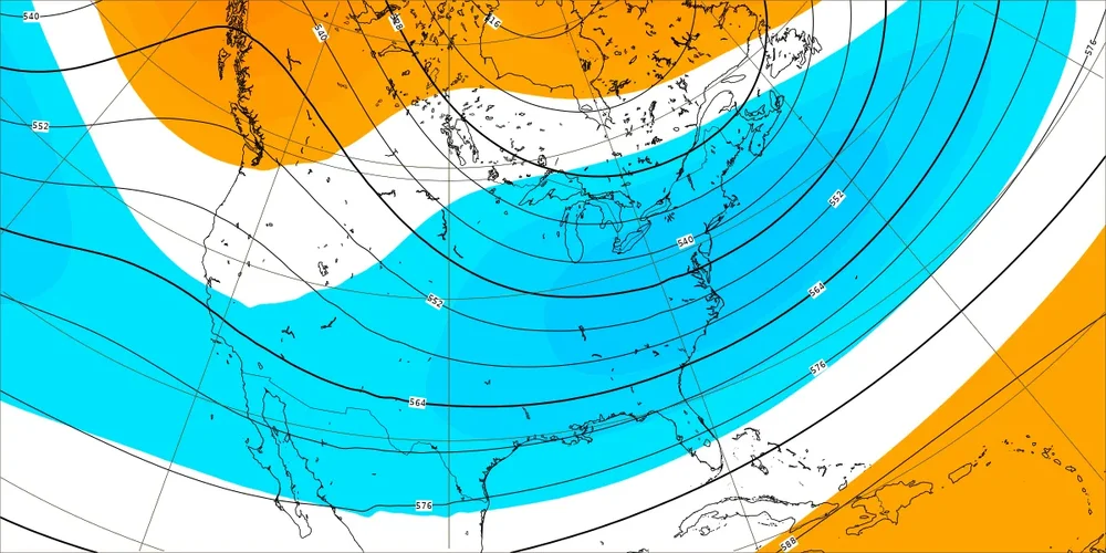
The new extended GEFS (0Z 1/21) is still another ensemble run that looks to me to be loaded with potential, especially for 2/15-23. There are many members with Arctic surface highs with centers that later cross near or just S of the Ohio Valley while sfc lows cross the GOM with plentiful moisture as can be seen here, all consistent with a split flow of +PNA/strong subtropical jet (thank you El Niño) accompanied by a solid -AO and developing -NAO: The Euro Weeklies, extended GEFS, and CFS ensemble keep on giving me lots of hope for the period 3-5 weeks from now. They’re not at all stopping as we slowly get closer. If these keep up, we’ll start seeing the start of this favorable period getting into the 15-16 day ensembles around this weekend. *Corrected for typo to 3-5 weeks from now
-
These Euro Weekly maps of today are subtly moving up the timeframe. The 3 main extended ensembles as a whole had been suggesting a little bit later in Feb as the start of the best shot but todays Euro is saying that near or just before Feb 15th could end up being the start of good opportunities.
-
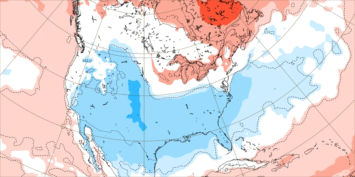
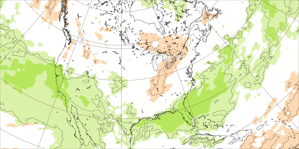
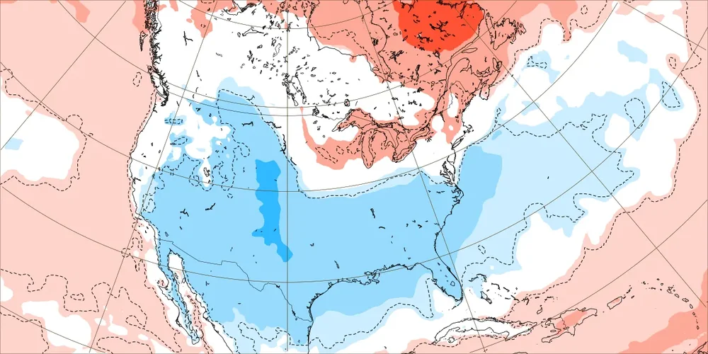
New Euro Weeklies for Feb 12-19: Does this look at all like winter is over in the SE? Not to me unless we’re playing the game of opposites. H5 hts are lowest of any run so far in SE and also suggests split flow with both a +PNA and BN hts from S CA/Baja eastward typically associated with moist subtropical jet: Easily both the strongest and also most widespread BN temperature signal yet by far and it has been getting progressively colder: Check out the wet subtropical flow from S CA/Baja into SW US/MX and then over N GOM/Gulf coast/S GA/S SC to NC coast and offshore SE US with all of the SE near to wetter than normal: This combo of maps is suggesting an El Niño induced GOM Miller A mixing with widespread cold that would be a near perfect setup for a widespread major SE winter storm near the most favorable climo for it (moderate or stronger Nino in mid Feb). I couldn’t have drawn week 4 maps any better than these to suggest such potential. Now whether or not these maps are matching anything likely even close to what will happen is probably something worth discussing as they are after all out at week 4. But I’d much rather see them than not! And the same ideas keep showing up starting around this period.
-
Only 41.3 at my place probably near the high of the day at 3:50PM. Highest at most likely no more than ~42. Easily the coldest high of the winter to date.
-
You’re welcome. If you mean snowiest in the US as a whole, I don’t know. How would that be determined? I imagine it would be subjective. Also, keep in mind the changing US boundaries. And if you wanted to go back before 1776, that would be interesting but of course there was no US yet and the account locations would be more limited the further back one goes. If I were you, I’d try to find and/or buy the two Ludlum books, which go back to 1604!
-
I don’t know about NYC, but I have seen accounts (as opposed to official records) of snowfall back that far and even much earlier (back into the 1700s) at both Savannah and Charleston. For example, the heaviest snow at Savannah by far, 18”, occurred late Jan 9 through early Jan 11, 1800! Charleston got 10” and even the GA/NE FL border near St. Mary’s got 5”! I’m almost sure that I didn’t learn about this incredible storm til after 2000. Without the internet, I might still not know about it.@donsutherland1posted about this truly amazing event before and he may have been how I first found out about it. It is in one of David Ludlum’s great US winter wx history books that Don cited. I don’t recall whether @SACRUShas posted about it. Edit: yes, @SACRUSdid in this post and very likely others: Edit: Look for David Ludlum’s two fantastic US winter history books at the library. I found them at my local public library. Here’s one you can buy, volume 2: https://www.amazon.com/American-Winters-1821-1870-History-Weather/dp/0933876246 Volume 1: https://www.google.com/books/edition/Early_American_Winters_1604_1820/6iNRAAAAMAAJ?hl=en