-
Posts
4,734 -
Joined
-
Last visited
Content Type
Profiles
Blogs
Forums
American Weather
Media Demo
Store
Gallery
Everything posted by Windspeed
-
Major Hurricane Melissa - 892mb - 185mph Jamaica landfall
Windspeed replied to GaWx's topic in Tropical Headquarters
Perhaps.They're definitely en route again based on flight path now. -

Major Hurricane Melissa - 892mb - 185mph Jamaica landfall
Windspeed replied to GaWx's topic in Tropical Headquarters
Given what ADT is cranking out, if Melissa maintains this appearance through the 5AM, it may still get the upgrade. Conservative estimates are still >140 kts. -

Major Hurricane Melissa - 892mb - 185mph Jamaica landfall
Windspeed replied to GaWx's topic in Tropical Headquarters
And here I was just talking about mechanical issues with recon and Eta's peak. History repeating itself. Damn... -

Major Hurricane Melissa - 892mb - 185mph Jamaica landfall
Windspeed replied to GaWx's topic in Tropical Headquarters
Recon just made a 180. Hrmm... -

Major Hurricane Melissa - 892mb - 185mph Jamaica landfall
Windspeed replied to GaWx's topic in Tropical Headquarters
Granted, Melissa's ADT is stronger than ETA's ever was. Eta got down to around 912 hPa on ADT, but recon found it to be 10 mb higher. Thus, it never achieved Cat 5 officially. Eta was also embedded inside of a WCARIB surface trough. Melissa's pressure regime is a little higher. So if it is indeed found by recon to be pushing the 910s or 900s hPa tonight, the gradient should support 140+ kt surface winds. But, yes, it would be surprising if ADT busted that hard again. Edit: I revisited Eta's estimates. It had a raw ADT of 8.0 and 7.0 blend at 912 hPa. But recon found 922 hPa when they finally arrived. The previous recon mission had mechanical problems, and the next mission may have missed peak. Also, we need to keep in mind that it is late October. The tropopause is a little lower even at a low latitude, and cloud tops can get a little colder on IR. So, dvorak satellite estimate algorithm can overdo the raw T numbers. Though I will always argue Eta should have been a Category 5 on reanalysis. -

Major Hurricane Melissa - 892mb - 185mph Jamaica landfall
Windspeed replied to GaWx's topic in Tropical Headquarters
Seeing a classic example of what deep oceanic heat content can support. Melissa has been barely moving the past six hours. More or less a drift W-WSW with wobbles. Yet the satellite presentation has continued to improve. The eyewall is cooling the immediate shallow layer, but instead of upwelling driving down heat support, upwelling is mixing up water that is still above the threshold to support Melissa's MPI. The 26°C isotherm is very deep in this part of the Atlantic. Somewhere between 100 and 150 meters. Interestingly, if Melissa did remain stalled for several days, it would eventually cool and mix down SSTs enough to begin impeding its MPI, and would eventually start to weaken. Unfortunately, timing is such with the trough to begin lifting Melissa's core north back over untapped deep OHC. So I don't think SSTs are going to be a caveat for a powerful TC weakening into landfall. We'll have to look at other dynamics for such, like the onset of fast ERC or structural changes. In other words, Melissa may still have enough time to attain Category 5 status and make landfall as a Category 4. But the differences here are pretty moot points. Despite the potential devastation at the location of landfall for the eye, the still bigger life-threatening event here remains the incredible rainfall totals over the south sloping ridges of Jamaica. Landslides and mudflows are killers. -

Major Hurricane Melissa - 892mb - 185mph Jamaica landfall
Windspeed replied to GaWx's topic in Tropical Headquarters
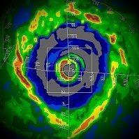
Most recent long-range radar image. -

Major Hurricane Melissa - 892mb - 185mph Jamaica landfall
Windspeed replied to GaWx's topic in Tropical Headquarters
No, they didn't get ahead of themselves. Their discussion followed ADT. Without reconnaissance data, you use what you have access to. Obviously, satellite isn't always as accurate, but it's usually close. Structurally, Melissa looks to be intensifying based on remote sensing data. But recon shows it's a little behind satellite trends. Visually, I don't think anyone would argue that Melissa looks like an intensifying Category 4. I don't think it will matter by this afternoon, regardless. -

Major Hurricane Melissa - 892mb - 185mph Jamaica landfall
Windspeed replied to GaWx's topic in Tropical Headquarters
That was a NW to SE pass. I'd imagine the NE quadrant isn't too far off from ADT. Also, the pressure is still dropping, and there is a bit of lag time. It is good we have recon out there at present because I'd expect to see continued signs of intensification on the next four passes for the mission. -

Major Hurricane Melissa - 892mb - 185mph Jamaica landfall
Windspeed replied to GaWx's topic in Tropical Headquarters
Melissa's eye is clearing out fast now. -

Major Hurricane Melissa - 892mb - 185mph Jamaica landfall
Windspeed replied to GaWx's topic in Tropical Headquarters
Mesovorticies rotating around the eyewall. it shouldn't be long until we start seeing pressure dropping like a rock. -

Major Hurricane Melissa - 892mb - 185mph Jamaica landfall
Windspeed replied to GaWx's topic in Tropical Headquarters
Here's some heat content and isotherm depth maps as well. Melissa's core, despite being a slow-mover, has plenty of energy to tap prior to land interaction. Credit to RSMAS at Miami for maintaining these to the public. -

Major Hurricane Melissa - 892mb - 185mph Jamaica landfall
Windspeed replied to GaWx's topic in Tropical Headquarters
Fourteen hours between those two images is absolutely absurd. We kept harping that all forecast indicators were showing substantial decrease in wind shear to a near to pristine favorable upper environment. The system is now positioned right under an amplifying ULAC. Powder keg stuff. I think we'll see a Category 5 today. -

Major Hurricane Melissa - 892mb - 185mph Jamaica landfall
Windspeed replied to GaWx's topic in Tropical Headquarters
Intense VHT is now going up in the NE eyewall. Obviously, we're in an ongoing rapid intensification phase. Expect some beefy pressure drops between now and Sunday afternoon with such an eyewall presentation on radar, which is getting more and more symmetrical each passing hour. -

Major Hurricane Melissa - 892mb - 185mph Jamaica landfall
Windspeed replied to GaWx's topic in Tropical Headquarters
OHC is very deep in that part of the Caribbean. The 26°C isotherm is over 100 meters of depth. It would take a multi-day stall before upwelling became a significant factor, and we're talking in terms of a Category 5 sustaining itself. For all practical purposes, the main reason even slow-moving hurricanes in the western Caribbean can maintain Cat 5 intensity well into November. Some of our most powerful historical Cat 5s were slow movers in that part of the world (Wilma, Mitch, etc.). It's where the Western Hemisphere's version of WPAC typhoons can occur, though still considerably rare. -

Major Hurricane Melissa - 892mb - 185mph Jamaica landfall
Windspeed replied to GaWx's topic in Tropical Headquarters
Unfortunately, with atmospheric conditions progressively becoming more favorable with each passing hour, I do not see a scenario where Melissa does not efficiently achieve its MPI. Land interaction or internal structural changes are the only limiting factors until it's picked up by the trough in a few days. -

Major Hurricane Melissa - 892mb - 185mph Jamaica landfall
Windspeed replied to GaWx's topic in Tropical Headquarters
Shear is modeled to relax significantly. There may still be some light mid-level shear, but not enough to prevent a major hurricane given other environmental features. The real key here is the eventual position of the center when the steering currents change. Land interaction will be the only significant deterrent to high-end intensity, such as where Melissa is positioned when it begins the slow turn north. Upwelling isn't going to be much of a factor until it has already reached MPI, if Melissa goes through a stall or slow crawl during its northward turn, as OHC is deep in that part of the Caribbean. -

Major Hurricane Melissa - 892mb - 185mph Jamaica landfall
Windspeed replied to GaWx's topic in Tropical Headquarters
The HAFS suite shows just how dire the slow recurve scenario would be with regards to a catastrophic flooding / mudslide scenario. The general wind and pressure intensities may be overdone, but the amount of rainfall will be extreme regardless. -

Major Hurricane Melissa - 892mb - 185mph Jamaica landfall
Windspeed replied to GaWx's topic in Tropical Headquarters
Given the slow recurve motion, Jamaica is facing a catastrophic flooding and mudslide situation. -
Yeah, Gabrielle is cranking. Should help a little with the low seasonal ACE numbers if it can hold onto major hurricane status for a few days.
-
High risk now...
-
I saw this interesting thread pertaining to the Chattanooga area this evening and boundary in place. https://bsky.app/profile/chattwjonathan.bsky.social/post/3lkgjvldr5s2g
-

2025 Atlantic Hurricane Season
Windspeed replied to BarryStantonGBP's topic in Tropical Headquarters
Yeah, I wasn't aware of a Main Forum thread to cover all the firings and potential dismantling of NOAA, etc., when I posted the news. I had just seen Andy got fired, was shocked, and understanding how we share his critical information so frequently (almost daily during the season), thought it of utmost importance to post here. Numerous critical personnel we rely on in these tropical threads have been terminated, some of which were not probationary due to being new hires, having had promotions or clearance level changes. I don't know how else we could avoid sharing these firings specifically in this particular thread since we post their work verbatim so often. This "situation" will clearly have impacts our pre-seasonal and active seasonal discussion as their analysis may not even be available. Though I did make my brief opinion known in the initial post, I will not delete it, and these additional comments are merely stating obvious impacts for our future discussions from an empirical standpoint. I will say no further. -

2025 Atlantic Hurricane Season
Windspeed replied to BarryStantonGBP's topic in Tropical Headquarters
https://www.nbcmiami.com/news/local/noaa-employees-laid-off-in-doge-cuts/3555471/ Pathetic. -
It's straight ripping fatties in Bristol. Column must be cooling off fast. Ground is already white. Surfaces are sticking. I agree with the above about the ground temps still being below freezing from the past week of bitter cold temps. Air temperature is currently 34°F here.

