cstrunk
-
Posts
608 -
Joined
-
Last visited
Content Type
Profiles
Blogs
Forums
American Weather
Media Demo
Store
Gallery
Everything posted by cstrunk
-
NWS observations for Longview still shows us at 40F. But it sure feels a lot closer to 32F IMO... Thundershowers moving through now.
-
Cancelled now...
-
I'm going to have to keep my faucets on steady drip/stream when I leave Thursday and return Monday... If that's even possible. I'm trying to travel to SW IA on Thursday and return to NE TX on Monday... With these trends I'm not sure if that will be possible..
-

Texas/New Mexico/Louisiana/Mexico Obs And Discussion Thread Part 8
cstrunk replied to wxmx's topic in Central/Western States
Sigh. -
Texas/New Mexico/Louisiana/Mexico Obs And Discussion Thread Part 8
cstrunk replied to wxmx's topic in Central/Western States
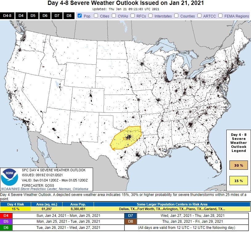
SPC has added much of northern TX and a portion of southeast OK to a 15% Day 4 risk area. I guess if we can't have winter, we might as well have storms! The dreary rainy/misty/cloudy days this week are not much fun.
-
Texas/New Mexico/Louisiana/Mexico Obs And Discussion Thread Part 8
cstrunk replied to wxmx's topic in Central/Western States
A little over 2" in Longview, TX.
-
About 1.5" in Longview, TX!
-
Texas/New Mexico/Louisiana/Mexico Obs And Discussion Thread Part 8
cstrunk replied to wxmx's topic in Central/Western States
Severe weather in deep east TX and central/southern LA may be more interesting on Thursday. -
Texas/New Mexico/Louisiana/Mexico Obs And Discussion Thread Part 8
cstrunk replied to wxmx's topic in Central/Western States
Very boring weather pattern. But it has been outstanding fall weather. Looks to be in the 70's for the next week. Only a slight chance of rain early next week but doesn't look like it will amount to much. When will it change? GFS says there could be a few chances for some precip over the next 16 days, but mostly only for the eastern half of the state. Nothing looks very significant/widespread. Texas could use some moisture. -
899 mb, 160 kt
-
Texas/New Mexico/Louisiana/Mexico Obs And Discussion Thread Part 8
cstrunk replied to wxmx's topic in Central/Western States
Yep, 36F here this morning. Had a new HVAC system into this summer. The heat wouldn't turn on yesterday. Luckily they were able to send a tech out and it was only a connection that wasn't plugged in. -
That's a full blown Dyson right there. Beautiful.
-
Texas/New Mexico/Louisiana/Mexico Obs And Discussion Thread Part 8
cstrunk replied to wxmx's topic in Central/Western States
39F was chilly on my way into work this morning. -
OKC sitting at 29F with quite a bit of precip overhead... how's that treating y'all up there??
-
Hello, Gamma.
-
Texas/New Mexico/Louisiana/Mexico Obs And Discussion Thread Part 8
cstrunk replied to wxmx's topic in Central/Western States
The last couple of days have felt great! Cooler and drier air. Looks like we could be in line for 3-4" of rain over the next few days from TS Beta. -
Texas/New Mexico/Louisiana/Mexico Obs And Discussion Thread Part 8
cstrunk replied to wxmx's topic in Central/Western States
Didn't get much cooldown here last week. Stayed in the mid-80's for highs and was still pretty humid. The mornings did feel much better! Been pretty dry since the early month deluge. Only 0.1" or less a few days ago. May have to start watering the lawn again. -
Texas/New Mexico/Louisiana/Mexico Obs And Discussion Thread Part 8
cstrunk replied to wxmx's topic in Central/Western States
So much for the mid-late week cool-down. -
Texas/New Mexico/Louisiana/Mexico Obs And Discussion Thread Part 8
cstrunk replied to wxmx's topic in Central/Western States
I've had 7.5" of rain at my house in Longview in the last week. Insane. 0.4" from Laura last Thursday 0.45" Saturday night 0.7" Tuesday 1.5" Wednesday morning 4.5" this morning (Thursday) -
Texas/New Mexico/Louisiana/Mexico Obs And Discussion Thread Part 8
cstrunk replied to wxmx's topic in Central/Western States
Got a bit of a surprise line of storms in NE TX late Saturday night. It was falling apart by the time it made it to my house (imagine that), but I still ended up with about 0.45" rain. A lot of rain is forecast over the next few days for much of northern Texas and southern Oklahoma. I'm right on the edge of it - where storms will either stay just west and north of me or will fall apart as they make it here. But several models today showed 2-3"+ for Longview so we shall see, it will be close. -
Texas/New Mexico/Louisiana/Mexico Obs And Discussion Thread Part 8
cstrunk replied to wxmx's topic in Central/Western States
The track shifting east really eased the impacts in Longview. 35 mph gusts and only 0.40" of rain at my house. Glad I ended up with anything at all, 10 miles west of here they got zilch. 10 miles east of here they got over an inch and much more if you keep going. -
Texas/New Mexico/Louisiana/Mexico Obs And Discussion Thread Part 8
cstrunk replied to wxmx's topic in Central/Western States
Looks like the west trend of Laura's track has halted and the trend is starting slightly nudge back east. Landfall still expected around the TX/LA border, give or take. Still have a day or a little more to some slight changes but the track seems pretty consistent. If anything I wouldn't be surprised to see it end up east of the latest NHC track, depending on the intensity tomorrow. It's a weird feeling here for me in Longview, I was excited for the prospects of some severe weather but not necessarily prepared for the center of a hurricane to pass over us. We're in a Tropical Storm Warning now, but I'll be surprised if we have much, if any sustained wind over 40 mph. In fact, the forecast from NWS Shreveport is saying 20-30 mph winds with gusts to 45 mph. That seems more like a spring day in the plains, to me. (Except 45 mph gusts here could cause a few more power issues with falling limbs and such.) Any more east shifting with the track is also going to start to reduce the predicted 2-4" of rain totals at my location too. As of now I would be very thrilled with 2", but I'm starting to think it may end up more like 1" generally. Of course it will depend on where Laura's squalls end up and where the rainfall bands set up. But being on the west side is usually not the place for a ton of rain or wind. -
Texas/New Mexico/Louisiana/Mexico Obs And Discussion Thread Part 8
cstrunk replied to wxmx's topic in Central/Western States
Looks like it's about to get interesting around here with Laura popping into the GoM now... -
Texas/New Mexico/Louisiana/Mexico Obs And Discussion Thread Part 8
cstrunk replied to wxmx's topic in Central/Western States
Obviously not a lot to talk about. It's been dry here for a couple of weeks. Some area have been lucky. SW AR had 4"-8" the other day. The MCS's that have tried to build toward my area of the I-20 corridor in East Texas have fizzled. Finally seeing 100 degree temps. Cold front on Sunday/Monday looks to bump temps back into the low 90's with only a very slight chance of rain. Needless to say I've begun watering my lawn! -
Texas/New Mexico/Louisiana/Mexico Obs And Discussion Thread Part 8
cstrunk replied to wxmx's topic in Central/Western States
No rain last week and nothing in the forecast for this week. The real summer has finally arrived. Highs forecast in the upper 90's. Guess it's time to break out the sprinkler!