cstrunk
-
Posts
608 -
Joined
-
Last visited
Content Type
Profiles
Blogs
Forums
American Weather
Media Demo
Store
Gallery
Everything posted by cstrunk
-
Big ol ETX bust is what I see.
-
Grunge-fest in progress along and east of I-35. We'll see how the activity reacts to the strengthening wind profiles into the evening.
-
The East Texas and Louisiana threat looks pretty dang messy and will be in questionable to poor chase terrain. The extreme NW Texas threat looks like a pretty good bet to at least see 2-3 isolated supercells. The tornado threat may be a tad bit lower but from a storm chasing perspective, that's where I would target.
-

Texas/New Mexico/Louisiana/Mexico Obs And Discussion Thread Part 8
cstrunk replied to wxmx's topic in Central/Western States
3.76" of rain over the last week has been nice since models had been showing quite a bit less. Hopefully the rest of Texas is cashing in, or can sooner rather than later. -
Central/Western Medium-Long Range Discussion
cstrunk replied to andyhb's topic in Central/Western States
There may also be some action in the central plains towards the last few days in April. -
Central/Western Medium-Long Range Discussion
cstrunk replied to andyhb's topic in Central/Western States
06z GFS is showing potential for the 4/23-4/28 timeframe. -
I guess they decided that the Euro wasn't the model to follow after all (or maybe the Euro caved)? This update lines up with what the NAM and HRRR are showing.
-
Latest HRRR, NAM 3K NEST, and GFS don't seem to support the threat around DFW and southward. Mostly seems to develop a MCS in SE OK that bows southeast overnight.
-
Well, it still seems like there could be substantial severe weather in OK/TX/AR/LA. So this would be the place for that in my opinion.
-
Well today looks like an Enhanced Bust.
-
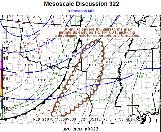
Mesoscale Discussion 0322 NWS Storm Prediction Center Norman OK 1110 AM CDT Wed Apr 07 2021 Areas affected...Parts of eastern/northeastern Texas through western Arkansas Concerning...Severe potential...Watch likely Valid 071610Z - 071815Z Probability of Watch Issuance...80 percent SUMMARY...The initiation of strong to severe thunderstorms appears possible as early 1-2 PM CDT. This may, at least initially, include discrete supercells, before a squall line tends to evolve, and a risk for tornadoes, one or two of which could be strong. DISCUSSION...Cloud cover is slowing moist, warm sector boundary-layer destabilization, but it appears the air mass is already potentially moderately unstable as the significant upstream short wave trough begins to take on a neutral to negative tilt across the central Great Plains. Downstream of the base of this troughing, beneath increasingly difluent mid/upper flow, considerable model output suggests that erosion of inhibition associated with capping elevated mixed-layer air, coupled with at least some further boundary-layer warming, will allow for the initiation of thunderstorm development as early as 18-19Z. Initially this may be largely discrete, and scattered, but focused within a zone of enhanced low-level convergence along an eastward advancing cold front. With the environment becoming characterized by wind profiles with strong deep-layer shear and sizable, clockwise-curved low-level hodographs, in the presence of a deep moist boundary-layer, it appears conducive to supercells capable of producing tornadoes. This includes potential for a strong tornado or two, though the overall tornado potential could be mitigated somewhat by relatively modest high-level flow and the tendency for upscale convective growth along the cold front through the afternoon. ..Kerr/Hart.. 04/07/2021 ...Please see www.spc.noaa.gov for graphic product... ATTN...WFO...LZK...SHV...TSA...HGX...FWD...EWX...
-
Central/Western Medium-Long Range Discussion
cstrunk replied to andyhb's topic in Central/Western States
The GFS is showing a much more active period than it has been for much of the southern plains over the next 3-10 days. -
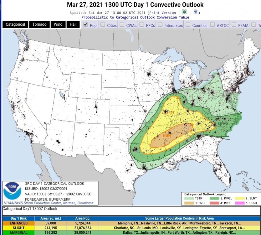
Severe Weather Threat 3/27/21 - NETX/LA/AR
cstrunk replied to cstrunk's topic in Central/Western States
Very strong rotation on the tornado warned cell near Rusk, TX. -
Severe Weather Threat 3/27/21 - NETX/LA/AR
cstrunk replied to cstrunk's topic in Central/Western States
Yes, it is unusable, IMO. Did they not test it out before making the switch?? Takes forever to load and is very glitchy. -
Severe Weather Threat 3/27/21 - NETX/LA/AR
cstrunk replied to cstrunk's topic in Central/Western States
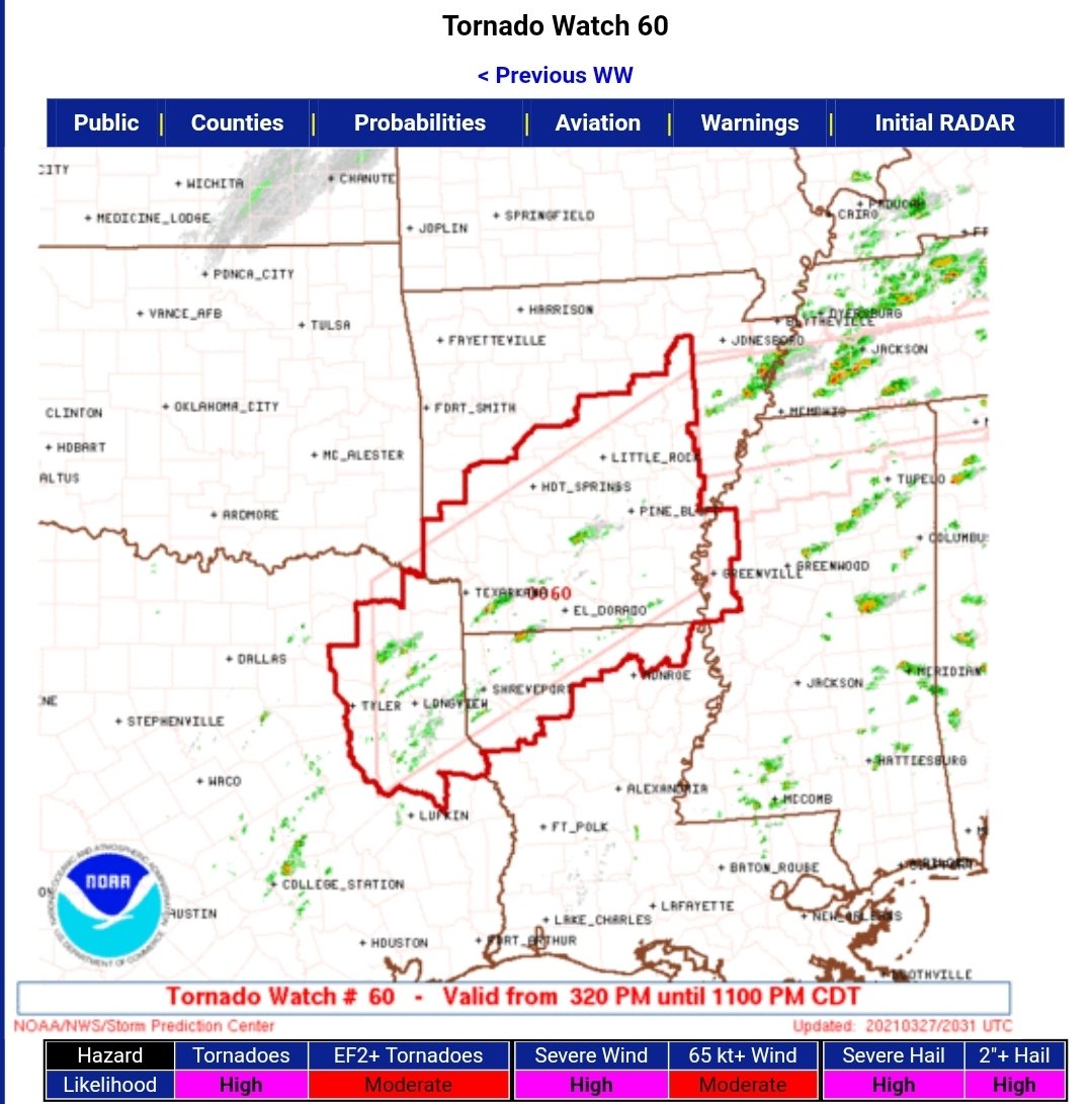
Tornado watch issued. 70/60 probs...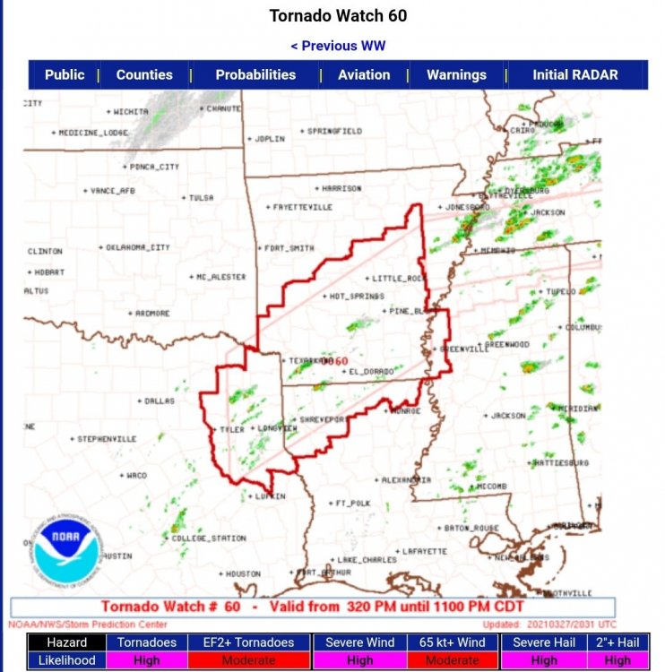
-
This originally looked like a threat farther east of this region, but it has shifted further into our area. Latest short term models show supercells developing in NETX and points northeast by around 2-4 pm. All hazards are included in the threat with some being significant.
-
Actually I think it occluded and a new small tornado formed over Fayetteville.
-
Yeah after a couple increases it looks weaker now...
-
Velocities increasing last scan.
-
Bibb Correctional Facility and likely a bunch of mobile homes on the SW side of Brent. It's on top of the airport now.
-
There are a lot of trailer homes where the tornado is currently.
-
Bibb Correctional Facility just south of Brent, AL looks like it will take a direct hit.
-
Rotation increasing near Watauga or just north of North Richland Hills... No warning yet.
-
Decent hook just north of downtown Fort Worth but not much on velocity yet - keep an eye out.
-
Rotation still pretty broad. Still has a nasty hail core.