cstrunk
-
Posts
608 -
Joined
-
Last visited
Content Type
Profiles
Blogs
Forums
American Weather
Media Demo
Store
Gallery
Everything posted by cstrunk
-
 4.66" at my house in Longview so far. Moderate rain continuing. Looks like 6"+ is going to be likely before the event is over. DFW got hit hard overnight with more on the way, too.
 -
It was modeled /forecast as 8"+ for a pretty big area of N/NE TX as of yesterday and now it's 4-6"+. I would bet it ends up being more like 2-4"+ for most of the area based on model trends and what we've seen so far. A few isolated 6"+ totals. Still very welcome moisture but it's not going to be the drought-buster it was pegged as... For most.
-
Texas/Oklahoma Discussion & Obs Thread 2022
cstrunk replied to It's Always Sunny's topic in Central/Western States
The clouds kept it from getting to 100F here yesterday. The high was only 97F. The rain missed us, but the huge complex in SW AR pushed out some outflow last night that felt pretty good. Another chance of rain today so I've got my fingers crossed. -
Texas/Oklahoma Discussion & Obs Thread 2022
cstrunk replied to It's Always Sunny's topic in Central/Western States
105F yesterday in Longview and we missed the evening storms by 10-15 miles. BUT storms have redeveloped early this morning and we're now getting some pretty good rainfall out of it! Already at 0.88" and counting. Other areas are easily picking up 1"-2"+. *Ended up with 1.19"! -
Texas/Oklahoma Discussion & Obs Thread 2022
cstrunk replied to It's Always Sunny's topic in Central/Western States
Isn't there an update coming to the GFS? Maybe that'll help fix some of those warm bias issues. Otherwise at least a few folks are getting isolated storms/showers today and there are chances over the next couple of days. -
Texas/Oklahoma Discussion & Obs Thread 2022
cstrunk replied to It's Always Sunny's topic in Central/Western States
My weather station hit 104F on Saturday before a brief shower dropped a much-needed 0.18". The temperature quickly rose back to 103F AFTER that. Talk about a sauna! The Longview airport hit 107F - they missed out on any rain. -
Texas/Oklahoma Discussion & Obs Thread 2022
cstrunk replied to It's Always Sunny's topic in Central/Western States
Exactly. In 2011, Tyler, TX had: 81 total days of 100F+ temperatures. 46 straight days of 100F+ temperatures. 28 days of 105F+ temperatures. And only received about 60% of normal precipitation for a 22-month rainfall deficit that reached -33.61". We're not looking at anything quite that bad yet. -
Central/Southern Plains Severe Weather Palooza (4/29 - 05/05)
cstrunk replied to Powerball's topic in Central/Western States
https://www.spc.noaa.gov/products/watch/ww0181.html Tornado Watch with 40/20 probs until 6 pm for a good chunk of central/eastern Texas. -
70/40 probs on the new tornado watch for the Arklatex region.
-
The SPC is considering a tornado watch for the Ark-la-tex region this morning. The HRRR is showing a line of storms/possible supercells in ETX by the 18-20z timeframe.
-
No damage at my house. Gusted 50-60 mph for a couple minutes.
-
Absolutely. Also very interesting how many of the same general areas in Texas were affected tonight as they were a few weeks ago. At least for central and east/NE Texas.
-
The parameters in and near Iowa along and south of the warm front are pretty crazy. One SCP spot showing up of 36. STP up to 6-8. Helicity 400-600.
-
A good day for margarita's in N TX this afternoon with those lime-sized hail pieces falling... I'll be watching for potential pre-MCS supercells in east Texas later this evening. Obviously there will probably be some QLCS tornado potential too with the main line, along with potential 60-70+ mph straight line winds.
-
I'm in Longview. It'll probably be closer to midnight before the current group of storms gets here. Unless something goes severe ahead of it.
-
Well, losing a engine would certainly be a good reason to not fly into a Cat 4 'cane. But what are we doing? Flying WW2 planes into hurricanes? It's 2021 for crying out loud. This program needs more funding.
-
Texas/New Mexico/Louisiana/Mexico Obs And Discussion Thread Part 8
cstrunk replied to wxmx's topic in Central/Western States
This has been a great summer so far. Most days in the 80's or low-90's and above normal precipitation. I haven't had to water my lawn once this year. -
Texas/New Mexico/Louisiana/Mexico Obs And Discussion Thread Part 8
cstrunk replied to wxmx's topic in Central/Western States
I had 0.39" on Monday and 0.3" the previous Monday. I'll take that for late June but hope that continues through the next couple of months. It still looks good for the next few weeks at least. -
Quite a bit of sunshine today, a humid airmass, and relatively strong low level winds make today seem like a stronger risk for severe weather this afternoon in East Texas than many other days that have been cloudy/less windy.
-
7.78" of rain measured at my house in a 22 hour period from 9:30 pm Monday night through 7:30 pm Tuesday night.
-
These training storms are making it awfully hard for me to get back home... (Flight to DFW and then GGG, the latter of which has already been cancelled).
-
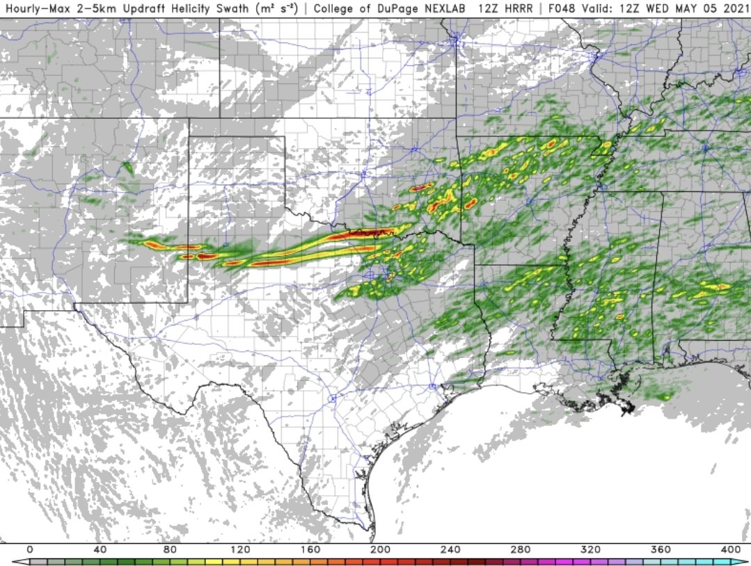
Holy 12z HRRR helicity swaths for NW/northern TX this afternoon...

-
That's just Reed doing Reed things. He acts that way for three reasons. 1) He has an insane passion for severe weather. 2) He knows that he can hype ANYTHING to generate more clicks, views, ratings, etc. which generates him money. 3) He has a screw loose in his head. But whatever you say about him, the dude just gets it done more often than not.
-
Beautiful tornado warned supercell with very strong rotation just north of Guthrie, TX.
-
Messy storm mode in ETX killed the threat.