cstrunk
-
Posts
608 -
Joined
-
Last visited
Content Type
Profiles
Blogs
Forums
American Weather
Media Demo
Store
Gallery
Everything posted by cstrunk
-

Texas/New Mexico/Louisiana/Mexico Obs And Discussion Thread Part 8
cstrunk replied to wxmx's topic in Central/Western States
It felt like early May outside today. High of 87. Tomorrow will be very similar, high of 85. I'm hoping we can get some decent storms out of this system coming later this week. -
Texas/New Mexico/Louisiana/Mexico Obs And Discussion Thread Part 8
cstrunk replied to wxmx's topic in Central/Western States
I tried a test-run of a GoPro time-lapse on my way to work this morning, thinking I might catch some good views with the front/storms moving through. I still have some things to figure out. Luckily, the views weren't that interesting, weather-wise. It was mostly light rain the whole way with a few heavy downpours here and there. -
Texas/New Mexico/Louisiana/Mexico Obs And Discussion Thread Part 8
cstrunk replied to wxmx's topic in Central/Western States
Well it looks like this afternoon was mostly a dud. One storm did get going fairly well around Lake Fork, with a severe warning tagged on it. But it never really looked that ominous except for maybe some hail. I was close to heading out the door to catch up with it before sunset, but decided not to. In hindsight I probably should have, I've been wanting to get more experience in shooting with my old GoPro that I haven't used much. The lack of low clouds in the area might have made for a nice show. -
Texas/New Mexico/Louisiana/Mexico Obs And Discussion Thread Part 8
cstrunk replied to wxmx's topic in Central/Western States
Looks like new storms are firing southeast of Dallas. -
Texas/New Mexico/Louisiana/Mexico Obs And Discussion Thread Part 8
cstrunk replied to wxmx's topic in Central/Western States
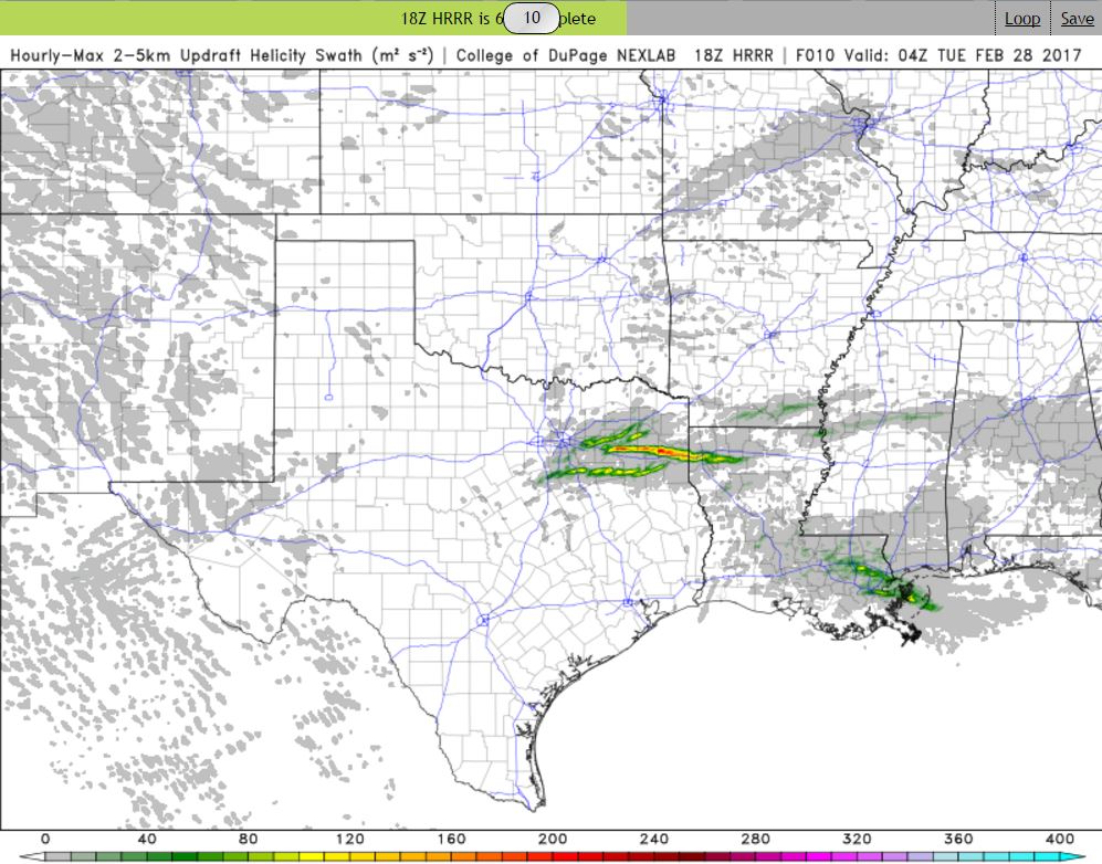
Keeping an eye out this afternoon. The 18z HRRR is hinting at a pretty substantial UD Helicity Swath sweeping through east Texas this afternoon/evening. Pretty much right along I-20 east of Dallas. I wonder if it is picking up on an outflow boundary being laid down by current storms in NE Texas, with later storms firing east/south of Dallas and latching on and riding it all the way to Shreveport? I stepped outside around noon and the atmosphere definitely had that feel to it. The sun is shining and it is 78/64 in Tyler.
-
Texas/New Mexico/Louisiana/Mexico Obs And Discussion Thread Part 8
cstrunk replied to wxmx's topic in Central/Western States
I was hoping for some lightning and thunder overnight... but alas, nothing. Just a steady cool rain. If we aren't going to have any more winter, I'd at least like to get the severe weather season rolling around here. -
Texas/New Mexico/Louisiana/Mexico Obs And Discussion Thread Part 8
cstrunk replied to wxmx's topic in Central/Western States
Looks like a really nice week upcoming for East Texas. Boring as far as precipitation goes, but we'll be close to a record high in Tyler on Monday, February 6th. Forecast high is 83F and the record (1911) is 84F. *EDIT - Looks like the record high is for tomorrow, Tuesday, Feb 7th at 82F. The forecast high is 83F. -
Texas/New Mexico/Louisiana/Mexico Obs And Discussion Thread Part 8
cstrunk replied to wxmx's topic in Central/Western States
We ended up with 5.33" rainfall since this past weekend at my office. -
Texas/New Mexico/Louisiana/Mexico Obs And Discussion Thread Part 8
cstrunk replied to wxmx's topic in Central/Western States
At my office east of Longview, TX, we've had about 3.7" of rain measured in our rain gauge. The streams/creeks are just out of their banks. We may end up with a few more tenths to a half an inch today depending on if we get hit by any of the heavier cells that have yet to move through the area. -
Texas/New Mexico/Louisiana/Mexico Obs And Discussion Thread Part 8
cstrunk replied to wxmx's topic in Central/Western States
Finally seeing a couple flurries here and there in Tyler. Not going to get anything more than this it looks like. Congrats to you guys in DFW with the dusting. -
Texas/New Mexico/Louisiana/Mexico Obs And Discussion Thread Part 8
cstrunk replied to wxmx's topic in Central/Western States
You're still sitting better than us in East TX! Wintry precip to our SE and NW... Nada here. -
Texas/New Mexico/Louisiana/Mexico Obs And Discussion Thread Part 8
cstrunk replied to wxmx's topic in Central/Western States
The radar returns are lining up pretty well with Lake Ray Roberts, Lewisville Lake, and Grapevine Lake. Lake effect snow in DFW... who'da thunk it? -
Texas/New Mexico/Louisiana/Mexico Obs And Discussion Thread Part 8
cstrunk replied to wxmx's topic in Central/Western States
SPC mentions that the front is trending slightly faster, so the severe risk is trending the wrong direction, towards the east. Bummer. Hope that changes. -
Texas/New Mexico/Louisiana/Mexico Obs And Discussion Thread Part 8
cstrunk replied to wxmx's topic in Central/Western States
I hope I did this right and it's not time-sensitive, but I'm glad to see a Day 5 slight risk for deep east Texas. I'd like to see the system slow down a bit and move a bit farther west, but at least there's some interesting non-winter weather possible in my neck of the woods for Saturday: A cherry on the top would be a bit of wintry precip behind the front Sunday morning. At least we have something interesting to follow! -
Texas/New Mexico/Louisiana/Mexico Obs And Discussion Thread Part 8
cstrunk replied to wxmx's topic in Central/Western States
I would love to see some wintry precipitation around Christmas, as long as it doesn't mess with my drive to Iowa from DFW on the 26th! -
Texas/New Mexico/Louisiana/Mexico Obs And Discussion Thread Part 8
cstrunk replied to wxmx's topic in Central/Western States
I wouldn't start worrying until January rolls around and we haven't seen any positive signs. Wayyy too early. -
Texas/New Mexico/Louisiana/Mexico Obs And Discussion Thread Part 8
cstrunk replied to wxmx's topic in Central/Western States
I'm not a good forecaster, but does anyone see any hope at all for any kind of severe weather in the central/east Texas areas? The fall severe weather season has been a dud around here. -
Texas/New Mexico/Louisiana/Mexico Obs And Discussion Thread Part 8
cstrunk replied to wxmx's topic in Central/Western States
The rain has made it to far ETX, or at least parts of it. Getting a pretty good downpour here at work, but just a sprinkle back at my house. No lightning/thunder to speak of. *EDIT* Well, mother nature just made a liar out of me. First crack of thunder. -
Texas/New Mexico/Louisiana/Mexico Obs And Discussion Thread Part 8
cstrunk replied to wxmx's topic in Central/Western States
Heat islands. You can also pick out a handful of other cities; Shreveport, Omaha, New York, etc. And then there's the meat locker known as Amarillo. -
Texas/New Mexico/Louisiana/Mexico Obs And Discussion Thread Part 8
cstrunk replied to wxmx's topic in Central/Western States
We'll take it here in East Texas! My employer had only recorded 0.17" in September and 0.02" in October before yesterday/today. -
Texas/New Mexico/Louisiana/Mexico Obs And Discussion Thread Part 8
cstrunk replied to wxmx's topic in Central/Western States
Lows in the 50's and highs in the 80's recently in ETX. Not too shabby. Getting a few sprinkles today with an afternoon temp of 71 near Longview. We're starting to get dry again so hopefully we get something out of the current 30% chances for Thursday/Friday. -
Texas/New Mexico/Louisiana/Mexico Obs And Discussion Thread Part 8
cstrunk replied to wxmx's topic in Central/Western States
I didn't have high hopes for rain since they lowered the rain chances to 30% in Tyler, but we got lucky and picked up somewhere between 1-1.5" or so. I'm looking forward to the 80's this week. -
Texas/New Mexico/Louisiana/Mexico Obs And Discussion Thread Part 8
cstrunk replied to wxmx's topic in Central/Western States
Yes, it was a weather delay. There were thunderstorms in the area that later dissipated. -
Texas/New Mexico/Louisiana/Mexico Obs And Discussion Thread Part 8
cstrunk replied to wxmx's topic in Central/Western States
We've had maybe a couple of tenths at my apartment in Tyler, TX so far this weekend, once again missing out on any of the heavier downpours. Other areas have been more fortunate and we should get a good rain continuing throughout today. Where I work, we have received about 1"-1.5" this weekend near Hallsville, TX. It is humid outside but it is very nice to have a week of temperatures in the 80's in mid-August in Texas. Glad a lot of places are getting rain as well, luckily nothing like what Louisiana experienced. -
Texas/New Mexico/Louisiana/Mexico Obs And Discussion Thread Part 8
cstrunk replied to wxmx's topic in Central/Western States
The last few days have been interesting, with many areas getting good amounts of decent rainfall from afternoon/evening storms. Yesterday was nice here at work where we had a couple different rounds of thunderstorms and moderate/heavy rain. Afternoon temperatures fell into the low/mid-70's, which is a Godsend in July for this area. Tyler (at least IMBY) has missed most of the more widespread heavy rain, but has had a few localized downpours here and there. We have a couple more days of rain chances before it heats back up and dries out next week.