cstrunk
-
Posts
608 -
Joined
-
Last visited
Content Type
Profiles
Blogs
Forums
American Weather
Media Demo
Store
Gallery
Everything posted by cstrunk
-
Wow.

-
In my unprofessional opinion, it's lower at this time. But there are some small cells in the DFW area and just south that are trying to form. Just not doing much yet. That may change so don't take my word for it.
-
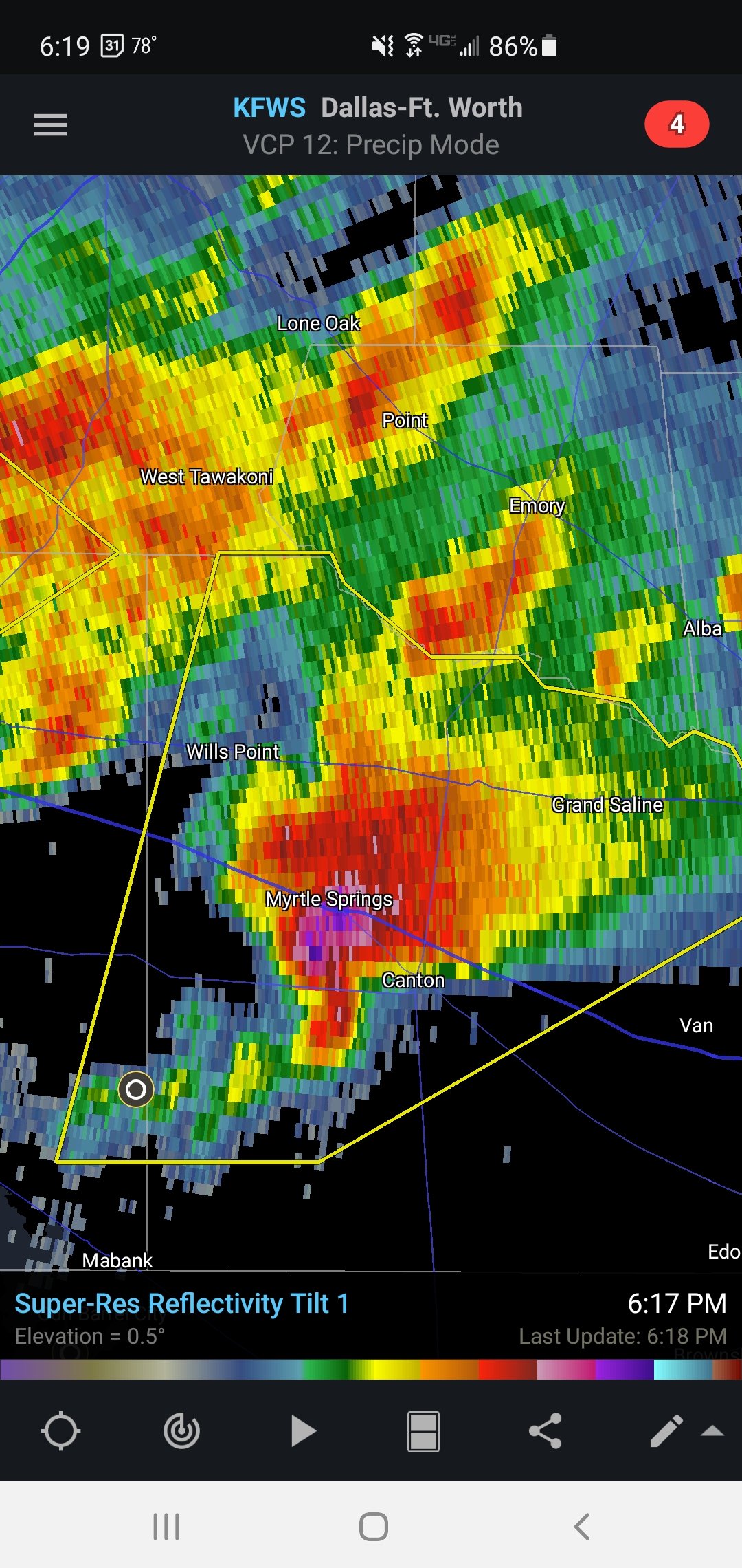
Storms SE of Dallas are all taking on supercellular characteristics on radar. The Mabank storm has a really nice reflectivity presentation already... the others storms have "the look" as well. Large hail threat for sure on the east side of Dallas towards Lindale. Good shear in place but helicity values pretty modest, so the tornado threat will hopefully stay low, but may increase in time...
-
Storms are continuing the organize SE of Dallas. This is where the HRRR was spitting out some helicity tracks for the 5-7 pm range.
-
I thought the watch would have been issued sooner, but they were probably debating whether it should be a SVR or TOR. It seems to me like the 30/10 TOR is appropriate, based on the short-term guidance.
-
Yeah, returns beginning to strengthen, especially SE towards Corsicana and Athens. Looks like it's along the warm front.
-
Reflectivity image is pretty crazy.
-
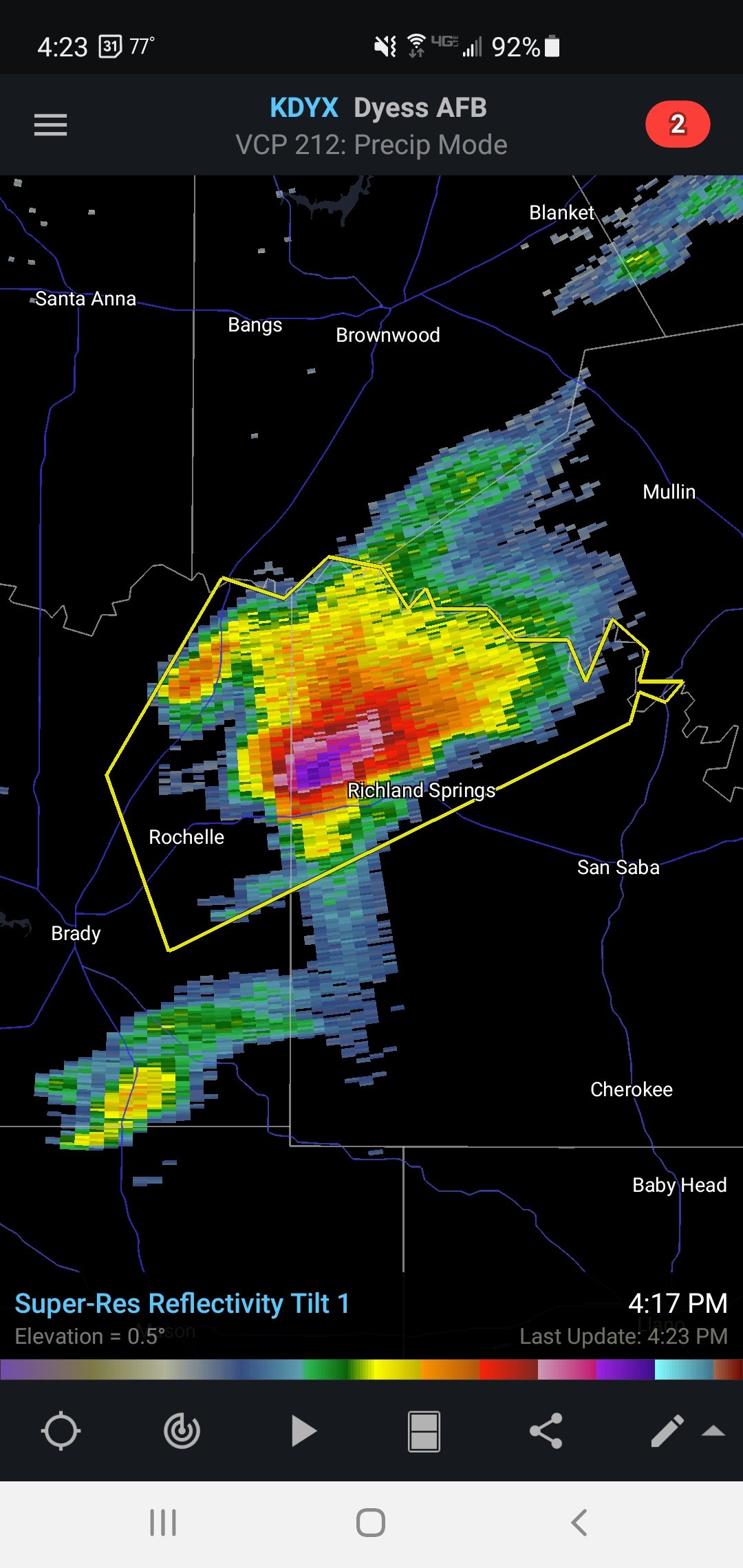
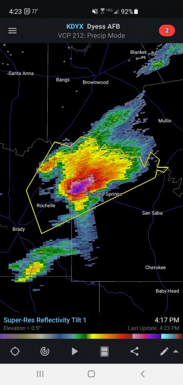
Looks like convection has initiated. Already a SVR for NE McCulloch and NW San Saba counties in central TX. Should see a watch issued soon.
-
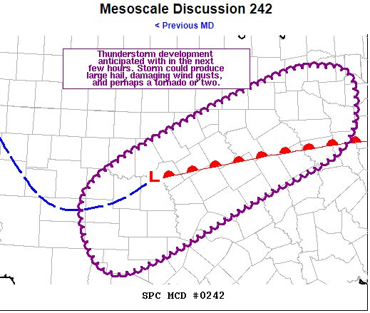
Mesoscale Discussion 0242 NWS Storm Prediction Center Norman OK 0322 PM CDT Wed Mar 24 2021 Areas affected...Central/North-Central TX Concerning...Severe potential...Watch likely Valid 242022Z - 242245Z Probability of Watch Issuance...80 percent SUMMARY...Thunderstorm development is anticipated this evening across western portions of central and north-central TX. Threat for large hail, damaging wind gusts, and perhaps a tornado or two will accompany this storms as they move northeastward into more of central and north-central TX. Trends are being monitored for possible watch issuance. DISCUSSION...Recent surface analysis places a weak low just southeast of BWD in central TX. A warm front extends eastward from this low, demarcated well by both the 56 deg F isodrosotherm and the edge of the cloud shield in visible satellite imagery. A surface trough also extends southwestward from this low before arcing back northwestward south of SJT into the TX Permian Basin. The air mass south of the warm front also continues to destabilize, particularly over the TX Hill County in the vicinity of the low. Recent mesoanalysis suggests MLCAPE around 500 J/kg near the low, increasing to over 1000 J/kg over in the region between Del Rio and San Antonio. Continued destabilization is expected as the warm front continue to move northward. At the same time, persistent low-level convergence in the vicinity of the low and its associated surface trough is expected to result in eventual convective initiation. Visible satellite imagery has shown several attempts at deep convection, although none have succeeded thus far. Current attempt is underway over McCulloch County. In addition to this mesoscale forcing, large-scale forcing for ascent is gradually increasing across the region as a shortwave trough approaches from the west. Once convective initiation is realized, the environment is favorable for maturation into supercells. Primary hazard throughout the evening will be large hail while some damaging downburst winds are also possible. Gradually strengthening low-level could also result in a tornado or two. ..Mosier/Hart.. 03/24/2021 ...Please see www.spc.noaa.gov for graphic product... ATTN...WFO...SHV...FWD...EWX...SJT...
-
Yesterday was a debatable, but today looks like a glorified bust.
-
That looks much more like a shelf cloud with straight line winds moving overhead.
-
Seen this act before. This afternoon was definitely very active, but the large amount of rain in the risk area combined with a large maturing MCS moving through is going to mitigate the risk this evening and overnight. NOT that there won't be a few more tornadoes, and possibly significant at that, but the risk level has definitely decreased.
-
Well, it's likely there are burst pipes that are still frozen and the leak won't be known until the ice thaws. There's still brutal cold in the area and there will continue to be more frozen pipes through the next few days.
-
On the DFW radar, new precip seems to be developing SW of Tyler. You may get in on some of that action. Doesn't seem too heavy yet, but may become so as it heads NE. Looks to keep me in some precip for a while this afternoon, yet. Probably sleet.
-
Heavy sleet and freezing rain now coming down in Longview. The back side of the precip is not moving much at all. Temperature is 24F. Not good...
-
Not much new snow, less than an inch. The rest has been sleet in Longview.
-
Snowing in Longview. Models show precip lasting until about mid-afternoon... Hopefully it stays mostly snow...
-
Here comes my round 2. Beginning as sleet in Longview. 2-3" of snow/sleet followed by 0.1"-0.2" freezing rain seems likely. Hopefully more snow and less ice. I took a drive around town tonight. As expected, the roads are horrible. Still pretty manageable with 4wd, but roadways and especially intersections are becoming very icy as vehicles have continued driving on them.
-
-4F on 1/18/1930.
-
Longview and Tyler broke all-time record lows this morning. -5F and -6F, respectively.
-
-
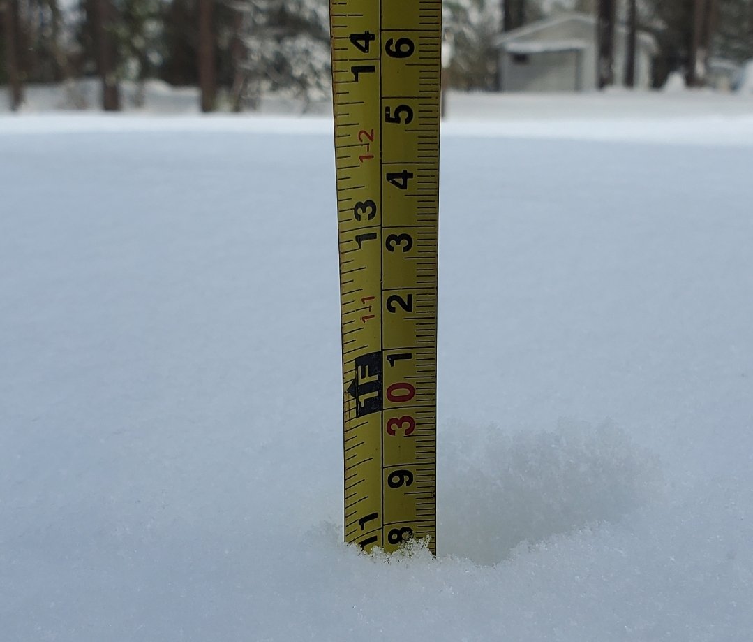
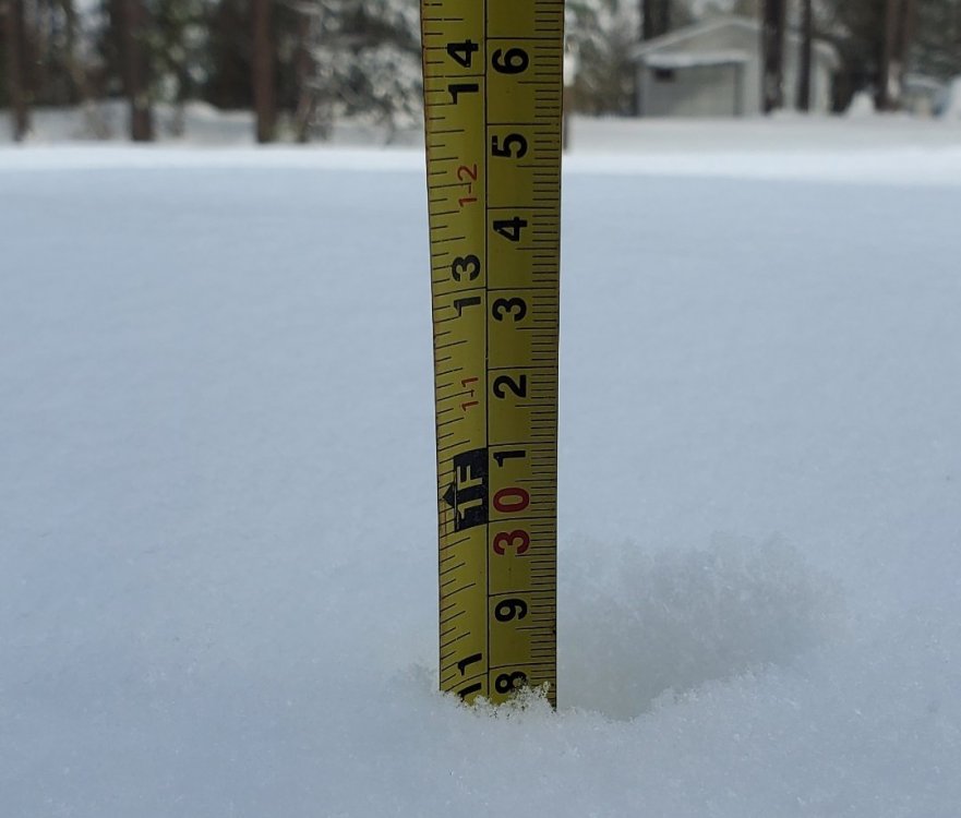
11" on my sidewalk on Longview... amazing.
-
25F and just switched to very light snow with tiny snowflakes in Longview.
-
I'll have to step outside to see what it's like now, but I had to help a friend out tonight and there was ice forming on my bed cover. When I got in my truck to the second time is when I noticed more ice on the door handle and mirror. Roads/sidewalks were fine but that's been about 4 hours ago.
-
Temperatures look to bust way low in Longview. Was originally forecast this morning to get to 40F, they've changed it to 38F. We've actually dropped from 34F to 33F as of 2 pm...