
IntenseBlizzard2014
-
Posts
3,189 -
Joined
-
Last visited
About IntenseBlizzard2014

- Birthday 08/24/1991
Recent Profile Visitors


-
Depends on the plume type. If it's water vapor, we might have additional warming. If it's SO2, then cooling. However, the plume type might not mean much if the eruption is weak. Also, the effects aren't definitive either.
-

January 28-30th Possible Nor'easter
IntenseBlizzard2014 replied to Rjay's topic in New York City Metro
One thing that caught my attention was that the 06Z NAM had a closed-off H5 Low at Delaware's Latitude. That's probably why the snowfall pushed further inland this time. -
January 28-30th Possible Nor'easter
IntenseBlizzard2014 replied to Rjay's topic in New York City Metro
I've been tracking East Coast Winter Storms for quite a while, and what I've seen from the UKMET was quite an eye-opener. -
January 28-30th Possible Nor'easter
IntenseBlizzard2014 replied to Rjay's topic in New York City Metro
The 00Z GEFS looks like puke. Although, based on the latest shifts, I wouldn't be surprised if the GFS OP/GEFS made large adjustments by 06Z. -
Active mid December with multiple event potential
IntenseBlizzard2014 replied to Typhoon Tip's topic in New England
The 06Z GFS really wanted to rush the storm. The H5 vort closed off over NJ while remaining Positive tilted. This would benefit the coast quite a bit, but alas the amount of snowfall would be cut down further inland (Southern NY and NE PA) vs 00Z. Seems like EPA will get the goods on this run. -
It's actually 3.5 days away.
-
2019 ENSO
IntenseBlizzard2014 replied to AfewUniversesBelowNormal's topic in Weather Forecasting and Discussion
The QBO value is nearing the -5 to +5 range. The QBO value as of November 2019 is +5.07. Let's see if the QBO can go a little lower for December. -
IntenseBlizzard2014 changed their profile photo
-
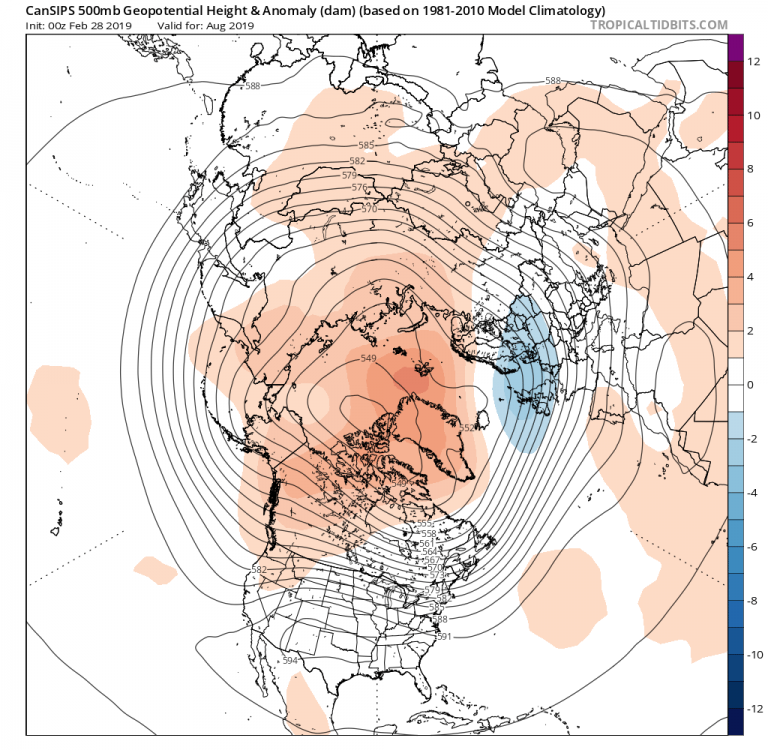
2019 ENSO
IntenseBlizzard2014 replied to AfewUniversesBelowNormal's topic in Weather Forecasting and Discussion
Interesting comparison. The most recent CANSIPS is sniffing this out. July 2019 August 2019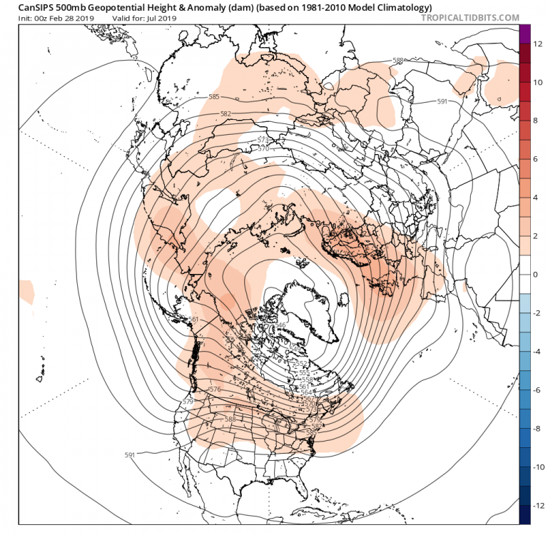
-
2019 ENSO
IntenseBlizzard2014 replied to AfewUniversesBelowNormal's topic in Weather Forecasting and Discussion
You win. -
2019 ENSO
IntenseBlizzard2014 replied to AfewUniversesBelowNormal's topic in Weather Forecasting and Discussion
That -PNA may not last for long when the convection pushes past the Dateline. -
December 25th, 2018. Seems unusual, yet very possible. The MJO will go for a stronger burst through Phase 7/8/1 through December 20th. Which will make it very favorable for colder and stormier weather a few days later.
-
Vendor, Blog and TV Channel Forecasts Thread Part 2
IntenseBlizzard2014 replied to Rjay's topic in New York City Metro
This is understandable. If we get a typical Central Based/-QBO/-PDO. Then this forecast can verify quite easily. -
Central/Western Medium-Long Range Discussion
IntenseBlizzard2014 replied to andyhb's topic in Central/Western States
Yes please. This will be very welcomed. -
Central/Western Medium-Long Range Discussion
IntenseBlizzard2014 replied to andyhb's topic in Central/Western States
Thanks to the stubborn Upper Level Ridge NW of Hawaii, there won't be any canes nearing Central/Southern Cali. It looks like Odile is going to be the closest to the heart of the drought areas without actually putting any meaningful dent into the drought. -
EWR: 10 NYC : 8 LGA : 8 JFK : 7 Based on the latest JMA, it is showing below average temperature departures for 60% of the Eastern US for JJA. El Ninos produce wetter conditions (ie September 1982) for a large chuck of the US. Mainly at Southern California through Texas and into the Southeast. At times, there are troughs that swing through the NE and we get strong LPs producing wetter conditions for the Northeast and Northern Mid Atlantic. So those of you on this topic, beware because if you are planning to go to the beach it won't be good. This Summer could challenge 2009 in terms of temperatures, but the rainfall won't be overbearing like 2009. A weaker Nino this time around will have lesser effects, so a summer like 2009 will be close, but there may be a few more 90s This Summer Vs. 2009. The central theme for this summer is Cool and Dry/Wet and Hot/Dry with Afternoon Thunderstorms (Possibly Severe).


