

Carvers Gap
-
Posts
17,458 -
Joined
-
Last visited
Content Type
Profiles
Blogs
Forums
American Weather
Media Demo
Store
Gallery
Everything posted by Carvers Gap
-

December 2020 Medium/Long Term Pattern Discussion.
Carvers Gap replied to John1122's topic in Tennessee Valley
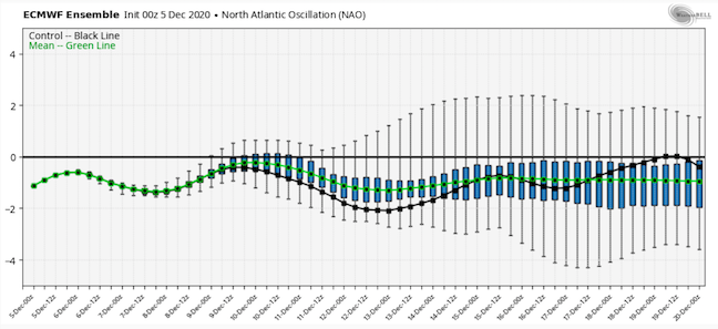
The 12z EPS AO is at -2 in places. So, looks like if we are going to have winter...the Atlantic is the ticket(think Jeff said as much in the winter thread). The MJO continues to look putrid which is a surprise to me. Would not be surprised to see it rotate over to 7, 8, 1 in a couple of weeks as some of the OLR maps show a diminishing wave over the warmer phase areas in the wester PAC and Indonesia. -
December 2020 Medium/Long Term Pattern Discussion.
Carvers Gap replied to John1122's topic in Tennessee Valley
The EPS ensembles are running about -1 for the NAO which is much more negative than the Weeklies from TR. Will try to post some LR pics. The EPS, if right, would provide us with some chances. I don't think anyone has been promising a big winter, but that look is not as bad as I thought it would be. -
December 2020 Medium/Long Term Pattern Discussion.
Carvers Gap replied to John1122's topic in Tennessee Valley
Beast of a -NAO showing up on the 12z EPS. No idea if that verifies, but seems to be a feature that has some staying power(and not just in the LR). What do you think? -
December 2020 Medium/Long Term Pattern Discussion.
Carvers Gap replied to John1122's topic in Tennessee Valley
Sneaky system for NE TN and SW VA tomorrow. Looks like light rain in the valley, but if this comes in over night with a period of clearing right before onset.... -
December 2020 Medium/Long Term Pattern Discussion.
Carvers Gap replied to John1122's topic in Tennessee Valley
To echo what John said above, the 0z EPS d10+ was a significant improvement, and an example of how we stay in a colder pattern with the AK vortex. The tricky party of that is a -NAO/-AO couplet, and it has been some time since we have seen that feature stay for long periods of time during winter. Might this be that winter? I don't know. That said, the 0z EPS has a decently consistent negative AO/NAO couplet. This creates a feature which has been unusual during the past decade. That feature is BN heights in both AK and the Southeast US. That can happen, but help from the Atlantic is usually how that occurs. One final comment...as I went to pull these up, it appears the big change is the AO over the past few runs of the EPS is actually more negative.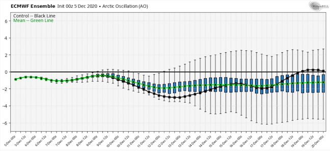
-
December 2020 Medium/Long Term Pattern Discussion.
Carvers Gap replied to John1122's topic in Tennessee Valley
After next week, looks like the current cooler pattern will relax or change to a new pattern from say Dec 18-Jan7. The CFSv2 implies that the trough will return early in the new year as does the GEFS extended. The GEFS holds a -AO/-NAO couplet. The GEPS/EPS lose the Pacific. The American model suites tend to have an Atlantic driven pattern - that would be unusual per the last decade's results and should be viewed with some healthy skepticism - but not discounted. The warm pool in the northern Pacific is making it tough for troughs to hold there IMO. In the days (prior to winter disappearing after early Dec), we would call what is upcoming a "thaw," and would be a very normal time frame for that to happen. So, looks like the second week in January is the fork in the road. If we are going to have winter return, looks like that is the time - and by "return" I just mean a healthy pattern where things oscillate between warm and cold (I don't think we lock into a cold pattern this winter for more than 10 days or so). -
December 2020 Medium/Long Term Pattern Discussion.
Carvers Gap replied to John1122's topic in Tennessee Valley
Interesting for sure and a great share. Looks like the 6z off-run of the Euro is slightly SE of 0z. Wonder if the models which over-amped the last storm are doing the same with this one? I bet the solution is somewhere in between the Euro/UKMET and GFS. Probably not good for us as that would shift the phase eastward, but probably less benign than the GFS. -
December 2020 Medium/Long Term Pattern Discussion.
Carvers Gap replied to John1122's topic in Tennessee Valley
Good find. Nice snow at the surface in SW VA which is a BIG change. Was fairly benign until that run. -
December 2020 Medium/Long Term Pattern Discussion.
Carvers Gap replied to John1122's topic in Tennessee Valley
For those new to the forum, this is what a lot of us look at(maybe not this company, but overlays or side-by-sides) of previous runs in order to see trends. This is the 12z(left) and 0z(right) of the GEPS(Canadian ensemble). You can see the trough digging much deeper with the EPO really stout. Now, it likely still lifts out...but that is a pretty significant change. This is at range and changes are to be expected. IF it were to verify, that is a very cold look. The difference at 500 is Ohio to central FL in comparison between runs at 500. -
December 2020 Medium/Long Term Pattern Discussion.
Carvers Gap replied to John1122's topic in Tennessee Valley
12z GEPS(Canadian) starting the d10+ time frame with a much deeper trough in the East. Ridge out west is proving to be a stubborn feature. Will update in this post for the rest of its run if I get a chance. ...Not going to post much more as the run at 258 is much colder(just looking at 500) with another shot of cold air coming from upstream. It may well eventually revert to its 0z look, but that is a rally cold look. -
December 2020 Medium/Long Term Pattern Discussion.
Carvers Gap replied to John1122's topic in Tennessee Valley
12z GEFS really holding that ridge in the West(though suppressed after d10) along with BN heights in Alaska. Very warm temps in the western states as a chinook is cranking. Looks like a combo of Pacific and Canadian air for here as some of that Alaskan cold makes its way SE towards the EC. Persistent AN temps in the West to even much AN. The MJO still is a fairly weak signal. Some modeling does have clusters that try to rotate it back into the COD or cold phases after a quick trip at low amplitude into the warm phases(measured in just a few days). The SE still remains fairly chilly to seasonal. Going to need more cold air for a winter storm pattern, but not as warm as 6z. I would say this is a timeframe(d12+) of high uncertainty. -
December 2020 Medium/Long Term Pattern Discussion.
Carvers Gap replied to John1122's topic in Tennessee Valley
Just digging through the global ensembles this morning, I think I like the time frame between Dec10-17th in terms of more chances for snow. I wouldn't rule out some snow showers early next week in NE TN, but a good rule of thumb for northern stream energy at range...often trends well north of original modeling. Very well could see some cutters driver the cold boundary south and east of the area between now and the 10th. -
December 2020 Medium/Long Term Pattern Discussion.
Carvers Gap replied to John1122's topic in Tennessee Valley
I do think we will see one more eastern trough amplification prior to BN heights pulling into the Yukon after mid-month. Also, the NAO/AO couplet is a huge wild card along with the PV getting disrupted. I suspect that the weak MJO is going to allow for more mischief than last winter, but again, that is not an earth shattering prediction given how bad last winter was....I actually though the GEFS extended didn't look all of that bad last night(runs once per day). -
December 2020 Medium/Long Term Pattern Discussion.
Carvers Gap replied to John1122's topic in Tennessee Valley
Looks like LR range trends overnight after say d12 are for the EPO/PNA to be positive. The one silver lining is the AO and NAO couplet are negative. Likely means that will the trough is in the West, there will be cold moving eastward periodically over time. That said, let's see if all of that actually verifies. Many of the LR models completely missed the cold during the first two weeks of December. One thing I have noticed is high pressure really want to park itself right over the NW PAC warm pool. So, there may be issues with a deep trough being able to establish itself in the West. -
December 2020 Medium/Long Term Pattern Discussion.
Carvers Gap replied to John1122's topic in Tennessee Valley
The 12z EPS is not a bad look in terms of cold. Probably will be some cutters involved with that look as well which definitely could produce some rumbles of thunder in NE TN. One interesting thing I noticed is the ridge backing into the Bering Strait. Normally, I am not a huge fan of that, but there are some winters where that was prominent and are notable exceptions to that thought. January of 1996 is one of those analogs. In the Northern Hemisphere, the January 96 analog looks nearly identical to what the EPS is depicting at the very end of its run. Yesterday, I thought aloud about whether this winter would be like 89-90 where winter started early and evaporated or if it would be like 95-96 where it continued - obviously any 95-96 reference is a "lite" version as extremes like that are exactly that - extremes. If I get time later I will share the similarities, but one of those similarities is a ridge off the end of the Aleutians and extending into eastern Russia. Rainshadows 59-60 comparison is a good one as well. No idea where this pattern is heading after Christmas, but just kicking the can around a bit. -
December 2020 Medium/Long Term Pattern Discussion.
Carvers Gap replied to John1122's topic in Tennessee Valley
12z GEFS and GEPS definitely showing a trough which slips back into Alaska after 300. LR guidance has been bouncing around with how far that cold can intrude into the US. Depending on where that boundary sets up (the AK trough potential nosing SE) will tell us a lot about things going forward after mid-month. As for severe, the "thunder in the mountains" saying (snow within 10-14 days) has been pretty sound in recent years.... If the MJO can make it out of the COD, will be interesting to see how long it stays in the warmer phases. Some schools of though out there that it may just keep going which would be fine by me. After the system this weekend, there may be a few shots of cold/snow showers after that...we will see if that trough lifts out with the storm or digs in for a few more days. -
December 2020 Medium/Long Term Pattern Discussion.
Carvers Gap replied to John1122's topic in Tennessee Valley
Just looking at today's MJO forecasts...beware. The MJO has gone weak sauce(even more so than the last mention of it I had) - meaning it can barely get out of the COD. The ensemble clusters are either more COD or very weak 4-5-6. The hi-res models, which at one point propagated into warmer phases, are literally stuck in one place. I think this is likely why we are seeing the look that John noted last night which is a trough stretching from AK to the SE. Normally, one would think the SE would have a ridge blunt that cold intrusion. IF(emphasis on IF) the MJO is correct, it may be muted if today's ECMWF and NCEP modeling is accurate on the CPC site. That might ever so slightly open the door for a colder SE than once thought after Christmas. Just spitballing, it might mean we get a normal cold configuration of La Nina, but the SER might be muted enough that cold could head SE. In recent years, that cold has had trouble getting past the Plains, but that was with a very strong MJO which seemed camped out at high amplitude in the warm phases of 4-6. -
The first day of meteorological winter IMBY. Had a dusting on the ground. Wind chills were in the teens for much of the day. The mountains had near blizzard conditions. Ski slopes have to be loving this. No idea if it lasts, but what a great day for winter lovers across the eastern half of the state. That is how you start winter right there.
-
December 2020 Medium/Long Term Pattern Discussion.
Carvers Gap replied to John1122's topic in Tennessee Valley
Whole lot of energy running around on that map. Looks like a phase just east of the area to quote a good friend. That said, the trough over TN is about to go negative tilt. As we learned with this last storm, phases are finesse deals. Most modeling just "figured out" today that a storm was possible. Have to think no solution is locked in... That said, I would be feeling pretty good in the NE with that look. We really need to be pulling for that energy to go neg tilt slightly earlier. The 18z GFS was well west of the RGEM and is on the others side of the envelope. Kind of like being in the middle of two solutions at this point. LOL. Great share. Illustrates the complexity and coolness of following winter storms. Bunch of 1s and 0s make a pretty neat map and solution. -
Oak Moon Upslope/ Upper Low Storm Obs
Carvers Gap replied to Holston_River_Rambler's topic in Tennessee Valley
I chose the name Carvers Gap for two reasons. It is where my Grandad used to go birding and was less crowded than the Smokies(not so today) and the wx there is pretty much the most extreme place in Tennessee where I can get that is within about 1.5 hours of leaving my driveway. The extremes are impressive. I don't go up there during storms like this...too dangerous for my blood. I leave that to the young folks. When I go, I go the next day or so. There are times when drifts get up to my waist. This summer, the place was packed. Unfortunately it has been discovered by the hoard. I have a few places still in NE TN where I go which are still crazy weather wise, but tough to top that area in terms of wild weather. That is EXTREME northwest flow right there. Looks like some of that is from round bald just up from the parking lot. Impressive footage. Not jealous of that drive back down though! Again, be sure to have the sound on...this is different than the post above BTW.- 300 replies
-
- 5
-

-

-
- upslope snow
- upper level disturbance
- (and 3 more)
-
December 2020 Medium/Long Term Pattern Discussion.
Carvers Gap replied to John1122's topic in Tennessee Valley
D14+...Just looking at the MJO, that is some weak sauce stuff. Maybe it trends stronger like last year, but it can barely get out of the COD. And it looks like modeling wants to get it into cooler phases quickly if it goes into the warmer phases at some point - which looks low amplitude at this point. Might be tough to get this trough out of the East...maybe we get the pattern where the cold extends from western Canada and into the nation's mid-section with bouts of cold in the East. Primary storm track is a cutter into the Ohio Valley with secondary up the coast? Are we going to go with a "Dec 1989 Lite" look with a flip to warmth for the rest of winter or maybe a "95-95 Lite" look? I have no idea. The ensembles in the LR seem sort of split on the matter. Those are cold maps around d10+ off the top of my head. Been a long time since we have seen a full latitude trough...of course we could just go zonal. Until then, we might have some more things to track for the next 2.5 - 3 weeks. -
December 2020 Medium/Long Term Pattern Discussion.
Carvers Gap replied to John1122's topic in Tennessee Valley
I know I sound like a broken record, but there is a load of energy about to come together this weekend on the EC. -
December 2020 Medium/Long Term Pattern Discussion.
Carvers Gap replied to John1122's topic in Tennessee Valley
Also beginning to see the pattern breakdown late in week 3 on both the EPS and GEPS with the trough lifting towards Alaska and the SER waiting in the winds as the EPO retrogrades into the Aleutians. Long way off and that could change, but is a very persistent signal on modeling and Weeklies runs. -
December 2020 Medium/Long Term Pattern Discussion.
Carvers Gap replied to John1122's topic in Tennessee Valley
Euro is a big change towards a halfway consolidated low in the Piedmont. EPS concurs. Nice 12z suite. -
December 2020 Medium/Long Term Pattern Discussion.
Carvers Gap replied to John1122's topic in Tennessee Valley
Regarding the 12z suite....That is now the ICON, GFS, and now GEM with systems coming out of the GOM just after hour 84. Again, cold source is lacking...but that track (SE to NE) can be snow in the NW quadrant at this time of year.