

Carvers Gap
-
Posts
17,451 -
Joined
-
Last visited
Content Type
Profiles
Blogs
Forums
American Weather
Media Demo
Store
Gallery
Everything posted by Carvers Gap
-

December 2020 Medium/Long Term Pattern Discussion.
Carvers Gap replied to John1122's topic in Tennessee Valley
Yeah, modeling seems to be feeling the presence of the NAO for sure. I am not ready to buy that feature quite yet as there has been a wicked bias towards that. However, we are long over due for a -NAO. Seems lately that the disruption of the SPV and -NAO go hand in hand...but seems like the NAO flashes and then disappears. So, we will see what happens. I was honestly surprised the Weeklies didn't look worse at 500. If they had run from 12z, likely would have looked even better. Again, lots of cutters and maybe some storms passing underneath if the block verifies. Seems like when the NAO shows up, it is often a fixture for most of winter...but ready to see it verify for a week or two before really believing staying power. IF(stress) that is a real feature, that should begin to create a feed(with the unfavorable PAC) into the norther Rockies which bleeds eastward at times. Not an exceptional winter pattern, but probably has the potential to be better than the last few winters. AN temps in January(provided they are slightly AN), can do the trick if timing is right. The NAO would provide for more confluence along the EC. Anyway, way out there...but worth a mention. Hey, it is early Dec...most years(prior to the last five winters) I really wouldn't expect winter wx until later this month or Jan. -
December 2020 Medium/Long Term Pattern Discussion.
Carvers Gap replied to John1122's topic in Tennessee Valley
The Weeklies seem to imply that the cold is going to push after initially going West. And that is extremely cold air in Alaska. When operationals start to bounce around usually some very cold air in NA...noticed both of those characteristics at 12z today. -
December 2020 Medium/Long Term Pattern Discussion.
Carvers Gap replied to John1122's topic in Tennessee Valley
I personally didn't think the Euro Weeklies looked terrible for 850temps(I never uses its surface temps...terrible warm bias) and 500 maps. The 12z EPS was quite a bit different. In the past few runs it has eliminated the ridging under neath and was quite close to opening the door for the air mass in AK to drop into the nation's mid-section. Will try to post more later. -
December 2020 Medium/Long Term Pattern Discussion.
Carvers Gap replied to John1122's topic in Tennessee Valley
12z Euro continues with a progressive pattern of cutters and low road lows(which lack cold). What is actually cool about that run is that it has the AK to SE trough(albeit temporary) which ensembles have struggled with for about a week. Some bitterly cold air in north/central Canada along the eastern shores of Hudson Bay. -
That's pretty hilarious. I see that we have a few who speak our local wx microclimate dialect.
-
December 2020 Medium/Long Term Pattern Discussion.
Carvers Gap replied to John1122's topic in Tennessee Valley
Whew. Good luck making heads or tails out of any of those runs - GEM or GFS at 12z. Lots of cutters. Maybe one or two taking the low road with cold air lacking. When models goes haywire like that, makes me wonder if we are about to see some very cold air invaded the lower 48, maybe just after the day14-16 window(basically just outside of modeling's range). Lots of chaos in those two model runs. -
December 2020 Medium/Long Term Pattern Discussion.
Carvers Gap replied to John1122's topic in Tennessee Valley
I have to be honest...I am not seeing a locked-in pattern on the operational runs at all. Just looks like a pattern with a lot of variability. -
Inside joke for the rest of the TRI Kingsport crew. If you know what we are talking about, discuss let's not...we all need our relatives still working. LOL...downsloping is just one of the problems we have to overcome.
-
LOL. You know we are going to be last in Kingsport and you know why!
-
December 2020 Medium/Long Term Pattern Discussion.
Carvers Gap replied to John1122's topic in Tennessee Valley
About 300, the 18z GEFS has a ridge now out West. Likely temporary, but illustrates the uncertainty after the 18th. -
December 2020 Medium/Long Term Pattern Discussion.
Carvers Gap replied to John1122's topic in Tennessee Valley
Also in the "evening" news from the MA forum(above info was from there as well), the 18z GFS does put the hammer on the SPV. Bout all I got for now. -
December 2020 Medium/Long Term Pattern Discussion.
Carvers Gap replied to John1122's topic in Tennessee Valley
DT is mentioning a fairly significant weakening of the La Nina (maybe in the Euro sesaononals) over the next six months. Not sure that helps us at this latitude as it might not help until March. That said, I will take a weakening Nina vs a strengthening one. It is very important to note that most ensembles, monthly model runs, and seasonal models missed the December cold snap. I will post the Euro seasonal for December if I get a chance later. That said, if the Euro is going to miss...Nov/Dec are usually excellent candidates. -
December 2020 Medium/Long Term Pattern Discussion.
Carvers Gap replied to John1122's topic in Tennessee Valley
That is kind of my thinking. Maybe get some truly cold air into the Rockies and let it bleed eastward at times. -
December 2020 Medium/Long Term Pattern Discussion.
Carvers Gap replied to John1122's topic in Tennessee Valley
Hey, man. Glad to see back posting more. -
December 2020 Medium/Long Term Pattern Discussion.
Carvers Gap replied to John1122's topic in Tennessee Valley
Cold shot comes through the 13th. Right now looks dry before the next system may cut right at the end of that timeframe you mentioned. IMHO, still a lot of uncertainty during that time frame. The 12z Euro operational has a really strong trough amplification then. Would not surprise me to see something along the EC. Euro pops a low off NC around the 15th. -
December 2020 Medium/Long Term Pattern Discussion.
Carvers Gap replied to John1122's topic in Tennessee Valley
MRX afternoon disco... https://forecast.weather.gov/product.php?site=MRX&issuedby=MRX&product=AFD&format=CI&version=1&glossary=1 Soundings show rain changing to snow across the highest peaks of our mountains shortly after 06Z tonight. A good burst of snow is expected from 09Z to 12Z as lift is maximized due to strong vorticity moving through with the trough axis. 1 to 2 inches are expected during this time. From 09z to 12Z is also when valley areas have the best chances to see some rain, and perhaps a few snow flakes where cold enough. After the trough passes, around 12Z, the winds shift to the northwest and the mid-levels begin to dry out. When the wind shift occurs is when the northwest flow snow machine takes over across the eastern mountains. The favored upslope areas will see snow from 12Z Monday through early Tuesday morning. The bulk of the accumulating northwest flow snow occurs between 12Z Monday and 21Z Monday afternoon, then tapering off to lighter snow showers through early Tuesday morning. Total event snow, 06Z Monday through 00Z Tuesday is on the order of 1 to 3 inches above 2500 feet and 2 to 4 inches above 4000 feet. Locally higher snowfall amounts are possible across the highest peaks. Elevations below 2500 could see minor accumulations from a dusting up to half an inch near the foothills of the eastern mountains and across portions of southwest VA. The northern Cumberland Plateau may see a dusting. A winter weather advisory will be in place from Midnight tonight through Midnight Monday EST for portions of the east TN Mountains. A few flurries will remain through Tuesday morning. For Valley locations, flurries may linger after day break across the central valley and northward but will taper off through early afternoon. Clouds will be around for most of the day with temps only climbing to around 40 degrees and breezy northwest winds will make it feel even colder with wind chills around freezing. Wind chills across the highest elevations will approach single digits from late Monday afternoon and through the overnight hours. -
December 2020 Medium/Long Term Pattern Discussion.
Carvers Gap replied to John1122's topic in Tennessee Valley
Nah, it is LR forecasting...we all eat our words often! Great thing about our forum is we can throw ideas out there and take chances. Only way to get better is not to be afraid to be wrong, right? Definitely has a zonal look. One thing I have noted is that the LR models have missed strong trough amplifications of late. Anywhere where trends are heading BN may well be much colder as time gets closer. -
December 2020 Medium/Long Term Pattern Discussion.
Carvers Gap replied to John1122's topic in Tennessee Valley
The Atlantic is the wild card in modeling right now. Will it actually verify? Still think the warm water in the NW PAC makes it tough to put a trough into the West without a ridge popping there from time to time. Good trends in the LR compared to two days ago - not great but not terrible. Thing is those -NAO looks seem to be a bias and/or also seem to pop right around the time the SPV gets jostled. Definitely not bailing out on winter on December 6th. Probably going to be long bouts of warm, but have to think we see some shots of cold from time to time. If anything this year has taught me, take it a day at a time and enjoy each moment....well and 2020 has certainly proven that things can change quickly. -
December 2020 Medium/Long Term Pattern Discussion.
Carvers Gap replied to John1122's topic in Tennessee Valley
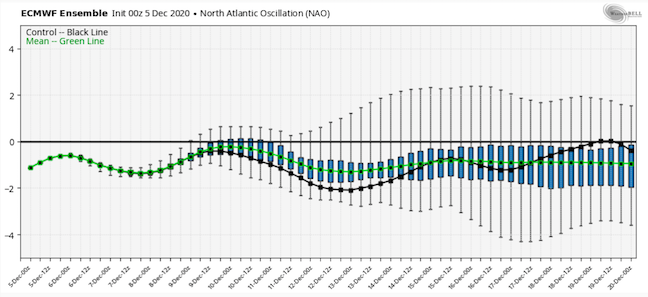
The 12z EPS AO is at -2 in places. So, looks like if we are going to have winter...the Atlantic is the ticket(think Jeff said as much in the winter thread). The MJO continues to look putrid which is a surprise to me. Would not be surprised to see it rotate over to 7, 8, 1 in a couple of weeks as some of the OLR maps show a diminishing wave over the warmer phase areas in the wester PAC and Indonesia. -
December 2020 Medium/Long Term Pattern Discussion.
Carvers Gap replied to John1122's topic in Tennessee Valley
The EPS ensembles are running about -1 for the NAO which is much more negative than the Weeklies from TR. Will try to post some LR pics. The EPS, if right, would provide us with some chances. I don't think anyone has been promising a big winter, but that look is not as bad as I thought it would be. -
December 2020 Medium/Long Term Pattern Discussion.
Carvers Gap replied to John1122's topic in Tennessee Valley
Beast of a -NAO showing up on the 12z EPS. No idea if that verifies, but seems to be a feature that has some staying power(and not just in the LR). What do you think? -
December 2020 Medium/Long Term Pattern Discussion.
Carvers Gap replied to John1122's topic in Tennessee Valley
Sneaky system for NE TN and SW VA tomorrow. Looks like light rain in the valley, but if this comes in over night with a period of clearing right before onset.... -
December 2020 Medium/Long Term Pattern Discussion.
Carvers Gap replied to John1122's topic in Tennessee Valley
To echo what John said above, the 0z EPS d10+ was a significant improvement, and an example of how we stay in a colder pattern with the AK vortex. The tricky party of that is a -NAO/-AO couplet, and it has been some time since we have seen that feature stay for long periods of time during winter. Might this be that winter? I don't know. That said, the 0z EPS has a decently consistent negative AO/NAO couplet. This creates a feature which has been unusual during the past decade. That feature is BN heights in both AK and the Southeast US. That can happen, but help from the Atlantic is usually how that occurs. One final comment...as I went to pull these up, it appears the big change is the AO over the past few runs of the EPS is actually more negative.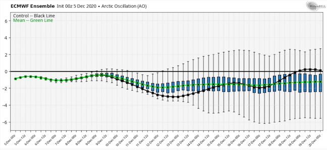
-
December 2020 Medium/Long Term Pattern Discussion.
Carvers Gap replied to John1122's topic in Tennessee Valley
After next week, looks like the current cooler pattern will relax or change to a new pattern from say Dec 18-Jan7. The CFSv2 implies that the trough will return early in the new year as does the GEFS extended. The GEFS holds a -AO/-NAO couplet. The GEPS/EPS lose the Pacific. The American model suites tend to have an Atlantic driven pattern - that would be unusual per the last decade's results and should be viewed with some healthy skepticism - but not discounted. The warm pool in the northern Pacific is making it tough for troughs to hold there IMO. In the days (prior to winter disappearing after early Dec), we would call what is upcoming a "thaw," and would be a very normal time frame for that to happen. So, looks like the second week in January is the fork in the road. If we are going to have winter return, looks like that is the time - and by "return" I just mean a healthy pattern where things oscillate between warm and cold (I don't think we lock into a cold pattern this winter for more than 10 days or so). -
December 2020 Medium/Long Term Pattern Discussion.
Carvers Gap replied to John1122's topic in Tennessee Valley
Interesting for sure and a great share. Looks like the 6z off-run of the Euro is slightly SE of 0z. Wonder if the models which over-amped the last storm are doing the same with this one? I bet the solution is somewhere in between the Euro/UKMET and GFS. Probably not good for us as that would shift the phase eastward, but probably less benign than the GFS.

