

Carvers Gap
-
Posts
17,457 -
Joined
-
Last visited
Content Type
Profiles
Blogs
Forums
American Weather
Media Demo
Store
Gallery
Everything posted by Carvers Gap
-

December 2020 Medium/Long Term Pattern Discussion.
Carvers Gap replied to John1122's topic in Tennessee Valley
That is a massive vort coming out of the Plains at 132...going to have to be reckoned with. -
December 2020 Medium/Long Term Pattern Discussion.
Carvers Gap replied to John1122's topic in Tennessee Valley
Good stuff. Yeah, 18zGFS is west a hair though the slp is a bit strung out between two pieces of energy. I am just now resigned to following the dry slot to see if the system is moving east or west. The precip shield is a hair west in west TN. Definitely worth trying to see the 0z runs. Just let me see some snow in early Dec, and I am ready to roll. LR ensembles still look good through mid December. Am watching to see what happens on the GFS after 120 on this run... -
December 2020 Medium/Long Term Pattern Discussion.
Carvers Gap replied to John1122's topic in Tennessee Valley
There is no shame in hoping for a solution that hammers your local...same goes for everyone else. LOL. If we had that run in January, all of the northwest quadrant would be snow. -
December 2020 Medium/Long Term Pattern Discussion.
Carvers Gap replied to John1122's topic in Tennessee Valley
Definitely jog SE over the past couple of days and with this past run...but can it get east of the mountains? Just seems to me like a track between Asheville and Charlotte makes the most sense with maybe a some energy running up the eastern valley(aka the warm nose). Pretty crazy to see that type of move this late in the game. Think it is a testament to how tough this phase is to model. NAM is definitely northwest of its previous run as you all have noted. The storm right after this also has my attention. Looks like it will be further east with enough separation and maybe storm 1 providing a bit of a block to slow it down so it can phase. Really like the energy coming across the TN Valley feeding into that coastal. Chance for a really big storm for eastern sections IF it were to phase earlier. -
December 2020 Medium/Long Term Pattern Discussion.
Carvers Gap replied to John1122's topic in Tennessee Valley
So is the NAM the furtherest West solution now? Going to be a good upslope event. MRX has updated their afternoon disco and has a prelim snow map. Elevation driven event for their forecast. -
December 2020 Medium/Long Term Pattern Discussion.
Carvers Gap replied to John1122's topic in Tennessee Valley
Second storm on the 12z GFS just a monster with 957mb off Bar Harbor. (saw the mention in the MA thread and thought...no way....well, way) -
December 2020 Medium/Long Term Pattern Discussion.
Carvers Gap replied to John1122's topic in Tennessee Valley
12z EPS shows the shift eastward. There is a cluster of lows over central(east side of central) NC that wasn't on any of the three previous runs. The 12z EPS is south and east of previous runs. So, looks like the trend is just that(south and east) for the 12z suite. Does that continue? Maybe. I think at some point things shift back NW after the eastward jog stops. Will be interesting to see if the Euro does indeed end-up being too far to the west during the past few days.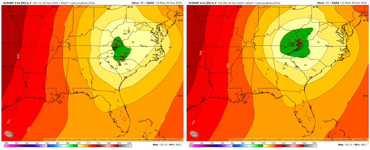
-
December 2020 Medium/Long Term Pattern Discussion.
Carvers Gap replied to John1122's topic in Tennessee Valley
That 12z run of the Euro...just want it to nudge just a bit more east of the Apps where it can consolidate (if you live in the E TN valley....stay where it is if in middle TN). The Apps disrupted the system quite a bit with that shift. There are times it shifts roughly 200 miles east. Problem is the slp gets disorganized so sometimes a shift is just a result of about three different low locations. -
December 2020 Medium/Long Term Pattern Discussion.
Carvers Gap replied to John1122's topic in Tennessee Valley
We might really not want that trend to continue at that increment...that is how much it moved. -
December 2020 Medium/Long Term Pattern Discussion.
Carvers Gap replied to John1122's topic in Tennessee Valley
12z Euro is east of its 0z run...sometimes well east. -
December 2020 Medium/Long Term Pattern Discussion.
Carvers Gap replied to John1122's topic in Tennessee Valley
Hour 192 snow accumulations on the CMC at Tropical Tidbits. This is from TWO systems... -
December 2020 Medium/Long Term Pattern Discussion.
Carvers Gap replied to John1122's topic in Tennessee Valley
Check out meteocentre. Not as good as yours, but gives you a heads-up. Will be interested to see the smaller time increments on the gif. -
December 2020 Medium/Long Term Pattern Discussion.
Carvers Gap replied to John1122's topic in Tennessee Valley
The UKMET at meteocentre looks slightly east. Biggest thing I notice is that the slp along the GOM is east on many of the models in the 12z suite. Some go the Miller A route while some lift due north. UKMET looks like it sent party of its low east of the Apps before heading straight to TRI form east central Alabama. Wrap around is wicked with the UKMET. -
December 2020 Medium/Long Term Pattern Discussion.
Carvers Gap replied to John1122's topic in Tennessee Valley
Agree. Storms like this wobble quite (with each run) a bit due to the phase being tough to model (timing and placement). The envelope right now, though trending slightly eastward, doesn't leave middle TN out of the game at all. I do think places like Monterey might be sitting pretty nice. For MBY, definitely hoping for an eastward jog...for yours I will be happy to see it jog back west. Hoping we can get accumulating snow in the forum area to start the season. -
December 2020 Medium/Long Term Pattern Discussion.
Carvers Gap replied to John1122's topic in Tennessee Valley
No problem! The 12z CMC really upped your totals in Corbin. Been interesting to watch. -
December 2020 Medium/Long Term Pattern Discussion.
Carvers Gap replied to John1122's topic in Tennessee Valley
Definitely like it! -
December 2020 Medium/Long Term Pattern Discussion.
Carvers Gap replied to John1122's topic in Tennessee Valley
Looks to me like that from is far enough south that it is causing a later phase. I always hold out hope(no matter how unfounded!) that he slp gets further east and pulls due north. Those traditionally are pretty good storms. Also of note, many of the models are popping a low now over Delmarva pretty consistently which is a pretty good sign of a strong storm. -
December 2020 Medium/Long Term Pattern Discussion.
Carvers Gap replied to John1122's topic in Tennessee Valley
At 42 the 12z CMC is south and east of its 0z run and slight weaker. Last comment on that model so as not to gum up the thread...trend south and east with it as well. -
December 2020 Medium/Long Term Pattern Discussion.
Carvers Gap replied to John1122's topic in Tennessee Valley
CMC at 24 is further south but looks like it has the ability to come north quite quickly from the Louisiana/TX border. -
December 2020 Medium/Long Term Pattern Discussion.
Carvers Gap replied to John1122's topic in Tennessee Valley
Can already tell the 12z CMC has initialed slightly quicker with the northern low in Alberta when compared to 0z. Edit: but the Holston's front is a hair further south. -
December 2020 Medium/Long Term Pattern Discussion.
Carvers Gap replied to John1122's topic in Tennessee Valley
12z CMC is now rolling. -
December 2020 Medium/Long Term Pattern Discussion.
Carvers Gap replied to John1122's topic in Tennessee Valley
Which model has that modeled the best? -
December 2020 Medium/Long Term Pattern Discussion.
Carvers Gap replied to John1122's topic in Tennessee Valley
Going to be a really good test of modeling with this system. Getting the phase right seems to be the hurdle. -
December 2020 Medium/Long Term Pattern Discussion.
Carvers Gap replied to John1122's topic in Tennessee Valley
Pretty much a great angle in terms of winds. -
December 2020 Medium/Long Term Pattern Discussion.
Carvers Gap replied to John1122's topic in Tennessee Valley
The 12z GFS is just weaker by a few mb. One can go to TT and toggle back about 5 runs from that point. You can see the system slide eastward every so slightly. Could it be a more progressive bias from the GFS? Maybe. That weaker solution is likely due to a later phase. This could still trend into a stronger system east of the Apps or it could just run the Apps. Lots of moving parts and interesting to watch.

