

Carvers Gap
-
Posts
17,470 -
Joined
-
Last visited
Content Type
Profiles
Blogs
Forums
American Weather
Media Demo
Store
Gallery
Everything posted by Carvers Gap
-

Christmas Eve/Christmas 2020 Arctic Express Snow Obs.
Carvers Gap replied to John1122's topic in Tennessee Valley
Another great resource from the NWS-MRX in regards to snow totals. I like this product.... https://noaa.maps.arcgis.com/apps/opsdashboard/index.html?fbclid=IwAR0QYePy3pyZYuuIS0jbRay_ZTOsakNgNxnZaAoB2TsaN0mHV2zxZ1c-btU#/4fe985838e464fb9bb980799443e01b6 -
January 2021 Medium/Longterm Pattern Discussion.
Carvers Gap replied to AMZ8990's topic in Tennessee Valley
Again, the 18z GEFS (or some variation) is a possibility for continued winter or a tough that extends from say Calgary to Kentucky. Those two set-ups have some prior precedent with a -NAO be a constant. -
January 2021 Medium/Longterm Pattern Discussion.
Carvers Gap replied to AMZ8990's topic in Tennessee Valley
Would about have to be...I think. -
January 2021 Medium/Longterm Pattern Discussion.
Carvers Gap replied to AMZ8990's topic in Tennessee Valley
The 18z CFSv2 Extended has flipped back to cooler for the last three weeks of January...but it has a much different MJO. Good point, @John1122. Yeah, this pattern would have been gold in Jan, @Daniel Boone. Let's hope this is one of these winters where the warm just never shows up in real time. It may well be that the pattern we move to would be that of 95-96(lite) where the cold stretches from MT to TN...models just aren't there yet. GEFS extended does hint at that after a couple of weeks of ridging in the East for weeks 2-3 of Jan. -
January 2021 Medium/Longterm Pattern Discussion.
Carvers Gap replied to AMZ8990's topic in Tennessee Valley
Yeah, the GEFS extended has flipped warm with a ridge along the eastern seaboard after the first week of Jan. I would imagine there would be intrusions of cold west of the Apps...colder the further west one goes. Maybe a Montana to Tennessee special at times. Overall, warm look(after Jan 7th) w a maybe one trough rolling through after the 7th. Pretty big changes, but it does bounce around some. -
January 2021 Medium/Longterm Pattern Discussion.
Carvers Gap replied to AMZ8990's topic in Tennessee Valley
See what you can find. Seems like opinions are split(pun intended) on whether this is good for eastern NA. Watching the GEFS extended run right now. Look like a very warm week 2 of Jan with some hope for week 3. Will update in a bit. Watching Liberty and Coastal Carolina. Thanks for your updates! -
January 2021 Medium/Longterm Pattern Discussion.
Carvers Gap replied to AMZ8990's topic in Tennessee Valley
Areas of "blue" for the SPV don't necessarily imply cold at the surface - sometimes it is the opposite right? I was looking at the GFS with its split at 18z....looks like the cold in NA is under the warmer strat anomalies. . 50mb will tell us a little better where the split goes, but for now...we need to be hoping this doesn't couple with the TPV IMHO. Again, there can be great years with TPVs and modeling could flip cold at the last minute. IMHO(and it is only an opinion) is that this SSW would not be an improvement to the pattern which we are currently in. It might be time to get my seed order prepped ASAP if this SSW goes the way I think it could. I will still hold out hope that it goes the way of some great winters. Be a tough pill to swallow if this SSW ruins this pattern. -
January 2021 Medium/Longterm Pattern Discussion.
Carvers Gap replied to AMZ8990's topic in Tennessee Valley
What we want to see is what the 18z GEFS did. The eastern ridge fires during week 2 of January, but a trough sneaks in underneath it. That allows a western ridge to fire. Once could imagine that allowing very cold air during the second half of January to slide into that trough. That said, I am not chasing cold into the second half of January this year. If it happens, it happens...but I won't be tracking that(not after last year's persistent fail on that). The worst case scenario is the 12z EPS and 12zCVSv2 extended....-NAO connects to an eastern ridge and never relents. Like Boone, runs counter-intuitive for a summer pattern to develop during winter, but I have seen it happen. However, La Nina climatology favors a trough in the West. Enough Grinch from me this evening. LOL. Needless to say, I don't like the trends after d10, but as we know...that can still change. This will flip quickly if it is going to change. That flip might not be seen for another week or two(speaking of cold if the split occurs). -
January 2021 Medium/Longterm Pattern Discussion.
Carvers Gap replied to AMZ8990's topic in Tennessee Valley
I think the 18-19 coupled with the TPV - is that the year we got the twin vortices or was that last year? ....Very much looks like the lobes of the TPVs go to western Europe and the other rotates into Alasks(and then retrogrades back into eastern Siberia). I really cannot overstate my disdain for what I am seeing with this SSW. Ugh. -
January 2021 Medium/Longterm Pattern Discussion.
Carvers Gap replied to AMZ8990's topic in Tennessee Valley
SSW is going to be a real pain in the butt from a model standpoint. The GFS successfully forecast an SSW split in March of 2018 from 16 days out. March was frigid. Think the following winter (18-19), we had a good pattern forecast at some point that winter...the SSW "split" and we lost that look in the LR. We had a great start to winter in 2018 here in TRI, and then the pattern evaporated. All of that said, early season strat splits in late December and early January have led to some great winter patterns in the East which featured very abrupt changes. Right now, we are about to substitute a decent pattern(like early Dec 2018) for one that could be great or could be spring. I have seen modeling flip on a dime to really cold or really warm. They are quite random in where they place the lobes of cold which break off - like going to Vegas. I really don't like the trends of LR modeling during the past 36 hours. They could flip back once the strat warm is "felt," but I lost my enjoyment of SSW stuff in 18-19. LOL. Give me March 2018 in January...but not a fan of LR modeling trends right now. That said, if the SSW is going to be felt, count forward a couple of weeks from the SPV split(assuming the TPV also splits), and that should be when we see changes at our latitude. @Holston_River_Rambler, when is the exact time frame of that split. -
Christmas Eve/Christmas 2020 Arctic Express Snow Obs.
Carvers Gap replied to John1122's topic in Tennessee Valley
Bays Mountain Park in Kingsport. Some of the "peaks" there are 2,280-2,400(max) feet. Pretty cool place. There is actually an elevated valley in the middle of two ridges - pretty rare geological formation(valley in the top of a mountain). Just looks like one ridge as you drive by on I-26. It used to be Kingsport's water supply. We were at about 2,000' in the phot. Great place to ride mountain bikes, run, or hike. Also has a nice nature center and planetarium. Most of the arms of the lake were ice covered today. -
Christmas Eve/Christmas 2020 Arctic Express Snow Obs.
Carvers Gap replied to John1122's topic in Tennessee Valley
Headed up to Bays Mountain today for a run(SLOW!) in the snow. Went through anywhere from 3-7" of snow. Got a lot of good climbing in though.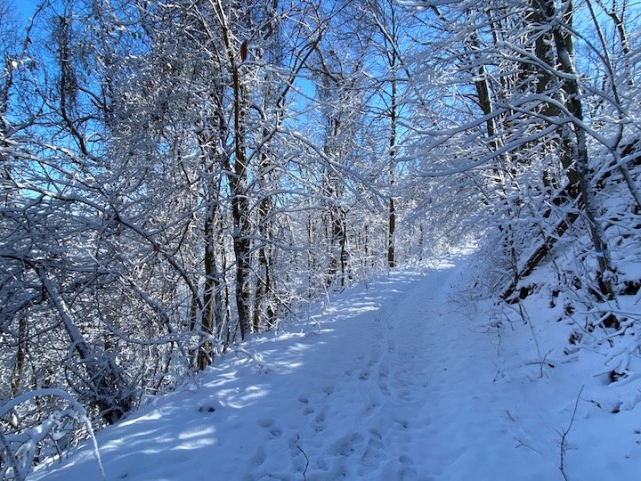
-
January 2021 Medium/Longterm Pattern Discussion.
Carvers Gap replied to AMZ8990's topic in Tennessee Valley
After a decade and a half of really bad winters, the Mountain West had some great winters in the 2010s...stellar type stuff. -
January 2021 Medium/Longterm Pattern Discussion.
Carvers Gap replied to AMZ8990's topic in Tennessee Valley
Can't remember. We had one winter where it was pushed back and pushed back...then had an and SSW...and had more snow in March than the rest of winter. I am thinking this(the one where the SSW screwed things up) was 17-18 when we had that really cold last half of December. Then, it went to crap. LOL. That said, some truly great winters have had SSWs during early January. -
January 2021 Medium/Longterm Pattern Discussion.
Carvers Gap replied to AMZ8990's topic in Tennessee Valley
Saw a post on another forum(maybe MA), where the strat warm stuff may be causing some of this for early January modeling. Seems like 2-3 winters ago, we had a January that looked great on LR modeling, and the strat warm pretty much wrecked havoc on that. Makes me wonder if we are about to see large scale changes(could be really good or the opposite) after mid-January. The SSW could have a hand in that look as well. Ah, I remember now(forgive the stream of thought post!)...the MA referenced a tweet about the eastern US being warmer than normal during the events leading up to a strat warm. LOL- heck, I have even talked about it, but always forget when it happens in modeling. When there is a massive ridge along the east coast of NA(basically a WAR on steroids...talking like Cuba to Greenland), that has preceded the last 2-3 SPV splits. Have to admit, I am not excited about this strat split scenario...but it does open the door for very cold air(due to the NAO) to enter the east after the split. Just going to depend on which side of the globe the coldest air goes. -
January 2021 Medium/Longterm Pattern Discussion.
Carvers Gap replied to AMZ8990's topic in Tennessee Valley
12z CMC has snow in Kansas. True cutter. -
January 2021 Medium/Longterm Pattern Discussion.
Carvers Gap replied to AMZ8990's topic in Tennessee Valley
The fly in the ointment with this storm is the high near Bermuda is not getting out of the way. It is creating return flow over the SE. -
January 2021 Medium/Longterm Pattern Discussion.
Carvers Gap replied to AMZ8990's topic in Tennessee Valley
My only concern with the GFS is how quickly it is moving its snow axis westward. During the last four runs, it has moved from eastern W VA to Lexington, KY, at that latitude. Would be nice to see it settle on a track. Let's see where the CMC goes. -
January 2021 Medium/Longterm Pattern Discussion.
Carvers Gap replied to AMZ8990's topic in Tennessee Valley
Just digging through modeling this morning. Here is the 6z Euro Control. @Holston_River_Rambler, I don't think the operational goes out to 144 and neither the ensemble nor deterministic have precip types at 6z, right? Either way, this is a good look eastern section of middle TN and mirrors the 6z GFS. -
January 2021 Medium/Longterm Pattern Discussion.
Carvers Gap replied to AMZ8990's topic in Tennessee Valley
I think anytime we have a strong fold front on modeling (during the next couple of weeks), going to have to be watched. -
January 2021 Medium/Longterm Pattern Discussion.
Carvers Gap replied to AMZ8990's topic in Tennessee Valley
As for the 6z GFS, going to need other modeling come east as the GFS is on the eastern side of the envelope (and trended westward at 6z) for the NYE storm. Still a long way to go on that one. We were fortunate to track the Christmas Eve deal from almost ten days - that is a rarity. The pattern does support 1-2 storms taking the low road during that time frame. The storm immediately after the NYE storm is kind of what I am watching. -
January 2021 Medium/Longterm Pattern Discussion.
Carvers Gap replied to AMZ8990's topic in Tennessee Valley
The CFSv2 seasonal(which bounces around and changes quite a bit as it runs once per day) illustrates the concern for January, and also illustrates how a -NAO can create a ridge in the East. I think we will see an undetermined period of the look below - might be just a few days, a week, or weeks. Just tough to tell. We are now entering that time frame that is one where I have low confidence as modeling is juggling several plates(see my posts yesterday). The GEFS OLR maps today do depict convection in the IO(Inidan Ocean) region in the phases 3-4 regions and maybe some weaker convection in the phases 1-2 regions as well. We don't want that showing up long term as one only needs to look to last winter to see the consequences of that. The run below kind of shows what modeling is dealing with. The 0z EPS now has a similar look to what is below. The variability is possibly due to the MJO becoming possibly becoming more of a factor on some modeling and even during various model runs...and less on others. What all of this means is that the Atlantic(-NAO) is going to have to be the driver in the LR if we want more cold and snow after the New Year and little help from the Pacific is on the Horizon....and the Atlantic, if too strong, can actually become a thorn as well. Finally, let's see where the EPS goes(the 6z GEFS implies the ridge). I don't like losing it in the LR. Just one run of the EPS which looks bad, so let's see where it goes. Indeed, the 6z GFS has a similar set-up to the Christmas Eve event. The Euro is basically a cutter for that event. CMC is in between the Euro and GFS. Canadian modeling has been pretty good this winter. The window from NYE to maybe around Jan 4th has some potential for the subform. After that time frame...toss-up.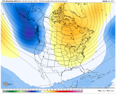
-
Christmas Eve/Christmas 2020 Arctic Express Snow Obs.
Carvers Gap replied to John1122's topic in Tennessee Valley
-
December 2020 Medium/Long Term Pattern Discussion.
Carvers Gap replied to John1122's topic in Tennessee Valley
Definitely an interesting time for sure. Thanks for the data. Yeah, it looks almost like the same set-up. Would be the third one this month of that type - old school right there. Used to happen way back...not as much these days. I wonder with the -NAO if it is slowing systems down enough that the cold catches the precip...have to think it has something to do with the block. -
December 2020 Medium/Long Term Pattern Discussion.
Carvers Gap replied to John1122's topic in Tennessee Valley
Just digging back through this thread, the GFS and Euro almost nailed this from ten days out. My big take away is that Arctic fronts bring good things(this year anyway) if they are real on modeling. So, we can’t tuck that one away in case we see a similar setup again this winter, and I would guess we might.

