

Carvers Gap
-
Posts
17,470 -
Joined
-
Last visited
Content Type
Profiles
Blogs
Forums
American Weather
Media Demo
Store
Gallery
Everything posted by Carvers Gap
-

Dandridge Dollop 12/24/20 Storm Thread (Winter Wonderland)
Carvers Gap replied to AMZ8990's topic in Tennessee Valley
17z HRRR is backing down a hair, but yeah...we roll with that right now!!!- 847 replies
-
- 1
-

-
- cold temperatures
- snow
- (and 8 more)
-
Dandridge Dollop 12/24/20 Storm Thread (Winter Wonderland)
Carvers Gap replied to AMZ8990's topic in Tennessee Valley
Have to get all of the way to the end of that run. Lots more snow fell after that image. Fingers crossed, Jed!- 847 replies
-
- 2
-
-
- cold temperatures
- snow
- (and 8 more)
-
Dandridge Dollop 12/24/20 Storm Thread (Winter Wonderland)
Carvers Gap replied to AMZ8990's topic in Tennessee Valley
Euro Kuchera...shift east a hair with heavier snow. Final run before the modeled storm.- 847 replies
-
- 1
-
-
- cold temperatures
- snow
- (and 8 more)
-
Christmas Eve/Christmas 2020 Arctic Express Snow Obs.
Carvers Gap replied to John1122's topic in Tennessee Valley
Well, time to go running...this is gonna be a slog. Moderate rain. Been trying to get up the nerve or about two hours. LOL. -
Dandridge Dollop 12/24/20 Storm Thread (Winter Wonderland)
Carvers Gap replied to AMZ8990's topic in Tennessee Valley
15z HRRR( @Reb mentioned the HRRR trends earlier) has really beefed up in comparison to 12z. I am about out of memory space, but a Kuchera Ratio from 12z(full run) and 15z(full run) would be interesting to look at at the trend. Even comparing the same time of day is impressive.- 847 replies
-
- 1
-
-
- cold temperatures
- snow
- (and 8 more)
-
Dandridge Dollop 12/24/20 Storm Thread (Winter Wonderland)
Carvers Gap replied to AMZ8990's topic in Tennessee Valley
MRX update...9:49AM .DISCUSSION... The main change for the morning update will be to end the Wind Advisory and High Wind Warning, as obs around the area show wind gusts falling below criteria in the last few hours. The forecast for snowfall this afternoon still appears on track, as the latest model guidance shows a changeover to snow starting in the Plateau between 1-2 PM, in the TN Valley between 2-4 PM, and in NE TN/SW VA between 4-6 PM. Behind this transition zone, there will be a 3-4 hour period where snowfall rates could be high, around an inch per hour possible with localized snow bands producing even higher rates. Steep low level lapse rates and some low level CAPE around 175 J/kg may even produce some thundersnow in NE TN/SW VA around 4-6 pm, as shown by the HRRR. Travel conditions will deteriorate quickly during and in the hours after the transition to snow. The forecast snow accumulations and the W/W/A products will not be changed at this time.- 847 replies
-
- 4
-
-
- cold temperatures
- snow
- (and 8 more)
-
Dandridge Dollop 12/24/20 Storm Thread (Winter Wonderland)
Carvers Gap replied to AMZ8990's topic in Tennessee Valley
LOL. I thought about it - very briefly. By the time it starts snowing there...not sure I can make it back to TRI. Might try to swing up there Saturday if roads permit. I suspect(if this verifies), they may have near blizzard conditions overnight and into early tomorrow. I have great respect for how bad the weather can get there...My scout troop (the year prior to me joining way back when) went up to the first bald to camp. There are stories that they couldn't hold their tents down(tents today are much more suitable for higher winds). About halfway through the night in howling winds and rain, they packed up and walked back to Carvers Gap to whatever transportation they had - not sure if they slept in the van or came home that night. These were pretty savvy kids and wouldn't normally pack-up...I have been up there a few times after big snow storms - waist deep drifts type stuff. White knuckle stuff coming back down. The road up to the gap(not sure if you have been) is on the shady side of the mountain. So, it gets super icy.- 847 replies
-
- 6
-
-
- cold temperatures
- snow
- (and 8 more)
-
Dandridge Dollop 12/24/20 Storm Thread (Winter Wonderland)
Carvers Gap replied to AMZ8990's topic in Tennessee Valley
Definitely a westward expansion of snow on the 12z GFS, especially important for those along I-75 in John's neck of the woods and London/Corbin.- 847 replies
-
- 2
-
-
- cold temperatures
- snow
- (and 8 more)
-
Dandridge Dollop 12/24/20 Storm Thread (Winter Wonderland)
Carvers Gap replied to AMZ8990's topic in Tennessee Valley
12z GFS looks very similar to 6z. By the time it runs again, this event will be under way. So, that is basically its last run(with the totality of the event) for folks to the west of TRI. -
Dandridge Dollop 12/24/20 Storm Thread (Winter Wonderland)
Carvers Gap replied to AMZ8990's topic in Tennessee Valley
Pretty crazy. You can see the convective snow bands in the RGEM above. Some of those bands are picking up very light traces of snow into southern parts of Georgia. -
Dandridge Dollop 12/24/20 Storm Thread (Winter Wonderland)
Carvers Gap replied to AMZ8990's topic in Tennessee Valley
12z RGEM...- 847 replies
-
- 1
-
-
- cold temperatures
- snow
- (and 8 more)
-
Dandridge Dollop 12/24/20 Storm Thread (Winter Wonderland)
Carvers Gap replied to AMZ8990's topic in Tennessee Valley
How does the Kuchera look? -
Dandridge Dollop 12/24/20 Storm Thread (Winter Wonderland)
Carvers Gap replied to AMZ8990's topic in Tennessee Valley
12z RGEM looks like it is super similar... -
Dandridge Dollop 12/24/20 Storm Thread (Winter Wonderland)
Carvers Gap replied to AMZ8990's topic in Tennessee Valley
Great catch. You can see it on the 500 vort map. Never would have noticed it on the 3k NAM.- 847 replies
-
- 1
-
-
- cold temperatures
- snow
- (and 8 more)
-
Dandridge Dollop 12/24/20 Storm Thread (Winter Wonderland)
Carvers Gap replied to AMZ8990's topic in Tennessee Valley
Yeah, that upped the totals over the areas some.- 847 replies
-
- 1
-
-
- cold temperatures
- snow
- (and 8 more)
-
Dandridge Dollop 12/24/20 Storm Thread (Winter Wonderland)
Carvers Gap replied to AMZ8990's topic in Tennessee Valley
Looks like the NAM(3K and 12k) are a very slight tick west of their previous runs. I like that trend west, because I don't like seeing storms begin to slide eastward on modeling.- 847 replies
-
- 1
-

-
- cold temperatures
- snow
- (and 8 more)
-
Dandridge Dollop 12/24/20 Storm Thread (Winter Wonderland)
Carvers Gap replied to AMZ8990's topic in Tennessee Valley
12z NAM is running. Both the 12k and 3K look good. Overall setup is still the same. 12K is slightly less. The 3k NAM is pretty amazing to watch. Some of us started doing this when pixels might be 50-100k. So seeing a storm in 3K is pretty awesome. Looks like it held for you Knoxvvile folks. -
Dandridge Dollop 12/24/20 Storm Thread (Winter Wonderland)
Carvers Gap replied to AMZ8990's topic in Tennessee Valley
Kuchera Euro 0z...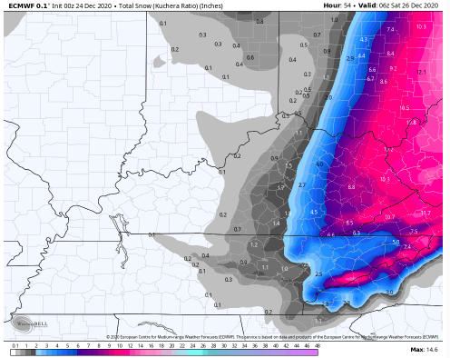
- 847 replies
-
- 4
-
-
-
- cold temperatures
- snow
- (and 8 more)
-
Dandridge Dollop 12/24/20 Storm Thread (Winter Wonderland)
Carvers Gap replied to AMZ8990's topic in Tennessee Valley
Looking like the Euro will hold serve. Haven't seen accumulations, but evolution of the system appears very similar. Only thing of concern, the actual weather on the ground appears much quicker (as 1234 noted) than modeling is grasping. -
Dandridge Dollop 12/24/20 Storm Thread (Winter Wonderland)
Carvers Gap replied to AMZ8990's topic in Tennessee Valley
Christmas Eve 0z Euro is rolling....- 847 replies
-
- 1
-
-
- cold temperatures
- snow
- (and 8 more)
-
Dandridge Dollop 12/24/20 Storm Thread (Winter Wonderland)
Carvers Gap replied to AMZ8990's topic in Tennessee Valley
Seems much faster than predicted... UKMET...pretty good step back which might reflect that concern. UK has admittedly been consistently the weakest of most modeling. -
Dandridge Dollop 12/24/20 Storm Thread (Winter Wonderland)
Carvers Gap replied to AMZ8990's topic in Tennessee Valley
10:45 MRX Updtate... .DISCUSSION... Showers have increased dramatically across middle Tennessee ahead of mid level trough as intense low pressure area over the western Great Lakes moves into southern Canada and the associated cold front is now moving into west Tennessee late this evening. A line of showers and thunderstorms was moving through west Tennessee at this time. Strong south to southeast winds from the pressure gradient from higher pressure over western North Carolina to the lower pressure west of the eastern mountains was producing wind gusts already above 60 mph and winds to around 35 to 40 mph have occurred in isolated spots in the valley. Have sped up timing of the higher pops slightly with update from southwest to northeast and bumped lows up a degree or two over southern and central valley. Temperatures are being held up in many places by the winds and lows may have already occurred over the northeast half of the area...or will occur around sunrise when cold front moves through western sections of the forecast area. Updated forecast sent. Will update WSW and SPS products shortly.- 847 replies
-
- 1
-
-
- cold temperatures
- snow
- (and 8 more)
-
Dandridge Dollop 12/24/20 Storm Thread (Winter Wonderland)
Carvers Gap replied to AMZ8990's topic in Tennessee Valley
FWIW, the 0z GEFS ensemble mean is a pretty decent improvement from 18z.- 847 replies
-
- 4
-
-
- cold temperatures
- snow
- (and 8 more)
-
December 2020 Medium/Long Term Pattern Discussion.
Carvers Gap replied to John1122's topic in Tennessee Valley
Not saying this is going to happen, bu the GEFS extended which comes out each evening was really a great looking pattern for much of its run. -
Dandridge Dollop 12/24/20 Storm Thread (Winter Wonderland)
Carvers Gap replied to AMZ8990's topic in Tennessee Valley
...And when I say "holds serve," I generally mean the storm is still there, trends haven't completely altered the idea of where the storm was depicted during previous runs, the synoptic set-up is still pretty much the same, and accumulations are generally where they were placed during the previous runs. Looks like the CMC might have indeed shaved some off the southwest edge near south/middle TN. Overall, the look is pretty similar on the 0z CMC.- 847 replies
-
- 2
-
-
- cold temperatures
- snow
- (and 8 more)