

Carvers Gap
-
Posts
17,457 -
Joined
-
Last visited
Content Type
Profiles
Blogs
Forums
American Weather
Media Demo
Store
Gallery
Everything posted by Carvers Gap
-

January 2021 Medium/Longterm Pattern Discussion.
Carvers Gap replied to AMZ8990's topic in Tennessee Valley
And I will add, this winter was supposed to be a huge nothing burger. It was forecast by many to be wall-to-wall torch. I think we have 4 winter threads so far, including a Christmas Eve storm(the Holy Grail of storm tracking) which was nailed at range. And certainly this has not been great for everyone, and I have no control over that. However, that does not mean this winter is a fail by any means in some areas. The mountain behind my house has had snow on it since Christmas on most days - it is only 2,400'. The NAO has saved us from much AN temps. It is very important to remember that the Nina is fading. So it is important to think about what modeling is juggling right now: fading Nina, yet another SSW, and an unexpected NAO - not to mention analog packages are few. I think the pattern which has persisted much of winter is periodic, seasonal cold that has brought snow chances with each surge of cold. But make no mistake, modeling is bouncing around right now. HOWEVER, modeling has generally gotten the overall progression(or should I say retrogression?) of the January pattern overall. I should add that the 12z CFSv2 supports the 12z Euro control. I am not confident that anything past d10 is accurate at this point, but I do think the West is about to get their share of winter. -
January 2021 Medium/Longterm Pattern Discussion.
Carvers Gap replied to AMZ8990's topic in Tennessee Valley
The 12z EPS control shows the quick way to get to a monster EPO/PNA ridge around d11. Not saying that happens, but if the MJO can swing into 8 while the NAO persists...that is the outcome. Just don't think modeling has this worked out yet - some great options on the table and some "get your garden" ready options as well. -
January 2021 Medium/Longterm Pattern Discussion.
Carvers Gap replied to AMZ8990's topic in Tennessee Valley
The linkage from the NAO to the SE has been shown nearly the entire first half of winter and has rarely verified. So, I have my doubts at to how persistent that will be, but glad it was mentioned. I have been watching if for several runs. Could it last for weeks on end? Sure, but I have doubts about that. We have talked about the SER/NAO link off-and-on at times so far. Just looking at the 12z EPS, looks to me like the trough will retrograde through the west and eventually form a GOA low - which is not great but no a deal killer. I still think modeling is really struggling with the NAO which simply seems to have no intention of going away - yet. As I noted in late December, we are entering a time of great uncertainty - and still are. My guess? The trough retrogrades slowly, a PNA pops, and back in business by the second week of Feb. So, cold shot Jan 25-30th, one week ridge, and back to a trough by the second week of Feb. The CFSv2 has handled that really well. Keep an eye on the MJO. I have often wondered if the NAO could bridge us to a better Pacific. It may be doing just that. If you watch the 12z GFS, the eastern ridge amplifies and retrogrades west with each amplification - to the point it is in the eastern Pacific by d13+. Add in that LR modeling is all over the place right now...going to take a wild guess that another SSW is under way or about to be. -
January 2021 Medium/Longterm Pattern Discussion.
Carvers Gap replied to AMZ8990's topic in Tennessee Valley
Not overly fond of model trends during the past 12 hours regarding the LR. That said, the CA OLR and GEFS OLR which we can use to predict the MJO are again strongly hinting that the MJO is about to propagate into 7 and likely 8. That would mean that help from the Pacific would possibly occur between d10-20. Let's see if modeling, especially the GEFS begins to correct to that. If true, that would open the doors to very cold air in the eastern US. Not saying that happens as the MJO could get stuck in 7 and the cold get bottled up in the Canadian front range....but something to think about. -
January 2021 Medium/Longterm Pattern Discussion.
Carvers Gap replied to AMZ8990's topic in Tennessee Valley
Still seeing signs of cross polar flow on the GFS - quite impressive. -
January 2021 Medium/Longterm Pattern Discussion.
Carvers Gap replied to AMZ8990's topic in Tennessee Valley
Great catch, man. Glad you shared that. From this AM, the CA OLR maps (which have been wrong before) show the precip propagating into 7/8. Seeing some hints of the pattern on the CFSv2 showing the EPO return on the 12z run today. The GEFS OLR is hinting at that move - at least showing the IO become less. That would fit what we are seeing past d10+. -
January 2021 Medium/Longterm Pattern Discussion.
Carvers Gap replied to AMZ8990's topic in Tennessee Valley
Couple of notes before going out running in this mess. 12z CMC is picking up on the potential for next weekend's system. The 12z GFS is freakin' cold. -
January 2021 Medium/Longterm Pattern Discussion.
Carvers Gap replied to AMZ8990's topic in Tennessee Valley
0z Euro has 1-2" of snow for NE TN on the 23rd, and has snow for the Plateau and mountains - was a nice look. Looks like TYS to the NE got snow on that run around 168. As John noted, the 6z GFS looked good as well. -
Light dusting here. Light snow falling.
-
January 2021 Medium/Longterm Pattern Discussion.
Carvers Gap replied to AMZ8990's topic in Tennessee Valley
12z EPS is likely the coldest I have seen it for the d10-15 in a long time - some 13 degree BN departures over this forum area....in January that is COLD. -
January 2021 Medium/Longterm Pattern Discussion.
Carvers Gap replied to AMZ8990's topic in Tennessee Valley
The 12z GFS is how things could go badly and does not have support from the GEFS. The 12z para-GFS is how things could go well. -
January 2021 Medium/Longterm Pattern Discussion.
Carvers Gap replied to AMZ8990's topic in Tennessee Valley
The much advertised "flip" to cold over NA is very stark when one looks at d1 and d10. Features a nearly complete reversal of AN temp anomalies. Hoping that is legit and doesn't just park itself in the West. The good thing is that "flip" is moving forward in time. -
January 2021 Medium/Longterm Pattern Discussion.
Carvers Gap replied to AMZ8990's topic in Tennessee Valley
12z GEFS is also pretty much locked onto the timeframe just after the 25th. If real(and we all know the rules about 10+day discussions), would be a very good potential window for the return of more widespread winter precip. That is the set-up that looks like 96. The ridge retrogrades westward next week, and the trough forms in its wake. The 12z CMC is a bit faster with that look as it retrogrades(see post above) cold in from eastern Canada. -
January 2021 Medium/Longterm Pattern Discussion.
Carvers Gap replied to AMZ8990's topic in Tennessee Valley
We have only had eight days below freezing at TRI for January. We have had zero days with highs below freezing. Again, really feel like this is 89 battling 95-96 - both were extremes. Does sort of seem like warmer solutions are "winning" in modeling right now, but with that Greenland block in place I suspect we still have some cold to work with. Seems like the next cold shot(after this weekend's) is due just after the 25th. Looks ripe for mischief about then - if real. The 0z EPS was quite cold after d10, especially when it tends to have a warm bias in that range. Will be interesting to see if it holds that look at 12z as 0z was nearly perfect for sliders and systems attacking cold which extends from the Mountain West into the Southern Apps. Let's hope it doesn't keep getting pushed back. It is probably about three days later than forecast last week(off the top of my head), but still clearly on the overnight run of the EPS. -
January 2021 Medium/Longterm Pattern Discussion.
Carvers Gap replied to AMZ8990's topic in Tennessee Valley
Would have been torch city with no NAO. As is, what is crazy is that pretty much anytime we are seeing any type of cold, areas about 3K' are seeing frozen precip - even though most of the subform is well AN for January in regards to temps. -
January 2021 Medium/Longterm Pattern Discussion.
Carvers Gap replied to AMZ8990's topic in Tennessee Valley
Something interesting to watch...the 12z CMC actually has a backdoor cold front. Used to see those often, but not so much of recent. Just use Tropical Tidbits and toggle over to temp anomalies. Then, watch the temps move from the NE to SW after 200. You can see the retrograding pattern with surface temps. 12z GFS looks entirely too progressive to me FWIW. -
January 2021 Medium/Longterm Pattern Discussion.
Carvers Gap replied to AMZ8990's topic in Tennessee Valley
12z CMC again shows a mess around 200 with a slider and some WAA characteristics rolled into one. Looks like we get a cold shot this weekend, then a retrograding ridge moving from east to west, and then the growing potential of another cold shot that slips in as the ridge moves westward into TX and/or the Southwest. That second cold shot looks very promising. Models still very much struggling with a lousy Pacific battling the -NAO which has continued to be persistent this winter(surprisingly so!!!). Strong cold signal for the Mountain West which is of zero surprise, and then we get periodic shots of cold. -
Some sleet falling now.
-
January 2021 Medium/Longterm Pattern Discussion.
Carvers Gap replied to AMZ8990's topic in Tennessee Valley
One rule of thumb is that clippers really like to pull north as the event gets closer. There are certainly notable exceptions to the rule, but normally we want that clipper going well south. -
January 2021 Medium/Longterm Pattern Discussion.
Carvers Gap replied to AMZ8990's topic in Tennessee Valley
Yeah, good find. When the EPS is cold after d10, that would likely verify much colder if true. BN temps in Jan are cold! Certainly looks like the strat stuff is showing up. Modeling has a tendency to change quite quickly once those effects get to our latitude. Guessing this is as a result of the early Jan SSW but not certain. I “think” there is another perturbation(think that is a word?) later this month, so modeling could be sensing that. But with the GFS last week really getting this cold back into Canada, makes me think this is due to the early Jan SSW. With such a sudden reversal in the lower 48, really seems like SSW stuff...now, let’s just hope this stuff doesn’t hold in the West like what occurred in Nov. I think this time around the -NAO likely forces the flow into the East this time after if first ventures into the West. -
January 2021 Medium/Longterm Pattern Discussion.
Carvers Gap replied to AMZ8990's topic in Tennessee Valley
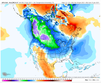
The GEFS Extended from yesterday shows the reversal which is modeled to occur over Canada. This reversal has been accurately modeled for a couple of weeks. The cold lifted out of Canada last weekend, but check this out. First image is the 13-20th. Second image is 24-31st. Very cold air spills into western Canada. I think Holston's SSW previous discussions have merit. If those two maps verify, IMHO that is the direct result of the SSW. I am seeing ensembles move to this look at 12z today, especially the GEPS and GEFS. The SSW has basically displaced lots of cold off the pole. I agree with John that the NAO is likely being augmented by the strat stuff. Modeling has been trending towards this look for about the past 36 hours.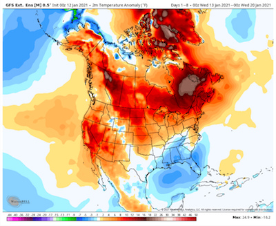
-
January 2021 Medium/Longterm Pattern Discussion.
Carvers Gap replied to AMZ8990's topic in Tennessee Valley
I don't consider the 12z GEFS and 12z GEPS ensembles to be particularly warm. Additionally, the 12z EPS has adjusted post 300 towards the GEFS. The ridge which was setting up shop in the East in the LR(on modeling a few days ago and had been a mainstay for several days) is now projected to retrograde into the Southwest and create a very typical Nina pattern with cold stretching from Calgary to the TN Valley region. That ridge at one point was set to connect with the NAO and be quite strong. Then, it was going to retrograde into the West, but come back East. As it is right now, we may bet backdoored with BN heights coming in from the Atlantic of all places as the pattern continues to retrograde at our latitude. While our weather is coming from the west obviously, the 500 pattern is quite another setup altogether. IMHO, this is potentially setting up concern for an ice storm due to overrunning. Basically, the cold will periodically surge into this area. With an active southern jet, the cold will potentially get trapped at some point as WAA overruns it. You can see very clearly that the 12z Euro operational almost does this. That has a lot of 95-96 in it. So, interesting to see modeling yet again pushing back a warm pattern. BTW, the MJO continues to look better today. IF the Pacific can be of any support, the East will get cold very quickly as it appears cold is now modeled to enter into western Canada and spread eastward. The 12z GEFS is a great illustration of this. Of course, we could get some unwanted Pac air at times, but I would suggest that our source region for cold is about to be quiet cold. I echo Met85 from the SE forum, great discussion. -
January 2021 Medium/Longterm Pattern Discussion.
Carvers Gap replied to AMZ8990's topic in Tennessee Valley
The real question in my mind is how far does the cold push. A great example is to look at the 6z GEFS and 0z GEPS temp anomalies. Both have a classic La Nina cold set up. One pushes the cold into the SE and one does not. I suspect we see a blend of those two models. -
January 2021 Medium/Longterm Pattern Discussion.
Carvers Gap replied to AMZ8990's topic in Tennessee Valley
Not sure that the pattern simply doesn't revert back to the pattern that we had during the last 1/3 of December. During years where La Nina winters are cold(there are some warm ones as well if the Nina is moderate to strong), the cold stretches from the Mountain West to the southern Apps and/or MidWest. Starting to see the end of the month ridge get pushed back - no surprise. I think right now we have an unfavorable Pacific battling the NAO. So far, that has produced four sub-forum events since early December. I have no crystal ball, but I suspect we continue to see chances through at least the first week of Feb. Interestingly, wx Modeling actually has been correct about the warm-up which was predicted for January. TRI is a whopping +4.2F for the month so far and only two days with BN temps. That said, Kingsport has received roughly 4" of snow during that time frame. That is what a -NAO does, even if it doesn't have a ton of cold. NAOs often produce the right confluence combination here. It is almost as if 89-90 and 95-96 are battling it out. As Holston noted, we should be cautious in embracing any dry spell. It may happen, but when modeling shows abundant cold with no precip - very unlikely that combination occurs due to a very active precip pattern. Pretty much each time that we have seen a cold front, frozen precip has followed. So, I think the key is to identify cold air(even if marginal). That cold, in conjunction with a very active southern stream, has the potential to produce wintery precip for the area. Some years we get cold, and don't have an active southern stream...hence the phrase cold and dry. This year just seems the potential for cold and precip to merge is much higher. That is likely due to the NAO slowing systems down over this region. -
January 2021 Medium/Longterm Pattern Discussion.
Carvers Gap replied to AMZ8990's topic in Tennessee Valley
It has been my observation that when a bunch of weak systems are running around, models tend to miss phases/partial phases at the 6-7 day range. Wouldn't be surprised to see a model grab one of those pieces of energy, and spin it up.


