

Carvers Gap
-
Posts
17,456 -
Joined
-
Last visited
Content Type
Profiles
Blogs
Forums
American Weather
Media Demo
Store
Gallery
Everything posted by Carvers Gap
-
 Thanks, Math/Met! Thankfully, the actual content(potential cold wx) is interesting right now. Honestly, just really thankful to see our board expand and still maintain such great content. We have so many great posters. I am always hugely appreciative of the contributions of the meteorologist on this forum. Just a small example, I had almost no idea that we had mountain wave events in this area until you started posting about them. Great team effort here by so many. Thank you again!
 -
One quick correction. The most severe cold on the EPS does indeed bank briefly along the front range of MT before heading south and east. So, while we thought the Jan25-30 time frame might have some similarities to 95-96, we are now actually within 100 hours of a similar temp configuration (NW to SE band of cold temps across NA) coming to fruition. IF the EPS is correct, that temp configuration lasts from Feb 5 to Feb 18. We really can't ask for a better look on modeling and it is well within range now. We have noted often how this La Nina has elements of both '89 and '96. January at TRI finished 2.7 AN re: temps. What is being modeled is nearly opposite of that warm spell during January. Exciting times. This is why we do this. Might we strike out? Sure! That is just life in the Upper South. But history does show that sometimes we can do well with this type of pattern. Time will tell. Just enjoy the ride.
-
Here is the 12z EPS MSLP(mean sea level pressure for 240). So, just trying to see if the ensemble matches the operational. Looks pretty good, but more eastward with the core of the cold. The ensemble supports the UKMET operational actually. It does not bottle the cold up in MT. This is a great winter storm pattern IF it verifies, and IF we can get precip to time with the onset of the cold. Again, the slower this front moves...the better chance we get OR we get a higher frequency of systems from the southern stream. The ideal situation is that the front sages south of our area and stalls. If the SER fights(and it should), that would send multiple waves of precip along this cold air boundary - reference the blue arrow. My interest is in getting the pattern right - for now. I know we all love great snow maps, but that is a good look below. IF we can reel that in, that is the key... I think yesterday's snow map on the 12z Euro was just a warning shot by the model that things might get interesting. FTR, this might be 240 on the EPS, but the actual pattern(not to this extreme) begins about 132. We have seen this look past d10 multiple times this winter and it did not verify. I like right now that we are seeing this now in a 5-10 day depiction.
-
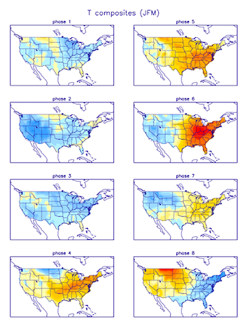
Pretty much a cage match between the MJO vs the NAO vs the SSW vs changing wavelengths of the season. MJO phase 7 centered on JFM is warmish over the East. Notice the severe cold over MT which fits the above maps. Thing is, the NAO is going to try to press that cold eastward with suppressed flow - will agitate that MT cold if you will. https://www.cpc.ncep.noaa.gov/products/precip/CWlink/MJO/Composites/Temperature/
-
This is 144 on the 12z UKMET. That is -47F stuff in Iowa. Models "seem" to be signaling a major cold outbreak. Timing is EVERYTHING in regards to if/when the cold arrives and if it the southern stream will attack it(which I think it would). The Euro is pretty much the best solution as I look at the 12z suite. Yes, it is slower with the cold...but it holds the cold in the Plains. If that cold slides into the Midwest - it will be a major news story because of the cold and not snow. If it holds in the front range of MT and slowly heads SE(key being SLOW), that gives multiple piece of energy a chance to attack that incoming cold. Pretty much all modeling is showing severe cold...UKMET, Euro, GFS, and CMC. Duration, location of the worst of it, and extremes TBD. Sorry for the small thumbnail...had to resize it. Pivotal has the actual model run.
-
Really, after 100...The Euro is not too dissimilar to this 240 slide. Again, no reason to take a 240 slide verbatim. Simply showing the potential. The 12z UKMET was pretty much this cold at 144. I am just showing this so you all can see an expanded view of the MT cold with actual temps and not anomalies. That set-up is why we had such huge snow totals on yesterday's run at 12z on the Euro. The setup is still there, but the timing is different due to the range. D5-10 stuff is absolutely going to have lots of variability. However, when we look at modeling during winter, this is a great setup. Been a while since we have seen this on modeling inside of d10 .
-
Here are the anomalies in MT. I like front range cold in MT. That has a tendency to move SE. I am woefully low on my account memory, but here is the Euro at 240. It is simply slower with the cold - and way colder. Very difficult to find anomalies this cold. This is Siberia type stuff in February in NA. These are BN temp anomalies in MT during the middle of winter.....
-
Nah, it's just mid to LR forecasting - just all kinds of gremlins in play. I actually feel today's run was a big improvement to 0z. Yesterday's run was more for fun - no way we are seeing 36" in ten days. Honestly, since we still have cold in play and an active southern jet...I am encouraged. I doubt we have seen the last of the big snow runs though. I could be wrong, but with that much cold around and an active southern stream....like gasoline on a fire.
-
There are -66.1F temp anomalies at 240 of the Euro. LOL.
-
The Euro high pressures after 200 are just insane. There is a 1059 siting in MT late in that run. I am going to make the assumption that the GFS is too fast and the Euro too slow with the cold. The UKMET was lights out cold. So, we have an active southern jet and severe cold(which presses the boundary near our area) coming in the day 5-10. No idea if we score, but I take that 10/10 times if given the option.
-
Honestly can't decide which would be more interesting - GFS or Euro. The Euro has a 1058 hp over southern Canada in the Plains at 216!
-
GEFS would likely mean that there is enough cold left over after each trough to cause ice or snow with WAA. Pretty wild look.
-
The 12z GEFS really wants to amplify a trough over the East about every five days. That is NOT saying there is a permanent trough over the East. Trough drops in and lifts out on three separate occasions. That is a recipe for some wild solutions.
-
Going to have to see the ensemble. The 12z Euro is at odds with previous runs and nearly all other modeling within this suite with the exception of the ICON after storm one. The Euro can be notorious for seeing cold late. A blend of the Euro and GEFS is not a terrible thing. Probably what I would do at this point. Have no idea what the Euro is doing after storm one though....Lots of potential. Let's be glad we have storm one to track, and then take it from there. LOL. Most definitely going to be a lot of movement on modeling during the next few days re: situation after potential storm alpha/one.
-
Sounds odd, but I take that run in a heartbeat. I think the GFS is pushing the cold too far and the Euro is too slow. Fix those biases, and we are in the cone for at least one potential winter storm.
-
That second wave is not insignificant as much as the Euro loses the cold behind system on and then the model washes out. Verbatim, it tries to pop a coastal(VERY weak with storm 2) - I think.
-
Not even sure the Euro is believable at 174. 1030 hp over OH and 1040 in SE NE....yet it rains here?
-
Let's assume the Euro is right about Sunday but gets hung-up not releasing that second wave....that is a 1-2 storm scenario. Looks like a drag strip from Denver to Wilmington. Guessing these models don't have the second system modeled well since there is so much spread with storm one.
-
12z Euro is now now on its own at 500...the CMC and GFS are waaaay different. Looks like the Euro is slow coming out of the West again.
-
Not sure where this goes at 156, but that flow is basically just flat from TX to the Atlantic. Door is open for a slider now.
-
Now, the Euro is markedly less cold behind that system than any other model really. Opens the door for yet another storm. Let's see where it goes.
-
Just glad the Euro has a storm...IMO obvious the GFS is now pushing the progressive envelope. Basically a weak reflection tries to cut into west TN, then a low on the SE Atlantic coastline forms and cuts inside of Hatteras. Move all of that back about 150 miles, and that gets really interesting. Much improved solution to 0z and very close to 12z yesterday.
-
Watching the Euro roll. Not to notable timeframes yet. But this thought crossed my mind, we had thunder last week here IMBY...snow in it today. I am telling ya, that rule works really well.
-
Phase 7 may be colder...but the cold that is on the table on the UKMET is unreal. Now, it seems like 95-96 or one of those Nina winters, the MJO had virtually no influence on the pattern - meaning it rotated through the warm phases and remained cold in the East. The snow from the past two days has been right in the middle of phase 6. Last winter was phases 5-6 - was awful. @TellicoWx I want to revisit a QBO conversation that we had last winter(I may have been wrong in retrospect) where you noted that the falling of the QBO was not as correlated to the bottoming out and rising of the QBO. I am too lazy to dig back through the thread, but makes me wonder(even if the QBO is positive) if maybe the current phase of the QBO is actually helping us. It may just be as simple as the -NAO has been a good card for eastern areas of the sub-forum.
-
Fall/Winter Banter - Football, Basketball, Snowball?
Carvers Gap replied to John1122's topic in Tennessee Valley
The analog is strong with these travel plans. LOL. So true, man!


