

Carvers Gap
-
Posts
17,457 -
Joined
-
Last visited
Content Type
Profiles
Blogs
Forums
American Weather
Media Demo
Store
Gallery
Everything posted by Carvers Gap
-
 I have refereed to this winter as an odd mix of the 89-90 winter and 95-96. Think we may be about to see both. Anyway, I was thinking back to this event as I have seen the Euro op float this idea twice in a row now. Charleston, SC, during December of 1989 got hammered by snowfall. Probably doesn't make any of you feel better about our chances, but I thought that was interesting. https://www.postandcourier.com/news/the-legendary-snowstorm-of-89-gave-charleston-a-white-christmas-after-a-difficult-year/article_f48d8e78-f00b-11e7-aa4a-d325d9b04ec5.html If we get December 1989 cold in February 2021, I won't complain...Feb is a much more active month in terms of precip and has increasingly changing wavelengths.
 -
Yep. And I think the block will force that cold out of the Rockies maybe even without phase 8.
-
I think right now it looks like we are getting a surge of cold about every 5 days beginning with Sunday. The real question is whether the entire air mass comes east in one swoop. Modeling tried that yesterday, and overnight(and so far today) modeling has pushed that back about 72-96 hours. If the entire air mass comes out, I would "think" there is a chance for a very big storm along that front. If the cold comes out in pieces, we will have to hope that we don't get in the "warm-up and rain" pattern after each cold snap. Right now, we just want to see the OLR maps push precip to the dateline in the equatorial Pacific. If they do that, I think we are in business. If force, I would think late next week or weekend would be our next window. However, things are changing so rapidly on modeling....I doubt M-F next week is even ironed out. Looks like cold Sunday which will be followed by a brief but intense warm-up, followed by another strong cold front after that. It is along that second front that I will be watching for mischief.
-
IMO, if the extreme cold(both the CMC and GFS have 1060+ highs) gets into MT, we are about two cutters away from that surging into the East. One thing to remember is that cold air is quite shallow and that wrecks havoc on modeling. Right now, modeling has not lost the cold signal. What it did gain was a healthy SER next week which is going to fight it. I will take my chances on the edge with this. Cold air is still within d7
-
By 180, the cold overwhelms the pattern(not in the d8-10 frame) on the 12z GEFS. I should point out that the cold is not lurking in day 8-10. It is much closer than that. The coldest air is at d8-10.
-
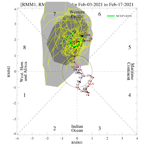
Now take a look at next Weds on the 12z GEFS. I cherry picked this frame(there aren't many warm ones after Sunday). It is Tuesday, and that is phase 7 nearly perfectly. Go to Tropical Tidbits and see where it goes after that.
-
Everyone, take a look at phase 7....Now, take a look at what next week is trending towards. The MJO is driving the bus in short term modeling. Since the US modeling is winning some battles right now(no surprise...Euro is again mortal during shoulder season). The EMON looks nearly identical, but actually goes into 8. This is why I think medium and LR modeling may well be right on the potential for severe cold. As for skepticism, people who are scientists should take it in healthy doses every day. I am a natural skeptic. The best problem solving teams always need people who say, "Wait a minute, have you thought about this?" Group think is bad mojo in my book.
-
I don't think extreme cold is off the table. Of course nothing to do with weather and climate forecasting is a certainty. Now that modeling is working out the details with the weekend nada storm, seems to be getting a better handle on when the cold will arrive. I will say this (and it is no certainty), but if we go MJO phase 8, have a -NAO, and have incredibly cold air in NA...that cold is likely coming into the SE. If we like the idea that the Euro caved to US modeling this weekend, it is worth noting that the US MJO was very aggressive in racing across phase 7. I am not sure if it is right, but it is worth noting. Honestly, kind of exciting seeing that type of cold on a map.
-
What is the knock on the UK...feel like I have missed something? UK is always really amped. Bout the only thing I have used it for (other than cold yesterday) is to see if it gives me a clue to the Euro run.
-
Will be interesting to see how this plays out. Both the CMC and GFS have extreme AN high pressure just after d8 dropping into the Canadian prairie and Montana. That is syncs nicely with the MJO looks from the morning.
-
Just looking at NCEP MJO stuff this AM...definite trend to head towards phase 8. Many of the OLR maps also show this. I noted yesterday that I wasn't overly enthused with the MJO as most models had it stalled in phases 6-7 which are warm. Let's see if modeling doesn't react to that trend today. If anything modeling may have gotten ahead of itself yesterday. That said, if the trend to move towards 8 is legit, then I think we are in business. Right now phase 6/7 is going to fight everything. (NAO has saved us from the torch all winter and has been a key driver this winter). For several days it seemed the MJO plot and actual modeled OLR maps were out of sync - meaning OLR looked like phase 8 but the plot was not. And again, this really seems like the '89/90 analog merged with the '95/96 analog. I think we just need to be ready for some wild swings in modeling coming up.
-
It may have been. Have you seen where it was upgraded?
-
Just now digging through ensembles this morning, I don't see a ton of major changes to the pattern overall. If there is one trend it is to shave off the cold on the SE end of the are of BN heights which extend from the Mountain West deep into the SE. We will watch trends today. Again, the 6z GFS has the cold back on its run, though about 72 hours later. Dig through my comments yesterday, and I said rthat the MJO phase 6/7 was going to fight the cold. That is a very warm MJO signal. You can see the SER try to pop but get knocked down by the cold. Occurs at least a couple of times on the Euro run. What we do have in play now is very cold air at times making intrusions into the Lower 48. I still think the potential for severe cold into our area is very real. I just think modeling is trying to get the timing of each system down, and as Holston noted, modeling really struggles when cold air is on the playing field. As for storms, systems that run the gradient are tricky. But I will say if you want big snow, you really have to be willing to be right on the edge where the freezing line is. Again the 6z GFS is probably the coldest run that I have seen for my area in many years. Going to be plenty of fluctuations. if we get any snow on the ground before the cold moves in, that is going to be some seriously cold air sliding in along the snow pack.
-
Going to make a correction...the 6z GFS does indeed have record cold back on that model. It is in the d7-10 timeframe but looks remarkably like the Euro yesterday. Temps overnight in my area on d10 are -8F to -13F. There is very nearly some -20 stuff in SW VA.
-
Thing to remember about the UKMET, it has a tendency to oversimplify in the mid-range. Just have to take into account that bias.
-
I just use the UKMET on Pivotal.
-
Good point. Any time there is severe cold on modeling, things can go haywire in a NY minute. Will be interesting to see where this all goes during the next 72 hours.
-
The problem is that the Sunday system is just missing a phase...literally by hours. That could change. Interesting find on the UKMET. Did it have anything yesterday? Thought I remembered a whiff on Pivotal?
-
Thoughts on Sunday are still generally the same. If we assume the 6z GFS(not the para) is East of where it will verify AND the northern stream stays with the same speed, I think that will be a bigger storm. Should know by tomorrow morning what that trend is(meaning does it trend back towards a phase?). Seriously though, if that thing phases it could cut well west of current solutions. Again, pretty much out of runway by mid-day tomorrow on that system. I would think if it trends back towards a storm, that would begin to trend that way today.
-
Yep, it is a day old. Give me a sec to amend my comments above. Saw 6z and assumed it was legit.
-
Man, hope I am not looking at an old run...let me check.
-
May be running out of runway for the Sunday system. I think the trend is OTS with no phase, but going to watch modeling today to see what happens. Likely is nothing, but not sleeping on it either. The 6z GFS and 6z ICON are not completely benign. The cold is less severe (speaking in generalities) on modeling this AM, and that includes pretty much all of the Lower 48. As John notes, the trough amplification is massive and suppresses everything. We can get suppression without the vodka cold. However, I will note that has been an error all winter on modeling re: the SE. Generally, modeling has over-estimated the depth that cold penetrates into the SE at mid-range. Just take a look at d5-7 now. That front is not going as far south as was originally projected, and allows for rain for a system, which at one point, was snow without a doubt. One of the reasons I really like cold on modeling is that modeling has been modifying it of late. I still think we see cold. Would be somewhat surprised if someone in the subform doesn't see accumulating frozen precip during the two weeks which follow Feb 5th. A
-
Solar has been way, way off. That last cycle was weak(as predicted due to the sun going so quiet around 2010 I think). That definitely coincides with a lack of moderate/strong La Ninas. I always think moderate to strong La Ninas reset the temp gradient in the equatorial Pacific. For those of you who don't know what I am speaking of(I know Tellico does), we are used to weak El Ninos being great winter weather signals. However, for the El Nino to be a strong winter wx signal in the East, the Sea Surface Temps(SSTs) need to be colder in the places which are not part of the El Nino. The stronger that temp differential(the gradient) between the Nino and the rest of the Pacific, the more likely the El Nino behaves as normal. With SSTs above normal in much of the Pac for the past 4-5 years, the Nino climatology was been washed out. I am hoping that this La Nina will allow the next Nino to have a stronger gradient and behave more as a Nino would. As Tellico notes, all of this is likely tied together. And again, the AMO cycle is only about 2/3 of the way through - maybe it will end early? I do hold out hope that this year's unexpected -NAO cycle this winter might well be a harbinger of better winters to come.
-
Great question. Makes me wonder if the abnormally warm Pacific (due to a decadal trend which features a lack of moderate to strong Ninas balancing surface temps) has created a lack of gradient which is affecting global wind patterns. Just spitballing, but I know Typhoon Tip has talked about ENSO analogs being less effective due to the lack of gradient. Maybe this La Nina will add some balance to the force so to speak.
-
The 12z/18z GEFS and 12z GEPS look decent in the LR regarding the 500 pattern. Thinking back just a few days, that is a pretty big move in the LR.

