

Carvers Gap
-
Posts
17,470 -
Joined
-
Last visited
Content Type
Profiles
Blogs
Forums
American Weather
Media Demo
Store
Gallery
Everything posted by Carvers Gap
-

January 2021 Medium/Longterm Pattern Discussion.
Carvers Gap replied to AMZ8990's topic in Tennessee Valley
@Holston_River_Rambler, have those Euro Weeklies ready to roll? You get the honors. -
January 2021 Medium/Longterm Pattern Discussion.
Carvers Gap replied to AMZ8990's topic in Tennessee Valley
Some of those patterns are not too far from where we are now, especially 09-10. Difference is the cold source. -
January 2021 Medium/Longterm Pattern Discussion.
Carvers Gap replied to AMZ8990's topic in Tennessee Valley
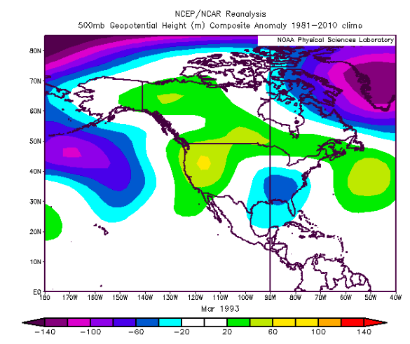
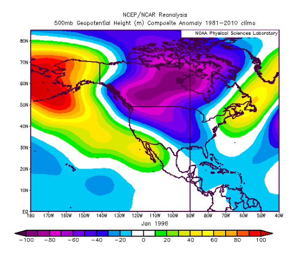
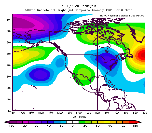
For fun...Here are some historically great 500mb patterns for the TN Valley forum area during winter.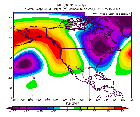
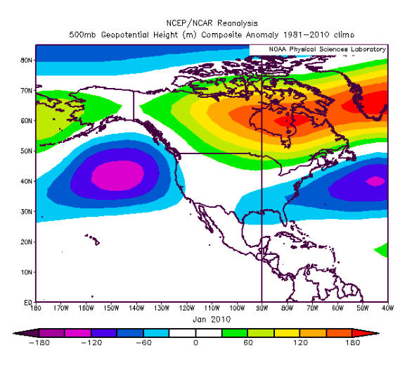
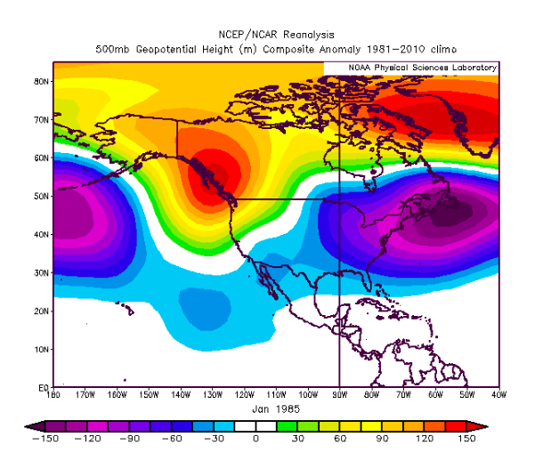
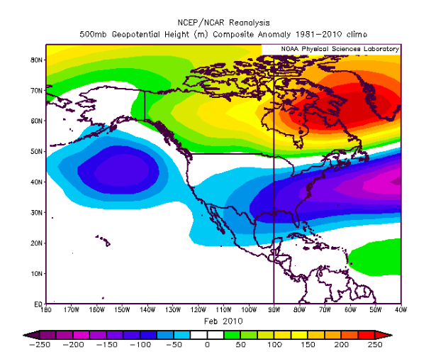
-
January 2021 Medium/Longterm Pattern Discussion.
Carvers Gap replied to AMZ8990's topic in Tennessee Valley
Looks like the d12+ GEFS, EPS, and GEPS now "splits" the western trough, and send part of it eastward. That is a good thing. The 12z EPS looks really good if one takes into account it is likely woefully undergoing the its trough(been a bias for months) underneath those blocks. The improvement since 12z yesterday is the eastern ridge appears temporary(at least for now - modeling is all over the place. I am a huge fan of the -NAO slows down flow and creates excellent confluence. Some great winters have had it. Some years with the Pac being the only dominant block, the flow is too fast. NW flow in Kingsport is also a non-starter as we don't get upslope stuff. A true -NAO (which is not battling the Pacific/MJO) is money during winter for east facing slopes. NE TN can get snow from an Atlantic fetch which is common during -NAO phase storms - TYS as well. The Christmas Eve Storm benefited from a PNA and the NAO both. Without the NAO, that storm likely cuts. Problem with the NAO right now...it is on its own and no cold source. If that NAO had Siberian cold to draw from...would be money - even if on its own. Our biggest problem regardless of the Pac or Atlantic blocking is that the cold is in Siberia. Saw Siberia nearly set an all-time record HP - think it was 1076 if the twee was correct. We need some of that here. I have my doubts that we get Canada seeded with cold anytime soon. Our cold will have to be homegrown. -
January 2021 Medium/Longterm Pattern Discussion.
Carvers Gap replied to AMZ8990's topic in Tennessee Valley
Para-GFS on Pivotal is pretty much there. -
January 2021 Medium/Longterm Pattern Discussion.
Carvers Gap replied to AMZ8990's topic in Tennessee Valley
They are feeling the disruption now for sure. If the SSW can simply jostle the TPV and keep it perturbed, that would be the best scenario(as long as it doesn't tighten up). Seeing some disruption to yesterday's second week of Jan modeling. Guessing the Euro is slow with that trough. GFS Para also has the Jan 3/4 storm. Just read a post by Cosgrove that said each trough is going to press the eastern ridge further east(once it forms) - meaning trough comes through, ridge resets a bit further eastward, wash-rinse-repeat until it slides OTS. Trends on modeling during the next couple of days should be interesting(could be good, could be bad). The CFSv2 seasonal is back to a trough in the East for January. -
January 2021 Medium/Longterm Pattern Discussion.
Carvers Gap replied to AMZ8990's topic in Tennessee Valley
And modeling is having a rough time in the short term. Check out this westward jog(forecast Trent) for the system that was forecast to snow for E TN at one point. -
January 2021 Medium/Longterm Pattern Discussion.
Carvers Gap replied to AMZ8990's topic in Tennessee Valley
Just digging through the MJO this morning...lots of options on modeling. Most of those options deal with the right hand side of the MJO phase diagram. Generally speaking, there is a trend to go into phase 2 which is colder and then propagate around the to 4. The GEFS is very aggressive with this and only the hi-res goes into 2. They ECMWF goes 2/3 then COD. Phase 2 is colder. Phase 3 gets colder the further one gets into January. Phase 4 is warm. Seems like only the GEFS is wanting to gain amplitude with its MJO forecast, and its OLR map is curtly more aggressive than say the CA. -
January 2021 Medium/Longterm Pattern Discussion.
Carvers Gap replied to AMZ8990's topic in Tennessee Valley
Big thing for the LR forecasts is to see that trough in the East moving forward in time mid mont. GEFS is definitely the better of the 3. It is worth mentioning that the GEFS did really well with the Feb '18 strat split. That said, if we steal a storm shortly after Jan1(before the warm-up), that would be big. Something to watch. -
January 2021 Medium/Longterm Pattern Discussion.
Carvers Gap replied to AMZ8990's topic in Tennessee Valley
The 6z GFS and 0z CMC also have it to varying degrees. -
January 2021 Medium/Longterm Pattern Discussion.
Carvers Gap replied to AMZ8990's topic in Tennessee Valley
Sneaky system on the Euro operational at 156. The GFS has had this off and on. -
January 2021 Medium/Longterm Pattern Discussion.
Carvers Gap replied to AMZ8990's topic in Tennessee Valley
Yeah, I think the first two weeks of January just after the New year(barring a thread the needle situation) have flipped warm. That said(and I really even hate saying this, because if I had a nickel...) in about 14 days, the 18z GEFS is showing a workable pattern. Trends have been pretty good this afternoon. Need to see those moving forward in time and increasing in relevance as they get closer...I can't do the backend winter deal from the past two years where we waited, and waited, and waited. This could be a pattern change or just a relaxation of the pattern from December. I simply don't know. This morning I would have said pattern change...now maybe more like a pattern relaxation. Some great SSW posts this morning - that event will have a big say so going forward. Lots of uncertainty from mid-January onward. The MJO is going to fight anything good for the East. The -NAO should win from time-to-time. However, not having cold in Canada is a major problem. Like a broken record, I say this every year. Some truly great winters never got going until mid-January. However, Nina climatology will very likely make sure the Mountain West scores this winter. -
January 2021 Medium/Longterm Pattern Discussion.
Carvers Gap replied to AMZ8990's topic in Tennessee Valley
Just spitballing....One thought I had this morning is that we are long overdue for a stretch of winters with -NAO/Atlantic blocking. If we could hit such a stretch, that gives us many more scenarios towards better winters and could offset MJO problems. The Pacific is defiantly a more consistent driver for cold when it is favorable. However, the Atlantic is saving our tails this winter. I fully believe this winter would have been very warm had the NAO not flipped negative unexpectedly. The NAO deal is likey tied to the AMO being in a warm phase for us...but maybe this(a stretch of NAO winters) is kind of a run-op or a cue that it is about to flip during the upcoming years. -
January 2021 Medium/Longterm Pattern Discussion.
Carvers Gap replied to AMZ8990's topic in Tennessee Valley
Also, for TRI folks...I noticed that MRX is mentioning patching freezing drizzle in the AM. Just a heads up. -
January 2021 Medium/Longterm Pattern Discussion.
Carvers Gap replied to AMZ8990's topic in Tennessee Valley
I think we are going to be fighting the MJO the rest of the way - very much agree. Hoping this strat split and high latitude blocking will provide some balance this year. I liked where the 18z GEFS went. Really hope that holds. -
January 2021 Medium/Longterm Pattern Discussion.
Carvers Gap replied to AMZ8990's topic in Tennessee Valley
@Holston_River_Rambler, the 18z GEFS and GFS support your idea that we are going to see cold. The 18z CFSv2 does as well. The GEFS extended is meh, but it ran on an earlier run today I think. So, trends this afternoon have been quickly to a more favorable solution. Maybe those ensembles are "feeling" the strat split now? You may be on to something. -
January 2021 Medium/Longterm Pattern Discussion.
Carvers Gap replied to AMZ8990's topic in Tennessee Valley
I wouldn't give up on your cold shot just yet. A little help from the PAC, and things would get interesting just after the 12z EPS run. The thing to watch now is how the EPS corrects now that it wants a trough in the East late in its run. Won't take much to take the d10-15 look on the EPS and make it better...and won't take much to make it worse. LOL. What is the phrase from last week? Living on the edge! This is your cold shot if it happens! Again, I like 09-10 and 18-19 as SSW events. 09-10 Turned out pretty well I think. Having that -NAO and -AO up there is to our benefit with the SSW. -
January 2021 Medium/Longterm Pattern Discussion.
Carvers Gap replied to AMZ8990's topic in Tennessee Valley
Basically the NAO connects or extends into a ridge that stretches from lower latitudes into the Arctic. Normally, that is something one sees during the summer. As Boone noted, that is a fairly fair feature during winter. It is likely the mechanism that will split the TPV. When I see it during SSWs, I always think "torch." But you can almost take it to the bank the an SSW is under way (or about to be when you see the monster). -
January 2021 Medium/Longterm Pattern Discussion.
Carvers Gap replied to AMZ8990's topic in Tennessee Valley
12z Euro - Western Atlantic Ridge City. -
January 2021 Medium/Longterm Pattern Discussion.
Carvers Gap replied to AMZ8990's topic in Tennessee Valley
Cause you know like clockwork, the 12z GFS is going to go stone cold after I make a post about a warm-up - at least it is sort of in the time frame that was discussed. LOL. I actually don't mind unpredictability. I just don't like warm patterns which lock into place. -
January 2021 Medium/Longterm Pattern Discussion.
Carvers Gap replied to AMZ8990's topic in Tennessee Valley
The 2019 split was right around the development of an El Nino. It seems that El Nino failed to couple immediately with the atmosphere IMO as evidenced by the Nina-eque conditions that would be had the following winter - which was last winter. IMHO, we finally had Nino conditions from that event just this past summer and those lasted into December of this year despite the Nina. So, that 2019 event might be a decent counterbalance to the Feb'10 event - those would be my two choices and they give a wide range of "good" and "bad" outcomes. -
January 2021 Medium/Longterm Pattern Discussion.
Carvers Gap replied to AMZ8990's topic in Tennessee Valley
Here is the paper on the SSW for January 2019. Dig through it. I can barley understand about half of it. However, one can see the split in early January of at least one of the vortices into twin vortices. Have to go running. I have not read all of it. Will be chewing on that for a while. Seems to me there are similarities in both the Feb'10 and Jan'19 events. Looks like the 2019 did indeed split the 2019 SPV. http://s2sprediction.net/file/documents_publications/2019JD030826.pdf -
January 2021 Medium/Longterm Pattern Discussion.
Carvers Gap replied to AMZ8990's topic in Tennessee Valley
January 2019 would be the other (glass half empty) SSW. I "think" both of those winters had some La Nina characteristics(both Feb10, and Jan19). 2019 did have an SSW event - debatable what it did to the TPV. I did go back and check this morning on the site below about 2019. That was the January that had a great look and went to pot due to the SSW(maybe partial or mostly unsuccessful split...think that split had small twin vortices at the TPV off the top of my head but the main vortex held) https://csl.noaa.gov/groups/csl8/sswcompendium/ -
January 2021 Medium/Longterm Pattern Discussion.
Carvers Gap replied to AMZ8990's topic in Tennessee Valley
Interesting stuff, Holston. January 1985 in terms of cold is what March 1993 is in terms of storms for NE TN. It is the Holy Grail of winter patterns. I think right now this is a very different era in terms of weather. Not sure the usual analogs apply - and that could be good or bad. We will see. Certainly not going to complain if the weather goes that direction. Will be tough to reverse the temps AN anomalies for the first two weeks of January I think. The one possible good scenario which I mentioned a few days ago(and this AM), is that if the cold were to dump into that trough forecast mid-month, that would be a well-timed strat split. SSWs in my experience are just terribly tough to predict. Truly hate that we are substituting what looked like a decent pattern for a flat unknown(leaning warm) pattern. "IF" this is going to be in our favor, we should begin to see that on modeling quite soon. The past couple of SSWs have resulted in cold dumping into the Rockies after a head fake eastward. Second half of the month of January would be our chance. My bigger concern is there is very little cold on this side of the hemisphere to even tap should the SSW behave favorably - takes some time to resupply Canada. I do think we are likely at least one more cold shot that would be a good winter storm window, even if the pattern flips to a western trough. Very much looks like the West is about to get winter after a quiet month in December which followed a great November there. @Holston_River_Rambler, see what you think about February 2010. If I was going with a glass half full attitude, that would be my choice in terms of similarities. Very similar in terms of set-up - even had a late December snow in NE TN. -
January 2021 Medium/Longterm Pattern Discussion.
Carvers Gap replied to AMZ8990's topic in Tennessee Valley
A warm to very warm pattern is beginning to show up in the medium to long range ensembles, and beginning by midweek of this week. The 12z EPS has moved the eastern ridge flip to this Tuesday w one slp passing through it afterwards. The eastern ridge will likely get stronger during the next 7-10 days. This is the time of year when the EPS begins to rule the roost, but is not infallible either. It does provide some relief around d14 with a ridge redeveloping out West. We saw a similar look last year. As with this last year, the cold air supply will be likely lacking. My confidence is increasing that we are about to enter at least a two week time from from from say Dec30-Jan15 of AN to much AN temps w a seasonal day or two thrown in. After that, comes the game we have played for the last two winters....waiting for the pattern to come back. Is this trough out West a pattern relaxation or a new pattern. Don't know, but I do know that trough has been tough to move (during the past two winters) once in place regardless of EPO ridges(tucks under that ridge) and SSW events. The -NAO looks to be a consistent feature, but connects with the eastern ridge. There are signs this current pattern could return during the second half of January, but if I had a dime for every time I said that during the past two years, I would be a wealthy man. The MJO this morning is now forecast to go into phase three and likely four(with a warm tour likely), and I wouldn't be surprised to see it loop back through those phases once finished...the OLR maps show very little movement from the phase 3-4 regions. The MJO is now driving the bus, though the -NAO does sit in the passenger seat. I think the greater concern is that NA is going to be completely devoid of cold air for the foreseeable future. Now, it can still snow in a warm pattern, but is much more difficult. This year would be a possibility for exactly that with the -NAO in place and storms tracking south. The wild card which I hate to depend upon for cold weather is the strat warm. Yet again, it has fouled what looked like was a nice pattern on the horizon in modeling. Right now we are either looking at a potential pattern change to an eastern ridge/western trough or a long relaxation of the December pattern which was decent(not exceptional but decent). During the next 2-3 days, if we are still looking at the western ridge holding in the d14-16 range on the EPS, then we know the drill. So, hopefully (and I have low expectations for this)...we see the western ridge pop mid-month and the -NAO holds(there is some evidence in LR modeling that it may be leaving the playing field later in January according to the 6z CFSv2 run) - if so that is cold pattern IF cold air can be supplied to NA. (The once strongly forecast -NAO for the end of this month - it is positive today on the CPC site.). Maybe we can steal a storm in a warm pattern coming up. Last note, when the SSW hit in 2018, modeling flipped from warm to cold in one, single run for March. I am not holding my breath on that one, but that is on the table as an option. For now the SSW looks to impact East Asia and Western Europe. That could change. So January thaw or pattern change? That is the real question for me.


