

jm1220
-
Posts
26,187 -
Joined
-
Last visited
Content Type
Profiles
Blogs
Forums
American Weather
Media Demo
Store
Gallery
Everything posted by jm1220
-
Might be hazy tomorrow-HRRR shows another smoke plume coming east behind the front.
-
The lawns are green at least. Nothing worse than staring at endless brown dead grass.
-
Misty misery Monday.
-
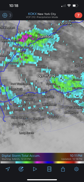
From RadarScope. Darker gray is 0.5-1”, Blue is roughly 1”+, green is 1.5”+. The purple dots are 2”.
-
Looks like about 1.2-1.4” here. A few 2” pixels SW of me.
-
Radar estimating almost 2” near West Hills.
-
Dumping here.
-
I'm sick today anyway with the bug that's been spreading around my office. So whatever. Light steady rain here which is what it looks like we'll have for the next hour or so.
-
Hopefully. My car could use a wash anyway.
-
I think the rainy conditions to our west and the tendency once again of over-the-top heat and steep ridge patterns means our summer will probably be humid and hot but not excessively so. We'll hit 95 a few times but outside of Newark once or twice maybe no 100s. With the steep ridge we can't get the warming downslope westerly flow and instead drown in FL-like humidity with S flow. And that means the coast likely goes into summer drought mode stuck in the marine layer while inland gets the T-storms unless we can get a more organized system to drive them to the coast. I'm glad we all had the rainy May so we can stock up before it inevitably dries out for summer. We might already be starting it on the modeling which shows heavy rain inland and relatively dry NYC east.
-
Heat drives the weather, oceans store enormous amounts of heat and the western Pacific is currently where that stored heat is greatest in our largest ocean basin, so it drives the weather patterns. We may be in a long term -PDO cycle but I’m pretty confident CC is driving it to some degree. Someone who studies this more closely can definitely elaborate more.
-
Barrier islands in the mid 60s. Might be about as warm as they get since as the day goes on the seabreeze only strengthens.
-
I’m happy we had the wet May. Bank what we can before we inevitably start drying out during summer. That might be starting-models don’t have much here for the next 10 days.
-
NWS has 88 here for the high, perhaps first 90 if the seabreeze isn’t too strong early on. Beaches probably won’t make it much over 70.
-
Seems like highs were around 70-71 on the barrier islands, was 81-82 at my house. I’ve seen much bigger gradients this time of year-20 degrees or more.
-
Seabreeze just getting here, pronounced on radar. Was hung up by the LIE for a while. Temp 80.
-
Ugh. As we all know once droopy cutoff low season starts it can be impossible to get rid of.
-
All the wet weather/flooding to our west and south might work against big ridging there again this summer which would mean more southerly flow/humid FL type weather vs westerly flow drier heat that can give many of us a chance at 100.
-
We don’t have a “bread and butter” snow pattern here. We can score in just about every snowstorm setup but also get totally screwed if one part goes awry. Big Miller A moisture bombs common in El Niño are DC’s bread and butter. It gave us our biggest snowstorm ever in Jan 2016 but we also got zilch in the 2/6/10 storm by 20 miles. Miller B late bloomers are Boston’s bread and butter-they can hammer NYC if they form soon enough or the city gets zilch. That’s why NYC is by far the hardest city to forecast for in the winter in a snowstorm setup-small changes mean hammered or cirrus or rain/sleet for a big chunk like in 2/8/13. Lake cutters and SWFEs I assume are yours that are guaranteed for at least something decent 4-5 days out. Those 90% of the time here are cold rain. Marginal setups more and more are cold rain in the city, and the 3-6” type cold clippers have gone extinct.
-
We want pretty much diametrically opposite patterns in the winter, although we have some like 2010-11 where we both do well. I think the final snow number comes from the fact that here, we usually get all or nothing type seasons and big individual storms rather than smaller nickel and dimes that can still get to 40+ inches on the season. And sustained cold is quite rare at least the last 10-15 years. Generally you want more of these Nina type setups since they favor the Lakes while I desperately want it to become more El Niño like. Whatever can make this wretchedness since Jan 2022 end I’m all for.
-
He isn’t saying NYC will never have a good winter again unless we have another Pinatubo or Yellowstone blows up (in which case we have more serious problems lol). We had a pretty good one in 2020-21. But we’re definitely in a steep downturn overall and it’s fairly easy to see why-it’s being ruined largely by the W Pacific on steroids. To me there’s not much if/but or deep analysis needed and it makes a lot of sense as much as I hate it. Reality doesn’t care. We see time after time decent setups literally blown/sheared apart by the fast Pacific jet or the ridge/trough orientation pushed too far east, or the SE ridge takes over and we get lousy cutters/SWFE that can be great for I-90 and the Lakes but horrendous here. You can just see how it keeps evolving. Until that base state changes where we’re in either a defined Nina or quasi-Nina with the warm W Pacific which cancels out even strong El Niño, I don’t see how our outcomes change. There can be a winter like 2020-21 every once in a blue moon in this state where other factors can overcome it but it will be the exception.
-
2 weekends in a row ruined for good beach weather now. Can’t get it much over 70 on the shore before either clouds/rain or the 40mph Ambrose Jet. There are days where that wind approaches 50mph.
-
Some instability showers later so we’re not totally done.
-
The 500mb low closed off in the right spot. The front end was ruined because the storm hugged the coast, but the closed off low kicked the low east and wrapped moisture around to the west to create the backlash heavy snow band.
-
It was clear the last 48 hours this storm would favor N NJ and Hudson Valley. It's not some surprise at least not to me.


