Met1985
-
Posts
16,564 -
Joined
-
Last visited
Content Type
Profiles
Blogs
Forums
American Weather
Media Demo
Store
Gallery
Everything posted by Met1985
-

2025 Spring/Summer Mountain Thread
Met1985 replied to Maggie Valley Steve's topic in Southeastern States
A stellar morning this morning. Clear with a low of 49 degrees on June 11th. Cannot beat that for this time of the year. Yesterday had a high of 73. -
2025 Spring/Summer Mountain Thread
Met1985 replied to Maggie Valley Steve's topic in Southeastern States
Going to be a booming weekend! -
2025 Spring/Summer Mountain Thread
Met1985 replied to Maggie Valley Steve's topic in Southeastern States
Temp down to already cold 48 degrees already. Freaking love it! -
2025 Spring/Summer Mountain Thread
Met1985 replied to Maggie Valley Steve's topic in Southeastern States
That's what the heck im talking about! Spring can suck it! -
2025 Spring/Summer Mountain Thread
Met1985 replied to Maggie Valley Steve's topic in Southeastern States
Just got home and the wind is blowing 90 out of the north and the temps dropped down to 53. Saw that it's 45 degrees on Mt Mitchell this evening. Absolutely raw. Love it! -
2025 Spring/Summer Mountain Thread
Met1985 replied to Maggie Valley Steve's topic in Southeastern States
Heavy rain and storms moving through again this evening. Temps have dropped from mid 60s to mid 50s now. -
I honestly can't remember when we've had several days here in May with highs only in the 50s. This weather has been fantastic.
-
2025 Spring/Summer Mountain Thread
Met1985 replied to Maggie Valley Steve's topic in Southeastern States
Looks like more rain today and some severe weather possible tomorrow with another strong front. Pretty rare for basically the first of June. -
2025 Spring/Summer Mountain Thread
Met1985 replied to Maggie Valley Steve's topic in Southeastern States
Had a high of only 56 degrees today! Incredible. -
2025 Spring/Summer Mountain Thread
Met1985 replied to Maggie Valley Steve's topic in Southeastern States
Temp down to 55 already. Tomorrow is going to be dang cold for the end of May. Rain from here on out. -
The heck with last summer. That was brutal! Summer basically from April to November. The heck with that! I hope we stay in this persistent trough for a good bit. I'm worried about more Forest fires once we dry out again really and I don't want to have a California fire season.
-
2025 Spring/Summer Mountain Thread
Met1985 replied to Maggie Valley Steve's topic in Southeastern States
I just missed getting to in the 30s with a cold crisp low of 40 degrees. -
2025 Spring/Summer Mountain Thread
Met1985 replied to Maggie Valley Steve's topic in Southeastern States
Yep was an absolute banger of a day! Chilly this morning with a stiff breeze all day. Had a high of 61 on clear blue skies on May 23rd! Freaking amazing. Going to make a run at the upper 30s tonight. -
2025 Spring/Summer Mountain Thread
Met1985 replied to Maggie Valley Steve's topic in Southeastern States
Wind stayed blowing all night here. Temp only down to 47 but feels great. -
2025 Spring/Summer Mountain Thread
Met1985 replied to Maggie Valley Steve's topic in Southeastern States
Yes this afternoon and evening we're very windy. Reminded me of a cold from blowing in here around February. Temp is nippy also with 57 degrees and dropping. -
2025 Spring/Summer Mountain Thread
Met1985 replied to Maggie Valley Steve's topic in Southeastern States
Yeah the wind has really picked up here this afternoon in Hendersonville. -
2025 Spring/Summer Mountain Thread
Met1985 replied to Maggie Valley Steve's topic in Southeastern States
Some could see 30s Saturday morning. -
2025 Spring/Summer Mountain Thread
Met1985 replied to Maggie Valley Steve's topic in Southeastern States
Tornado watch will be hoisted up this evening for WNC per Jason Boyer. -
2025 Spring/Summer Mountain Thread
Met1985 replied to Maggie Valley Steve's topic in Southeastern States
Severe storms tonight. Sent from my SM-G998U using Tapatalk
-
2025 Spring/Summer Mountain Thread
Met1985 replied to Maggie Valley Steve's topic in Southeastern States
Ill take this anytime during late May. A stark contrasts from last year and very refreshing. Sent from my SM-G998U using Tapatalk
.thumb.jpg.492a7d57e0809e0c779cb52e20f08f8f.jpg)
.thumb.jpg.45233150a12cedcc6257cc3c9c0ebeda.jpg)
.thumb.jpg.c2b550856fcddffd0aaa63f97eff509e.jpg)
-
2025 Spring/Summer Mountain Thread
Met1985 replied to Maggie Valley Steve's topic in Southeastern States
Big time storms rolling in hard. -
2025 Spring/Summer Mountain Thread
Met1985 replied to Maggie Valley Steve's topic in Southeastern States
Severe Thunderstorm Warning for... McDowell County in western North Carolina... Southeastern Mitchell County in western North Carolina... Southwestern Avery County in western North Carolina... Buncombe County in western North Carolina... Central Haywood County in western North Carolina... Southeastern Yancey County in western North Carolina... Northwestern Burke County in western North Carolina... * Until 430 AM EDT. * At 341 AM EDT, severe thunderstorms were located along a line extending from 5 miles northeast of Burnsville to 13 miles northeast of Downtown Asheville to 8 miles north of Waynesville, moving southeast at 45 mph. HAZARD...60 mph wind gusts and nickel size hail. SOURCE...Radar indicated. IMPACT...Expect damage to trees and power lines. * Locations impacted include... Ingalls, East Asheville, Ashford, Linville Falls, West Asheville, Swannanoa, North Cove, Celo, Little Switzerland, and Warren Wilson College. -
2025 Spring/Summer Mountain Thread
Met1985 replied to Maggie Valley Steve's topic in Southeastern States
Love this. -
2025 Spring/Summer Mountain Thread
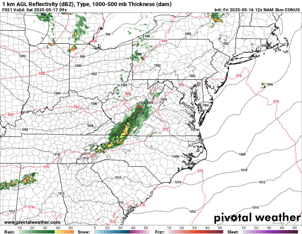
Met1985 replied to Maggie Valley Steve's topic in Southeastern States
So basically all the 12z models have this line as pretty lame and as soon as it hits the mountains it just falls apart. Sent from my SM-G998U using Tapatalk
-
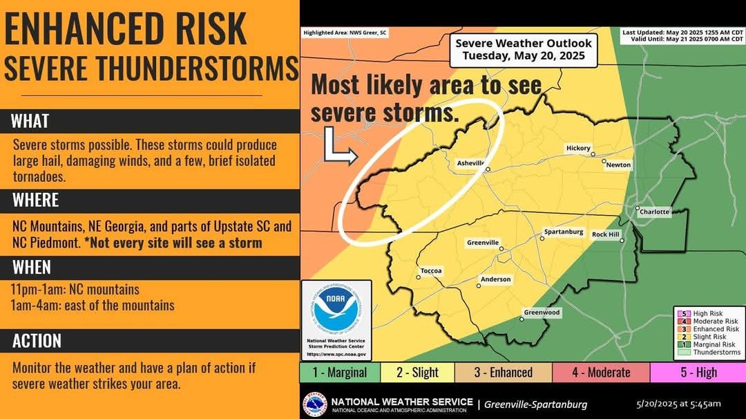
2025 Spring/Summer Mountain Thread
Met1985 replied to Maggie Valley Steve's topic in Southeastern States
NWS time line for storms tonight. Sent from my SM-G998U using Tapatalk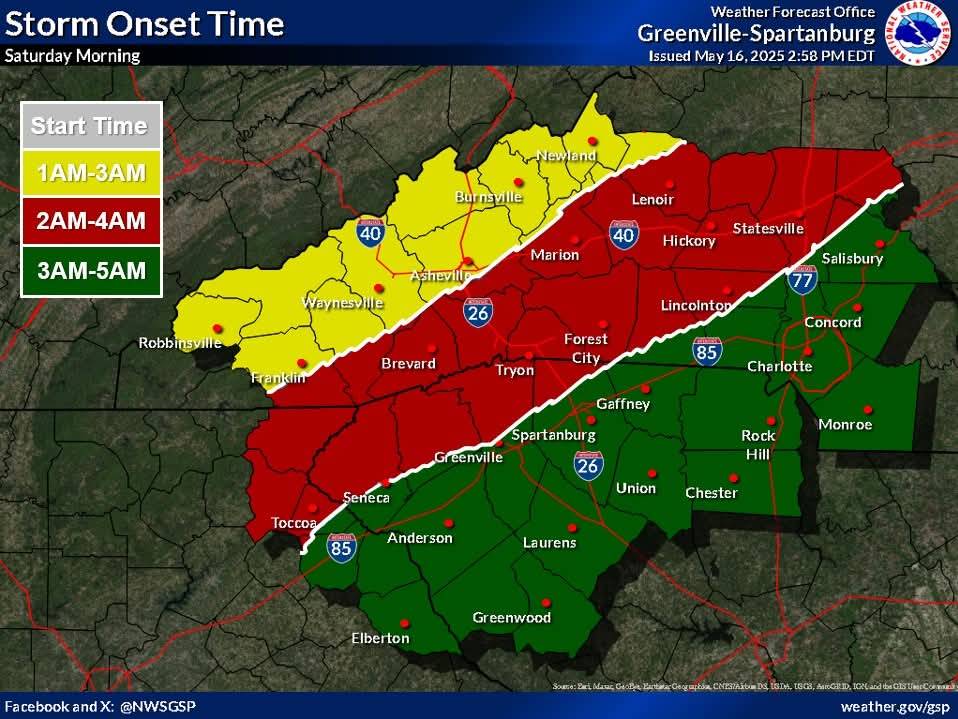


.jpg.b3ae474816684c71f91438d5d907c084.jpg)
.jpg.ece1fa0b96e8a2b89f2a677a42cfe3e4.jpg)

.jpg.ba840e742d9eb6a97a7680639e3bf6e1.jpg)