

Met1985
-
Posts
16,909 -
Joined
-
Last visited
Content Type
Profiles
Blogs
Forums
American Weather
Media Demo
Store
Gallery
Everything posted by Met1985
-
The way the models have been adjusting especially with this upcoming cold shot because of the building negative NAO there will be some wild swings especially in the mid range.
-
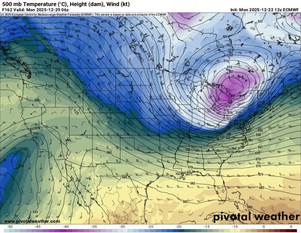
Not a terrible look from the Euro. Sent from my SM-G998U using Tapatalk

.thumb.jpg.8203498f115adbdcd7c53700bae630b3.jpg)
.thumb.jpg.a024d1c9211fd60991c546593c6ec1d4.jpg)
-
Yup. Lol ill be here all day.
-
The pattern has been showing up being volatile especially this past week. Things have become more clear this weekend especially the recent runs of both the gfs and the EURO. We will agree to disagree. We don't see eye to eye on multiple things anyways.
-
This would be a nice blast of cold after this week. Sent from my SM-G998U using Tapatalk
.thumb.jpg.96ae8f8b31ea508162338bd294302d1a.jpg)
-
I think they have been when trying to extend a warm spell. We've seen them wrong several times this season just as Larry pointed out about the EPS.
-
Im giving you my opinion in the way the models have performed in the long range this season. Honestly we could look decent, torch, or in the freezer. We are just seeing a lot of volatility in the models.
-
I disagree. This is just too far out there with the way the models have been performing this season for the most part.
-
Obviously not. We had a warm period before Thanksgiving. We thought we'd torch right through Thanksgiving but no we had a very cold end to November and a cold start to December. We've been well below average for the better part of 3 weeks. So yes we've seen this several times across the board where yes the operational models and the ensembles have performed very poorly in the middle and long range multiple times this season.
-
We've seen this all season long just about.
-
23 this morning. The sky was falling this weekend but it's stopped I think.
-
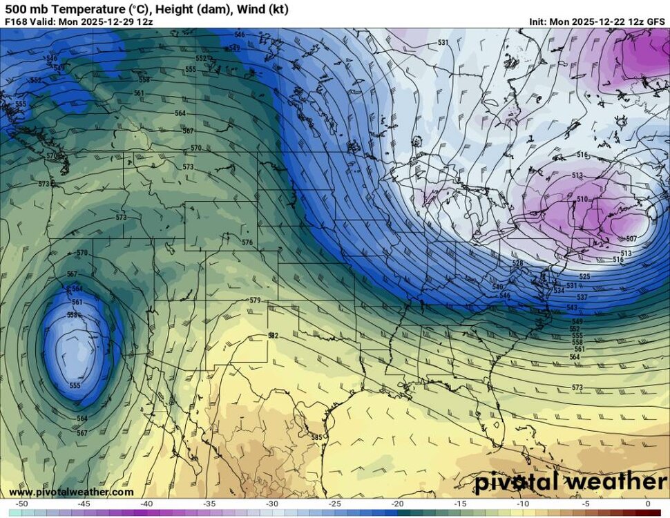
If this trough verifies coming up that would mean non of the ensembles caught this outside day 7. Then the pattern again looks to be up and down. Sent from my SM-G998U using Tapatalk

.thumb.jpg.03c7278e0ca31ebf13722caf83d4fc1f.jpg)
.thumb.jpg.ac96754aa1c52667bd690f2f248b4665.jpg)
-
Probably a record this Christmas as well. We've had several extremes around the south the past couple of years.
-
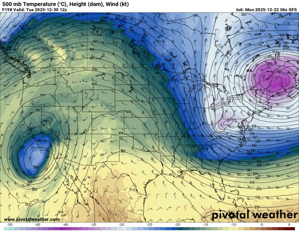
The 12z gfs rolls the trough up top with a backdoor front but amplifies a ridge out west. Yes this coming week is warm but the pattern does jumble up a bit after that. Sent from my SM-G998U using Tapatalk
.thumb.jpg.fe2522063f9dece35c2590da9e5ba697.jpg)
.thumb.jpg.7f204dbef3489b27ac4f06531554f4c3.jpg)
.thumb.jpg.1ca93061372cf59f4c667cc060955385.jpg)
-
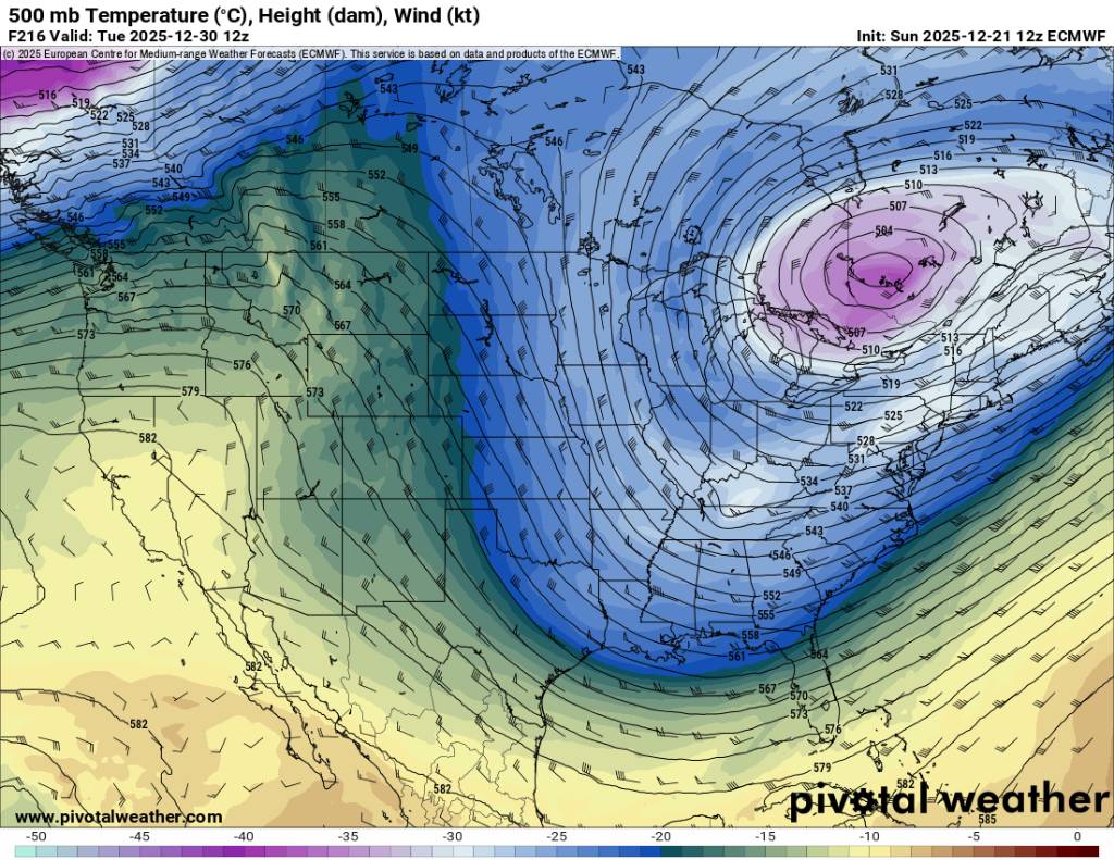
An impressive trough then yes warm-up but then possibly more cold but honestly past day 5 it's a crapshoot. Sent from my SM-G998U using Tapatalk

.thumb.jpg.b851f8c9676223b7938aa39a9a93ee7a.jpg)
-
Well looking forward to severe weather this spring. At least yall already know this winter is cooked. No need to look off the side of the cliff. Just jump and enjoy the warm winter.
-
Some of yall on here actually like we just didn't go through an impressive 3 week cold and some snow stretch. It's comical and im laughing. All you can do. What's the saying. This is the only weather you've got so enjoy it. Something like that.
-
Im calling it. Winter is dead December the 19th.
-
We cooked gang. Looking forward to Spring storms.
-
Taking indicies at face value two weeks out is pretty extreme if I do say. Honestly I'd look for something at the beginning of the new year. The PNA does need to change though. Nice to see Canada in the freezer though. Our cold air source will be there.
-
Yep saw that this evening. Nothing you can do but hope the pattern changes and brings more snow to the area.
-
Yep. I met Thomas with Timm one night. He is a freaking legend and Badger.
-
Temp down to 21 this morning.
-
The NAO and AO look to both be moving into the right direction on the models..the pacific isn't ideal but we can score.
-
It's a crapshoot currently in my opinion.


.jpg.d839f36c74fddeeb14e72361d36fae68.jpg)
.jpg.9b03dedb58b4f719c6dc38cd615b03d8.jpg)

.jpg.c5f4c7eafdd295bac76c2c41c0469a6d.jpg)
.jpg.cca6ffac0c14129b7b0b7fd86096dc52.jpg)
.jpg.24a7fe90864ecd0ebda6c2950c6dece2.jpg)
.jpg.447c9738319fff4f554848b3d83a5d92.jpg)
.jpg.f8231a4692d5360eef40ba0fd0e5b357.jpg)
.jpg.f4015828b1334e7f4a37c5d912137d98.jpg)


.jpg.3a5f6dddb905f3c4018801463d6e0fc9.jpg)


