Met1985
-
Posts
16,909 -
Joined
-
Last visited
Content Type
Profiles
Blogs
Forums
American Weather
Media Demo
Store
Gallery
Everything posted by Met1985
-
Lol this is the truth! The Valley cashes in on synoptic storms but when the freaking low rides the coast like last year it's crap. Us mountain communities are way different from even Buncombe, Hendersonville, and out away from the border.
-
Most of us have seen close to or above average though. Sure we are near the border but it counts as well. Honestly the Asheville airport is in a shitty place. That's literally Fletcher or Mills River in a dang valley. Might as well call that Hendersonville.
-
I definitely get that. I know a lot haven't been as fortunate as some of us in the mountains. Just waiting and watching.
-
Very early in the season. Hopefully the region will score this season.
-
Looks like a nice little event Sunday night into Monday. Hope yall enjoy. I'll be in Charleston this next week.
-
It'll come.
-
Down to 32 with freezing rain currently.
-
Down to 33 and rain.
-
Temp down to 34 no precipitation.
-
36 and like very wet flakes.
-
Temp holding at 37 currently.
-
I know last weekend we did much better with temps running below normal for what they forecast. Earlier this week was about what they predicted so we will see.
-
Models have trended warmer overnight.
-
Cold morning here. 22 degrees.
-
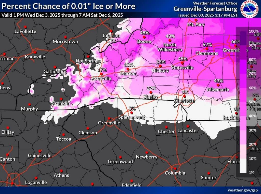
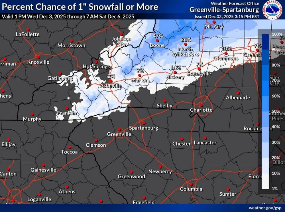
Ashe-Alleghany NC-Watauga-Tazewell-Smyth-Grayson- Including the cities of Independence, Boone, Whitetop, Volney, West Jefferson, Tazewell, Troutdale, Marion, and Sparta 326 AM EST Thu Dec 4 2025 ...WINTER WEATHER ADVISORY IN EFFECT FROM 7 PM THIS EVENING TO 1 PM EST FRIDAY... * WHAT...Wet snow expected. Total snow accumulations between 2 and 4 inches. * WHERE...Portions of the northwest North Carolina High Country and southwest Virginia from Mount Rogers to Tazewell. * WHEN...From 7 PM this evening to 1 PM EST Friday. * IMPACTS...Plan on slippery road conditions. The hazardous conditions are expected to impact the Friday morning commute.
-
Madison-Haywood-Buncombe-Northern Jackson-Southern Jackson- Transylvania- Including the cities of Cashiers and Faust 105 AM EST Thu Dec 4 2025 ...WINTER WEATHER ADVISORY IN EFFECT FROM 7 PM THIS EVENING TO 10 AM EST FRIDAY ABOVE 3500 FEET... * WHAT...Mixed precipitation expected above 3500 feet. Total snow and sleet accumulations up to one half of an inch and ice accumulations around two tenths of an inch. * WHERE...Elevations above 3500ft in Jackson, Haywood, Transylvania, Buncombe, and Madison Counties. * WHEN...From 7 PM this evening to 10 AM EST Friday. * IMPACTS...Snow and ice accumulations will make many roads treacherous and impassable. The weight of the snow and ice on tree limbs and power lines could produce isolated outages. The hazardous conditions could impact the Friday morning commute.
-
Hope yall get hammered! I know this would be a huge win.
-
From the NWS. Sent from my SM-G998U using Tapatalk
-
Hope yall get something decent.
-
Had a low of 23 this morning. Looks like the south central mountains will be all rain this Friday. Looks like hopefully the north central mountains will get snow or a mix. Just looks like the CAD will be too weak for half the mountains which is weird but whatever.
-
26 degrees and flurries. I missed when it was snowing more to cover the deck lightly. Cold out and fire built.
-
Avery-Madison-Yancey-Mitchell-Swain-Haywood- Including the cities of Ingalls, Banner Elk, Newland, Faust, Mars Hill, Marshall, Walnut, Allenstand, Hot Springs, Luck, Swiss, Burnsville, Celo, Micaville, Ramseytown, Busick, Spruce Pine, Poplar, Alarka, Almond, Bryson City, Luada, Wesser, Waynesville, Waterville, Canton, Cruso, and Cove Creek 637 PM EST Tue Dec 2 2025 ...ICY ROADS AND FREEZING FOG POSSIBLE THROUGH WEDNESDAY MORNING... Very light snow should taper off along the North Carolina and Tennessee border tonight. Northwest winds should persist and temperatures are expected to fall into the mid 20s overnight. This is likely to cause a concern for icy road conditions and freezing fog for most of the area, especially at locations above 3500 feet. Use caution if driving and give yourself extra time to commute in the morning.
-
31 degrees and cloudy..definitely going to be a cold one.
-
33 and rain this morning.
-
Down to 38 already but a long way to go before I hit freezing.