

Met1985
-
Posts
16,909 -
Joined
-
Last visited
Content Type
Profiles
Blogs
Forums
American Weather
Media Demo
Store
Gallery
Everything posted by Met1985
-
Yup I called it last week. These systems aren't digging but are sweeping. Good for yall though. Has a nice wintery feel. Got a lot more winter to go.
-
Had a high of 50 with a current temp of 39.
-
Nice man! Send us some pics from out there. Im sure it's absolutely beautiful.
-
Back at home. Current temp of 29 with light snow and a dusting.
-
We have some some amazing photographers in our forum. Some amazing pictures are posted in here.
-
They just canceled for today.
-
Heavy frost with a low I believe of 30 degrees here in North Charleston. Not something you see often down in the low country.
-
Yeah a cold one here in North Charleston. I think today's high was only like 40 degrees and we are currently setting at 30 degrees which is freaking cold for down here. We've had a marine layer here since Sunday with no sun at all.
-
Great freaking picture Tyler!
-
The Mjo will have a say also and most of the mid to long range warm ups haven't really verified this season except a couple. We will see though. Probably have a relaxation then another pattern shuffle.
-
Nice guys! Keep the pictures coming!
-
One heck of an inversion.
-
Was a dang cold morning and frosted to heavy it looks like snow. Low of 20 degrees with was well below the forecast.
-
This looks to be a northern mountain special amd points eastward. Sent from my SM-G998U using Tapatalk

-
That's what I said when I saw it.
-
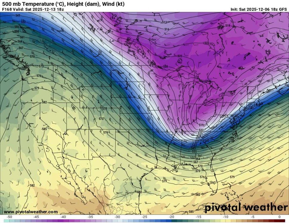
The complexity of not only this month but of the season is an understatement. We have the affects of the SSW from last month. La Nina state is collapsing. Another warming event looks likely this month. The MJO is right where we want it. The SOI and ONI are going to have significant effects down the road.
-
12z Euro on a similar path. Sent from my SM-G998U using Tapatalk
.thumb.jpg.8da3fce72e90220b82cca7242ccbccc2.jpg)
.thumb.jpg.3c484d520d05e4ec0056aba1537fc84b.jpg)
-
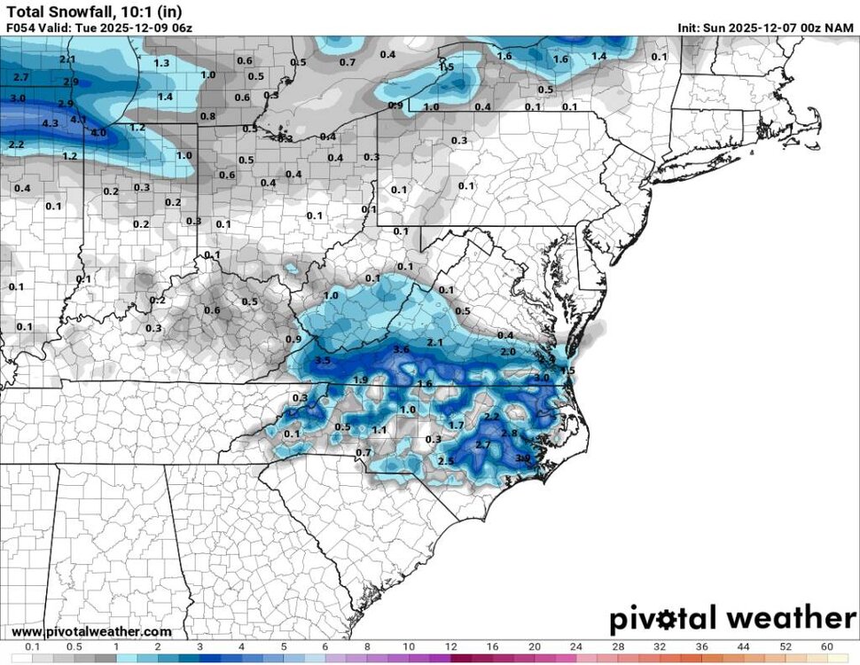
18z gfs bringing down the hammer. Sent from my SM-G998U using Tapatalk
.thumb.jpg.d447ec3facfe677c5a0d32b91eb8f58d.jpg)
-
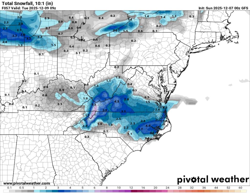
NAM 3K looking good also. Sent from my SM-G998U using Tapatalk
.thumb.jpg.1a32d4297600af732ce05f97016bfdb3.jpg)
-
This map looks odd but is jumping on board for us. Sent from my SM-G998U using Tapatalk
-
29 degrees already tonight.
-
Yup 36 degrees here.
-
Yeah man it does. We get the majority of our seasonal average with upslope snow. Look at @Buckethead annual snowfall. I mean he's high in elevation but he can average like 70 plus and get a foot during a good flow snow event. He'll he probably just about matches Roan mountain. We don't need synoptic along the border bro. We just need great forcing, cold air, and the right wind direction to cash in. I've actually seen where we get a synoptic storm but then we get more flow snow than we do synoptic snow. Flow snow is our bread and butter.
-
I had over 30 inches in Haywood county last year and Steve is very close to that.
-
Honestly I couldn't give two shits about Boone, Asheville, or any other place. I know and several know our local climate and snowfall. Sure some years have sucked and some have been near or above average. It really comes down to the local climate and local snowfall. It's can be very localized but that's weather. You Honestly live in a shitty place for snow. You need a synoptic storm to get yours and we just haven't had that recently. You do no good in flow snow either. Most of the time you are out looking in.


.jpg.4e0ab47d2120862a072f33b51b2c14a2.jpg)
.jpg.4573020f2c52442254e63967a5231115.jpg)

.jpg.267a6a386e25fe0cb277c03253b35c20.jpg)
.jpg.58e931ed6311bc3cfcd81ee43df600d8.jpg)
