

Met1985
-
Posts
16,909 -
Joined
-
Last visited
Content Type
Profiles
Blogs
Forums
American Weather
Media Demo
Store
Gallery
Everything posted by Met1985
-
For those wondering about snow. I don't see anything yet in the models. The pattern is going to be better but I think we kind of see something come within the 5-day time frame personally. There have been discussions about January 10 through like the 20th but I'm not putting any stock into that. Sent from my SM-G998U using Tapatalk


-
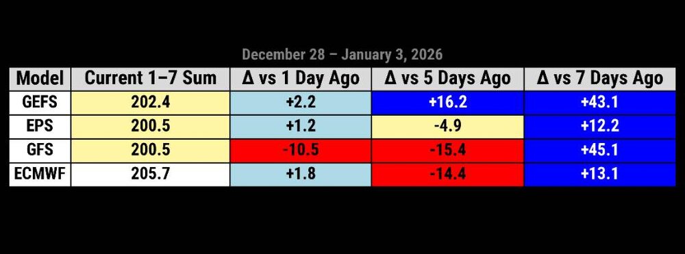
Over the past week the GEFS has gained 43 points for the upcoming 7 day stretch. Just an absolute swing and a miss for the American data on the transition into the New Year. This is from BAM weather. The American model has absolutely sucked. Even the EURO from only 5 days out has struggled a ton. This is a huge red flag for mid to late range guidance. A lot of volatility with the models. Sent from my SM-G998U using Tapatalk
-
Chances are higher than this past week lol.
-
@buckeyefan1can you pin this thread and unpin the old thread. Thank you.
-
Yes sir!
-
58 degrees here already..thankfully things come crashing back around here on Monday.
-
Ready for the cold to come back.
-
Mid to long range be looking better and better.
-
Merry Christmas gang!
-
Yes that's why the mid range has been horrible. A lot of the models have done a 180 in the 7 to 10 day time frame from what they where showing some 2 day's ago.
-
So you're saying the weeklies are volatile?
-
@wncsnow
-
Mmmm did you not see Larry's post?
-
We are seeing a trend though to colder and much colder. It's a trend not just one run.
-
Ain't no hopium about it. Never a guarantee for snow especially yall that live in a snow hole.
-
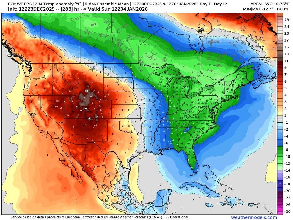
The old 10-15 day EPS rolled into the new 7-12 day forecast from the EPS. Again and again we've seen this especially this season and yes I'll die on this hill. Sent from my SM-G998U using Tapatalk
-
EPS supports the Euro and that's not a really warm look in the long range. Sent from my SM-G998U using Tapatalk
.thumb.jpg.b418b25a4b386e8a530c83d59507aa13.jpg)
.thumb.jpg.b199f0628ec73b1eb1bcdd320e553d30.jpg)
.thumb.jpg.2e7c0655ec573d05b13f2a3d58b6b45c.jpg)
.thumb.jpg.ce97d3239906bd1e346edc60cc9df433.jpg)
-
Whiplash anyone! Sent from my SM-G998U using Tapatalk
-
This is exactly what I've been talking about this week. We've seen this time and time again. And especially on the EURO We've seen even colder solutions in the mid range. Some people are gullible.
-
Euro with two back to back very strong fronts coming in after Christmas now.
-
Looks like we get multiple fronts coming through after Christmas now and more pronounced.
-
Possibly the northern mountains but at this time the cold front looks dry. Unless your into skiing then somewhere like Beech mountain. But at this time the models aren't showing any winter weather around New Years.
-
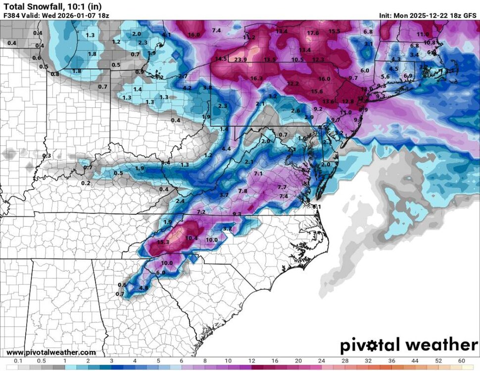
18z gfs snowfall Sent from my SM-G998U using Tapatalk
-
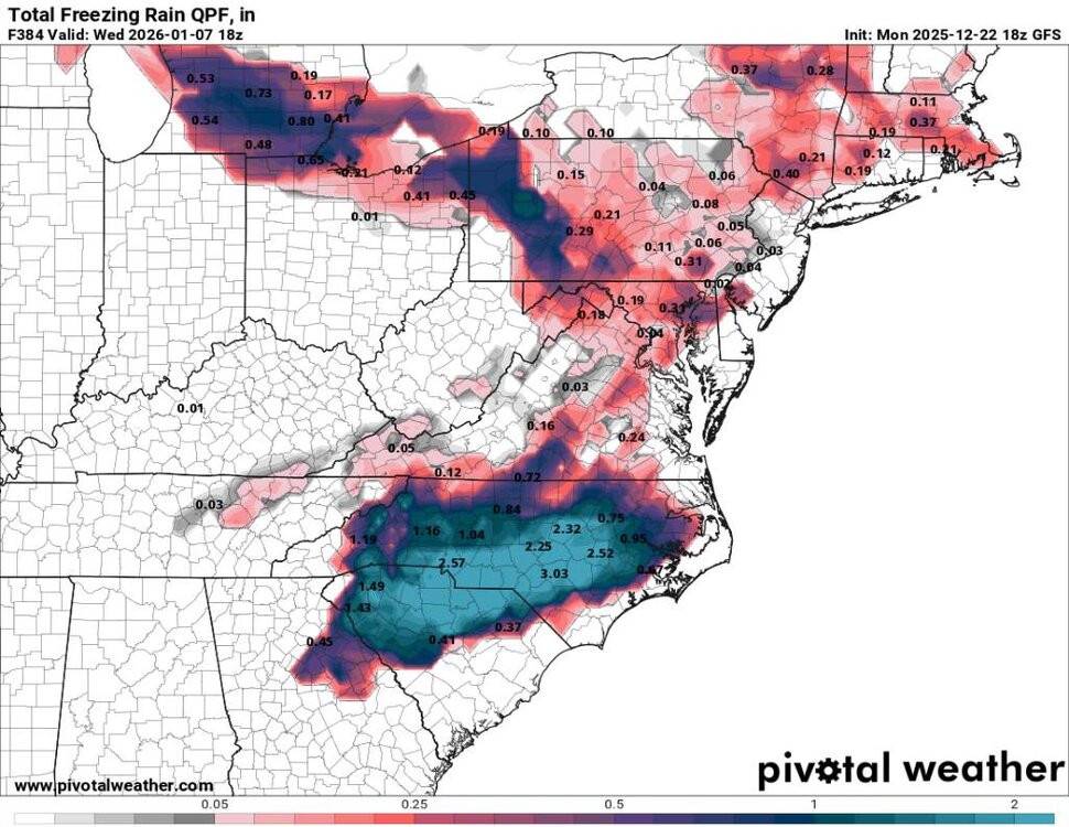
18z freezing rain map. Sent from my SM-G998U using Tapatalk
-

December 2025 Short/Medium Range Forecast Thread
Met1985 replied to John1122's topic in Tennessee Valley
That's freaking awesome.


.jpg.5ccae67cb51a5eeb790b0f01b979e0b3.jpg)
.jpg.7698da87018a7eb055ef01eb9a51f8b2.jpg)
.jpg.c688a3b53cd961db080321be95a64a02.jpg)
.jpg.6fd8f0d54e4bf435807e9ea3de90ae47.jpg)


