Met1985
-
Posts
16,974 -
Joined
-
Last visited
Content Type
Profiles
Blogs
Forums
American Weather
Media Demo
Store
Gallery
Everything posted by Met1985
-
Yes sir!
-
That severe drought should be eroding away quickly.
-
I just read where Mt. Airy East just got hammered yesterday. Radar estimates of over 10 inches.
-
Storms really starting to pop overnight to our west.
-
A low of 51 degrees this morning! Absolutely beautiful!
-
Had a high of 75 degrees and a current temp of 62 degrees!
-
Confirmed tornado hits Madison County according to the survey damage by the NWS. https://wlos.com/news/local/tornado-weather-western-north-carolina-storms-madison-county-ef0-wind-rain-damage-flooding-severe-wnc-warning-national-community-nws-meteorologists-summer-noaa?fbclid=IwdGRjcATYr61leHRuA2FlbQIxMQBzcnRjBmFwcF9pZAwzNTA2ODU1MzE3MjgAAR43g0vdv8HZ29w7O6ZOgNdG7JXG4ev0InBQaVObU2zrxKpC8zD9uDo_LIAPEQ_aem_casHDbmmg0Su4Oc2YZYfdA
-
Yeah talk about flipping a switch on. Not just for yall but for a good portion of the state from the mountains East have made a remarkable recovery just the past 30 days and like you said it looks like the faucet is set on for a good portion of August hopefully.
-
Huge improvements on the current drought monitor for several of yall down east.
-
Big improvements to the drought in our area.
-
Im up here in Mitchell County today. Current temp is 71 degrees with low humidity and a breeze. Absolutely gorgeous.
-
A beautiful 55 degrees this morning.
-
Had a high of 77 today with a current temp of 65 degrees.
-
We dry out a few days before we get back into more rainfall. This is a drought buster pattern. Asheville has nearly 9 inches This month and Raleigh has nearly 13 inches which is more rainfall in 1 month than the past 6 months combined.
-
I knew if we could get some sun we'd be cooked. From west to east. Some crazy cells popped up and extremely heavy rainfall.
-
Lake Fontana?
-
I took down the funnel cloud picture because a lot of people are saying it AI so we will see.
-
Tornado warned cell near Robbinsville currently.
-
things are going downhill in Asheville currently.
-
Tornado warning for Asheville!
-
Graham County looking to get smacked good with large hail.
-
Already some big storms popping up in TN. Obviously the sun is making things unstable.
-
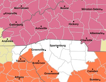
Game on! Sent from my SM-G998U using Tapatalk
-
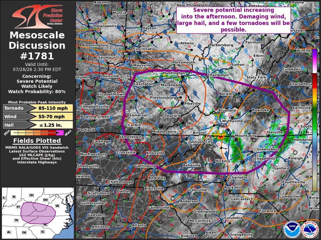
Fresh off the press! Sent from my SM-G998U using Tapatalk

-
Sun is completely out here. Should be doing it's job with the atmosphere. It's sticky all of a sudden.