

Amped
-
Posts
14,582 -
Joined
-
Last visited
Content Type
Profiles
Blogs
Forums
American Weather
Media Demo
Store
Gallery
Everything posted by Amped
-
Just like december 2013.
-
I think they are exaggerating totals a bit because its a high impact event with temps well below freezing and a lot of precip.
-
The dry patch is my concern more than the temps. The bust scenario is we get weak sauce before the changeover.
-
Euro front band is nuts for you guys. It moves through quickly but its 3"/hr min over those 2 hours.
-
Apple Weather is like if Joe Bastardi were a weather app.
-
The good thing about this storm is its moving in a strait line which means it should be a very extrapolatable setup. If its warmer/colder aloft than expected over the ms valley, its a pretty safe bet the same thing will happen downstream.
-
Rgem still has like 8 before the changeover.
-
Ecmwf, Rgem and even the Nam usually handle warm air aloft better than the GFS.
-

January 24-26: Miracle or Mirage JV/Banter Thread!
Amped replied to SnowenOutThere's topic in Mid Atlantic
All models have a gulf coast disturbance and a cold high. If it phases the sky is the limit. Or maybe it just goes ots like last year. -
January 24-26: Miracle or Mirage JV/Banter Thread!
Amped replied to SnowenOutThere's topic in Mid Atlantic
The gfs is may blow chunks on this storm, but its gonna make up for it by nailing the 2/1 colossal east coast blizzard. -
January 24-26: Miracle or Mirage JV/Banter Thread!
Amped replied to SnowenOutThere's topic in Mid Atlantic
Gfs is the Lucy model of this storm. -
Goofus doing Goofus things.
-
January 24-26: Miracle or Mirage JV/Banter Thread!
Amped replied to SnowenOutThere's topic in Mid Atlantic
It would seem, with all the computing power availible out there today they could make a snowfall algorithm that actually works. Instead we have 10:1 maps and Kuchara maps. 10:1 Maps: Heavy sleet for a few hours, you get a foot of snow. Kuchara Maps: 0.12" qpf with a temp of 6F, 100:1 ratios, you get a foot of snow. Both algorithms clearly are going to exagerate totals in this case. There could and should be something better. -
Not liking this trend. Its shifted the jackpot substantial amount northwest since 12z yesterday, a couple more shifts were mostly ice.
-
Wouldn't really say that. Kind of a hold the line for now run.
-
Hm still posts?
-
Gfs brewing something big down south at 216.
-
Just got an alert on my phone for a winter storm watch.
-
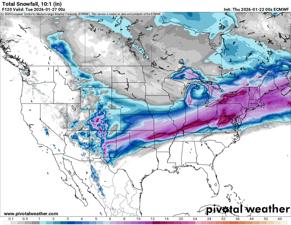
Huge snow swath. Starts right on the continental divide in New Mexico and goes all the way past eastern Maine
-
Cmc is my least favorite run so far. Ukmet and icon mix but at least they get a coastal transfer started early and track it well offshore. Cmc has the coastal too far west and not helping us.
-
I actually like this Icon run. The dryslot and the changeover hit at the same time north of I95, which means we dont waste a lot of heavy precip.
-
January 24-26: Miracle or Mirage JV/Banter Thread!
Amped replied to SnowenOutThere's topic in Mid Atlantic
The media is not picking up my storm name so I used AI to make a graphic for it. -
There is warm air all the way up to 700mb so the sleet line could be well north of there.
-
Ai gfs has something day 8-9
-
Great gfs run. Too bad its the outlier and its probably wrong.


