Amped
-
Posts
14,586 -
Joined
-
Last visited
Content Type
Profiles
Blogs
Forums
American Weather
Media Demo
Store
Gallery
Everything posted by Amped
-

Major Hurricane Melissa - 892mb - 185mph Jamaica landfall
Amped replied to GaWx's topic in Tropical Headquarters
The eye is closed off on radar now.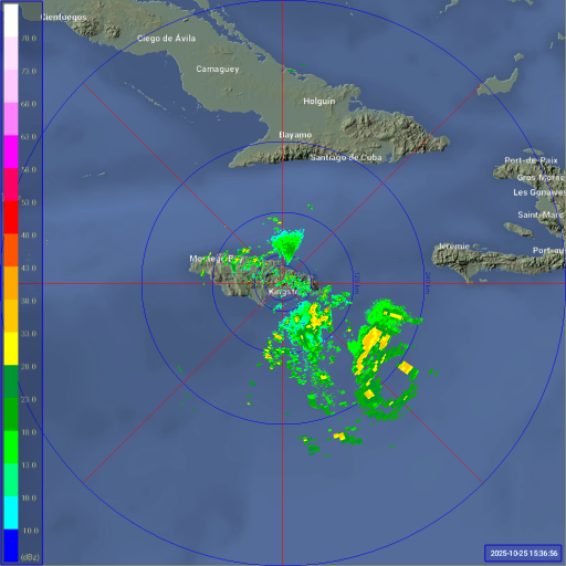
-
Major Hurricane Melissa - 892mb - 185mph Jamaica landfall
Amped replied to GaWx's topic in Tropical Headquarters
Yeah but there's a troff thats been keeping them separate. When it lifts out, it should result in both a west turn and a center alignment. -
Major Hurricane Melissa - 892mb - 185mph Jamaica landfall
Amped replied to GaWx's topic in Tropical Headquarters
1002mb usually isn't well defined. The Euro is not really showing much deepening until tomorrow morning. It probably becomes a hurricane tomorrow evening and a major by Sunday afternoon. -
Major Hurricane Melissa - 892mb - 185mph Jamaica landfall
Amped replied to GaWx's topic in Tropical Headquarters
No matter how far southwest it tracks, it turns right back over Jamaica. -
Major Hurricane Melissa - 892mb - 185mph Jamaica landfall
Amped replied to GaWx's topic in Tropical Headquarters
Jamaica will disrupt the core if it moves directly over it. 20 miles south or north and it may actually help consolidate the core and intensify faster. Also the eastern part has the highest terrain. -
Major Hurricane Melissa - 892mb - 185mph Jamaica landfall
Amped replied to GaWx's topic in Tropical Headquarters
There are still too much of a chance eastern track over western Hispanola like the ICON is showing to ignore. It wouldn't be the first time the Euro has missed a center relocation and shown a track way too far southwest. Not saying it will happen, just keep it in mind when posting 200kt Hafs A-B runs. They are going to look really bad if this turns into Cat1 Shrederolla -
I think the 12z GGEM might have been listening in.
-
Major Hurricane Melissa - 892mb - 185mph Jamaica landfall
Amped replied to GaWx's topic in Tropical Headquarters
It seems almost like something related to the diurnal cycle. A convective blob forms at night and pulls the center east. Then shear ramps up and rips it apart during the day and it drifts back west. -
Major Hurricane Melissa - 892mb - 185mph Jamaica landfall
Amped replied to GaWx's topic in Tropical Headquarters
The 12 Cmc pulls a Sandy. -
Major Hurricane Melissa - 892mb - 185mph Jamaica landfall
Amped replied to GaWx's topic in Tropical Headquarters
The 12z Cmc is probably just as far off with the track at 120hrs as the GFS, just in the opposite direction. If you average them you might get an accurate position somewhere southwest of Jamaica. -
Major Hurricane Melissa - 892mb - 185mph Jamaica landfall
Amped replied to GaWx's topic in Tropical Headquarters
It seems like the less latitude it gains in the next 72hrs, the more it gets tucked back under the ridge and bombs in the following 72 hrs, like the Euro and Cmc are showing. The Icon and Gfs show it gaining more latitude in the first 72hrs, then interacting with land when it tries to bomb. -
Major Hurricane Melissa - 892mb - 185mph Jamaica landfall
Amped replied to GaWx's topic in Tropical Headquarters
Recon not really finding a closed center. Clearly a low level circulation on the visible though at around 14.2N 72.8W and still zipping west. This would rule out the GFS solution if it keeps up for a few hours. -
Major Hurricane Melissa - 892mb - 185mph Jamaica landfall
Amped replied to GaWx's topic in Tropical Headquarters
Yeah it does not look like it's going to strengthen much in the near term. -
Major Hurricane Melissa - 892mb - 185mph Jamaica landfall
Amped replied to GaWx's topic in Tropical Headquarters
Surprised to see no models caving in yet. Gfs clearly shows too much intensification given the amount of shear, even if it's track ends up correct. Euro and Icon seem to have the middle of the road tracks where it stalls near Jamaica thats my current leaning. Cmc and Ukmet have a west bias, so they are the least likely Imo. Edit: The 12z eps has a lot of members with strong lows near the Honduras coast so maybe that solution has a better chance than I originally thought. -
Major Hurricane Melissa - 892mb - 185mph Jamaica landfall
Amped replied to GaWx's topic in Tropical Headquarters
Strangely the GFS has a second storm forming in the central Caribbean, so the GFS and Euro end up with a similar look at 348 hrs. Edit: The first storm on the GFS bombs out over PR in like 40kts of shear. Maybe it has a valid reason for doing this, but its a tough solution to believe at this point. -
All models showing something in the Caribbean next week.
-
The return of the elusive Nor'easter. Drought buster or bust?
Amped replied to dailylurker's topic in Mid Atlantic
00z Euro brought the storm back for NYC and NJ at least. We're still SOL. -
The return of the elusive Nor'easter. Drought buster or bust?
Amped replied to dailylurker's topic in Mid Atlantic
There's an inverted troff south of bermuda that is causing all the difference on model runs. The gfs and American models show it slowly moving north and dispersing it while the main coastal moves up into NC/VA. Non-American models are showing it quickly moving northwest and forming into a second low pressure somewhere well east of NC which shreds the other low closer to the Carolina coast One of the smaller features I've ever seen cause chaos in a forecast. Edit: 00z GFS initialization looks further west with that feature. It might be caving in.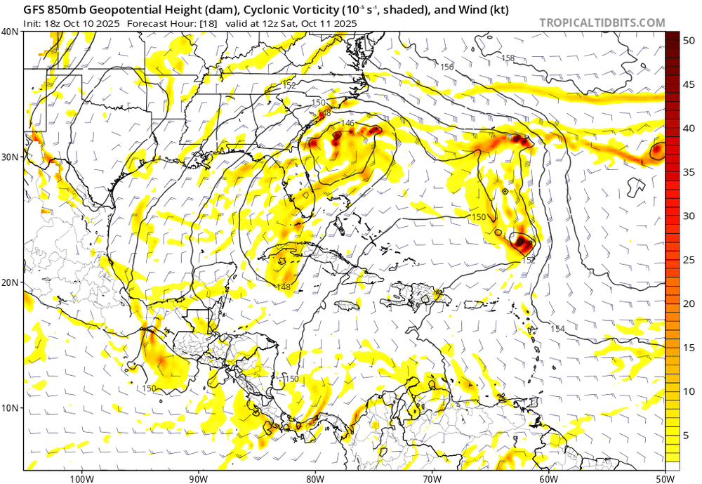
-
The return of the elusive Nor'easter. Drought buster or bust?
Amped replied to dailylurker's topic in Mid Atlantic
Medium range rug pulls is what our region does best. -
The IR almost looks like a copypasta of Dorian.
-
At least we have a 50/50 low

-
Hopefully the blob stays north of Ellicott City
-
Rain stopped. 1.7"
-
Letting up a bit after a solid 25 minute deluge.
-
One less model to make fun of.