

Snowstorms
-
Posts
4,126 -
Joined
Content Type
Profiles
Blogs
Forums
American Weather
Media Demo
Store
Gallery
Everything posted by Snowstorms
-
I agree. Perhaps the +AMO is playing a role in driving the SE ridge? The AMO has been positive since the mid 90's and could definitely be enhancing the SE ridge with the warmer Atlantic. Both the PDO/AMO were negative from the late 50s till the late 70's which led to many cold/snowy winters. Although the 80's and early 90's weren't particularly snowy, they featured a lot of cold winters which may have been driven by the -AMO.
-
I believe that WPAC warm pool may have contributed towards that as @bluewave mentions every so often.
-
I beg to differ. This winter seems typical of a strong El Nino. It may not finish as a "super" El Nino but it's definitely a strong El Nino, similar to 1972-73 and 1965-66, both of which fell short of super status. December 2009 was well below average across most of western Canada. Jan 2010 was near average for the southern Prairies and February 2010 finished below as well. Polar opposite of this winter. The "source region" was much colder with a solid snow cover hence it led to more snow for you guys in the Mid Atlantic/East coast as the AO/NAO block suppressed every storm. The block kept all of northern Canada warm but that's normal in a strong blocking pattern. Quite different than this winter where most of Canada will finish above average driven by a warm Pacific. https://climate.weather.gc.ca/climate_data/daily_data_e.html?StationID=28011&timeframe=2&StartYear=1840&EndYear=2024&Day=1&Year=2009&Month=12# See climate data in the link above. Regina averages -12.4/-14.7/-11.7C, respectively for DJF.
-
We haven't had a strong La Nina since 2010-11 despite seeing a multi-year Nina recently. So maybe it could. Things certainly changed since the 2015-16 super Nino which may have led to a warming effect across the entire pacific. 80% of the winter months (DJF) since 2015-16 have finished above average for most of us. I don't think the -PDO is the primary driver of this warmth. The PDO was ~75% negative from 1998-2014 and we saw plenty of cold winters (2000-01, 2002-03, 2004-05, 2008-09, 2009-10, 2010-11, 2013-14) and some featured incredibly cold winter months (i.e., Jan 2000, Jan 2004, Feb 2007). And during the last -PDO phase from 1948-1978, we saw plenty of cold winters.
-
A few days of snow on the ground after going nearly a month without any snow on the ground during prime winter isn't going to change my perception about this winter. A 7-10 day cold shot in January which was preceded by top 5 warm Dec-early Jan and warmth since then, won't make this winter seem any better. It's been truly garbage from start to finish. Two back to back incredibly warm winters and the 4th warm winter in the last 5 years. And the only truly cold winters, the ones that featured more than a 2 week cold shot, since 2015-16 were 2017-18 and 2021-22. But even those two featured incredible warmth (Feb 2018 and Dec 2021). It's crazy how many warm winters we've seen lately. This stat is even more profound for areas further east and north.
-
Wow! I did not realize how warm the Prairies were running this month. That's insane. 1877-78 was also a powerful strong/super nino. Well if our source region is running warm with little to no snow cover, you can't expect to see any sustained cold further east. Which is why I was always skeptical of any pattern change that was being modelled. I don't know if you recall, but the models showed something similar back in early-mid Dec 2015 too, but it never materialized. So far February 2024 is running to be the warmest Feb on record in Toronto.
-
@mississaugasnow All of the top 5 warmest Feb days at YYZ have occurred in the last 8 years lol. That's f*cked up. https://x.com/gtaweather1/status/1756061770123268267?s=20 Without a doubt, since the 2015-16 super Nino, we've experienced record breaking warm winters. It's hard to say if this is the new norm now, but certainly feels that way. Don't think we've experienced a string of cold winters, to the severity of the warm winters that we've experienced in the last 8 years, in a long time (since the early-mid 80s).
-
Today's GFS run is just depressing. No real snow or threats through Feb 20. Just looks cold and dry. We're about to go nearly a month without snow in the heart of winter. December was snowless too. Garbage.
-
That 2015-16 super Nino screwed things up and since then, the WPAC has been incredibly warm. Maybe a strong La Nina might offset the warmth and cool it down, idk? Despite the multi-year Nina, we haven't had a strong Nina since 2010-11. We had many cold winters during the last multi-decadal -PDO so I don't think it's the driver of this warmth. You can add 1917-18 to that list. I'll take a repeat of that winter. It was a La Nina following an El nino.
-
Forecast looks bleak. Next weeks storm looks to slide south of us and no real fantasy storm after that other than a weak clipper. With the amount of snowless weeks and the abundant sunshine and warmth we've seen over this past week, I'm ready for spring. Another one or two week long cold shot with little to no snow isn't going to makeup for this. 56 (13C) right now at YYZ on Feb 9th. Outside of that one week in January, it's been a total shit show. What a garbage winter and second record breaking warm winter. Almost like the stretch of warm winters we had from 1997-2000. Since that 2015 super nino, we've truly only had 3 cold winters (2017-18, 2018-19, 2021-22). The remaining 6 including 2015-16 were warm and in some cases, record breaking warm.
-
Goes back to one of your posts about the increase in extreme weather lately. Dec 2023 was incredibly warm followed by a record breaking cold outbreak, out west, and now more record breaking warmth for the same regions.
-
I live in between the 3 Great Lakes and ground is barren here in Toronto. I was up north over the weekend and only those downwind of the lakes (thanks to lake effect snow), have snow on the ground (4-6"). But with the warmth this past week and continuing warmth for the next 10 days, it'll all melt. No ice on the lakes either. I was in NYC/LI the last 2 days for a work conference. I didn't know it was gloomy here too.
-
How much snow did Detroit receive in Dec 1877? Dec 1877 is the least snowiest ever on record here with only 0.3". Dec 1877 is the 7th warmest on record here. 2015 and 2023 take the cake for top 2 though. 1889-90 was the warmest of the 4 winters you mentioned with a mean DJF temperature of 30.3F in Toronto. I haven't looked at the warmest/coldest winters in Toronto yet. I only have for YYZ (going back to 1938). The 30.3F would make 1889-90 the 4th warmest on record, behind 01-02, 11-12, and 15-16, respectively, since 1938. However, temperature records, especially over the last 30-40 years would definitely be impacted by UHI and urbanization, especially overnight lows. I don't know how applicable this principle would be for Detroit, but most major weather stations are either in the city or at the airport which can cause a "heat island" effect. Not trying to discredit climate change here though. But seeing how warm some of those 1800 winters were that you mentioned, in a time where there was no "industrial revolution" or "UHI" is pretty impressive.
-
Damn. Seems like the warmth has been centered around Minnesota and further NW this month. Our warmest high this month was 43. Last time we hit 50 was Dec 15. Nonetheless were going to finish January 7 degrees above average lol.
-

Winter 2023/24 Medium/Long Range Discussion
Snowstorms replied to Chicago Storm's topic in Lakes/Ohio Valley
Tonight's GFS is snowless for all of us until Feb 15 or all 384 hours. Nice. -
And the next 10 days look snowless too. Unless things turn around late Feb and March, were currently on track for a top 5 winter. Your call still going strong haha. Below is the Toronto station (going back to 1840). https://climate.weather.gc.ca/climate_data/monthly_data_e.html?hlyRange=1953-01-01|1969-05-31&dlyRange=1840-03-01|2017-04-27&mlyRange=1840-01-01|2006-12-01&StationID=5051&Prov=ON&urlExtension=_e.html&searchType=stnProx&optLimit=specDate&Month=1&Day=1&StartYear=1840&EndYear=2022&Year=1870&selRowPerPage=25&Line=21&txtRadius=25&optProxType=navLink&txtLatDecDeg=43.677222222222&txtLongDecDeg=-79.630555555556&timeframe=3
-
@mississaugasnow When I actually went back and tallied up all the winters in Toronto since 1840 I couldn't believe it. Almost wanted to rage lol. A lot of the winters in the 1800's were incredibly snowy and cold especially from 1864 to 1877. Toronto averaged 224cm (88") in this 13 year period lol. Out of those 13, 4 were >100". It's even more ridiculous when you extend the timeline. From 1843 to 1877, Toronto averaged 72" or 184cm in this 34 year period. The least snowiest winter in this entire stretch was 35". Fooking crazy. No other period in history has come remotely close to this. And I can't explain why. Maybe little ice age hangover?
-
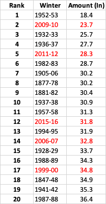
Yes I agree. Some weak or moderate El Nino's can be great for us too. Sorry it took me a while to get back to this, had to total up all the winters since 1840 in Toronto lol. Here's our top 20 least snowiest winters. Note I did not use YYZ for the top 20. I used our Toronto station, from 1840-1994 and then used our North York station from 1994-present. The red highlighted are the more recent winters (i.e., since 2000). Our average snowfall every winter is around 50" (45" at YYZ). If I used YYZ then 2011-12, 2009-10, and 2006-07 would be in the top 5. But YYZ's measuring standards are questionable.
-
Winter 2023/24 Medium/Long Range Discussion
Snowstorms replied to Chicago Storm's topic in Lakes/Ohio Valley
Statistically speaking, every winter month (DJF) except Feb 2021, and Jan/Feb 2022 has finished above average (temperature wise) since 2019-20. That's an ugly stat. It's even uglier if you go back to 2015-16. Only 4 more months (Jan 2019, Jan 2018, Dec 2017, and Dec 2016). More like light snow events that in some winters would be considered average (i.e., ~2"). And the next 10 days look warm and snowless. If we want to specifically filter out for strong Nino's, then January 1992, January 1988, and February 1973 had more impressive cold outbreaks. January 1966 was probably the more impressive one because the month finished below average. -
Winter 2023/24 Medium/Long Range Discussion
Snowstorms replied to Chicago Storm's topic in Lakes/Ohio Valley
Maybe for Chicago, Iowa, Wisconsin, and further west, but it wasn't anything special for us further east. Our average low in Toronto is 12F right now and the coldest we got was 4. I'm sure the same could be said for Detroit with the exception of 2-3 cold nights where you dipped below 0. And it only lasted a week. Now we are back to reality (continuing warmth). And it'll likely erase any negative departures for Detroit. -
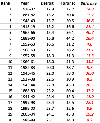
Thank you for sharing. I compared your top 20 to Toronto to see how/where we differ and I must say I'm shocked lol. Our average is around 45-50". All your top 5 winters were incredibly warm in Toronto too, with the only exception being January 1966. We had a big storm in Jan 1966 that dropped 16-20", more than your entire season, wow! Seems like we got really lucky in those winters due to marginal snow events, sort of like last winter. Another thing that stands out is; Detroit doesn't do well in El Nino's or neutral ENSO winters. Of your top 10; 5 were El Nino, 1 La Nina, and 4 Neutral. And that rule is more or less applicable for us in Toronto too. Though some El Nino's can be quite good (2002-03, 2004-05, or 2018-19 to name a few). I would think the inverse is true for your top 20.
-
Yeah I agree. 52-53, 06-07, 09-10, and 11-12 were unusually low and snowless winters. Almost anomalous when considering the other top 6. I hate to group 09-10 in there, even though stats say otherwise, cause that winter was just bad luck/timing for us in Toronto. Many places south and north of us did decent that winter. That big cluster includes 15-16 and 01-02. 15-16 got saved by that April snowstorm and 01-02 got saved by that late January storm that dropped 8". Both were incredibly warm. Some other historically bad winters include 1932-33 where only 25.7" fell. And 1936-37 was pretty bad too. Only 13" fell between DJF combined. 1937-38 was bad too. You're right about April snow. Big April snow is rare. Since 2005 (the last snowy April), we've only had two respectable snow events in April (2016 and 2022). 2018 was that ice pellet storm that dropped 4".
-
What are the top 10 least snowiest winters in Detroit?
-
YYZ at 14" as of yesterday. About 3" away from 2011-12 and 7" away from the next lowest seasons (09-10 and 52-53). They got lucky with the clipper snow this past week but nothing special. The two big storms we saw earlier in the month were both primarily rain followed by a 7-8 day cold shot, which for the most part, wasn't really exceptional, even by Detroit standards where they've experienced far worse (i.e., Jan 2022, Jan 2019, or early Jan 2018). Now back to the warmth this week and next which has become a common theme in the last 4/5 winters. Not a fan of April snow. Let's take Detroit for an example. The average high by early April is around 50F or higher. That's almost 20 degrees above freezing. Any snow that falls will melt within a few days max and snow ratios suck.
-
That's great. We're getting heavier snow now. Been on and off throughout the day but close to 2" so far.

