

Snowstorms
-
Posts
4,126 -
Joined
Content Type
Profiles
Blogs
Forums
American Weather
Media Demo
Store
Gallery
Everything posted by Snowstorms
-
2008-09 and 2011-12 were second year La Nina's preceded by much stronger La Nina's the year before. So I don't know if that matters from an analog perspective. 2016-17 hardly lasted for more than 5 months and only bottomed out at -0.7. 2016-17 could be an analog depending on the strength but that's far out anyways.
-
Great post. There's been a lot of comments about the warmth in the last couple of winters being driven by the -PDO but I don't think so. Just a quick glance at the SST maps can tell you how atypical the current -PDO looks despite a deeply negative anomaly. I believe the period between 1998-2014 was the last time we had a true -PDO phase and it was quite reflective in the Pacific ssts. And we experienced several cold winters in that period especially from 2007-2015. Maybe a strong La Nina may shift those anomalies and also drive down Pacific SST's especially off the coast of Japan and in the WPAC. The warm Atlantic and +AMO don't help us either. A poleward Aleutian ridge if linked with Atlantic blocking can be beneficial for the east too. It may not be a super cold pattern as the EPO would be neutral, but it would be below normal overall. If I'm not mistaken, we saw that in December 2010.
-
Probably won't last for more than a few days to a week. Models have been advertising a "pattern change" or "cold air" in the medium-long range all winter going back to December and it never came to fruition except for a brief 7-10 day period in mid January. Outside of that, it's been historically warm. I'm not sold on any real pattern change for us right now. Even 2015-16 had more cold periods in JFM than this winter despite an historically warm December. However, early April 2016 was quite cold.
-
Pretty telling and concerning 7 of the top 10 warmest winters are in the last 27 years and 5 in the last 13 alone. Although a few others did not make the top 10 for Detroit, there's several other warm winters or winters with an abnormally warm month in that 27 year span including 1998-99, 1999-00, 2005-06, 2012-13, 2019-20, and 2020-21. Warmth is one statistic and snow is another. I'm more concerned about the warmth and its severity and longevity during the winter season than whether we end up with above average snow. Because if we continue on this trend, we won't see many snow cover days or may struggle with precip issues with every storm. The period between 2007-2015 was the only real cold period filled with snow/cold that we honestly had since the 90's. And many of the 90's winters were shit too.
-
At this point, anything will be better than this winter's monstrosity. I'd take a repeat of 98-99. Biggest problem for me is that it was a warm winter too and I'm sick of these constant warm winters. But we had that blizzard in January 1999 that dumped 16-20" in Toronto and cued one of the snowiest 2 week periods ever in Toronto for a total of 46" in just 14 days. Kind of similar to Feb 2015 for you guys.
-
YYZ only goes back to 1938. Here's the top 10 for Toronto going back to 1840. I used Toronto till the mid 1950s and YYZ thereafter because of the continued industrial revolution skewing anomalies. As of now 1931-32 holds the title for us. I guess you could make an argument that those pre 1955 winters if they happened today with all the UHI, they would be a lot warmer. Therefore, for that time, which is considered to be a much cooler time globally, those winters were incredibly warm vs normal. We lucked out in 1965-66 with 27" in January but snowfall outside of January was abysmal. And 1957-58 was shit here too, snow wise. Temperature wise both winters finished slightly above average but not by much. We finished near average for 1972-73 too, primarily thanks to a snowy November and December where 60% of our winter snow fell in those 2 months. I made a post in the other thread about strong Nino's. Every strong/super Nino since 1982-83 has been an absolute blowtorch across North America. Quite the opposite with other notable strong Nino's like 1972-73, 1965-66, and 1957-58. It seems like 1982-83 was the tipping point. Though aside from the temperature anomalies, one thing remains constant. They were all largely snowless for the entire region. We seem to fair much better and snowier with strong La Nina's. Of the majority of YYZ's top 10 snowiest winters, most are strong Nina's. I'd assume it's the same for Detroit.
-
Where does 2022-23 and 2016-17 stand on the rankings? Locally, 2023-24 was the warmest on record here in Toronto at YYZ. Though records at YYZ only go back to 1938, I'm positive 2023-24 is in the top 5 or top 3 if I looked at all the records that went back to 1840. Of the top 8 warmest on record at YYZ, 5 are since 2015-16 which include 2015-16, 2016-17, 2019-20, 2022-23, and 2023-24. Fucked up lol. I know you make a lot of reference to 2015-16 so I wonder if this is just a hangover from that super Nino on the globe and global oceans or has the warming simply accelerated. The amount of warmth and warm winters we've seen in the last 8 years is absurd. We saw a similar thing with the 1997-98 super Nino. From 1997-2007, we only saw 2 cold winters across the continent (2000-01 and 2002-03) and one near average (2003-04). Although we experienced the multi-year Nina (1998-2001), it may have not been enough to counter the warmth that built up from the 3 strong Nino's vs one strong Nina from 1986-1998. Until the 2007-08 strong La Nina did we enter a period of colder winters from 2007-2015 and only really experienced one warm winter (2011-12). I'm talking about all of North America not locally. I don't think the -PDO is responsible for any of the warmth. The PDO was predominately negative between 2007 and 2015 and we experienced 90% cold winters. You made a post about strong Nino's stepping up global temperatures and I think it maybe partially to blame for the recent increase in warm winters. The 2015-16 super Nino may have greatly impacted ocean temperatures enhancing the +AMO and ultimately the SER which has been on steroids since. It may have also altered the usual -PDO, as even though numbers may say otherwise, only 2020-21, and 2021-22 looked like a full fledged -PDO across the Pacific (like 2007-2015 did). One simple look at the current SST map can tell you that despite the deeply negative anomaly. One can say the same thing about the MEI values hardly cracking moderate status despite a super Nino ONI value last tri-month. Basically we need a 2007-08 or 2010-11 type of La Nina to cool the oceans down. I think.
-
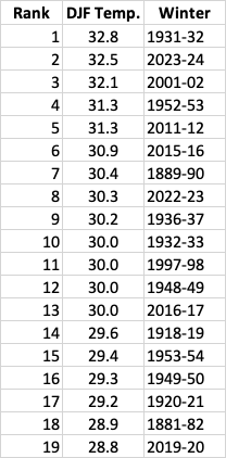
This winter (DJF) is officially the warmest on record at YYZ with a mean temperature of 32.5 (0.3C) and 0.5 ahead of the previous record holder (2001-02). Other top 6 winters are 2011-12, 2015-16, 2022-23, 1997-98, 2016-17, and 2019-20. 5 of the top 8 have been since 2015-16 which is fucked. @mississaugasnow Either the warming has exponentially accelerated or this is just a result of the 2015-16 super nino hangover on the globe. Hard to say right now but facts are facts. Winters are getting warmer. Only 2013-14 and 2014-15 are the two recent winters to be in the top 12 coldest at YYZ. Everything else is pre 1982. Snow is nothing more than just a byproduct of the existing pattern. It takes just one or two storms or a "snowy" week to change the outcome between a snowless and snowier winter. We saw that perfectly this winter. The warmer oceans maybe playing a role in enhancing storms. But if we continue on this warming trend, at some point, snow will play catch up and we'll have to constantly deal with marginal temperatures and mixing. 1972-73, a key analog some have used for this winter, was considerably colder across the entire continent. And some other notable strong Nino's (1965-66 or 1957-58) were also considerably colder. The 1982-83 super nino changed the game and every strong/super Nino since then has been incredibly warm.
-
GFS continues to look snowless. Would be remarkable if we go the entire rest of March and April without any winter storm. i don't think there is any winter that went snowless after mid Jan and that too coming off a snowless December. Outside of a weak clipper in mid Feb, it's been incredibly warm and snowless. @mississaugasnow Pretty much unheard of at our latitude.
-
I do agree we had a nice stretch of cold/snowy winters for a period of time between 2008-2015 and a few others since the start of the century (2000-01, 2002-03, and 2004-05). But the severity of those cold winters don't compare to the severity of warm winters we've experienced since the late 90's and I'm not just talking locally but nationally. 2023-24 is about to be the warmest winter on record across the nation and is on the heels of other recent warm winters like 2022-23, 2019-20, 2016-17, 2015-16, 2011-12, 2005-06, etc. All of these winters are different ENSO types too. Maybe certain locales may not be breaking warm records but in broader context, it is historic given the shear number, longevity, and severity of warm winters. It isn't always about the records but rather the continuing (+) anomalies. If trends continue, at some point, snow will catch up. Can't constantly have marginal snow events as our climo should be and has supported colder snow.
-
December till mid Jan was cloudy and warm. That changed since late January when the omega block set up and skies cleared up. A nice change from where we started and what we've experienced over the last few years. Warm and cloudy is just ugly.
-
@mississaugasnow As of yesterday YYZ is at 0.1C for DJF making it the warmest winter on record (since 1938). The final 9 days will likely seal the deal with the impending warm up. Of the top 5 warmest winters on record at YYZ, all 5 have occurred since 2001-02 with 4/5 since 2011-12. And 9 out of the top 10 warmest have occurred since 1998. That's fucked up. You can only ascertain a portion of the warming due to UHI, but the rest of it is climate change. Kind of scary how fast winters are warming. If we continue on this trend, at some point, snow will play catch up. We saw that last winter and 2019-20 with all the marginal snow events, but this winter kind of exposed that more. It's only a matter of time. Hope nature finds its equilibrium and things shift.
-
This winter sucks. 2019-20 we had a neutral and it was also warm.
-
Wow, I find it interesting Toronto began recording in 1840.
-

Winter 2023/24 Medium/Long Range Discussion
Snowstorms replied to Chicago Storm's topic in Lakes/Ohio Valley
Quite the opposite here. We had a total of 5 days over 50, which in itself is historic for February for our area. It wiped all the negative anomalies from the first 14 days here too. If February 2018 finished on Feb 14, it would've finished 2 degrees below average. Quite the flip. -
We have the exact same issue here in Toronto. They lowball every storm at the airport location, which is our main reporting station. It's really problematic. For example, during the Feb. 2013 storm, YYZ only recorded 8.6" whereas every other station recorded 15-20". YYZ became operational in 1938. 2007-08 was officially about to be the snowiest winter on record at YYZ but they lowballed the March storm by 8" and we fell short of the record by 5" lol.
-
I agree. 2006-07 started off incredibly warm and the Feb cold wasn't enough to erase the warmth. 2007-08 may have been warm for us out east but it was cold across the plains and further west. I'd say it started with 2000-01 as it was quite cold. 2005-06 and 2012-13 were also warm too. 9/15 winters between 2000 and 2015 were cold whereas in the last 8, only 1-2 winters were cold. Quite the flip.
-
Winter 2023/24 Medium/Long Range Discussion
Snowstorms replied to Chicago Storm's topic in Lakes/Ohio Valley
Where does the mid-late February 2018 warm up stand? -
Winter 2023/24 Medium/Long Range Discussion
Snowstorms replied to Chicago Storm's topic in Lakes/Ohio Valley
I agree. '83, '98, and '16 all had similar type of March patterns. As @michsnowfreakmentioned all three had a cool down sometime mid-late March. Although in 2016 it happened in early April. But no guarantees it will happen this year. This winter has been on life support since it started. -
That WPAC warm pool only became an issue after the 2015-16 super nino. We saw several cold winters between 2000-2015. Perhaps a strong Nina may help to cool it. We just came out of a multi-year Nina but they were all weak except 2020-21 which was moderate. I'm just grasping at straws. I'm tired of these warm winters myself.
-
Wow. Yeah you're right and tonights GFS has zero for the next 15. At this point I'm hoping for a full on torch for spring.
-
I hope the warmth is temporary. One thing that seems apparent to me, and I think this principle can be applied to many places, is that we seem to be seeing a lot of micro trends. Like one region goes through a drought for a period of time then a wet period, etc. This WPAC warm pool really became an issue after the 2015 super Nino. Maybe a strong Nina, since we haven't seen one since 2010, might help cool it down? From a national perspective, we saw several cold/cool winters from 2006-07 to 2014-15 (2007-08, 2008-09, 2009-10, 2010-11, 2013-14, 2014-15). Quite the opposite from 2015-16 to present.
-
Winter 2023/24 Medium/Long Range Discussion
Snowstorms replied to Chicago Storm's topic in Lakes/Ohio Valley
Yeah would be quite historic too. But the way this winter has gone, I wouldn't be surprised if we saw a warm March like 2010 or 2012. -
That GFS 384hr total snow map is depressing. Stick a fork in this winter, it might be done.
-
The February 2013 storm is a prime example of this. Clipper and coastal phase due to an active N stream.

