Snowstorms
-
Posts
4,126 -
Joined
Content Type
Profiles
Blogs
Forums
American Weather
Media Demo
Store
Gallery
Everything posted by Snowstorms
-
What are NYC's top 10 coldest winters since 1950, irrespective of normals. 1976-77 is Toronto's coldest winter as well with a mean temp of 16.8 for DJF. 1969-70 and 1944-45 are tied for second and 1993-94 and 1977-78 are tied for third.
-
Most of us living in the Great Lakes are running warmer than normal this month when compared to the old 81-10 normals vs the blowtorched 91-20 normals. I've only gotten down to 8 so far this month, which is nothing impressive, given our average low of 13 currently. Those living in the path of the snow belts are doing amazing, snow wise. Most of us aren't. I've been fortunate enough, which is rare btw, to get a few lake effect streamers which have given me a grand total of 7" since Dec 1 of the total 17" for the season. The rest was cause of clippers, 1-3", here and there. It's crazy what consistently warm winters can do to lake temperatures.
-
Nice clipper, just wish we could've stolen some more moisture from that storm down south haha. Clipper'd and lake effect snowed my way to 17" and around 14" at YYZ on the season. Of the 17.6" at my place, about 7" is from lake effect alone. Still running below average though.
-
Nice to see the Mid-Atlantic snow covered. It's been a long while, happy for you guys
-
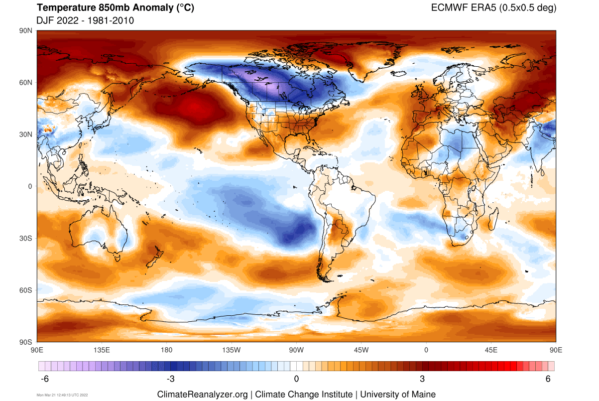
I think his idea of "canonical La Nina" are winters like 2022-23, 2011-12, 1999-00, or 1998-99 which were straight blowtorches, but they weren't necessarily because of an overpowered SE ridge. A true canonical La Nina winter has cold anomalies centered across the Upper Midwest, Plains, and Canadian Prairies and neither of those winters above had that with the exception of 2022-23 in a few spots thanks to a really cold December. A true canonical La Nina winter may feature warm periods in the east but equal amounts of cold shots or a cold winter month or two, i.e., Dec-Jan 2009, Dec-mid Feb 2018, etc. Temperature wise, 2021-22 was the last true canonical La Nina winter. The warm anomalies in the south are primarily because of a near record warm December. That was likely driven by an overpowered SE ridge, +AMO, and climate change.

-
Clipper overachieved here. Measured 3.8". Most areas of Toronto received 4-6" thanks to some lake enhancement. At least it finally looks like winter.
-
The areas that almost never have snow cover are about to have a snow cover while the rest of us in prime winter areas are bone dry. We were lucky enough to salvage some lake effect snow and 2 clippers in December, but were about to go half way through winter with only one snowstorm that impacted the region as a whole. Pretty crazy.
-
Thanks for the background. This winter is unmitigated disaster outside the snow belts and mid-atl.
-
It was. Idk, lake effect snow melts quicker. Maybe due to the water content? Tonight's low might get down to 0.
-
Got a surprise 2" today from a lake effect streamer. It has largely melted now.
-

Winter 2024-25 Medium/Long Range Discussion
Snowstorms replied to michsnowfreak's topic in Lakes/Ohio Valley
All the ensembles are indicating a pattern shift after the 15th. The PNA ridge begins to break down and a ridge begins to form around Alaska towards the Aleutians. This will shift the mean trough towards the plains and hopefully give way to a more stormier/active storm track for the sub in the final 10-15 days of the month. About the only silver lining I see right now.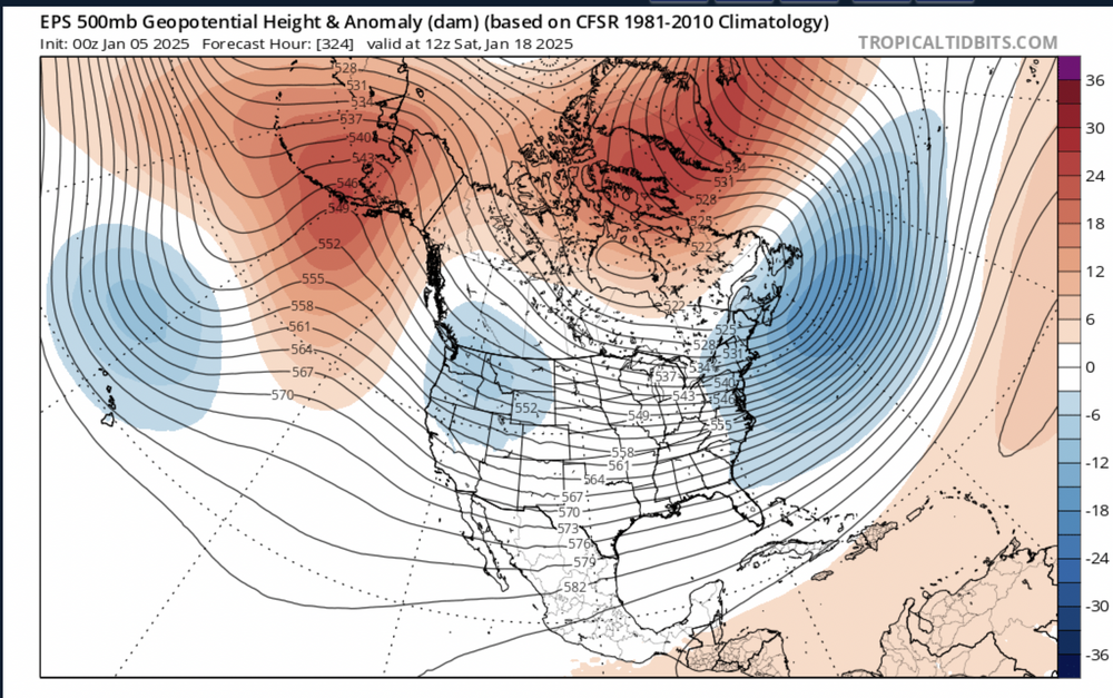
-
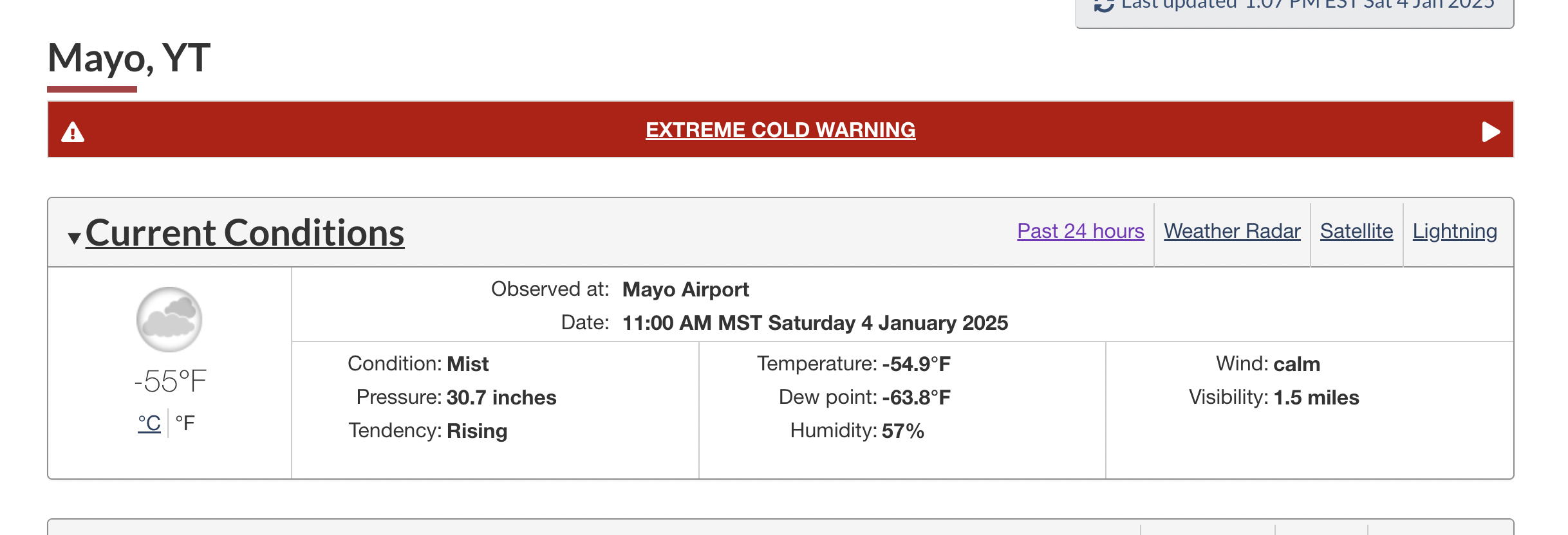
A bone chilling -55 right now with windchills close to -63 in Mayo, Yukon. At least the cold is on this side of the globe.

-
Winter 2024-25 Medium/Long Range Discussion
Snowstorms replied to michsnowfreak's topic in Lakes/Ohio Valley
That Euro total snow map till January 18 looks depressing for everyone in the Great Lakes, Ohio, and NE region outside of the snow belts. Hope things change in the last 10 days of the month. -
https://www.onthesnow.com/lake-tahoe/skireport 49% of normal so far and next 10 days look dry too. Whistler is doing bit better but looks to dry out too.
-
Except the snow belt regions in the great lakes, it's been bad everywhere. After Tuesday the mid atlantic are about to be ahead of 95% of the people living in the great lakes region.
-
Winter 2024-25 Medium/Long Range Discussion
Snowstorms replied to michsnowfreak's topic in Lakes/Ohio Valley
The lack of any decent or widespread snow cover maybe playing a role in that. Kind of similar to Jan 2011. Although it finished below average, their wasn't any extreme cold. I think ORD only got below zero once. -
Winter 2024-25 Medium/Long Range Discussion
Snowstorms replied to michsnowfreak's topic in Lakes/Ohio Valley
Agreed. I think the mid-atlantic likes strong nino's cause it beefs up the stj and even with marginal temps, they can "squeeze" in some miracle storm despite it being a complete disaster elsewhere. I think for us snow weenies, the next 1-2 weeks are going to be brutal coming off the December we had with nothing going on. But atleast it will be cold. I think our best chance might be next weekend, at the earliest. Both the GFS and CMC have some moving pieces thanks to the active but suppressed stj. What's key is if we can get a partial phase. -
Winter 2024-25 Medium/Long Range Discussion
Snowstorms replied to michsnowfreak's topic in Lakes/Ohio Valley
I think its the continuing bad winters we keep seeing thats getting to people's heads. These guys in the Nino thread last year were so amped that we finally got a Nino and it ended up being worse than the trifecta Nina that preceded it. -
Winter 2024-25 Medium/Long Range Discussion
Snowstorms replied to michsnowfreak's topic in Lakes/Ohio Valley
I am liking the subtle trends towards a neutral PNA as we get closer to mid January on the ensembles. The NAO block likely shifts from being west based to east based which should help as opposed to now where every storm is being suppressed. I think our best window of opportunity is between Jan 13 and Jan 25 as the +PNA wanes and an Alaskan ridge builds. Until then zzz. -
Fall/Winter '24 Banter and Complaints Go Here
Snowstorms replied to IWXwx's topic in Lakes/Ohio Valley
True we did and thats why I mentioned aside from clippers. Nicked and dimed our way to 22cm so nothing crazy. However, without any trackable storms over the next 10-15 days, the gap between our ytd and seasonal total will increase. By the end of January we should be averaging 25" or 65cm. I assume Chicago is probably around 20" by then too. Hopefully things change as the month progresses for all of us. -
Fall/Winter '24 Banter and Complaints Go Here
Snowstorms replied to IWXwx's topic in Lakes/Ohio Valley
After going December without any snowstorms, aside from 2 clippers, the next 2 weeks of January look cold and dry. Another mediocre winter so far. -
Winter 2024-25 Medium/Long Range Discussion
Snowstorms replied to michsnowfreak's topic in Lakes/Ohio Valley
Completely agree. I can't deal with frigid cold and barren ground. But this pattern is not conductive for big storms given the trough orientation other than maybe weak clippers and lake effect snow. Hope we can score something. I'm personally not a fan of +PNA patterns. -
Winter 2024-25 Medium/Long Range Discussion
Snowstorms replied to michsnowfreak's topic in Lakes/Ohio Valley
The biggest drawback with this cold could be the lack of storms with the way the trough is going to be positioned. And aside from warm torches in winter, I hate long cold/dry patterns. -
2 more days left including today, but December will likely finish 2-3 degrees above average. Our 7th consecutive warm December. Snow wise, we will finish about 2" below average. Only silver lining in this string of unprecedented warm Decembers, is that only 3 have finished below average since 2016 snow wise.
-
January 2000 was cold too with an intense cold outbreak that second half. I think central park was well below freezing for 7 days in a row.