andyhb
-
Posts
20,430 -
Joined
-
Last visited
Content Type
Profiles
Blogs
Forums
American Weather
Media Demo
Store
Gallery
Everything posted by andyhb
-
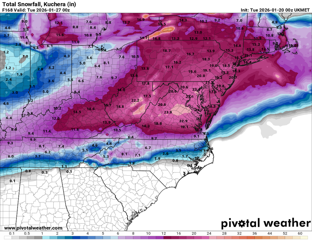
Yeah, that UK is pretty damn ridiculous on the Kuchera.
-
Bordering PDII levels on that UK run, deeper storm with a long period of heavy snow both in the WAA region and the deformation zone.
-
And for the knockout punch...
-
If you want a major storm, you want Tomer Burg talking like this. End of story.
-
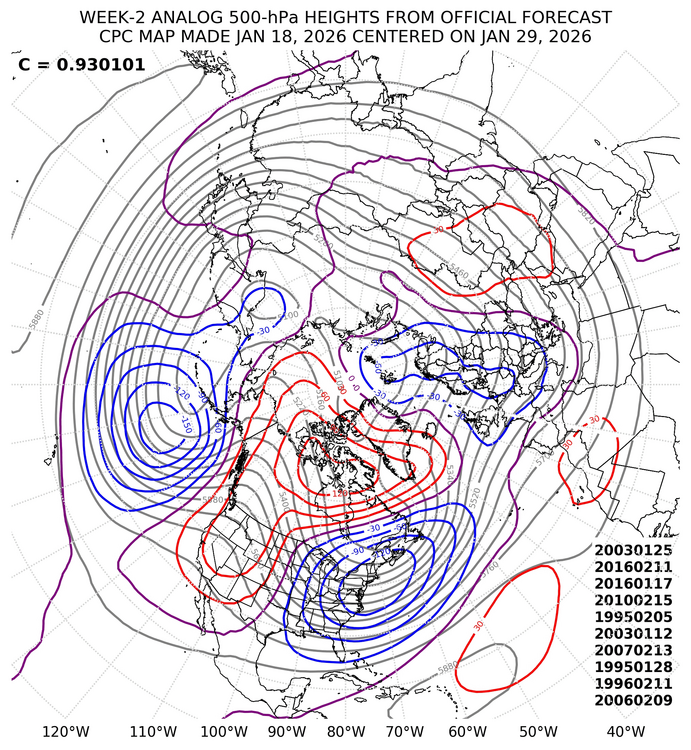
CPC analogs say snowbanks taller than Randy incoming.
-
Big west based -NAO with a lot of cold air present usually equals some kind of pay dirt, just uncommon in a Niña.
-
What in the 2010 hell was that AIFS run?
-
That is a catastrophic ice storm on the 12z Euro for this region and particularly Atlanta.
-

Winter 2025-26 Medium/Long Range Discussion
andyhb replied to michsnowfreak's topic in Lakes/Ohio Valley
Ok but seriously, what in the actual hell happened with that run? -
Nov 28-30th Post Turkey Day Winter Storm
andyhb replied to Chicago Storm's topic in Lakes/Ohio Valley
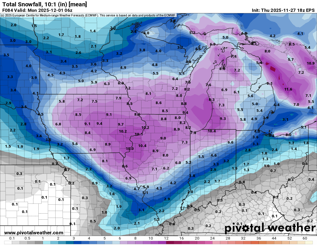
Jackpots of over 16” in central IA and S WI with this, seems like many areas got over 10” by the end of it.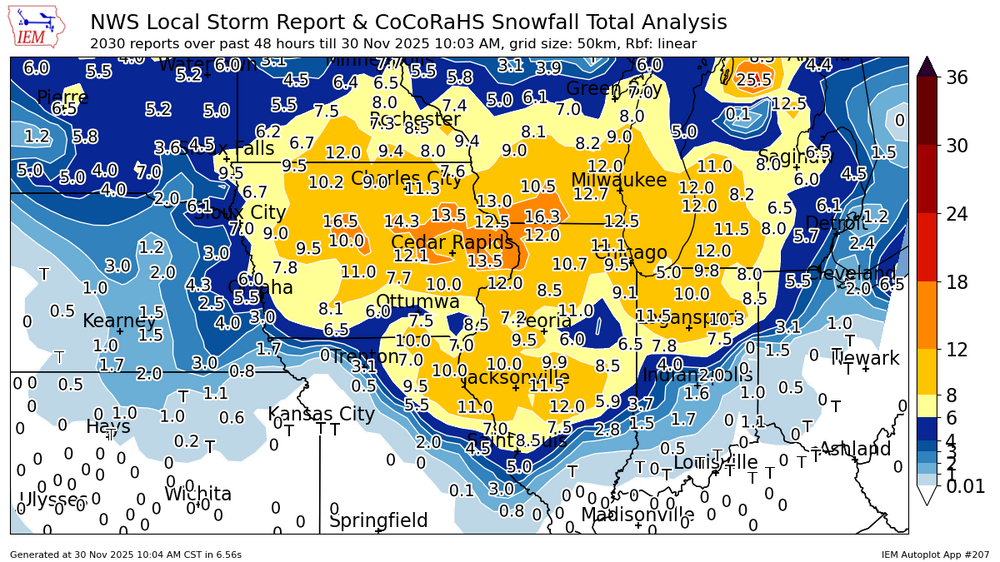
-
Nov 28-30th Post Turkey Day Winter Storm
andyhb replied to Chicago Storm's topic in Lakes/Ohio Valley
Looks like the advertised spread the wealth event is coming into fruition. Seems like N IN is doing pretty well compared to expectations, widespread 6-12" elsewhere. -
Nov 28-30th Post Turkey Day Winter Storm
andyhb replied to Chicago Storm's topic in Lakes/Ohio Valley
Des Moines looks like it’s getting hammered. -
Nov 28-30th Post Turkey Day Winter Storm
andyhb replied to Chicago Storm's topic in Lakes/Ohio Valley
18z EPS mean is 10" for the QC even at 10:1 ratios, pretty impressive considering I'd expect the ratios to be better than that through a good chunk of the storm. This will punch above its weight class SLP depth wise given the favorable dynamics aloft and very strong LLJ/WAA minus a lot of strong convection in the warm sector. Height falls look excellent on the 00z GFS.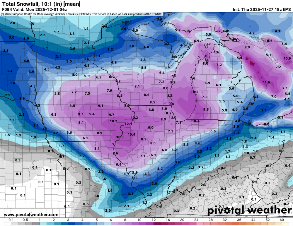
-
Nov 28-30th Post Turkey Day Winter Storm
andyhb replied to Chicago Storm's topic in Lakes/Ohio Valley
HRRR continues to be very impressive, albeit likely overdone. Verbatim would likely mean some pockets of 12-18" over IA and N IL/S WI. -
Nov 28-30th Post Turkey Day Winter Storm
andyhb replied to Chicago Storm's topic in Lakes/Ohio Valley
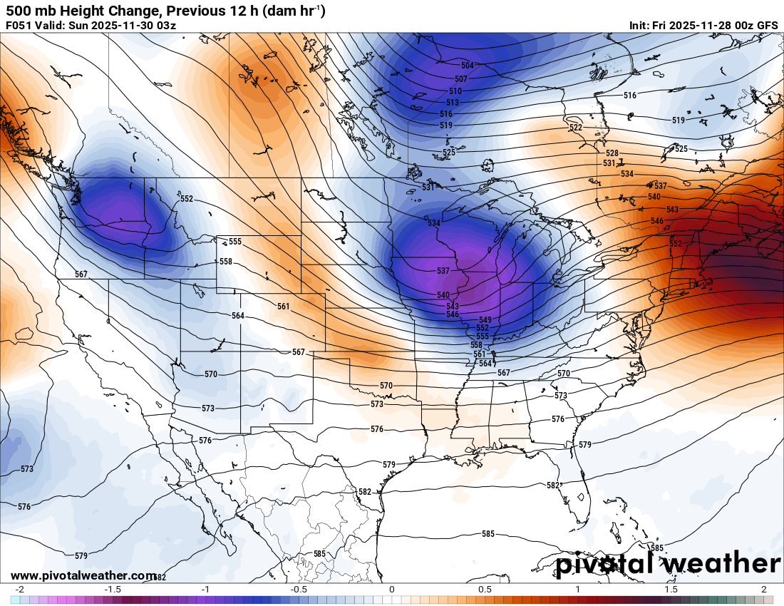
IIRC that wave had a deepening trend closer to verification as well as the PV lobe became better resolved, I remember having some back and forth with @RCNYILWX about it at the time. The issue this time is that the upstream ridge isn't quite as amplified as that, and there's a bit more phasing required here for a higher end outcome. -
Nov 28-30th Post Turkey Day Winter Storm
andyhb replied to Chicago Storm's topic in Lakes/Ohio Valley
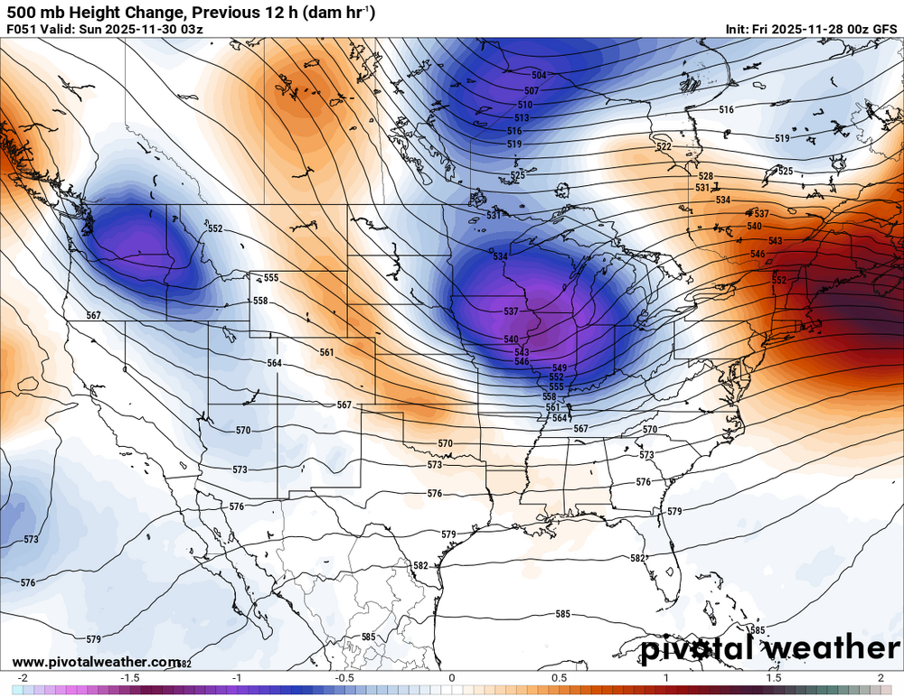
500 mb evolution with this does remind me a good deal of a slightly less impressive version of GHD II. Trough/jet streak matures in a very similar way and the thermos aren't terribly far off from that either. More likely to taper out with eastward extent though. -
11/8-11/10 First Snow and Lake Effect Event
andyhb replied to Geoboy645's topic in Lakes/Ohio Valley
Visibility is effectively zero on that Skydeck webcam now. -
11/8-11/10 First Snow and Lake Effect Event
andyhb replied to Geoboy645's topic in Lakes/Ohio Valley
How has no one said "rdy 2 b buried" yet? -
Major Hurricane Melissa - 892mb - 185mph Jamaica landfall
andyhb replied to GaWx's topic in Tropical Headquarters
Incredible and I mean incredible tree/vegetation damage from Melissa across a large area in this video. There's only a few TCs in recent memory that have produced damage on this scale. -
Major Hurricane Melissa - 892mb - 185mph Jamaica landfall
andyhb replied to GaWx's topic in Tropical Headquarters
The damage in this overhead imagery is pretty mind boggling. -
Major Hurricane Melissa - 892mb - 185mph Jamaica landfall
andyhb replied to GaWx's topic in Tropical Headquarters
This horrific damage from White House, Jamaica is right up there with the highest end I've seen out of a tropical cyclone. Near 100% structural failure/roof failure here.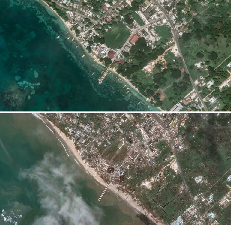
-
Major Hurricane Melissa - 892mb - 185mph Jamaica landfall
andyhb replied to GaWx's topic in Tropical Headquarters
Wait, recon made another turn. They seem to be trying to find a flight path around the strong convection on the east side of the CDO. -
Major Hurricane Melissa - 892mb - 185mph Jamaica landfall
andyhb replied to GaWx's topic in Tropical Headquarters
Annnnnnd recon bailed. -
Major Hurricane Melissa - 892mb - 185mph Jamaica landfall
andyhb replied to GaWx's topic in Tropical Headquarters
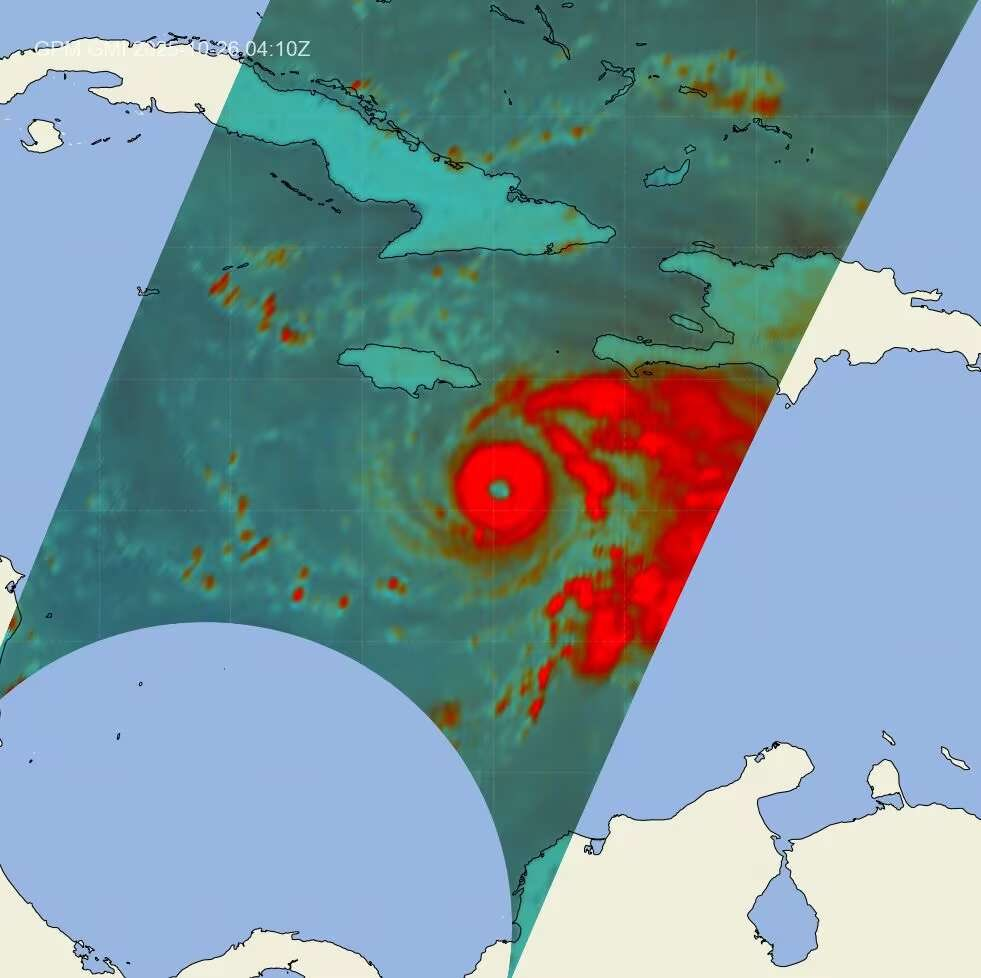
Bombs away with this microwave satellite presentation hot off the press. Very well organized inner core.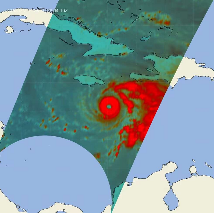
-
Major Hurricane Melissa - 892mb - 185mph Jamaica landfall
andyhb replied to GaWx's topic in Tropical Headquarters
The GFS has been notably an eastern outlier for the track for days now.