andyhb
-
Posts
20,408 -
Joined
-
Last visited
Content Type
Profiles
Blogs
Forums
American Weather
Media Demo
Store
Gallery
Everything posted by andyhb
-
Glad to see we're on the same page here, great post. I would really like to know the rationale behind "houses shouldn't be rated EF5" when they are, by far, the most common DIs that receive EF4-EF5 level damage. There's this centralization to cities that seems to be occurring with the EF5 rating where only high rises, shopping malls, and institutional buildings can get an EF5 rating at EXP bound, which essentially eliminates them from the climatology if that standard is followed. The other frustrating thing is seeing higher ups in NOAA or the academic community saying "who cares" or chastising people questioning the ratings (obviously trolls excluded here) when anyone with a decent knowledge and/or has been following along can tell that something weird is going on when there's an EF5 drought of nearly 10 years. Climatology and observed events suggest that shouldn't happen, and it probably shouldn't have happened with the Bridge Creek/Moore '99 to Greensburg drought either.
-
That entire article/response is full of subjective nonsense that isn't consistent with the original scale. I wrote something along these lines elsewhere: It's like the mentality has changed from "this house appears to be F5/EF5, now let's look at the surrounding context to make sure that is confirmed" to something like "this house is EF4, now let's look at the surrounding context to make sure it shouldn't be EF5", which are two very different statements. It's because of that EXP Bound DOD 10 being 200 mph EF4 that this is happening.
-
https://arktimes.com/arkansas-blog/2014/05/05/meteorologist-defends-ef4-rating-on-vilonia-tornado
-
Moisture killed by cutoff low over the SE, next.
-
This is partially a meme at this point, but the survey was very questionable to say the least. There were a large number of damage indicators ignored. Additionally, there were a couple of houses that are listed in DAT that qualified as EF5 candidates – but were not given such ratings due to some pretty impressive nitpicking – to the point of John Robinson (WCM of NWS Little Rock at the time) saying that some on the committee developing the EF-scale essentially didn't want houses being rated EF5.
-
It was an EF5. That is all.
-
Columbia MO supercell is looking volatile.
-
Got a couple of cells going up SE of Kansas City. Lead shortwave appears to be impinging on the warm sector.
-
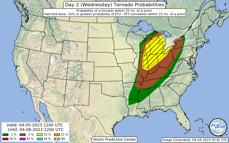
Huge 10% hatched in the latest D2 for Wednesday, including some seriously large population centers. Chicago and east could get very interesting from early on Wednesday.
-
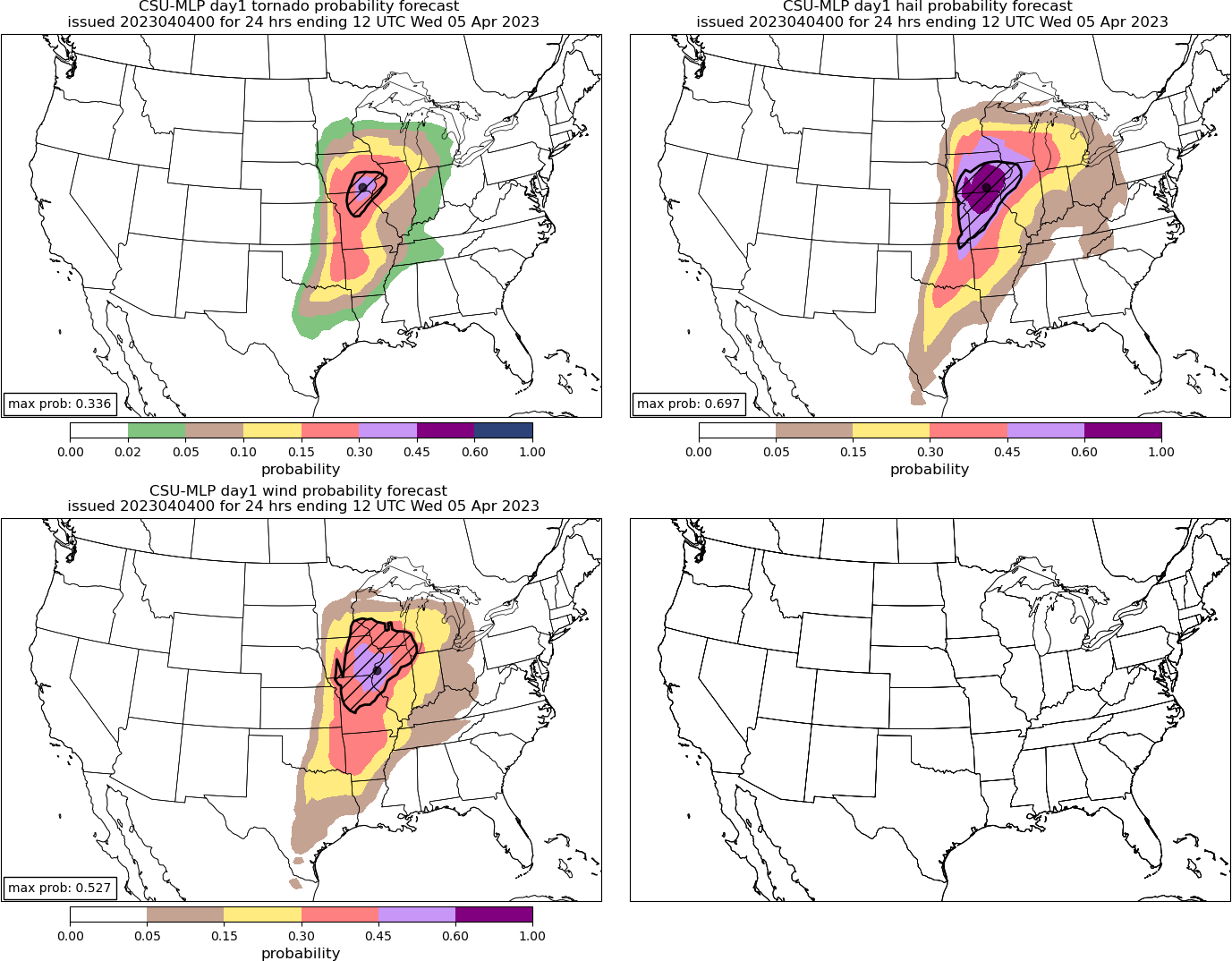
New CSU has a 30% hatched tornado area (high risk equivalent) for the IA/IL/MO triple point region tomorrow. Large 60% hatched hail and 45% hatched wind to accompany it centered on the same area.
-
NSSL WRF also with a monstrous cell tracking from NE MO into W IL in the afternoon. Environment around it is stupidly high end. Edit: ARW too.
-
Re: mixing tomorrow and resultant high LFCs and LCLs on the HRRR.
-
Remains a strong convective signal on the Euro roughly encompassing the current D2 MDT zone, in a highly favorable parameter space.
-
HRRR has problems with LCL heights early in MO, highlighting the concern with mixing (although it tends to be too aggressive with that).
-
Think this one is off timed for the Chicago area. Biggest threat is west on Tuesday, east on Wednesday.
-
That is classic for a significant Great Lakes severe event. Timing/destabilization pending of course.
-
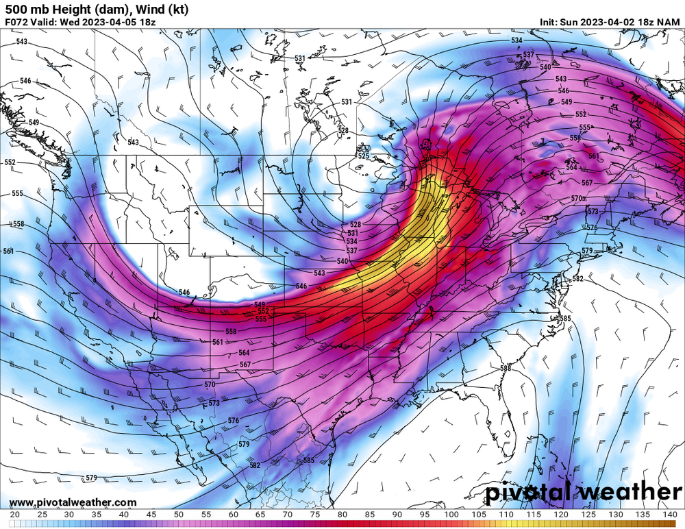
Wednesday has potential to be significant in the Lakes if there’s enough destabilization, 500 mb setup is consistent with some of the bigger early season events in the area.
-
2 additional fatalities in Owen Co. IN.
-
One limiting factor with this may be mixing if we get near the progged high temperatures from some of the models. LCL heights would be an issue.
-

2023 Mid-Atlantic Severe Wx Thread (General Discussion)
andyhb replied to Kmlwx's topic in Mid Atlantic
Reports out of Sussex Co. DE are not good.- 2,785 replies
-
- 3
-

-
- severe
- thunderstorms
- (and 3 more)
-
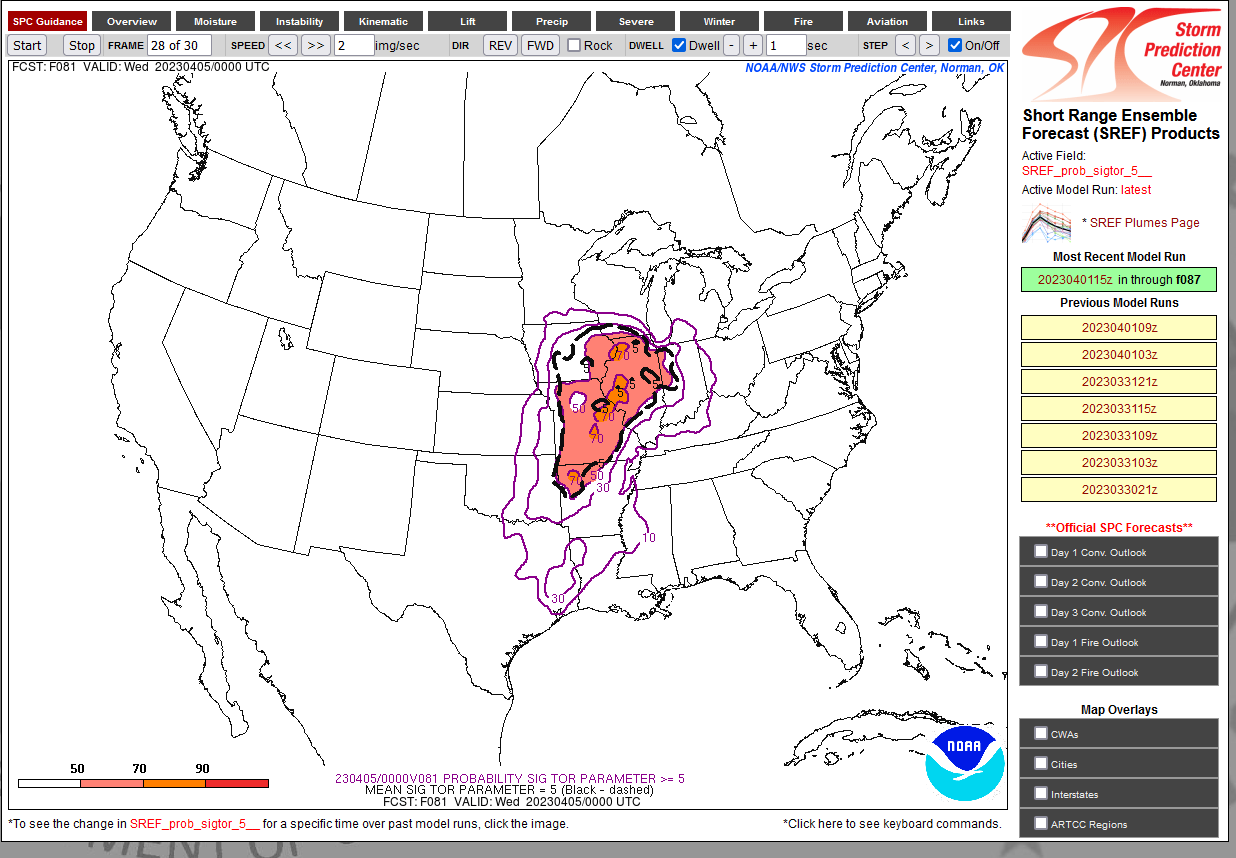
Amazingly high probabilities of STP ≥ 5 over a large area for Tuesday 81 hours out from the 15z SREF. Never seen anything like that at this range.

-
Strong tornado passing very close to the DOX radar right now.
-
HRRR is trying for Mullica Hill part II. Parameter space around that modeled cell is impressive if it does go.
-
That's at 03z and also I have strong doubt that it is going to be 66 degrees at that time given the magnitude of WAA with this trough. NAM tends to be cold biased.
-
Sullivan IN tornado prelim EF3, 155 mph per IND.