

Isotherm
-
Posts
7,930 -
Joined
-
Last visited
Content Type
Profiles
Blogs
Forums
American Weather
Media Demo
Store
Gallery
Everything posted by Isotherm
-
As you know, examination of one variable in a vacuum is typically complex given there are always/invariably numerous constructively and destructively interfering forcing agents. That said, all else being held equal, generally +EAMT events are a net positive as far as enhanced favorability for downstream z500 patterns in the E US. The overall momentum budget right now is one of near parity to slightly above neutral, so we do not have a situation akin to 2016 w/ extremely high momentum precluding all ridge formations upstream (note, even in Jan 2016's very high momentum, the PNA was positive). Furthermore, the subseasonal forcing [e.g., MJO incoherence] also argues against prolonged -PNA. The mean state forcing thus far has promoted a neutral to positive PNA (which I expected until Feb) with a positive EPO. I would err toward model guidance improving on the PNA as we move past the New Year. As to your other inquiry - the location of the daughter vortices post split (or vortex post displacement) would govern location of coldest anomalies, but there are also gradations of SSW events -- some which briefly reverse z10/60N zonal winds, and those (more rare) which destroy the vortex. The latter tend to be better at creating their own regimes for about a month, sometimes even 40-45 days. But yes, hypothetically, sufficiently robust AO/NAO domain blocking would be able to countermand a much less conducive Pacific. Right now, modelling depicts the blocking action center slightly too far south on the Atlantic side to countermand. I think you'll find some of these z500 depictions changing somewhat over the next several days. Model chaos is further heightened in times of significant vortex assault as well.
-
@frd, not sure if you have been reading my updates in my winter outlook thread, but my thoughts remain the same as those expressed there (and not much disparate then initially w/ January). January still appears to offer the most conducive wintry potential in the Northeast/Mid-Atlantic of the winter, in my view (my initial thoughts were normal to snowier than normal and slightly colder than normal - I don't see compelling reason to abandon this). Those thoughts were, and continue to be expressed irrespective of the outcome of any SSW technical event, a phenomenon which receives too much focus in my view. Speaking generally in the meteorological community, I think sometimes there is a propensity for expectations to be set too high, and when modelling doesn't accord with those overly heightened expectations, disappointment ensues (E.g., it was never wise to set the bar at "epic" January - while that outcome can happen - it's still somewhat low probability). The current contemporaneous wave-1 hit on the SPV + multiple robust Siberian high descents-->+EAMT--> jet extension should be more than sufficient to tilt the NAO/AO negative for much of January. As the initial jet extensions begin to relax post the medium range, I anticipate amelioration in the PNA domain beyond the 5th or so of January. The "good" news is that the troposphere has evidenced receptivity to stratospheric alterations this winter, meaning, coupling and feedback strat-trop is present, so even if a technical SSW occurs (again, not needed to reach my expectations for a decent January), it will tend to feedback and promote/maintain tropospheric blocking. Overall, I do not see substantial reason to panic from a winter enthusiast's perspective for the month of January in particular.
-
December 2020 General Discussions & Observations Thread
Isotherm replied to bluewave's topic in New York City Metro
Full snow cover maintained here through Christmas Eve. Will be gone later today, but a solid period for early winter (16th-24th). -
My Winter Outlook 2020-21
Isotherm replied to Isotherm's topic in Weather Forecasting and Discussion
@griteater, thanks for your reply. Regarding the evolution: the amount of momentum which ultimately will be added to the system via the torque processes should not be superfluous/overpowering to the extent that all semblance of +GP heights are extirpated in W North America. January 2016 is an exemplar of what one might consider the epitome of an extreme +AAM regime, complete with anomalously coherent GWO circuits. Even in that paradigm, the PNA domain was positive (actually, strongly so), and even the EPO neutral to slightly negative, w/ a GOAK trough immediately west of the W North American Coast. Of course the +ve momentum regime extant is much less anomalous, and the z500 is multifactorial, but it's an example of what can happen. I think modelling (e.g., EPS depiction for early January) should eventually morph into a depiction wherein we see positive geopotential heights in the PNA domain, and close to neutral or positive heights extending northward on the W Coast of North America. We should see the lower GP heights retrograde somewhat, but I'm not yet sold on a massive -EPO in conjunction with a +PNA/-NAO. My original thinking for January was +PNA/-NAO and EPO closer to neutral or pos., as preseason factors did not appear favorable for prolonged -EPO. One factor to aid the EPO heights, possibly, is stratospheric alterations - however - will need to monitor. So, in short, I think we'll see data back off somewhat on driving the Pacific jet through W NA, and eventually by early January, begin to see the +PNA reform with at least near neutral EPO. That pattern along with the Atlantic changes should be sufficient to make the pattern interesting for many. It's far out, but the end of the EPS seems to begin these changes to which I refer in the PNA domain. -
December 2020 General Discussions & Observations Thread
Isotherm replied to bluewave's topic in New York City Metro
Additionally (supplement to your good points here) regarding the United States "average" snowfall, left unsaid is whether that average is derived via a population weighted calculation. The raw average may be somewhat deceptive. A comparison of moderately-highly populated cities rather than an incorporation of all towns in the entire United States would likely yield NYC well above the 50th percentile. Locally, I've calculated a 31.0" average snowfall for 1990-2020. It's been an excellent 20 year period in interior Monmouth County. Like portions of central LI, here, we tend to benefit from late developing Miller Bs, further mesoscale enhancement from the Sandy Hook Bay on NELY flow during winter storms, and proximity to the Atlantic Ocean, but not close enough to materially lower the snowfall average. Hence Monmouth County features a fairly interesting climate, and frequently steep snowfall gradient NW-SE/NNW/SSE in numerous storms. There's about a 9-10" differential in average snowfall across the county; 30-31" in the N/W and close to 20-21" in Manasquan. (My website here: https://www.lightinthestorm.com/nj-snowfall ). Newark Airport also has a 31.1" 30-year running average 1990-2020 per latest data. My median 30-year snowfall is 29.0", which is not far from the mean, and it suggests the frequency of above and below normal snowfall winters aren't too dissimilar. Contrast to locations farther south (for example, DCA) wherein snowfall medians are quite a bit lower than means. Also, possibly axiomatic, but the average for a given place is deceptive in how that average arrives. Most of the Mid-west outside of the Lakes region derives those 25-35" averages via frequently low end snowfall events (as you know). I think the region 39N-41N on the eastern side of North America has some of the most significant and fascinating variability in winter-time weather. -
December 2020 General Discussions & Observations Thread
Isotherm replied to bluewave's topic in New York City Metro
My brief thoughts on the coming multi-week period (reposted in my outlook thread as well main board); rapidly increased favorability should initiate at the tail end of December. "The GFS based guidance is likely rushing the genesis/realization of the auspicious pattern; the ECMWF/EPS are more congruous with the physical drivers. z50 geopotential heights favor a positive NAO from now through circa Dec 28th; as the Canadian 'warming' occurs in the stratosphere and z50 restructures w/ a wave-2 paradigm, geopotential heights will begin to respond within a few days over the NAO domain, with diminution there in the final 1-2 days of December/beyond. The classical Siberian high descent initiates December 26th +/- a couple of days which will induce a +EAMT and jet extension event at the very end of December, and thus ameliorating the downstream Pacific/PNA/EPO domain pattern by the early days of January. Therefore, the December 28th-January 2nd period should feature expeditious amelioration of the hemispheric pattern, first, with improvement in the NAO domain at the very end of December, then, shortly followed by the Pacific. If there is a storm threat of significance in late December, it would likely favor the interior Northeast/New England, in my view, with a threat for I-95 beyond that time-frame (sometime in the first 10 days of January), but we'll see how it evolves." -
My Winter Outlook 2020-21
Isotherm replied to Isotherm's topic in Weather Forecasting and Discussion
The GFS based guidance is likely rushing the genesis/realization of the auspicious pattern; the ECMWF/EPS are more congruous with the physical drivers. z50 geopotential heights favor a positive NAO from now through circa Dec 28th; as the Canadian 'warming' occurs in the stratosphere and z50 restructures w/ a wave-2 paradigm, geopotential heights will begin to respond within a few days over the NAO domain, with diminution there in the final 1-2 days of December/beyond. The classical Siberian high descent initiates December 26th +/- a couple of days which will induce a +EAMT and jet extension event at the very end of December, and thus ameliorating the downstream Pacific/PNA/EPO domain pattern by the early days of January. Therefore, the December 28th-January 2nd period should feature expeditious amelioration of the hemispheric pattern, first, with improvement in the NAO domain at the very end of December, then, shortly followed by the Pacific. If there is a storm threat of significance in late December, it would likely favor the interior Northeast/New England, in my view, with a threat for I-95 beyond that time-frame (sometime in the first 10 days of January), but we'll see how it evolves. -
December 16-17, 2020 Storm Observations and Nowcast
Isotherm replied to wdrag's topic in New York City Metro
7.5" is my final total here, after this morning's additional accumulation.- 1,011 replies
-
- 1
-

-
- heavy snow
- sleet
- (and 4 more)
-
December 16-17, 2020 Storm Observations and Nowcast
Isotherm replied to wdrag's topic in New York City Metro
7.1" was my total here in Colts Neck, Monmouth County. Significant level storm - nice to see after a nearly 3 year snowfall drought. ...Monmouth County... Freehold 7.2 in 0930 PM 12/16 Public Colts Neck 7.1 in 1010 PM 12/16 Trained Spotter Holmdel 7.0 in 0900 PM 12/16 Trained Spotter Hazlet 6.5 in 1000 PM 12/16 Public 2 ENE Perrineville 6.3 in 0300 AM 12/17 Trained Spotter Freehold Twp 6.2 in 1015 PM 12/16 Trained Spotter Howell 6.1 in 0830 PM 12/16 Public Manalapan Twp 6.0 in 1000 PM 12/16 Trained Spotter 1 S Howell 6.0 in 0605 PM 12/16 Public Rumson 5.5 in 0830 PM 12/16 Public 1 N Eatontown 4.5 in 0910 PM 12/16 Trained Spotter Leonardo 4.0 in 0945 PM 12/16 Public Matawan 4.0 in 0920 PM 12/16 Amateur Radio Middletown 4.0 in 0824 PM 12/16 Public Tinton Falls 3.5 in 0847 PM 12/16 Public Long Branch 2.3 in 0900 PM 12/16 CO-OP Observer Cliffwood Beach 1.8 in 0600 PM 12/16 Trained Spotter Wall Twp 1.8 in 0529 PM 12/16 Broadcast Media Atlantic Highlands 1.2 in 0548 PM 12/16 Public Oakhurst 0.8 in 0650 PM 12/16 Trained Spotter ...Monmouth County... Freehold 7.2 in 0930 PM 12/16 Public Colts Neck 7.1 in 1010 PM 12/16 Trained Spotter Holmdel 7.0 in 0900 PM 12/16 Trained Spotter Hazlet 6.5 in 1000 PM 12/16 Public 2 ENE Perrineville 6.3 in 0300 AM 12/17 Trained Spotter Freehold Twp 6.2 in 1015 PM 12/16 Trained Spotter Howell 6.1 in 0830 PM 12/16 Public Manalapan Twp 6.0 in 1000 PM 12/16 Trained Spotter 1 S Howell 6.0 in 0605 PM 12/16 Public Rumson 5.5 in 0830 PM 12/16 Public 1 N Eatontown 4.5 in 0910 PM 12/16 Trained Spotter Leonardo 4.0 in 0945 PM 12/16 Public Matawan 4.0 in 0920 PM 12/16 Amateur Radio Middletown 4.0 in 0824 PM 12/16 Public Tinton Falls 3.5 in 0847 PM 12/16 Public Long Branch 2.3 in 0900 PM 12/16 CO-OP Observer Cliffwood Beach 1.8 in 0600 PM 12/16 Trained Spotter Wall Twp 1.8 in 0529 PM 12/16 Broadcast Media Atlantic Highlands 1.2 in 0548 PM 12/16 Public Oakhurst 0.8 in 0650 PM 12/16 Trained Spotter- 1,011 replies
-
- 3
-
-
- heavy snow
- sleet
- (and 4 more)
-
I also posted the following in my winter outlook thread: Brief update with some thoughts on the storm threat & overall winter outlook. The provenance of this week's storm threat for the Northeast corridor can be traced backward in time to the robust poleward and eastward transfer of angular momentum, which is large part mediated this fairly unique (given various background indicators) episode of high latitude blocking. Most of the diminution of negativity is focused in the AO domain space, but the NAO has turned negative and will remain there for a period. It is this poleward momentum deposit and associated +GP height/50-50 anomaly which will act to largely countermand a less than optimal Pacific regime. This projected storm represents the most auspicious precondition set-up in a few years for the Northeast coast. It is highly likely that Baltimore, Philadelphia, Boston and NYC will receive at least 5-6" of snowfall, possibly DCA as well. The heaviest axis of snow - location indeterminate - will likely feature 8-16" on average. The most accumulation will occur approximately 1.5 degrees W/N of the path of the z850 low, and slightly W/N of the path of the z700 low, as evidenced by optimal uplift/DGZ confluence. This zone may occur anywhere from the northern mid Atlantic coast to north of NYC, depending upon the z500 evolution. It's nigh impossible to ascertain this zone right now. However, more importantly, from my perspective, is the storm opportunity provides a quasi-indicator for forthcoming pattern relapses. December's temperature departures thus far are according with my winter outlook: generally warm nationwide with the core of the warmth in the W-C plains, and cooler in the SE US. The z500 of +EPO, neutral-positive PNA is also verifying. The December AO and potentially NAO will be more negative than expected (hence the larger storm threat this week). However, this episode provides insight to me, that tropospheric receptivity is heightened for another pulse(s) of momentum transfer, and increased favorability, for my target winter month in the Northeast (January). If anything, the events of this week suggest to me that my January ideas are on track (for NYC: slightly colder than normal, and snowier than normal). A technical SSW is unlikely this winter, but the SPV should be weaker than normal for early-mid January. My expectation is the NAO will neutralize beyond this week, along with the AO, as the SPV reconsolidates and momentum alters. Thereupon, the Pacific should reorganize into a more conducive structure again, by the end of December. Thereafter, there will be another decline opportunity in the NAO/AO in the month of January, potentially operating contemporaneously with a +PNA and even near neutral EPO. My thoughts remain the same for beyond January. However, this week's storm will increase the probability that NYC's seasonal snowfall ends in the upper portion of my range, assuming the winter pattern continues to proceed as I anticipate. My projection at this stage for snowfall this week is 6-12" for NYC, a significant snowstorm. Again, the heaviest axis will be a function of z700/z850 proximities.
- 3,762 replies
-
- 8
-
-

-
- heavy snow
- heavy rain
- (and 3 more)
-
My Winter Outlook 2020-21
Isotherm replied to Isotherm's topic in Weather Forecasting and Discussion
Brief update with some thoughts on the storm threat & overall winter outlook. The provenance of this week's storm threat for the Northeast corridor can be traced backward in time to the robust poleward and eastward transfer of angular momentum, which is large part mediated this fairly unique (given various background indicators) episode of high latitude blocking. Most of the diminution of negativity is focused in the AO domain space, but the NAO has turned negative and will remain there for a period. It is this poleward momentum deposit and associated +GP height/50-50 anomaly which will act to largely countermand a less than optimal Pacific regime. This projected storm represents the most auspicious precondition set-up in a few years for the Northeast coast. It is highly likely that Baltimore, Philadelphia, Boston and NYC will receive at least 5-6" of snowfall, possibly DCA as well. The heaviest axis of snow - location indeterminate - will likely feature 8-16" on average. The most accumulation will occur approximately 1.5 degrees W/N of the path of the z850 low, and slightly W/N of the path of the z700 low, as evidenced by optimal uplift/DGZ confluence. This zone may occur anywhere from the northern mid Atlantic coast to north of NYC, depending upon the z500 evolution. It's nigh impossible to ascertain this zone right now. However, more importantly, from my perspective, is the storm opportunity provides a quasi-indicator for forthcoming pattern relapses. December's temperature departures thus far are according with my winter outlook: generally warm nationwide with the core of the warmth in the W-C plains, and cooler in the SE US. The z500 of +EPO, neutral-positive PNA is also verifying. The December AO and potentially NAO will be more negative than expected (hence the larger storm threat this week). However, this episode provides insight to me, that tropospheric receptivity is heightened for another pulse(s) of momentum transfer, and increased favorability, for my target winter month in the Northeast (January). If anything, the events of this week suggest to me that my January ideas are on track (for NYC: slightly colder than normal, and snowier than normal). A technical SSW is unlikely this winter, but the SPV should be weaker than normal for early-mid January. My expectation is the NAO will neutralize beyond this week, along with the AO, as the SPV reconsolidates and momentum alters. Thereupon, the Pacific should reorganize into a more conducive structure again, by the end of December. Thereafter, there will be another decline opportunity in the NAO/AO in the month of January, potentially operating contemporaneously with a +PNA and even near neutral EPO. My thoughts remain the same for beyond January. However, this week's storm will increase the probability that NYC's seasonal snowfall ends in the upper portion of my range, assuming the winter pattern continues to proceed as I anticipate. My projection at this stage for snowfall this week is 6-12" for NYC, a significant snowstorm. Again, the heaviest axis will be a function of z700/z850 proximities. -
My Winter Outlook 2020-21
Isotherm replied to Isotherm's topic in Weather Forecasting and Discussion
Thanks all for the comments. Ray - I just posted a full response to your above comments on your thread. Weather53, I have not seen either of their forecasts yet, though I think I read CWG was coming out with their outlook this week (or soon). Michigan - I think you're correct on that. I anticipate a fairly cold picture across Canada this year, not atypical for strong La Ninas, and so, any spasmodic perturbations w/ short wave trough slipping through the Lakes/Northeast could ephemerally plunge temperatures to very low values, before rising again. I especially anticipate this volatility later in December and January. -
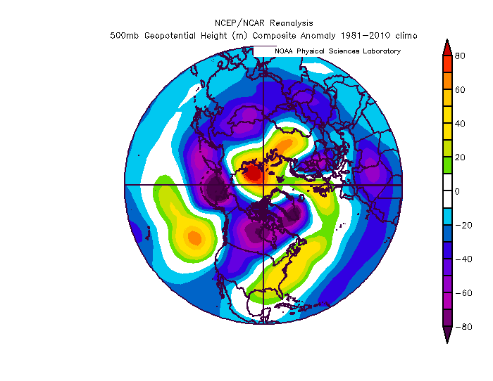
Ray - saw your comment on my thread. Just had a read of your forecast - great work and write up as per usual; well reasoned. As you noted, we are essentially harmonious on the bigger picture and overall season, but mostly differ on timing. I had initially thought early winter/Dec would be favored about a month ago, but as some of the mid autumn data emerged, it drove me toward the January-focused potential more and more. Re March, agree, lower confidence expressed here, though at this juncture I think it will be fairly hostile for the Eastern US. Here's my analogs z500 composite for March, if you're interested. Will be fascinating to see how this winter evolves, and certainly from a more local perspective, whether we can exceed snowfall totals of the past two winter seasons.
-
My winter outlook has been posted on the main board, which links to it, for those interested:
-
My winter outlook has been posted on the main board, which links to it, for those interested:
-
My winter outlook has been posted on the main board, which links to it, for those interested:
-
My winter outlook for the 2020-21 season can be read on my website, linked here, for those interested: https://www.lightinthestorm.com/
-
@frd -- I posted updated thoughts in the main board and NYC forum which may be of interest re your inquiry. Pre-season, I highlighted the fact that the westerly shear stress in the stratosphere/z30 would be obdurate [i.e., weakly positive QBO remains presently], and when coupled w/ suppressed solar backdrop and other proxies, actually favors a very stable vortex. In fact, that particular permutation most favors the stable vortex. Usually, disruptions don't occur until late winter. That, in concert with other variables accounted for in my NAO formula, indicated generally low-gepotential heights across the NAO/Arctic domain for this winter. In my update post here, I discuss the remainder of the winter. I think most of February will probably be +NAO, but the window for NAO blocking would initiate late Feb-March if it does this particular year:
-
Thank you, @griteater. Will be interesting to see the evolution of the rest of the winter. Not over yet, but so far, things have/are going generally per my expectations.
-
@frd, thanks for your comments. Yes, I think the probability remains lower than normal for a SSW this season, although, if there is one, the most likely window would be February. Later winter SSW events are more prevalent in low solar/+QBO backdrop. The tropospheric structure for the next few weeks is largely unfavorable for potent wave driving/trop-strat energy transfer. However, it's possible we might be able to achieve more auspicious torque forcing and momentum uptick later in January via tropical engagement. Nonetheless, even if a SSW were to occur, that doesn't guarantee surface impacts as you know.
-
Hi, @psuhoffman -- regarding your inquiry. The modality of the AAM, as in, positive or negative, is not most integral - but rather - the distribution and transport of angular momentum through the hemispheres. My analyses pre-season indicated unpropitious transports, that would likely countermand the development and maintenance of significant/sustained high latitude blocking structures for much of the winter season. There's more to the entire methodology as well, so, what is stated in the outlook is only a skeleton of what I've analyzed. But, as said, the AAM distribution in concert with other variables, such as QBO timing/diminution, Hadley, Walker Cell behavior, among other factors, were all utilized. We'll see how the rest of the winter progresses. However, the present model/NWP trending in recent days largely comports with my expectations.
-
2019 ENSO
Isotherm replied to AfewUniversesBelowNormal's topic in Weather Forecasting and Discussion
A strict construction of the ENSO-oceanic analysis may reveal neutral tending toward weak nino, but inclusion of the GSDM into the analysis yields a different conclusion. The total sum of momentum additions/subtractions evinces an apparent deficit/easterly momentum dominating the tropical/sub-tropical domains, and as such, retrogressive features will be the mainstay of the short to medium term. Whether the GWO neutralizes, thereby comporting more with the oceanic appearance remains to be seen. -
March 12/13/14 Blizzard/Winter Storm/WWA etc
Isotherm replied to Bostonseminole's topic in New England
@IrishRob17 @40/70 Benchmark, That is correct, I am not advocating for the once per day observation -- which is much different than capturing the maximum snowfall for the 24 hour period. Ray, to be clear, I am merely presenting the guidelines as they currently stand, which states that non-airport measuring should be maximum snowfall for the 24 hour period. I am not advocating that the 6-hr clearing is necessarily a bad method. I just think congruence with historical records is important and we never should have added the option for 6hr clearing in the 1998-2012 period. Per my discussion with Matt who works with the NJ climatologist, there was extensive debate among the people on the panel for this 6hr - maximum snowfall issues. Interestingly enough, the person who pushed most for the 6-hr method was the same person who reversed his thinking and signed off on the return to the maximum snowfall method. Snow measuring is an inexact science; there are arguments for both methods. -
March 12/13/14 Blizzard/Winter Storm/WWA etc
Isotherm replied to Bostonseminole's topic in New England
I concur with this too, I think they should have maintained the maximum depth standard. -
March 12/13/14 Blizzard/Winter Storm/WWA etc
Isotherm replied to Bostonseminole's topic in New England
Agree, and I'd argue the once per day observation is the least accurate of all for sure. The clearing/vs maximum depth should be fairly similar in most storms that aren't > 32F at the surface.
