

Isotherm
-
Posts
7,930 -
Joined
-
Last visited
Content Type
Profiles
Blogs
Forums
American Weather
Media Demo
Store
Gallery
Everything posted by Isotherm
-
Regarding the seasonal prognostication discourse, as someone who has been engaging in biannual long range outlooks (summer, winter) since 2006-07, with a high degree of success, I would state that the outcome which occurred this winter as it pertains to the AO domain in particular, (to a lesser extent the NAO), is very rare statistically speaking, wrt the indicators I analyze. The type of atmospheric alteration which occurred Nov-Dec and at the magnitude at which it occurred, was a nigh impossibility when considering the 1950-2020 indicator data. I expected the PNA+ outcome (Dec/Jan +, Feb -) and EPO+, and thought the NAO would go + Dec, - Jan, +Feb (but the DJF will be negative, a miss), and the AO severely negative was a major derogation from expectations. My formula that I utilize which incorporates several disparate variables and prognosticates the NAO at circa 90% success did not foresee this, thus, this AO-NAO outcome to me was a true curveball in the sense that the indicators actually supported an opposite average DJF outcome for the modality of the NAO-AO. I've determined upon analysis that the salient variables which emerged, in my view at least, could have only been potentially foreseen if I had waited another 10 days or so to write my winter outlook. There were red flags I noticed later in November that suggested the AO may not be positive for the winter. Overall, a very fascinating winter from the standpoint of atmospheric and oceanic nina-esque and nino-esque imprints. The SSW was a wildcard which disturbed the timing of the temperature progression, although the winter will average warmer than normal as I thought. I would hypothesize that a displacement outcome rather than a split may have allowed the colder January I thought would occur, but we ended up with a split, and a rather benign pattern for our -NAO month in January. The major stratospheric warming event was another highly unusual outcome given certain precursor signals, but the indicators did favor a perturbed and weak tropospheric vortex for January.
-
OBS and nowcast Thursday morning 2/18 - 11PM Friday 2/19/21
Isotherm replied to wdrag's topic in New York City Metro
Indeed, it was. The stratospheric warming wildcard was fascinating, as if that evolved more-so in a displacement rather than split fashion, January likely would have been colder. Retrospectively, the NAO will be near neutral December, negative January, and positive February. But the SSW prevented us from receiving the cold/snow results until later. I thought we'd have most of our snow this winter within a month stretch, but was off on the timing by about 15 days. The magnitude of the snowy period was more impressive than anticipated due to the -AO/blocking this winter. -
OBS and nowcast Thursday morning 2/18 - 11PM Friday 2/19/21
Isotherm replied to wdrag's topic in New York City Metro
Thanks and almost - this event brings me to 38.9" on the season (31.1" since Jan 31st). Today was certainly the definition of a CNJ/Monmouth jackpot. It appears C-NJ/N-NJ, at least through today, has been one of the most favored regions snowfall wise relative to normal, in the DCA-BOS corridor. Our stretch of snow cover was 8 days in December, and Jan 31st-present thus far. -
OBS and nowcast Thursday morning 2/18 - 11PM Friday 2/19/21
Isotherm replied to wdrag's topic in New York City Metro
9.8" now total here. -
OBS and nowcast Thursday morning 2/18 - 11PM Friday 2/19/21
Isotherm replied to wdrag's topic in New York City Metro
8.8" here, likely final total - Colts Neck, Monmouth County [reported to NWS via trained spotter ID]. This brings us to 37.9" on the season. -
OBS and nowcast Thursday morning 2/18 - 11PM Friday 2/19/21
Isotherm replied to wdrag's topic in New York City Metro
6.5" here so far - interior Monmouth. -
Currently 12.2F with ground ice fog here -- a unique, rare phenomenon, induced by the deep, fresh snow cover. It was "freezing fog", but note that typically under 14F it is termed "ice fog" as the water droplets cannot remain in liquid forum.
-
Obs and nowcast Super Bowl Sunday 4A-6P Feb 7, 2021
Isotherm replied to wdrag's topic in New York City Metro
5.1" total. 27.1" YTD. Current depth: 11". -
My Winter Outlook 2020-21
Isotherm replied to Isotherm's topic in Weather Forecasting and Discussion
One note on snowfall: Snowfall is invariably the most stochastic, capricious and therefore most difficult variable to prognosticate from the long range, which is why I assign more weighting to temperature departures than snowfall at final verification. That said, the snowfall tally through 2/5/2021 has NYC at 28.0", slightly above my seasonal snowfall range. It is almost certain that this value will be increased, via, at least, light or moderate opportunities in the coming 10 days. Boston, currently around 22", has a ways to go to arrive at my range of 40-48", though that is still within the range of outcomes, certainly. The Mid-Atlantic cities are nearing my seasonal projections at this time. We will see how the remainder of this period progresses. However, for those certainly in the NYC area, it appears certain that a "positive" snowfall error will be occurring this winter, namely, more snowfall than forecasted. NYC will likely get into the 30s as far as snowfall. The evolution of the mid-month threat is subject to a number of different permutations and mechanisms. The equatorward/southwestward degradation of the block toward the Pacific is not ideal, as it could invite height rises in the Southeast US. Further to that, the MJO is somewhat out of phase and may tend to force SE-ridge resistance in the means. Contemporaneously the TPV will press from the north, as the SSW mediated block decays to its northwest. Overall, a highly convoluted and difficult to prognosticate variables. However, the rapid multi-standard deviation rise in the AO & NAO invite another large precipitation event opportunity. The PNA may not be as conducive this window, however, and that must be monitored. I'm not nearly as optimistic about this window as I was for Jan 31-Feb 2 along the Northeast/Mid-Atlantic coast, due in part to the more favorable mechanics of the block degradation in Jan 31-Feb 2. That said, Feb 12-14 is a window to monitor in the East. -
My Winter Outlook 2020-21
Isotherm replied to Isotherm's topic in Weather Forecasting and Discussion
Indeed. While there is significant uncertainty as to the pace at which the NAO neutralizes in the medium to long range, I believe it's high probability as this point that DJF will average negative for NAO (barring an anomalous positive episode from mid month through the end of Feb, which isn't out of the question). The NAO finished -1.11 for January and -0.3 for December. January was expected, but the inter-monthly duration of the NAO was unexpected. The DJF NAO miss will go down as my first NAO formula miss in about a decade. And of course the AO domain, likely the most glaring aberration from the indicators I've quite frankly ever seen. The QBO finished +10 for January, continued strongly westerly. And while that in and of itself is not the sole determinant, there were other robust indicators pre-season that strongly suggested a neutral or positive AO mean winter. I have been speculating/hypothesizing as to provenance -- the 2020 Australian fire induced aerosol dispersal may have been a factor in changing things up, possibly in concert with record low Arctic sea ice. But I think more likely the former. Regardless, the mean circulation flow altered significantly in the Arctic once December began. As to February temperature departures, as you delineated in a recent post, it is possible the East Coast still finishes warmer than normal, depending upon the second half. The core of the cold will clearly be centered in the N Rockies-N Plains for the first half of the month. Overall forecasted temperature departures DJF still may fare very well; we will revisit that at the end of Feb. Snowfall -- New England looking good for a SWFE threat next week (potentially). And we'll need to monitor the window around mid-month as the blocking structure degrades. -
13.8" total here, likely total. An additional 1.7" fell overnight/this morning. Year to date seasonal is 21.3".
-
12.1" here now. Solid low-end MECS territory, if it were to be over. I thought we would receive 14-18" total (that band clearly developed 15 miles farther north, favoring N/C NJ into NYC). However, it is possible we pick up an additional 1-3".
-
A major winter-storm is evolving across the Mid-Atlantic and Northeast, as signaled by the macro-scale proxies which suggest that a meteorological show will be displayed over the coming 12-36 hours. The appearance of this storm as much as two weeks ago was foreshadowed by the multi-standard deviation height field alterations over key domain spaces (specifically the PNA/NAO vicissitudes). As a result, this will likely be the largest, widespread winter storm since March 2018. Estimated snowfall for various locations: Atlantic City, NJ: < 2" Point Pleasant, NJ: 5-10" Trenton, NJ: 14-18" Freehold: 14-18" - locally higher New Brunswick: 14-18" - locally higher New York City, NY: 14-18" - locally higher Newark, NJ: 14-18" - locally higher Philadelphia, PA: 6-12" Sussex, NJ: 8-15" "Jackpot" totals will occur via the juxtaposition of initial overrunning, maintenance of frozen p-type during the energy transfer, and the secondary redevelopment induced enhancement. This region will be approximately 1.5 degrees latitude north of the z850 low path, and N/W of the z700 low path -- NYC on the northeastern side, Morristown on the northern side, southwestward to near the Delaware River, then extending southeastward to Freehold on the southeastern side. I expect that there will likely be some 18"+ reports within the delineated zone.
- 2,424 replies
-
- 9
-

-

-
- heavy snow
- ice pellets
- (and 3 more)
-
My Winter Outlook 2020-21
Isotherm replied to Isotherm's topic in Weather Forecasting and Discussion
Monitoring the recovery of the z10-z50 stratospheric vortices as well as the subseasonal/MJO signal which will play a greater role in the month of February. At least, from the NAO perspective, it will flip positive early Feb (following the major storm/phase change threat, which finally showed up at the tail end of the Jan +PNA/-NAO pattern). Then the NAO may dip negative again in the Feb 5-9 time frame, but potentially only ephemerally. Coherent MJO 6-7 w/ magnitude is a +NAO signal, and depending upon the pace at which the SPV recovers, that may add adjunctively to a neutral or + NAO. The AO domain, I think may be a bit different, and that domain space will clearly go down as a miss this winter. The AO will probably average neutral to negative for Feb, if only by virtue of both residual +GP strat heights initially, but then the coherent MJO 6-7 assist will drive poleward EPO ridging into the Arctic domain. So the AO heights will receive assist from the Pacific induced intraseasonal alterations. My thinking at this time is the MJO expeditiously weakens in coherency beyond P7, so most of Feb should still feature the fairly robust SE-ridging in the means, and a colder Rockies/N Plains structure as forecasted. Another player on the field is that Feb will have legitimate arctic cold on the North American side, now that the SSW is over. So the cold shots that do slide through the Northeast US will be quite strong in February. Fascinating winter overall, and from a LR forecasting point of view, particularly on the AO domain, a very rare outcome in terms of opposing certain indicators. I still think February will probably be a snowier than normal month for most of New England (although warmer than normal in the means). SNE coast points southward will be dependent upon the extent of countervailing blocking. -
The macro-scale physical forcing agents are conducive. After most of January +PNA/-NAO in the means and a few missed opportunities, favorability tends to reach a point of culmination during significant mass height field vicissitudes, e.g., as evidenced by the rapidly neutralizing NAO and PNA near the end of January. Meteorology being a probabilistically driven field, it always made/makes sense to emphasize that probabilities were/are heightened for snowfalls, but a deterministic guarantee that significant snowfall will occur is often imprudent beyond short range. Nonetheless, these lengthy wait times in conducive regimes are not uncommon (e.g., December 2010 wait time until very late month, near phase change). Here, we see the canonical jet retraction to off-west coast trough adjunctively with the decaying Hudson block/departing confluence, and amplifying Rockies longitude geopotential height rises. This should certainly yield a cyclogenesis event along the East Coast. The finer mesoscale details will be disambiguated, as everyone knows, in the coming days. But an energy transfer-primary-secondary appears fairly likely, with the potential for a z500 close off if the energies phase correctly. It's a legitimate threat within a legitimate, bonafide pattern, in fact the threat with the highest potential of success so far this January (verbatim, now, Jan 31-Feb 1). This still can imply a failure; that is certainly on the table. However, the macro-scale features in their phase changing capacities will almost guarantee an intensifying low on the coast, it's merely a matter of which region receives the brunt (on the east coast).
- 2,424 replies
-
- 12
-
-
-
- heavy snow
- ice pellets
- (and 3 more)
-
My Winter Outlook 2020-21
Isotherm replied to Isotherm's topic in Weather Forecasting and Discussion
Often used synonymously with the AO; Northern Annular Mode, a proxy which has geospatial overlap to the AO. I think we will flip to a +AO/NAO. https://energyeducation.ca/encyclopedia/Northern_Annular_Mode#:~:text=Northern Annular Mode (NAM) also,the shape is more annular. -
My Winter Outlook 2020-21
Isotherm replied to Isotherm's topic in Weather Forecasting and Discussion
Ray, Not yet. Historically and probabilistically, from the standpoint of the background conditions/forcing agents extant at this time (e.g., one variable being the QBO), almost always yield a robust reversal of the NAM status in month 3 (we will now have seen two consecutive months, Dec-Jan, of fairly strongly negative AO status). From a forcing perspective, the putative rubber band snap typically (much more often than not) occurs when the winter-night is still lengthy, as it remains in late January, auspicious for re-intensification (as opposed to a late Feb or beyond SSW event, which is a more energy intensive process to regain potent vortex status). Further, the tropospheric pattern, unlike earlier in the winter, does not appear conducive for major wave driving/energy transfer into the stratosphere beyond the end of the month. So while there may be some plateauing at the end of January sufficient to hold vestiges of blocking into the early part of February, I still tend toward the idea that the direction we're headed is towards a +NAM state. The temperature departures of significant warmth in the East may be slightly more in question, if early month can include much more countervailing cold presses. But we'll see how it evolves. -
My Winter Outlook 2020-21
Isotherm replied to Isotherm's topic in Weather Forecasting and Discussion
Ray, indeed and I hear you re the internal conflict going forward. Certainly after the past few benign winters, it would be nice to have a longer wintry period. February's more canonical Nina z500 structure should tend to favor the northern and potentially even central New England at times for snowfall. So I don't think your area has as much concern to maximize the upcoming 2-3 weeks of potential (though the coming period should offer best opportunities). -
My Winter Outlook 2020-21
Isotherm replied to Isotherm's topic in Weather Forecasting and Discussion
@40/70 Benchmark, the definition of sudden stratospheric warmings has been elusive, subjective and often capricious throughout the decades (see this paper, at least 9 different definitions): https://www.arl.noaa.gov/documents/JournalPDFs/Butler_et_al_2015_bams-d-13-00173.1.pdf You are correct that the common WMO definition of 'major' will be reached [mean zonal wind reversal to easterly at 10 hpa / 60N]. Other definitions, one of which I prefer for major ascertainment, is 60N/10hpa mean zonal wind reversal to easterly for a minimum of 5 consecutive days (see Simon Lee's blog: https://simonleewx.com/2019/01/24/the-january-2009-ssw/). I've been monitoring this event, and it seems we may have an interruption in the zonal wind reversal in the coming 1-2 days [see ECMWF below]: [note that the 10 hpa/60N zonal wind will probably hit or exceed 0 in the coming 48 hours, before slipping back easterly again]. https://users.met.fu-berlin.de/~Aktuell/strat-www/wdiag/ts.php?plot=fluxes&alert=1&lng=eng&hem=nh So, we'll have to watch that interruption. But regardless, the technical, subjective definitions don't matter much to me, as what is more integral is the tropospheric receptivity, downwelling potential, and resultant tropospheric response. The existing z30 westerly stress from the +QBO will tend to promote a more robust post-SSW recovery in my view, as well. @LibertyBell, I believe there's high probability of NYC finishing in the upper portion of my snowfall range (low/mid 20s) with some potential for higher/toward average, depending upon the outcomes of the next few weeks (which I think provide the best opportunities for snowfall). In March, wavelengths are much shorter, and thus typically unfavorable winter patterns can become more serviceable - so I wouldn't be surprised if we had an event in March. I would still lean toward around 30" total or lower for the seasonal total. We shall see how it evolves.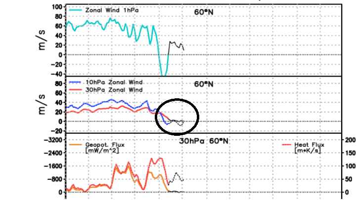
-
My Winter Outlook 2020-21
Isotherm replied to Isotherm's topic in Weather Forecasting and Discussion
Mid-Winter Checkpoint: December = Thus far, the winter is progressing mostly in accordance with expectations. December finished +1.7 in NYC (within the range provided for in the outlook, +1.5 to +2.5). Most of the Northeast/Mid-Atlantic finished similarly. The core of warmth centered over the Rockies/NW Plains as anticipated, with a cool zone near Florida. The +PNA verified as expected, along with the +EPO. The NAO for December was merely slightly negative. The principal error was the AO domain, which finished -1.7 (negative); this aided in permitting the significant snowfall for the NE corridor. January = the forecasted mean +PNA/-NAO looks to verify. I see no reason to depart from the temp. anomalies forecasted. The highest probability for medium+ impact events of the winter exists in the coming multi-week period. The occurrence of the SSW is immaterial to the overall forecast, and a byproduct of the antecedent tropospheric forcing. This will likely be a significant, not major, SSW, and a non-vortex destruction event. This, too, has implications. The EPO may briefly move negative in the latter part of the month. The most conducive period for the SE US/Mid-Atlantic will likely be 12th-20th. Beyond the 20th, more resistance should develop in the far SE US via PNA diminution, implying the target zone may shift northward along the East Coast. The details are indeterminate and will be predicated upon wave/timing/propagation. Therefore, January 10th-31st should provide for greatly enhanced probabilities of wintry weather. February = I expect a rapid disintegration of the coming multi-week pattern, with the genesis of +NAO/AO in concert w/ -PNA/Nina-esque Pacific structure. The delay of any negative PNA phase until February was/still is expected from my standpoint. It's possible the PNA may beginning transitioning as early as very late January. Sub-seasonal forcing should constructive interfere w/ low frequency forcing near the Maritime Continent, retracting the jet and forcing a more canonical Aleutian High/NW US trough paradigm. The stratospheric vortex should expeditiously redevelop to at least near average intensities by early February, and subsequently couple rapidly. Thus, I continue to think February will favor locations further north [N/C New England] for meaningful snowfall. -
December 2020 General Discussions & Observations Thread
Isotherm replied to bluewave's topic in New York City Metro
Full snow cover maintained here through Christmas Eve. Will be gone later today, but a solid period for early winter (16th-24th). -
My Winter Outlook 2020-21
Isotherm replied to Isotherm's topic in Weather Forecasting and Discussion
@griteater, thanks for your reply. Regarding the evolution: the amount of momentum which ultimately will be added to the system via the torque processes should not be superfluous/overpowering to the extent that all semblance of +GP heights are extirpated in W North America. January 2016 is an exemplar of what one might consider the epitome of an extreme +AAM regime, complete with anomalously coherent GWO circuits. Even in that paradigm, the PNA domain was positive (actually, strongly so), and even the EPO neutral to slightly negative, w/ a GOAK trough immediately west of the W North American Coast. Of course the +ve momentum regime extant is much less anomalous, and the z500 is multifactorial, but it's an example of what can happen. I think modelling (e.g., EPS depiction for early January) should eventually morph into a depiction wherein we see positive geopotential heights in the PNA domain, and close to neutral or positive heights extending northward on the W Coast of North America. We should see the lower GP heights retrograde somewhat, but I'm not yet sold on a massive -EPO in conjunction with a +PNA/-NAO. My original thinking for January was +PNA/-NAO and EPO closer to neutral or pos., as preseason factors did not appear favorable for prolonged -EPO. One factor to aid the EPO heights, possibly, is stratospheric alterations - however - will need to monitor. So, in short, I think we'll see data back off somewhat on driving the Pacific jet through W NA, and eventually by early January, begin to see the +PNA reform with at least near neutral EPO. That pattern along with the Atlantic changes should be sufficient to make the pattern interesting for many. It's far out, but the end of the EPS seems to begin these changes to which I refer in the PNA domain. -
December 2020 General Discussions & Observations Thread
Isotherm replied to bluewave's topic in New York City Metro
Additionally (supplement to your good points here) regarding the United States "average" snowfall, left unsaid is whether that average is derived via a population weighted calculation. The raw average may be somewhat deceptive. A comparison of moderately-highly populated cities rather than an incorporation of all towns in the entire United States would likely yield NYC well above the 50th percentile. Locally, I've calculated a 31.0" average snowfall for 1990-2020. It's been an excellent 20 year period in interior Monmouth County. Like portions of central LI, here, we tend to benefit from late developing Miller Bs, further mesoscale enhancement from the Sandy Hook Bay on NELY flow during winter storms, and proximity to the Atlantic Ocean, but not close enough to materially lower the snowfall average. Hence Monmouth County features a fairly interesting climate, and frequently steep snowfall gradient NW-SE/NNW/SSE in numerous storms. There's about a 9-10" differential in average snowfall across the county; 30-31" in the N/W and close to 20-21" in Manasquan. (My website here: https://www.lightinthestorm.com/nj-snowfall ). Newark Airport also has a 31.1" 30-year running average 1990-2020 per latest data. My median 30-year snowfall is 29.0", which is not far from the mean, and it suggests the frequency of above and below normal snowfall winters aren't too dissimilar. Contrast to locations farther south (for example, DCA) wherein snowfall medians are quite a bit lower than means. Also, possibly axiomatic, but the average for a given place is deceptive in how that average arrives. Most of the Mid-west outside of the Lakes region derives those 25-35" averages via frequently low end snowfall events (as you know). I think the region 39N-41N on the eastern side of North America has some of the most significant and fascinating variability in winter-time weather. -
December 2020 General Discussions & Observations Thread
Isotherm replied to bluewave's topic in New York City Metro
My brief thoughts on the coming multi-week period (reposted in my outlook thread as well main board); rapidly increased favorability should initiate at the tail end of December. "The GFS based guidance is likely rushing the genesis/realization of the auspicious pattern; the ECMWF/EPS are more congruous with the physical drivers. z50 geopotential heights favor a positive NAO from now through circa Dec 28th; as the Canadian 'warming' occurs in the stratosphere and z50 restructures w/ a wave-2 paradigm, geopotential heights will begin to respond within a few days over the NAO domain, with diminution there in the final 1-2 days of December/beyond. The classical Siberian high descent initiates December 26th +/- a couple of days which will induce a +EAMT and jet extension event at the very end of December, and thus ameliorating the downstream Pacific/PNA/EPO domain pattern by the early days of January. Therefore, the December 28th-January 2nd period should feature expeditious amelioration of the hemispheric pattern, first, with improvement in the NAO domain at the very end of December, then, shortly followed by the Pacific. If there is a storm threat of significance in late December, it would likely favor the interior Northeast/New England, in my view, with a threat for I-95 beyond that time-frame (sometime in the first 10 days of January), but we'll see how it evolves."