weathermedic
-
Posts
2,235 -
Joined
-
Last visited
Content Type
Profiles
Blogs
Forums
American Weather
Media Demo
Store
Gallery
Everything posted by weathermedic
-
89 DP 75 HI 100 at my station. Touched 90 degrees a little while ago. South wind off the ocean will probably drop a couple more degrees in the afternoon unless wind becomes more SW-W.
-
77/73 at my station
-
Squeezed out .29 from the activity yesterday at my station.
-
Watches up for most of NJ
-
88 degrees with a dew point of 3 in Las Vegas right now...just saying
-
1.25 inches from that deluge here at my station
-
4.57 inch/hr rate here. Picked up a half inch in less than 10 minutes
-
82/74 in Sheepshead Bay
-
Made it up to 93 at my station yesterday in Sheepshead Bay before the wind shift to the south
-
Much of north-central NJ under a severe t-strom warning
-
Showers starting to pop up over lower Manhattan, Staten Island and northeast Queens ahead of the main show in western NJ
-
Area increasing in coverage and approaching the PA/NJ border
-
Looks like some action starting to develop across central PA
-
The Storm Prediction Center has placed most of our region in a Marginal Risk for Severe weather today. The main threat with any thunderstorms will be strong winds and heavy rainfall. Expect the best timing for storms to be this afternoon and early this evening.
-
The Storm Prediction Center has placed most of our region in a Marginal Risk for Severe weather today. The main threat with any thunderstorms will be strong winds and heavy rainfall. Expect the best timing for storms to be this afternoon and early this evening.
-
Day 2 Convective Outlook NWS Storm Prediction Center Norman OK 1220 PM CDT Wed Jun 02 2021 Valid 031200Z - 041200Z ...THERE IS A SLIGHT RISK OF SEVERE THUNDERSTORMS PORTIONS OF THE MID-ATLANTIC... ...SUMMARY... Strong to severe storms are possible over a portion of the Middle Atlantic Thursday with locally strong to damaging gusts the primary threat. Other strong to severe storms with locally strong to damaging wind gusts will be possible over a portion of the Tennessee and Ohio Valleys as well as eastern Oregon. ...Synopsis... A shortwave trough will move from portions of the Mid-South into the Mid-Atlantic on Thursday. A weak frontal boundary will push through the Ohio Valley into the Appalachians. Ahead of the boundary, moisture return is expected to continue through the day into the Mid-Atlantic and parts of the Northeast. In the Pacific Northwest into the northern Rockies, a shortwave trough will impact the region by late afternoon into the evening. ...Mid-Atlantic... Widely-scattered to scattered convection is expected to develop both ahead of the weak boundary and within areas of pre-frontal confluence from northern Virginia into southeastern New York. There remain uncertainties as to where the greatest boundary layer destabilization will occur given cloud cover within the warm conveyor belt as well as warm advection precipitation in North Carolina/southern Virginia. Forecast soundings indicate a greater potential for cloud breaks from northern Virginia into southeastern New York. This area will also see a modest increase in 850 mb flow by afternoon/evening which will increase the threat for damaging gusts and perhaps an isolated tornado. Father north into eastern New York/Vermont, there is less certainty on the degree of destabilization, but relatively strong mid-level forcing should promote scattered storms with some attendant threat for wind damage. Mid-level lapse rates will not be overly steep, but where greater buoyancy develops isolated large hail will be possible.
-
Finished up with 2.71 inches total rainfall at my station in Sheepshead Bay for the weekend event.
-
Looks like most of the rain to our south on radar will stay over the ocean. Long Island should get hit with more rain than areas west of there.
-
1.44 at my station so far. More on the doorstep moving up from the southwest.
-
Tide up over Brookville Blvd behind JFK as usual with these persistent easterly fetch situations. PD shut down that stretch of Brookville Blvd. At least one car stuck in the water.
-
Sea breeze extending pretty far inland in NJ on radar. Wonder if this will enhance the storms as they head east through NJ
-
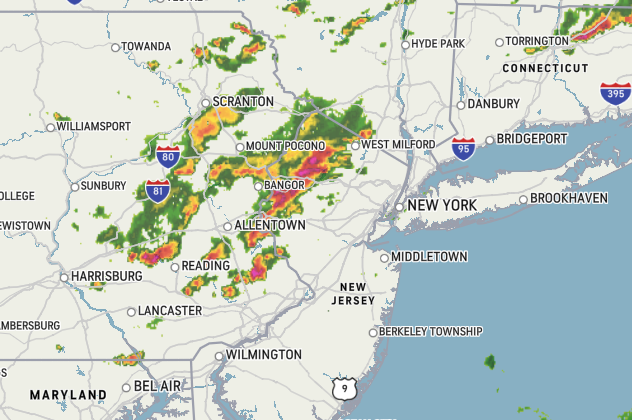
Nice line of storms forming in central PA with more rain behind that
-
68/53 at my station today.