donsutherland1
-
Posts
23,988 -
Joined
Content Type
Profiles
Blogs
Forums
American Weather
Media Demo
Store
Gallery
Everything posted by donsutherland1
-
2025-2026 ENSO
donsutherland1 replied to 40/70 Benchmark's topic in Weather Forecasting and Discussion
So far, things have gone pretty much as expected in December. The December 1-10 idea is verifying. The big question concerning late December is whether the WPO- will weaken allowing unfavorable teleconnections to reshape the pattern. That is a possibility, but isn't certain. Other possibilities also exist.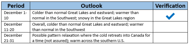
-
Statistical tidbit from 1990-91 through 2024-25: 14/15 (93%) of winters with above normal seasonal snowfall had a least one day with 8" or more snow (72% prior to 1990-91) 17/18 (94%) of winters with below normal seasonal snowfall did not have any 8" or above daily amounts (75% prior to 1990-91) 14/17 (82%) of winters with at least one day with 8" or above snowfall had above normal seasonal snowfall (63% prior to 1990-91) 2014-15 with 50.3" seasonal snowfall was the lone exception for seasons with above normal snowfall with a maximum daily amount of 7.5" since 1990-91. This data suggests that in the contemporary warmer climate, a big snowstorm has become relatively more important to seasonal snowfall outcomes than in the past. Both subsets are longer than 30 seasons in length suggesting that the difference provides some insight. Moreover, this is what would be expected in a warmer climate with somewhat fewer snowy days.
-
2025-2026 ENSO
donsutherland1 replied to 40/70 Benchmark's topic in Weather Forecasting and Discussion
Below is why a relaxation is possible during December 20-31. The WPO is forecast to become less negative while a PNA-, EPO+,AO+, NAO+ regime is largely in place. The WPO would no longer be sufficiently negative to offset the impact of unfavorable teleconnections. Fortunately, that's still far out where skill is low, so it's a plausible but not yet certain outcome.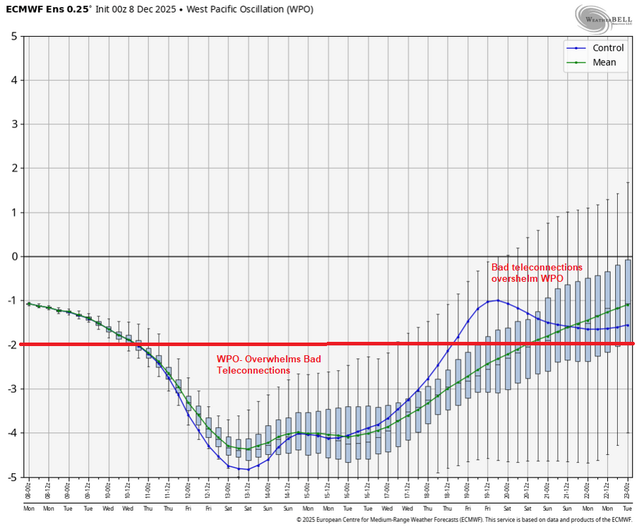
-
Do the best you can during these difficult times. Don’t lose hope. Both of you are in my thoughts and prayers.
-
A fresh surge of cold air will arrive tonight. Tomorrow will likely see subfreezing temperatures across much of the region and Tuesday morning could rival or even surpass the cold of December 5th at some locations. The ongoing stretch of below normal temperatures will likely continue into or through the second week of December. December 1-10 will be a solidly colder than normal period. The potential exists for the coldest first 10 days of December since at least 2007 (33.4°, 5th coldest December 1-10 since 2000). The five coldest December 1-10 periods since 2000 were: 1. 30.6°, 2002 2. 32.2°, 2003 3. 32.4°, 2000 4. 33.1°, 2005 5. 33.4°, 2007 All 5 of these cases had measurable snowfall in Central Park. The WPO is forecast to become strongly negative beyond December 10th. That would likely contribute to the December 10-20 period also being colder to perhaps much colder than normal overall. The probability that December 2025 will have a maximum monthly temperature below 60° is increasing. The last time that happened was in 2019 when the monthly high was 58°. If 2025 has a monthly high below 60°, that would be only the fifth such occurrence since 2000 (2003, 2004, 2005, and 2019 are the cases since 2000). The ENSO Region 1+2 anomaly was -0.1°C and the Region 3.4 anomaly was -0.6°C for the week centered around November 26. For the past six weeks, the ENSO Region 1+2 anomaly has averaged -0.18°C and the ENSO Region 3.4 anomaly has averaged -0.67°C. La Niña conditions will likely continue through at least mid-winter. The SOI was -7.11 today. The preliminary Arctic Oscillation (AO) was -2.202 today. Based on sensitivity analysis applied to the latest guidance, there is an implied near 89% probability that New York City will have a cooler than normal December (1991-2020 normal). December will likely finish with a mean temperature near 34.0° (5.1° below normal). Supplemental Information: The projected mean would be 3.5° below the 1981-2010 normal monthly value.
-
December 2025 regional war/obs/disco thread
donsutherland1 replied to Torch Tiger's topic in New England
Here's the data for Boston:
-
2025-2026 ENSO
donsutherland1 replied to 40/70 Benchmark's topic in Weather Forecasting and Discussion
If the WPO relaxes from its forecast values of -2.000 or below, other teleconnections can gain influence over the pattern. The EPS currently forecasts an EPO+/AO+/PNA-/NAO+ regime toward the end of its run. If the WPO rises, that could allow ridging to expand across the CONUS with warmth following after a few days lag. December 30-31, 1999: The December 30-31, 1999 composite 500 mb map is one example of how unfavorable teleconnections overwhelmed a weaker WPO-. Then, the WPO was still impressive (below -1.000) but it was not at the extreme values necessary to overwhelm the pattern. Milder conditions rapidly spread into the East. Despite much above normal temperatures to start January 2000, the month wound up colder than normal. Late January (January 24-27 timeframe) saw a major snowstorm in the Southeast and lower Mid-Atlantic region. For now, it looks to remain generally colder than normal through around December 20th. Nothing is cast in stone for the remainder of the month, though some temporary relaxation is plausible. IMO, the odds remain against a complete breakdown of the pattern and the onset of a sustained warm pattern during the closing 10-11 days of December. Still, it's worth watching the evolution of the guidance. I suspect that there could be an increased risk of a pattern breakdown after mid-January, which often happens during La Niña winters, but that's in the speculative range right now. The PNA could play a larger role in how January evolves.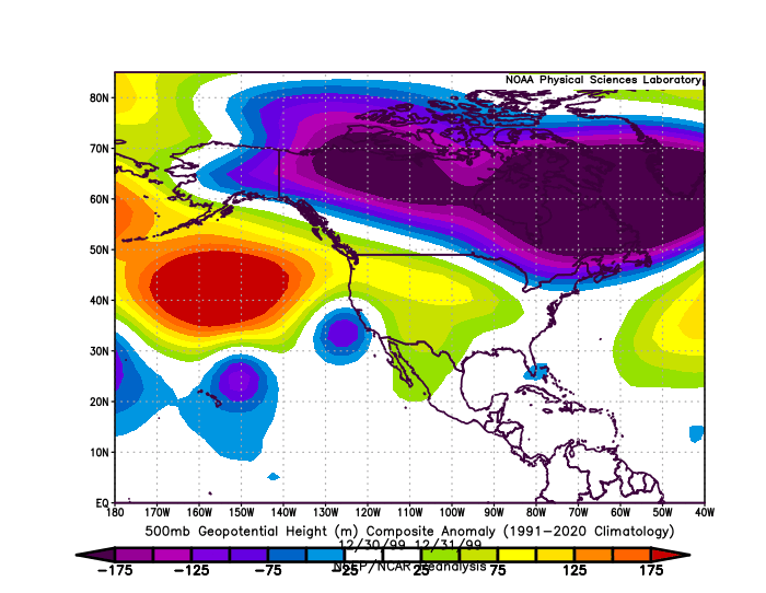
-
The Department of Sanitation was in its own insular bubble that day with no idea of the imminent storm, even as Philadelphia was seeing 1/4-mile visibilities for hours. Maybe they could have followed observations here and learned about the snow.
-
This morning's snowfall totals: Bridgeport: Trace Central Park: Trace LaGuardia Airport: Trace Newark: 0.1"
-
Parts of the region received dustings and even coatings from bursts of light snow that fell overnight into the early morning due to pockets of instability. Newark picked up 0.1". The weekend will end on an unseasonably cool note. A fresh surge of cold air will arrive tomorrow night. Monday will likely see subfreezing temperatures across much of the region and Tuesday morning could rival or even surpass the cold of December 5th. The ongoing stretch of below normal temperatures will likely continue into or through the second week of December. December 1-10 will be a solidly colder than normal period. The potential exists for the coldest first 10 days of December since at least 2007 (33.4°, 5th coldest December 1-10 since 2000). The five coldest December 1-10 periods since 2000 were: 1. 30.6°, 2002 2. 32.2°, 2003 3. 32.4°, 2000 4. 33.1°, 2005 5. 33.4°, 2007 All 5 of these cases had measurable snowfall in Central Park. The WPO is forecast to become strongly negative beyond December 10th. That would likely contribute to the December 10-20 period also being colder to perhaps much colder than normal. The probability that December 2025 will have a maximum monthly temperature below 60° is increasing. The last time that happened was in 2019 when the monthly high was 58°. If 2025 has a monthly high below 60°, that would be only the fifth such occurrence since 2000 (2003, 2004, 2005, and 2019 are the cases since 2000). The ENSO Region 1+2 anomaly was -0.1°C and the Region 3.4 anomaly was -0.6°C for the week centered around November 26. For the past six weeks, the ENSO Region 1+2 anomaly has averaged -0.18°C and the ENSO Region 3.4 anomaly has averaged -0.67°C. La Niña conditions will likely continue through at least mid-winter. The SOI was -23.41 today. The preliminary Arctic Oscillation (AO) was -1.756 today.
-
2025-2026 ENSO
donsutherland1 replied to 40/70 Benchmark's topic in Weather Forecasting and Discussion
My comment regarding snowfall only goes through December 20th. I think if things grow more favorable for the East Coast, it would be during the December 20-31 period as things stand now. Things can still change beforehand, because teleconnections forecasts lose skill beyond 10-14 days. -
2025-2026 ENSO
donsutherland1 replied to 40/70 Benchmark's topic in Weather Forecasting and Discussion
Today's PNA value was -0.355 with five of the first six days of December seeing negative values. The forecast calls for a continuation of the negative PNA: Nevertheless, the WPO is forecast to dive to below -2.000 on the EPS and to -3.000 or below on the GEFS. As a result, a foundation is being laid for much of eastern North America to wind up colder to perhaps even much colder than normal during the December 11-20 period. This pattern would tend to focus the snows on the Great Lakes region while the East Coast sees lesser snows. PNA- setups typically favor lighter snows on the East Coast. The single exception during December since 1980 was the Boxing Day Blizzard of 2010. Such strongly negative WPO cases also see warmer than normal conditions in the Southwest.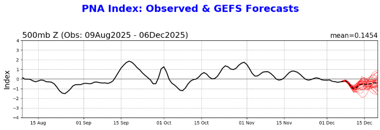
-
I haven't seen any messages as of now.
-
Some brief periods of light snow produced a dusting in Larchmont in southern Westchester County.
-
Washington, D.C.'s distribution of December days with measurable snowfall and the highest daily amount for each date. Highest percentage of 1" or above amounts: December 10 5.7% days (8 cases) Highest percentage of 6" or above amounts: December 24 1.4% days (2 cases)
-
Congratulations to your family and you.
-
A weak system brought an area of 1"-3" of snow to parts of Virginia and Maryland with a few locally higher amounts. Washington, D.C. picked up 1.1" of snow. Meanwhile, farther north in the New York City area, the temperature fell to near record and record lows in parts of the region this morning. Low temperatures included: Albany: -1° (old record: 2°, 1886, 1926, and 1929) ***Coldest so early in the season since 1976*** Binghamton: 3° (old record: 5°, 1971 and 1989) Boston: 12° Hartford: 5° Islip: 21° New Haven: 14° (old record: 15°, 1966) New York City-Central Park: 20° New York City-JFK Airport: 20° (tied record set in 1966) New York City-LaGuardia Airport: 20° (old record: 21°, 1942) Newark: 20° Philadelphia: 25° Poughkeepsie: 6° (old record: 7°, 1966 and 1989) Providence: 13° White Plains: 14° (tied record set in 1966) The weekend will be cool but dry. A fresh surge of cold air will arrive Sunday night. The ongoing stretch of below normal temperatures will likely continue into or through the second week of December. December 1-10 will be a solidly colder than normal period. The potential exists for the coldest first 10 days of December since at least 2007 (33.4°, 5th coldest December 1-10 since 2000). The five coldest December 1-10 periods since 2000 were: 1. 30.6°, 2002 2. 32.2°, 2003 3. 32.4°, 2000 4. 33.1°, 2005 5. 33.4°, 2007 All 5 of these cases had measurable snowfall in Central Park. The ENSO Region 1+2 anomaly was -0.1°C and the Region 3.4 anomaly was -0.6°C for the week centered around November 26. For the past six weeks, the ENSO Region 1+2 anomaly has averaged -0.18°C and the ENSO Region 3.4 anomaly has averaged -0.67°C. La Niña conditions will likely continue through at least mid-winter. The SOI was -33.01 today. The preliminary Arctic Oscillation (AO) was -0.968 today.
-
0.8”
-
878 NOUS41 KLWX 051709 PNSLWX DCZ001-MDZ001-003>006-008-011-013-014-016>018-501>508-VAZ025>031- 036>040-050>057-501>508-WVZ050>053-055-501>506-060509- Public Information Statement Spotter Reports National Weather Service Baltimore MD/Washington DC 1209 PM EST Fri Dec 05 2025 The following are unofficial observations taken during the past 3 hours for the storm that has been affecting our region. Appreciation is extended to cooperative and CoCoRaHS observers, Skywarn spotters and media for these reports. This summary also is available on our home page at weather.gov/baltimore ********************STORM TOTAL SNOWFALL******************** LOCATION TOTAL TIME/DATE COMMENTS SNOWFALL MEASURED (inches) DISTRICT OF COLUMBIA ...District of Columbia... American University 1.1 1100 AM 12/05 Broadcast Media MARYLAND ...Baltimore County... Edgemere 0.2 1052 AM 12/05 Trained Spotter Reisterstown 1 NE T 911 AM 12/05 Trained Spotter Bentley Springs 1 E T 1130 AM 12/05 Trained Spotter ...Calvert County... Prince Frederick 1 S 1.5 1000 AM 12/05 Trained Spotter Chesapeake Beach 1.5 911 AM 12/05 Trained Spotter ...Carroll County... Eldersburg 1 ESE 0.5 935 AM 12/05 Trained Spotter ...Charles County... Waldorf 2 W 2.0 935 AM 12/05 Trained Spotter ...Frederick County... Point of Rocks 1 NE 0.8 915 AM 12/05 Trained Spotter Adamstown 1 ESE 0.6 1000 AM 12/05 NWS Employee New Market 2 NW 0.5 930 AM 12/05 Trained Spotter ...Garrett County... Oakland 0.5 1039 AM 12/05 Dept of Highways Grantsville 5 W 0.5 1038 AM 12/05 Dept of Highways Grantsville 4 E 0.5 1040 AM 12/05 Dept of Highways ...Harford County... Bel Air 2 NE 0.5 1140 AM 12/05 Broadcast Media Chrome Hill 2 SE 0.3 1122 AM 12/05 Trained Spotter Forest Hill 2 SW 0.1 930 AM 12/05 Trained Spotter ...Howard County... Elkridge 1.4 1140 AM 12/05 NWS Employee Laurel 2 N 1.0 1200 PM 12/05 Trained Spotter Gaither 2 SE 0.6 1200 PM 12/05 Trained Spotter ...Montgomery County... Gaithersburg 1.5 935 AM 12/05 Emergency Mngr Norbeck 1 ESE 1.4 945 AM 12/05 Trained Spotter Washington Grove 1 N 1.3 1000 AM 12/05 Trained Spotter Damascus 3 SSW 1.2 1003 AM 12/05 Co-Op Observer Gaithersburg 1 SW 1.2 1015 AM 12/05 Trained Spotter Damascus 1 S 1.1 924 AM 12/05 Trained Spotter Bradley Farms 1 SSW 1.0 1044 AM 12/05 NWS Employee ...St. Marys County... California 2 W 2.2 1125 AM 12/05 Trained Spotter California 3 W 1.3 1103 AM 12/05 Trained Spotter VIRGINIA ...Albemarle County... Crozet 1 W 4.2 930 AM 12/05 Trained Spotter Earlysville 3 NW 3.0 1028 AM 12/05 Trained Spotter ...Arlington County... Rosslyn W 1.7 1100 AM 12/05 Trained Spotter Baileys Crossroads 1 1.6 1110 AM 12/05 Trained Spotter Barcroft 1 WNW 1.4 946 AM 12/05 Trained Spotter Reagan National Apt 1.1 1000 AM 12/05 Official NWS Obs ...Augusta County... Staunton Arpt 3 WSW 3.5 925 AM 12/05 Broadcast Media Summerdean 3 SE 3.5 1041 AM 12/05 Broadcast Media Greenwood 3 NNW 3.0 1145 AM 12/05 Public Afton 1 WNW 3.0 1150 AM 12/05 Public ...City of Alexandria... Alexandria 1 W 0.8 945 AM 12/05 Trained Spotter ...City of Fredericksburg... Dunavant 1 S 3.0 1000 AM 12/05 Trained Spotter Fredericksburg 2 E 1.8 1150 AM 12/05 Trained Spotter ...Clarke County... Berryville 1 NNW 1.0 945 AM 12/05 Trained Spotter ...Culpeper County... Culpeper 1 W 1.4 1015 AM 12/05 Trained Spotter ...Fairfax County... Herndon 1 NNE 1.0 1020 AM 12/05 NWS Employee ...Frederick County... Stephens City 2 E 1.5 1030 AM 12/05 Trained Spotter ...Highland County... Hightown 5 NW 3.0 951 AM 12/05 Public Hightown 3 NW 3.0 953 AM 12/05 Public Monterey 3.0 1009 AM 12/05 Dept of Highways ...Loudoun County... Hughesville 2 W 1.6 918 AM 12/05 Trained Spotter Ashburn N 1.5 1000 AM 12/05 Trained Spotter Arcola 1 NNE 1.3 1040 AM 12/05 Trained Spotter Arcola 3 S 1.2 1050 AM 12/05 Trained Spotter Dulles International 1.1 1012 AM 12/05 Official NWS Obs ...Madison County... Big Meadows 2.5 1141 AM 12/05 Public ...Nelson County... Wintergreen 5.0 1015 AM 12/05 Law Enforcement Wintergreen 2 WSW 5.0 1018 AM 12/05 Law Enforcement Shipman 1 WNW 4.0 1000 AM 12/05 Trained Spotter Rockfish 2 WNW 3.8 1015 AM 12/05 Trained Spotter ...Page County... Stanley 2 WSW 2.0 1000 AM 12/05 Trained Spotter ...Prince William County... Manassas 3 SSE 1.5 1015 AM 12/05 Trained Spotter Woolsey 1 SW 1.2 930 AM 12/05 Trained Spotter ...Rockingham County... Clover Hill 3 WSW 3.0 932 AM 12/05 Broadcast Media Broadway 3.0 1042 AM 12/05 Broadcast Media Cherry Grove 3.0 948 AM 12/05 Dept of Highways Swift Run 2.0 1142 AM 12/05 Public Massanutten 1 SE 2.0 1100 AM 12/05 Trained Spotter Elkton 1.9 1132 AM 12/05 Public ...Shenandoah County... Basye 2.0 922 AM 12/05 Broadcast Media ...Stafford County... Fredericksburg 4 NW 1.8 1123 AM 12/05 Public ...Warren County... Front Royal 1.5 1143 AM 12/05 Public Linden 3 W 1.3 1037 AM 12/05 Trained Spotter WEST VIRGINIA ...Grant County... Petersburg 1.0 1012 AM 12/05 Dept of Highways ...Hardy County... Bean Settlement 2.0 1054 AM 12/05 Dept of Highways Baker 2.0 1052 AM 12/05 Dept of Highways Wardensville 1.5 1055 AM 12/05 Dept of Highways Moorefield 1.5 1051 AM 12/05 Dept of Highways ...Pendleton County... Circleville 3.5 1034 AM 12/05 Trained Spotter Seneca Rocks 2.9 1014 AM 12/05 Public Franklin 1 N 2.8 939 AM 12/05 Emergency Mngr Franklin 2.8 947 AM 12/05 Dept of Highways **********************24 HOUR SNOWFALL********************** LOCATION 24 HOUR TIME/DATE COMMENTS SNOWFALL MEASURED (inches) MARYLAND ...Charles County... La Plata 6 SE 2.5 1000 AM 12/05 CoCoRaHS VIRGINIA ...Highland County... Mill Gap 1 SW 3.2 1000 AM 12/05 Co-Op Observer ...Loudoun County... Lovettsville 3 ESE 0.7 917 AM 12/05 CoCoRaHS &&
-
Actually, it's more common than it might appear. Since 1884-85, Washington, DC recorded an earlier first measurable snowfall in 52 (36.6%) cases than New York City. The most recent such case occurred during Winter 2023-2024. Since 2000, Washington saw an earlier first measurable snowfall in the following seasons: 2003-2004 2005-2006 2009-2010 2010-2011 2023-2024 2025-2026
-
2025-2026 ENSO
donsutherland1 replied to 40/70 Benchmark's topic in Weather Forecasting and Discussion
Four of the first five days of December have seen the PNA come in with daily values < 0. The baseline idea of a predominantly negative PNA for December appears on course, especially if the latest guidance winds up being reasonably accurate. Latest GEFS PNA forecast: However, the WPO is forecast to be strongly negative. As a result, the WPO should overwhelm the PNA- and allow generally colder than normal conditions to persist in much of the eastern half of North America during the December 10-20 period. Some milder days are plausible, but the period will likely feature below normal temperatures overall. The Southeast has the highest probability of seeing a break in the cold due to the PNA- connection to SE ridging. The most recent ECMWF weekly forecasts: December 8-15: December 15-22:


-
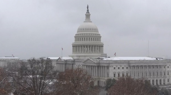
Source: Capitol Camera
-
2025-2026 ENSO
donsutherland1 replied to 40/70 Benchmark's topic in Weather Forecasting and Discussion
The sample size is too small for meaningful comparisons. However, 10-20 days after the bottom, there wasn't a clear increase in subtropical moisture during La Niña and borderline La Niña/neutral-cool winters. In a few cases, there was an atmospheric river directed at the West Coast. -
The temperature fell to 0F (-17.8C) in Albany. That broke the daily record of 2F (-16.7C) that was set in 1886 and tied in 1926 and 1989. It is also Albany's coldest temperature so early in the season since December 3, 1976 when the mercury hit -1F (-18.3C).
-
2025-2026 ENSO
donsutherland1 replied to 40/70 Benchmark's topic in Weather Forecasting and Discussion
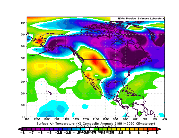
The EPS and GEFS are indicating that the WPO will spend much of the December 10-20 period at or below -2.000. Regardless of whether the EPO is positive, AO is positive, and PNA is negative, severely negative WPO patterns tend to overwhelm the impact of the other teleconnections. Such patterns typically feature colder than normal conditions in the eastern half of North America and warmer conditions in the western half. December 15-18, 2013 offers a representative case with the distribution of warm and cold anomalies: