donsutherland1
-
Posts
23,988 -
Joined
Content Type
Profiles
Blogs
Forums
American Weather
Media Demo
Store
Gallery
Everything posted by donsutherland1
-
2025-2026 ENSO
donsutherland1 replied to 40/70 Benchmark's topic in Weather Forecasting and Discussion
It will be interesting to see how things evolve. Since 1980, December PNA- cases have been followed by January PNA+ cases. Prior to 1980, December PNA- cases were generally followed by January PNA- cases. It is possible that the less stable PNA state is, at least in part, a result of Arctic amplification.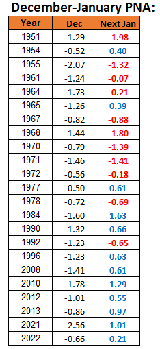
-
2025-2026 ENSO
donsutherland1 replied to 40/70 Benchmark's topic in Weather Forecasting and Discussion
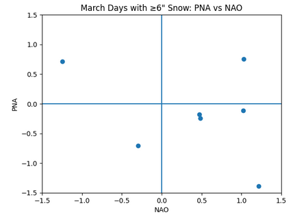
Here's some data for NYC for January and March (1980-2025):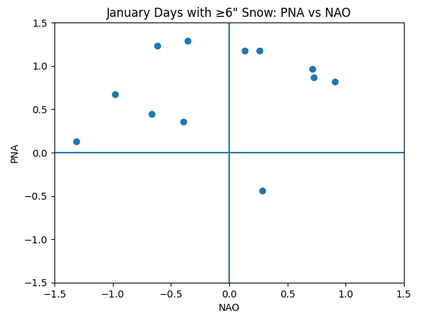
-
2025-2026 ENSO
donsutherland1 replied to 40/70 Benchmark's topic in Weather Forecasting and Discussion
I suspect that when it comes to snowstorms in parts of the Southeast, more is involved than the pattern itself. Synoptic details are critical and outweigh the teleconnections. One sees a similar outcome in the spring in the Middle Atlantic region as wave lengths shorten and the state of the teleconnections becomes less important. -
2025-2026 ENSO
donsutherland1 replied to 40/70 Benchmark's topic in Weather Forecasting and Discussion
Perhaps. However, the December 2010 blizzard was a Miller B system. Baltimore: Trace Boston: 18.2" Islip: 14.2" New York City: 20.0" Newark: 24.2" Philadelphia: 12.4" Washington, DC: 0.4" Wilmington, DE: 3.5" -
2025-2026 ENSO
donsutherland1 replied to 40/70 Benchmark's topic in Weather Forecasting and Discussion
While the AO and NAO are looking good on the latest GEFS, the PNA is not.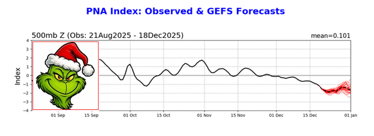
-
2025-2026 ENSO
donsutherland1 replied to 40/70 Benchmark's topic in Weather Forecasting and Discussion
In general, a PNA- pattern results in lighter snowfalls in the New York City area and northern Mid-Atlantic. The Boxing Day blizzard is a notable exception and the only KU snowstorm during December when the PNA was negative. -
This morning, the low temperature at Central Park was 36° while the lows at Bridgeport and White Plains were 24° and 25° respectively. That is the largest difference in low temperatures between Central Park and Bridgeport and Central Park and White Plains this month. The last time these differences were matched or exceeded was November 25, 2025 when Central Park had a low of 46°, Bridgeport had a low of 34°, and White Plains had a low of 35°.
-
2025-2026 ENSO
donsutherland1 replied to 40/70 Benchmark's topic in Weather Forecasting and Discussion
For reference, the December and January snowfalls for New York City (1980-Present) with the teleconnections you listed: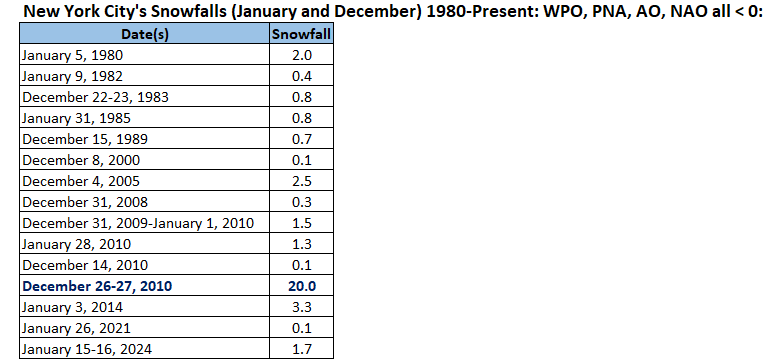
-
Occasional Thoughts on Climate Change
donsutherland1 replied to donsutherland1's topic in Climate Change
Arctic sea ice extent (JAXA) has demolished the old record for lowest start to December. That record was set just last year.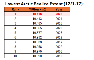
-
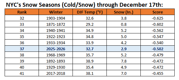
Winter 2025-2026 is off to the 37th best start in terms of cold and snow in New York City. Records go back to 1869-1870.
-
Tomorrow and Friday will be mild days with highs reaching or exceeding 50° in parts of the region. Friday will be the warmer day with highs in the 50s across much of the region. A soaking rain is likely tomorrow night and Friday. Much of the region could see a general 0.50"-1.50" of rain. Behind the storm, the weekend will turn somewhat cooler. No exceptionally cold or warm weather appears likely for the first week of astronomical winter. The probability that December 2025 will have a maximum monthly temperature below 60° has continued to increase. The last time that happened was in 2019 when the monthly high was 58°. If 2025 has a monthly high below 60°, that would be only the fifth such occurrence since 2000 (2003, 2004, 2005, and 2019 are the cases since 2000). The ENSO Region 1+2 anomaly was -0.3°C and the Region 3.4 anomaly was -0.7°C for the week centered around December 10. For the past six weeks, the ENSO Region 1+2 anomaly has averaged -0.33°C and the ENSO Region 3.4 anomaly has averaged -0.67°C. La Niña conditions will likely continue through at least mid-winter. The SOI was -4.26 today. The preliminary Arctic Oscillation (AO) was +2.532 today. Based on sensitivity analysis applied to the latest guidance, there is an implied near 99% probability that New York City will have a cooler than normal December (1991-2020 normal). December will likely finish with a mean temperature near 34.0° (5.1° below normal). Supplemental Information: The projected mean would be 3.4° below the 1981-2010 normal monthly value.
-
2025-2026 ENSO
donsutherland1 replied to 40/70 Benchmark's topic in Weather Forecasting and Discussion
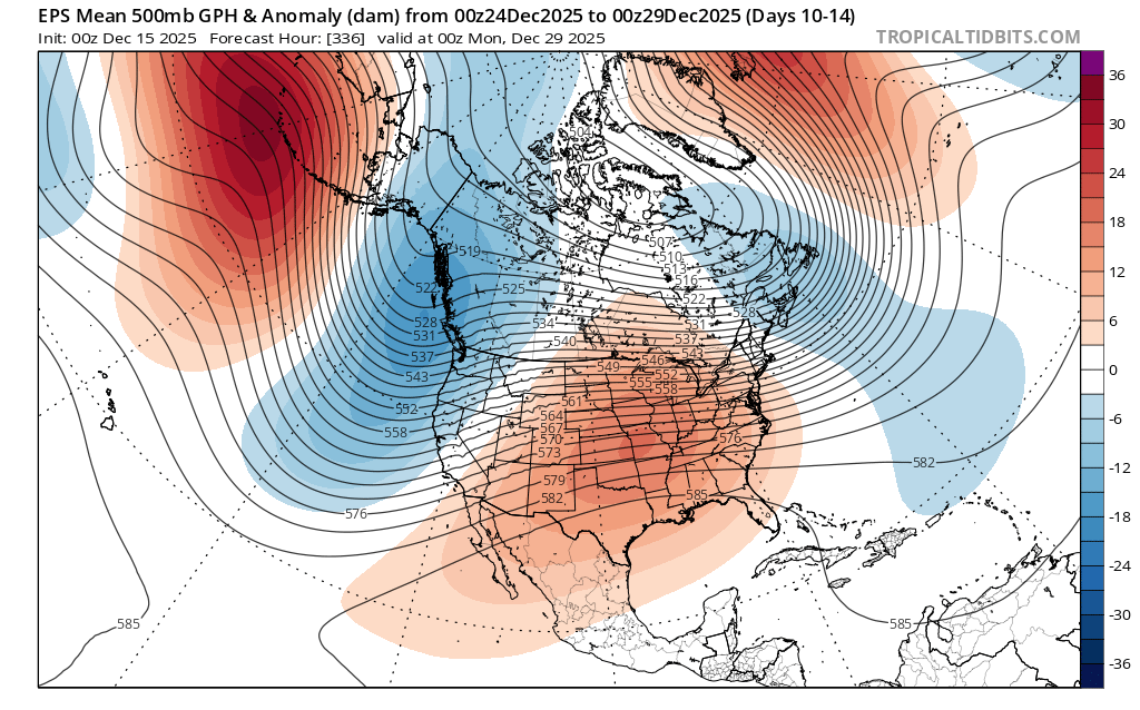
The EPS ensembles' 10-14-day outlook highlights how I think the cold will likely hang on longest in the Northeast/parts of eastern Canada consistent with the forecast teleconnections.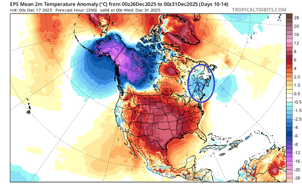
-
2025-2026 ENSO
donsutherland1 replied to 40/70 Benchmark's topic in Weather Forecasting and Discussion
New York City's UHI has been around for decades. The numbers are warmer there, but the differences between cooler or warmer outcomes relative to climatology apply. Having said that, there are day-to-day issues at the Park. Actually, Central Park's December lows relative to those at White Plains have changed very little. Of course, when conditions are ripe for radiational cooling, there will be large temperature differences between Central Park and White Plains.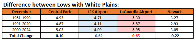
-
2025-2026 ENSO
donsutherland1 replied to 40/70 Benchmark's topic in Weather Forecasting and Discussion
I may not have refreshed the chart from the EPO. When the NAO is negative, the pattern is cooler (36.4°). The larger idea that the Northeast will likely avoid a "torch" pattern through December still holds in either case. It's uncertain whether the warmth will break through to start January, but that's still far in the extended future. -
2025-2026 ENSO
donsutherland1 replied to 40/70 Benchmark's topic in Weather Forecasting and Discussion
The latest guidance shows a WPO-, EPO+, NAO+, PNA- pattern for late December. This pattern typically is not a "torch" in the Northeastern U.S. and eastern Canada. Using New York City as an example, some statistics: December 20-31, 1980-2024: Mean temperature: 38.0° (1991-2020 Mean: 37.4°) Distribution of Highs: 30s: 19% 40s: 63% 50s: 6% 60s: 13% Lowest: 33° Highest: 65° Distribution of Lows: 20s: 38% 30s: 50% 40s: 13% Lowest: 24° Highest: 42° Unfortunately, the cooler conditions aren't widespread. The Northeast tends to be a cooler exception in such patterns. Much of the southern U.S. tends to be warm to very warm. -
2025-2026 ENSO
donsutherland1 replied to 40/70 Benchmark's topic in Weather Forecasting and Discussion
I have no big changes from yesterday. Going forward, the WPO- is likely to become less negative and the EPO could go negative for a time, which would blunt the full effects of warming across the northern tier of the U.S. and especially Canada. The PNA will remain persistently negative. The changes favor a Southeast ridge, strong trough in the Pacific Northwest, and a weakening trough over the Northeast and eastern Canada. Thus, the southern tier of the U.S. and perhaps most of the CONUS could see a warmer than normal December 20-31 period overall. The warmup could take time to develop in New England and the upper Midwest. Canada should remain broadly colder than normal for the period overall. There's a chance that the warmth could finally overspread the Northeast as December concludes and January starts. Should an EPO+/AO+ pattern develop, that would increase prospects for warmth in the Northeast. The EPS favors a near neutral AO while the GEFS favors a negative one. -
Temperatures will moderate for tomorrow through Friday. Thursday and Friday will be mild days with the mercury approaching or reaching 50° in parts of the region. A soaling rain is likely Thursday night and Friday. Much of the region could see a general 0.50"-1.50" of rain. Behind the storm, the weekend will turn somewhat cooler. The probability that December 2025 will have a maximum monthly temperature below 60° is increasing. The last time that happened was in 2019 when the monthly high was 58°. If 2025 has a monthly high below 60°, that would be only the fifth such occurrence since 2000 (2003, 2004, 2005, and 2019 are the cases since 2000). The ENSO Region 1+2 anomaly was -0.3°C and the Region 3.4 anomaly was -0.7°C for the week centered around December 10. For the past six weeks, the ENSO Region 1+2 anomaly has averaged -0.33°C and the ENSO Region 3.4 anomaly has averaged -0.67°C. La Niña conditions will likely continue through at least mid-winter. The SOI was -0.88 today. The preliminary Arctic Oscillation (AO) was +1.524 today. Based on sensitivity analysis applied to the latest guidance, there is an implied near 97% probability that New York City will have a cooler than normal December (1991-2020 normal). December will likely finish with a mean temperature near 34.3° (4.8° below normal). Supplemental Information: The projected mean would be 3.1° below the 1981-2010 normal monthly value.
-
2025-2026 ENSO
donsutherland1 replied to 40/70 Benchmark's topic in Weather Forecasting and Discussion
Since 1980, for December cases with a WPO of -2 or below: PNA<0: 84.1%; PNA>0: 15.9%. -
Tomorrow will be another cold day. Temperatures will then moderate for Wednesday through Friday. Thursday and Friday could be mild days with the mercury approaching or reaching 50° in parts of the region. Rain is likely on Friday. Behind the storm, the weekend will turn somewhat cooler. The probability that December 2025 will have a maximum monthly temperature below 60° is increasing. The last time that happened was in 2019 when the monthly high was 58°. If 2025 has a monthly high below 60°, that would be only the fifth such occurrence since 2000 (2003, 2004, 2005, and 2019 are the cases since 2000). The ENSO Region 1+2 anomaly was -0.3°C and the Region 3.4 anomaly was -0.7°C for the week centered around December 10. For the past six weeks, the ENSO Region 1+2 anomaly has averaged -0.33°C and the ENSO Region 3.4 anomaly has averaged -0.67°C. La Niña conditions will likely continue through at least mid-winter. The SOI was +0.26 today. The preliminary Arctic Oscillation (AO) was +2.095 today. Based on sensitivity analysis applied to the latest guidance, there is an implied near 97% probability that New York City will have a cooler than normal December (1991-2020 normal). December will likely finish with a mean temperature near 34.3° (4.8° below normal). Supplemental Information: The projected mean would be 3.1° below the 1981-2010 normal monthly value.
-
2025-2026 ENSO
donsutherland1 replied to 40/70 Benchmark's topic in Weather Forecasting and Discussion
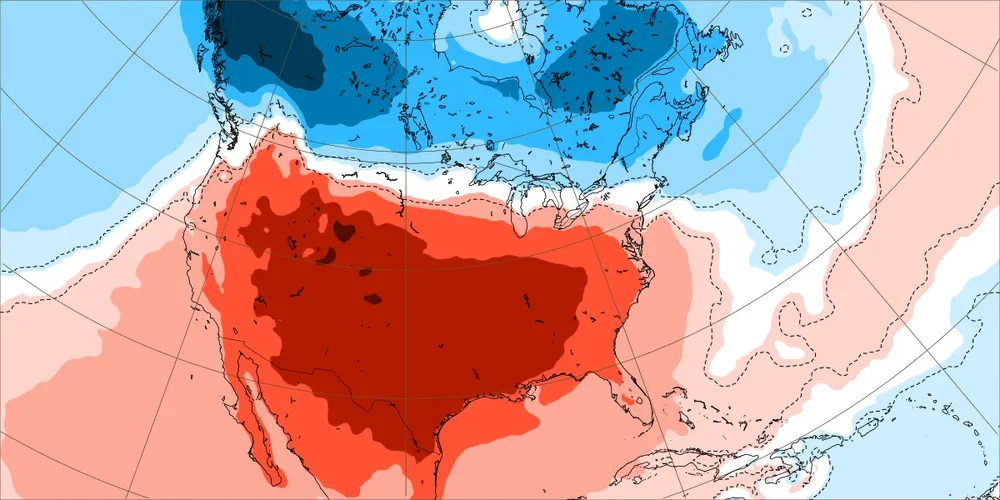
New York City saw its coldest first two weeks of December since 2005. The cold was even more impressive elsewhere: Charlottesville, VA (3rd coldest); Jackson, KY (3rd coldest); Marquette (2nd coldest); Paducah (4th coldest); and, Scranton (5th coldest). There was also impressive warmth in other parts of the northwestern U.S. Boise (4th warmest); Burns, OR (2nd warmest); Missoula (3rd warmest); Pocatello (3rd warmest); and, Yakima (1st warmest). The most persistent teleconnections were the WPO- (which tanked) and the PNA-. Going forward, the WPO- is likely to become less negative, cutting off the unrelenting flow of cold air into western Canada and then the northern U.S. The EPO could go negative, which would blunt the full effects of warming across the northern tier of the U.S. and especially Canada. The PNA will remain persistently negative. The changes favor a Southeast ridge, strong trough in the Pacific Northwest, and a weakening trough over the Northeast and eastern Canada. Thus, the southern tier of the U.S. and perhaps most of the CONUS could see a warmer than normal December 20-31 period overall. The warmup could take time to develop in New England and the upper Midwest. Canada should remain broadly colder than normal for the period overall. The latest Day 10-14 forecast on the EPS illustrates a 500 mb pattern that is broadly what one would expect from the forecast teleconnections during that period. The GEFS is in good agreement with the EPS for that timeframe. Here's the December 22-29 weekly ECMWF forecast: Notice how New England and parts of the northernmost U.S. has near normal or even below normal temperatures. Canada is cold from coast-to-coast. Finally, the GEFS is showing a scenario similar to December 28-31, 2021 where warm anomalies develop in much of eastern Canada. Whether this is something that will occur toward the close of December or a bit later in January remains to be seen. The EPS and ECMWF weeklies keep eastern Canada cooler than normal albeit less cool than shown above through the remainder of December. For now, the EPS is the baseline scenario for the closing days of December. That would allow for some intrusions of cooler air into the Northeast.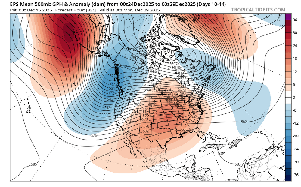
-
Yes. That's part of the random element of timing with such records. Those records are interesting but that's about it with them.
-
The 4.4" was an error. The NOWdata has now been corrected to 2.9". In the PNS, there was a report near Central Park that showed 3.1", so the 2.9" is probably reasonable (maybe several tenths low?) this time around.
-
Yes. Sometimes data gets in and is automatically flagged and corrected. Occasionally, errors persist and the corrections are made manually. The prior erroneous 72° high for October 2 is one such example. It was corrected in late November.
-
I'm waiting to hear back. The daily climate report and CF-6 showed 2.9". NOWdata, which goes into xmACIS, showed 4.4".
-
Walt, Thank you for all you have done throughout your career and here. Your generosity, skill, and class made an indelible difference wherever you've gone. I wish you continued health and time with your family. Very best wishes always, Don