-
Posts
23,890 -
Joined
Content Type
Profiles
Blogs
Forums
American Weather
Media Demo
Store
Gallery
Everything posted by donsutherland1
-

Nov 28-30th Post Turkey Day Winter Storm
donsutherland1 replied to Chicago Storm's topic in Lakes/Ohio Valley
-
Central Park has recorded its first freeze of the 2025-2026 season. The 1991-2020 normal first date is November 21. The 1961-1990 baseline was November 11. Last winter's first freeze occurred on November 30.
-
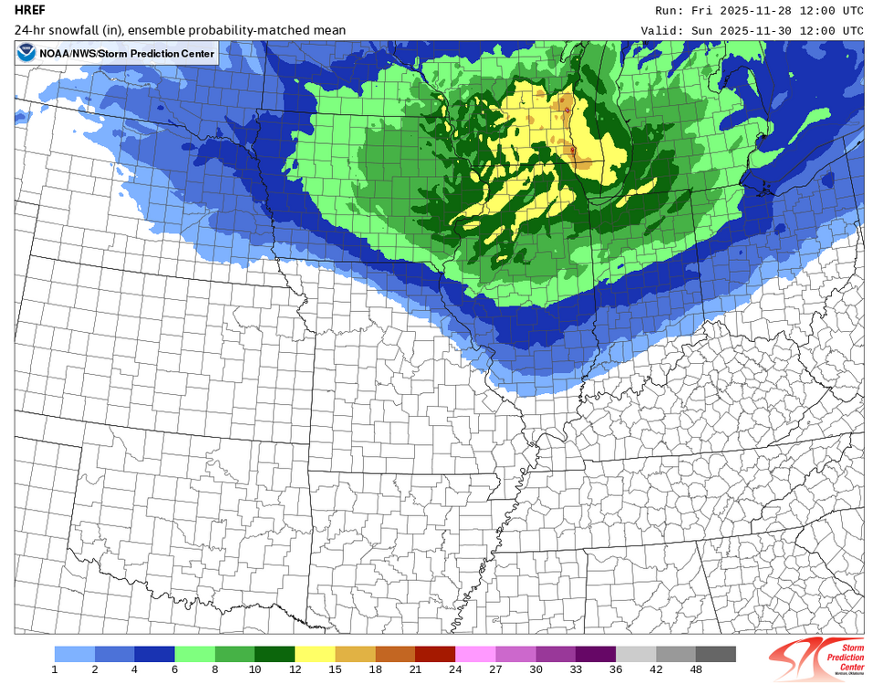
Tomorrow will be unseasonably cold. There is potential for New York City's Central Park to experience its first freeze of 2025 tomorrow morning. The 1991-2020 normal first date is November 21. The 1961-1990 baseline was November 11. Last winter's first freeze occurred on November 30. Saturday and Sunday will see a snowstorm blanket parts of the Great Lakes Region. Chicago and Milwaukee could see 6"-12" of snow. Detroit could pick up 4"-8". Toronto could see 3"-6". Sunday and Monday will be somewhat milder. Showers are possible on Monday as a cold front moves across the region. Generally colder than normal conditions could then continue into or through the second week of December. Severe cold appears unlikely through at least the first 10 days of December. Nevertheless, December 1-10 will be a solidly colder than normal period. Moreover, a storm could affect the region on Tuesday into Wednesday, bringing 0.50"-1.50" precipitation to the region. There is a distinct possibility that New York City could see its first measurable snowfall of the season. Interior sections have the highest probability of seeing accumulations of snow. The ENSO Region 1+2 anomaly was -0.7°C and the Region 3.4 anomaly was -0.7°C for the week centered around November 12. For the past six weeks, the ENSO Region 1+2 anomaly has averaged -0.16°C and the ENSO Region 3.4 anomaly has averaged -0.65°C. La Niña conditions will likely continue through at least mid-winter. The SOI was -3.12 today. The preliminary Arctic Oscillation (AO) was +0.081 today. Based on sensitivity analysis applied to the latest guidance, there is an implied 99% probability that New York City will have a cooler than normal November (1991-2020 normal). November will likely finish with a mean temperature near 47.2° (0.8° below normal). Supplemental Information: The projected mean would be 0.5° below the 1981-2010 normal monthly value.
-
-

Nov 28-30th Post Turkey Day Winter Storm
donsutherland1 replied to Chicago Storm's topic in Lakes/Ohio Valley
-

2025-2026 ENSO
donsutherland1 replied to 40/70 Benchmark's topic in Weather Forecasting and Discussion
-

2025-2026 ENSO
donsutherland1 replied to 40/70 Benchmark's topic in Weather Forecasting and Discussion
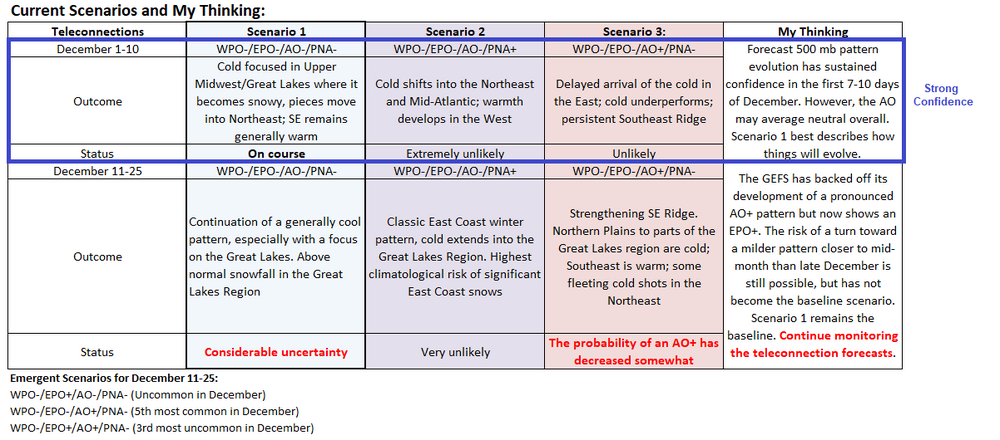
Yesterday, I noted that the GEFS was trying to push an EPO+, but its forecast 500 mb pattern was profoundly different from any of the December WPO-/EPO+/AO-/PNA- clusters. That suggested that either the teleconnection idea was off or the pattern was off, rather than some novel outcome. Overnight and through today's 6z cycle, the GEFS has continued to evolve. It has added a WPO+ to its EPO+ idea and restored its earlier idea of a AO+. It has now joined the Canadian ensembles that keep the MJO out of Phase 8 through its forecast horizon. In short, its previously significant areas of "disconnect" have disappeared overnight. Its forecast pattern is now more consistent with what one would expect. For now, the GEFS is trying to build a credible milder alternative scenario for the pattern/temperature evolution in North America toward mid-December. The EPS has not shifted toward that emerging GEFS idea. Therefore, the baseline idea remains that the northern tier of the U.S. and most of Canada should remain cold toward and probably beyond mid-December. The Southeast could still turn warm despite some shots of colder air. Mid-December and beyond is still in the low-skill distant realm. The big story through the weekend will be the significant snowstorm that will affect parts of the Midwest and Great Lakes Region. As a result, Chicago, Detroit, Milwaukee, and Toronto remain on track to experience their snowiest fall in five or more years. As an appetizer, Detroit added 0.1" snowfall yesterday and Toronto picked up 1.2 cm (0.5") yesterday. -
Tomorrow and Saturday will be unseasonably cold days. Tomorrow will be windy with a possibility of some snow flurries. There is potential for New York City's Central Park to experience its first freeze of 2025 tomorrow or, more likely, Saturday morning. The 1991-2020 normal first date is November 21. The 1961-1990 baseline was November 11. Last winter's first freeze occurred on November 30. Saturday and Sunday will see a snowstorm blanket parts of the Great Lakes Region. Chicago and Milwaukee could see 6"-12" of snow. Detroit could pick up 4"-8". Toronto could see 3"-6". Sunday and Monday will turn somewhat milder. Showers are possible on Monday as a cold front moves across the region. Generally colder than normal conditions could then continue into or through the second week of December. Severe cold appears unlikely through at least the first 10 days of December. Moreover, a storm could affect the region on Tuesday into Wednesday, bringing 0.50"-1.50" precipitation to the region. There is a distinct possibility that New York City could see its first measurable snowfall of the season. Interior sections have the highest probability of seeing accumulations of snow. The ENSO Region 1+2 anomaly was -0.7°C and the Region 3.4 anomaly was -0.7°C for the week centered around November 12. For the past six weeks, the ENSO Region 1+2 anomaly has averaged -0.16°C and the ENSO Region 3.4 anomaly has averaged -0.65°C. La Niña conditions will likely continue through at least mid-winter. The SOI was +1.97 today. The preliminary Arctic Oscillation (AO) was +0.036 today. Based on sensitivity analysis applied to the latest guidance, there is an implied 96% probability that New York City will have a cooler than normal November (1991-2020 normal). November will likely finish with a mean temperature near 47.1° (0.9° below normal). Supplemental Information: The projected mean would be 0.6° below the 1981-2010 normal monthly value.
-

Nov 28-30th Post Turkey Day Winter Storm
donsutherland1 replied to Chicago Storm's topic in Lakes/Ohio Valley
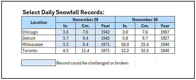
For reference: The 33.5 cm snowfall at Toronto on November 30, 1940 is the biggest daily snowfall on record for November. The 10.0" for Milwaukee on November 30, 1940 is the second biggest daily snowfall on record for November. -
-

2025-2026 ENSO
donsutherland1 replied to 40/70 Benchmark's topic in Weather Forecasting and Discussion
I'm not that surprised. The 11/27 0z cycle reflects yesterday's development where the GEFS backed off its development of a pronounced AO+ pattern. It is trying to push an EPO+, but its 500 mb pattern is profoundly different from any of the December WPO-/EPO+/AO-/PNA- clusters. Assuming that the simplest explanation is more likely, the pattern disconnect from its forecast teleconnections suggests that either the teleconnection idea is off or the pattern is off, rather than some novel outcome. The pattern closely resembles the EPS, which does not show an EPO+ pattern. Thus, I suspect that the EPS has a better handle on the overall pattern right now. The northern tier of the U.S. and most of Canada should remain cold toward and probably beyond mid-month if that holds. Unfortunately, the SE could still turn warm despite some shots of colder air. -

2025-2026 ENSO
donsutherland1 replied to 40/70 Benchmark's topic in Weather Forecasting and Discussion
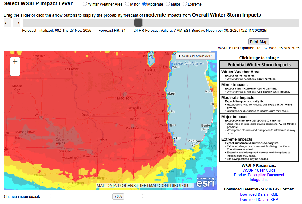
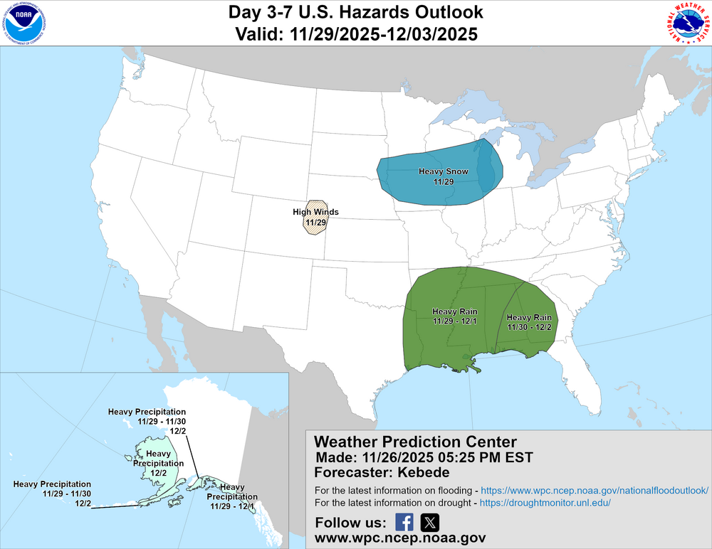
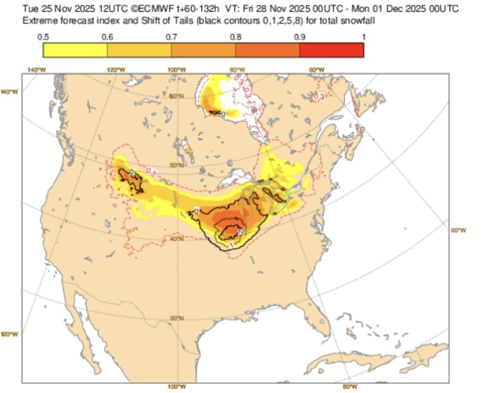
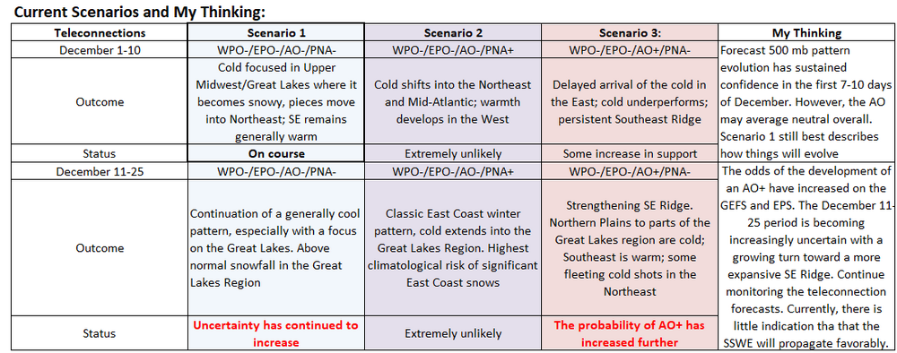
The pattern evolution for the opening 10 days of December still looks very good. With respect to the December 11-25 period, the guidance has shifted. For a time, the GEFS was showing the development of a pronounced AO+ pattern. Now, it has backed off (12z and 18z cycles). As a consequence, the baseline Scenario 1 still seems to be the best one going forward, while recognizing that there is some risk of a break near mid-month. The latest ECMWF weekly forecast largely maintains the sensible weather effects from Scenario 1. Given the shifting of the guidance, it makes sense to continue to monitor the teleconnections (and other factors) while reserving judgment for changes until later to avoid making changes based more on model noise than actual developments. Milwaukee, Chicago, Detroit, and Toronto remain in line for a snowstorm during the November 29-30 period. Significant snow is possible in Milwaukee and Chicago. A moderate snowfall looks reasonable for both Detroit and Toronto. Changes can still occur. WPC is now showing a 70% chance of a moderate winter storm impact in Chicago and surrounding areas for the 24-hour period ending November 30 7 am. Chicago remains on course to experience its snowiest fall since 2019 (8.3") and possibly even 2018 (12.7"). Milwaukee should see its snowiest fall since 2019 (13.4"). Detroit will likely experience its snowiest fall since 2021 (7.1") and possibly 2019 (9.5"). Toronto could see its snowiest fall since 2020 (23.4 cm/9.2") and perhaps 2002 (27.2 cm/10.7"). Fall 2025 Snowfall Totals (through November 26): Chicago: 1.7" Detroit: 2.2" Milwaukee: 0.6" Toronto: 12.8 cm (5.0") -
In the wake of the storm that brought rain to the region last night into early today, colder air will rush into the region tonight. The closing days of November will be much colder. There is potential for New York City's Central Park to experience its first freeze of 2025. The 1991-2020 normal first data is November 21. The 1961-1990 baseline was November 11. Last winter's first freeze occurred on November 30. The opening days of December will turn somewhat milder. However, colder conditions could begin to develop during the second half of that week and then continue into or through the second week of December. Severe cold appears unlikely through at least the first 10 days of December. The ENSO Region 1+2 anomaly was -0.7°C and the Region 3.4 anomaly was -0.7°C for the week centered around November 12. For the past six weeks, the ENSO Region 1+2 anomaly has averaged -0.16°C and the ENSO Region 3.4 anomaly has averaged -0.65°C. La Niña conditions will likely continue through at least mid-winter. The SOI was +20.23 today. The preliminary Arctic Oscillation (AO) was -0.232 today. Based on sensitivity analysis applied to the latest guidance, there is an implied 94% probability that New York City will have a cooler than normal November (1991-2020 normal). November will likely finish with a mean temperature near 46.9° (1.1° below normal). Supplemental Information: The projected mean would be 0.8° below the 1981-2010 normal monthly value.
-

2025-2026 ENSO
donsutherland1 replied to 40/70 Benchmark's topic in Weather Forecasting and Discussion
Things continue to evolve nicely toward a cold and snowy pattern in the Upper Midwest and Great Lakes Region with the cold then expanding eastward. The probability of a moderate to significant snowfall in such cities as Chicago, Detroit, Milwaukee, and Toronto during November 29-30 has increased. As a result, Chicago will likely see its snowiest autumn since 2019 and possibly 2018. As the cold spreads into the East, at least some accumulations of snow are likely across Central/Upstate New York and central/northern New England. There is even a chance that some snow could reach the coastal plain, especially from New Jersey north and eastward. Statistically, during December 1980-2024, 11% of days have seen measurable snowfall in New York City when the EPO, WPO, and PNA were negative. That would translate into an expected value of 1.1 days during the December 1-10 period. Significant (6" or above) snowstorms have not occurred during the first half of December when the PNA was negative (1950-2024). Boston has seen three significant snowfalls during a PNA- during the first half of December, the biggest being 10.5" during December 13-14, 2007 (NYC saw 0.2" from that storm). -

2025-2026 ENSO
donsutherland1 replied to 40/70 Benchmark's topic in Weather Forecasting and Discussion
A colder pattern is now poised to develop in the Upper Midwest and Great Lakes Region. The odds of a moderate (4" or above) to perhaps significant snowfall (6" or above) in Chicago Saturday into Sunday has increased. The daily record snowfall for November 29-30 is as follows: November 29: 3.0", 1942 November 30: 3.0", 1907 Those 3.0" amounts are also the two-day records for November 29-30. Even if the daily mark isn't set on either day, the two-day figure for November 29-30 will likely be broken. In the wake of the storm, Chicago will likely have its snowiest fall since 2019 when 8.3" of snow was recorded. The snow should then spread into Detroit, Windsor, and Toronto Saturday night and Sunday. -
Periods of rain are likely tonight into tomorrow morning. Tomorrow will be unseasonably mild with temperatures topping out in the upper 50s and lower 60s across the region. Colder air will rush into the region tomorrow night. The closing days of November will be much colder. There is potential for New York City's Central Park to experience its first freeze of 2025. The 1991-2020 normal first data is November 21. The 1961-1990 baseline was November 11. Last winter's first freeze occurred on November 30. The opening days of December will turn milder. However, colder conditions could begin to develop during the second half of that week and continue through the second week of December. Severe cold appears unlikely through at least the first 10 days of December. The ENSO Region 1+2 anomaly was -0.7°C and the Region 3.4 anomaly was -0.7°C for the week centered around November 12. For the past six weeks, the ENSO Region 1+2 anomaly has averaged -0.16°C and the ENSO Region 3.4 anomaly has averaged -0.65°C. La Niña conditions will likely continue through at least mid-winter. The SOI was +7.63 today. The preliminary Arctic Oscillation (AO) was -0.426 today. Based on sensitivity analysis applied to the latest guidance, there is an implied 90% probability that New York City will have a cooler than normal November (1991-2020 normal). November will likely finish with a mean temperature near 46.9° (1.1° below normal). Supplemental Information: The projected mean would be 0.8° below the 1981-2010 normal monthly value.
-

2025-2026 ENSO
donsutherland1 replied to 40/70 Benchmark's topic in Weather Forecasting and Discussion
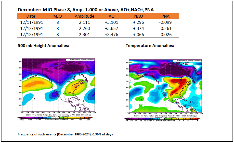
Those are rare outcomes. For December, there have been just 5 dates that saw such criteria (1980-2024). -

2025-2026 ENSO
donsutherland1 replied to 40/70 Benchmark's topic in Weather Forecasting and Discussion
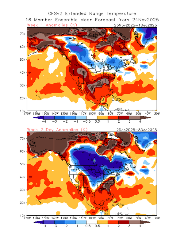
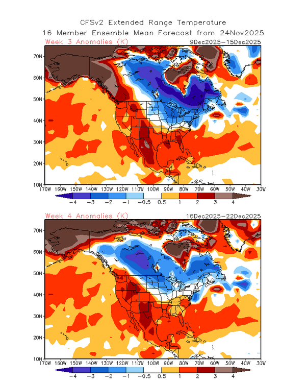
This is pretty much the consensus idea for the first 10 days of December. The cold will spread through the Upper Midwest, the Great Lakes and then eastward. Some pieces could reach the Southeast as the ridge is flattened for a time. Unfortunately, if the latest guidance is right, like a champion fighter, the SE Ridge will pick itself up and keep coming back. Then, if some of the more recent guidance is right, namely the development of an AO+ pattern, the ridge could rebuild. The Great Lakes Area (Chicago, Detroit, Milwaukee, Toronto) and northern New England/eastern Canada should see a continuation of the cold past mid-December and perhaps onward. I suspect that snow will develop in the Chicago area late Saturday or Saturday night and then spread into Detroit and Toronto afterward. A moderate snowfall appears likely. -

2025-2026 ENSO
donsutherland1 replied to 40/70 Benchmark's topic in Weather Forecasting and Discussion
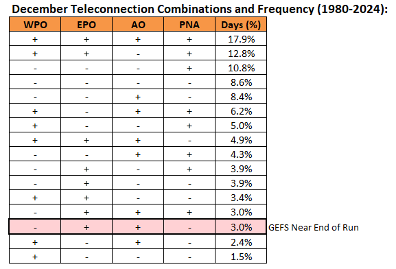
The 0z GEFS was showing one of the more uncommon December teleconnection combinations near the end of its forecast period. -

2025-2026 ENSO
donsutherland1 replied to 40/70 Benchmark's topic in Weather Forecasting and Discussion
-

2025-2026 ENSO
donsutherland1 replied to 40/70 Benchmark's topic in Weather Forecasting and Discussion
That’s one possible factor that has led me to continue to monitor the period. By the end of November, I think there will be greater clarity. -

2025-2026 ENSO
donsutherland1 replied to 40/70 Benchmark's topic in Weather Forecasting and Discussion
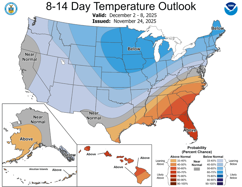
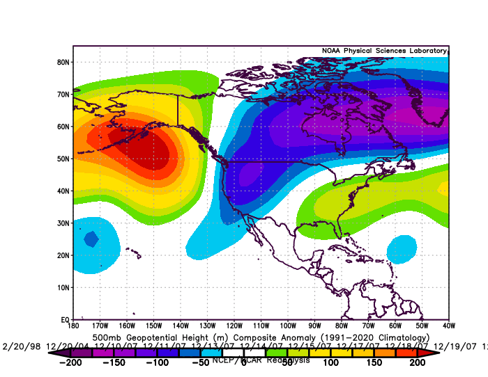
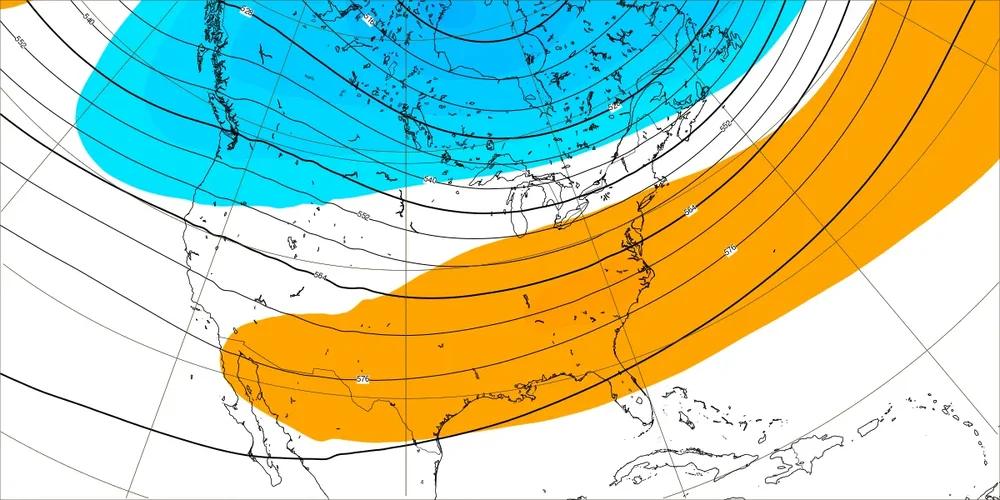
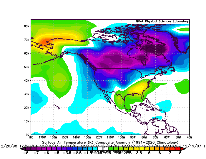
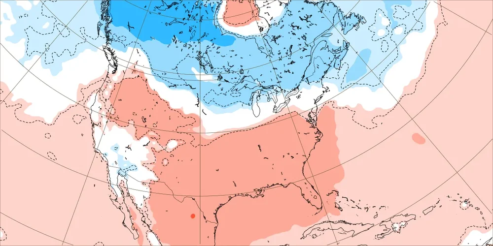
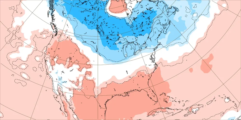
Continuing the illustration showing how I'm thinking about December 1-10 and December 11-25. Here's the framework I am using. The CPC 8-14 day forecast is a good illustration of how I think things will evolve during the December 1-10 period: The risks of a faster turn to a warmer pattern in much of the eastern U.S. (not the Great Lakes, northern New England, eastern Canada) have increased with growing ensemble consensus for a predominantly AO+ pattern. Composite WPO-/EPO-/AO+/PNA- 500 mb Height Anomalies: ECMWF Weekly 500 mb Forecast for December 8-15: Composite WPO-/EPO-/AO+/PNA- Temperature Anomalies: ECMWF Weekly 500 mb 2m Temperature Anomaly Forecast for December 8-15: Right now, the guidance is still in a low-skill timeframe. What's noteworthy is the change that has taken place in the past few days. For example, this was the ECMWF weekly forecast for the December 18-15 period from three days earlier: If the guidance holds or strengthens the forecast AO+ beyond December 10, the warmer outcome could become the baseline for that period with perhaps a mid-month shift to the milder pattern. The 18z GEFS is also suggesting that the EPO could go positive. If so, that would further increase the risks for a turn toward milder conditions. In sum, December 1-10 still remains on track. One should see cold move into the Upper Midwest and Great Lakes and then spread eastward. The Southeast will remain warm due to the resilient SE Ridge. Uncertainty beyond December 10 has increased and the risk of a shift toward a warmer pattern has increased. The guidance will need to be watched closely to see if its turn toward an AO+ persists. -
A generally milder than normal pattern will likely continue through next Wednesday when a system could bring a period of rain. However, exceptional warmth appears unlikely. The closing days of November will likely turn colder. There is potential for New York City's Central Park to experience its first freeze of 2025. The 1991-2020 normal first data is November 21. The 1961-1990 baseline was November 11. Last winter's first freeze occurred on November 30. The opening days of December will turn milder. However, colder conditions could begin to develop during the second half of that week and continue through the second week of December. Severe cold appears unlikely through at least the first 10 days of December. Afterward, the pattern evolution will depend, in part, on how the imminent stratospheric warming event propagates. Meanwhile, today will be Central Park's 1,395th consecutive day without daily snowfall of 4" or more. That breaks the record of 1,394 days was set during February 22, 1929 through December 16, 1932. That stretch ended with 6.7" daily snowfall on December 17, 1932. The ENSO Region 1+2 anomaly was -0.7°C and the Region 3.4 anomaly was -0.7°C for the week centered around November 12. For the past six weeks, the ENSO Region 1+2 anomaly has averaged -0.16°C and the ENSO Region 3.4 anomaly has averaged -0.65°C. La Niña conditions will likely continue through at least mid-winter. The SOI was -1.40 today. The fall of 39.57 points was the largest such fall since April 27, 2006 when the SOI fell 42.35 points. It was also the fourth largest decline on record. The preliminary Arctic Oscillation (AO) was -0.384 today. Based on sensitivity analysis applied to the latest guidance, there is an implied 90% probability that New York City will have a cooler than normal November (1991-2020 normal). November will likely finish with a mean temperature near 46.7° (1.3° below normal). Supplemental Information: The projected mean would be 1.0° below the 1981-2010 normal monthly value.
-
Yes, that's true. The biggest 2-day snowfall during the current streak was 3.2" (February 13-14, 2024). The biggest 2-day snowfall during the prior record streak was December 2, 1929 (3.9").
-

2025-2026 ENSO
donsutherland1 replied to 40/70 Benchmark's topic in Weather Forecasting and Discussion
December 1-10 should start warm but then get cold. The question is whether it remains generally cold into late December or turns milder near mid-month. That’s the part that is increasingly uncertain.


