donsutherland1
-
Posts
23,988 -
Joined
Content Type
Profiles
Blogs
Forums
American Weather
Media Demo
Store
Gallery
Everything posted by donsutherland1
-
JFK Airport has now reached 20°. That ties the daily record that was set in 1966.
-
Some 6 am temperatures: Albany: 2° (tied record set in 1886 and tied in 1926 and 1989) Binghamton: 5° (tied record set in 1971 and tied in 1989) New York City-LaGuardia Airport: 20° (old record: 21°, 1942) White Plains: 14° (tied record set in 1966) Albany has its coldest temperature so early in the season since 1989.
-
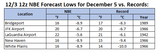
The coldest air mass so far this season is now overspreading the region. The temperature will tumble into the lower 20s by tomorrow morning in New York City. Many areas outside the City will see lows in the teens. Daily record low marks for December 5th could be challenged or broken in Bridgeport, New York City-JFK Airport, New York City-LaGuardia Airport, and White Plains. The weekend will be cool but dry. A fresh surge of cold air could arrive Sunday night. The ongoing stretch of below normal temperatures will likely continue into or through the second week of December. December 1-10 will be a solidly colder than normal period. The potential exists for the coldest first 10 days of December since at least 2007 (33.4°, 5th coldest December 1-10 since 2000). The five coldest December 1-10 periods since 2000 were: 1. 30.6°, 2002 2. 32.2°, 2003 3. 32.4°, 2000 4. 33.1°, 2005 5. 33.4°, 2007 All 5 of these cases had measurable snowfall in Central Park. The ENSO Region 1+2 anomaly was -0.1°C and the Region 3.4 anomaly was -0.6°C for the week centered around November 26. For the past six weeks, the ENSO Region 1+2 anomaly has averaged -0.18°C and the ENSO Region 3.4 anomaly has averaged -0.67°C. La Niña conditions will likely continue through at least mid-winter. The SOI was -43.70 today. That is the lowest SOI figure since February 9, 2024 when the SOI was -46.54. The preliminary Arctic Oscillation (AO) was -0.366 today.
-
Congratulations.
-
And perhaps that figure has increased a little more today with the snow squall that blew through.
-
Winter cancelled/uncancelled banter 25/26
donsutherland1 replied to Rjay's topic in New York City Metro
Retired After Last Use December had begun on a strangely toasty note. The temperature had climbed to a balmy 57° (the third time in the last five years the mercury reached at least 57° on the first day of December), and the New York Public Library, perhaps out of nostalgia, perhaps out of quiet defiance, filled the marble halls of its iconic Beaux-Arts Fifth Avenue building with sepia-toned photographs of children tunneling through drifts taller than themselves. The exhibit captured an era that residents increasingly believed had slipped out of reach. A public weather notice board calling itself "American Weather" had given the display a name that struck Marisol, a student at Columbia University, as both melodramatic and heartbreaking: “The Final Snowfall.” Walking home after a full day of classes, Marisol passed one of Midtown’s newest absurdities: a synthetic snow dome where wealthy Manhattan parents paid $95 an hour to show their children what “winter” once felt like. She never stepped inside. Those plastic flakes felt like an insult. Her father had always said that snow gave New Yorkers a common language of spontaneous generosity. Cheap plastic could never measure up. Almost four years had passed since the last daily snowfall of four inches or more. Even two consecutive snow-starved years had never occurred before. Four such years were unimaginable. As Marisol passed one of American Weather’s public boards, a small sculpture beside it stopped her cold. There stood a dented aluminum snow shovel mounted upright like a relic. At its base, an engraved bronze plaque read, “Retired after last use: February 21, 1929.” She felt her throat tighten. "Snow is something you can only remember now," she thought. Then came the second thought. It was a much darker one, perhaps from having spent too much time reading "American Weather" on her way home from classes. "Soon there will be no one left who remembers at all," she worried. Her grief was premature. Just over two weeks later, a storm swept across the City, dropping 6.7" of snow on December 17 and another half-inch the following day. Less than two months after that, an even larger snowstorm buried Central Park beneath 10.0" of luminous white. Today marks the 1,405th consecutive day without a daily snowfall of four inches or more. Pessimism mixes with fatalism. Yet New York City has lived through snow droughts before, even as this one is the longest on record. As happened in December 1932, the streak will break. Eventually. Even with supercomputers, AI-driven forecasts, and models capable of simulating the atmosphere down to microphysical detail, the exact date of the next significant snowfall remains unknowable at this time. Patience is required. But so is confidence. December is now on course to register its coldest start in more than fifteen years. That's a hopeful start. The arrival of the cold reveals that Winter has not yet forgotten New York City. -
2025-2026 ENSO
donsutherland1 replied to 40/70 Benchmark's topic in Weather Forecasting and Discussion
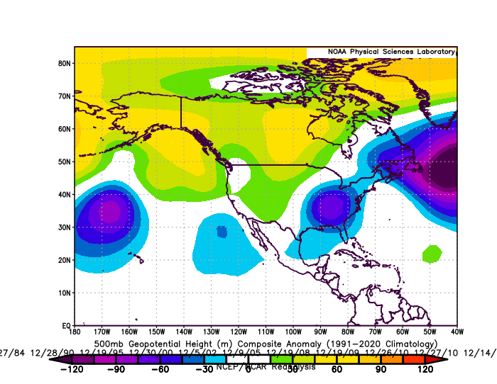
Here's the data for New York City: Below are the composite 500 mb anomalies for WPO<0 December cases for 4" or more daily snowfall. To date, the guidance does not suggest the kind of pattern shown below. It should also be noted that snowfalls tend to be light during the first half of December when the AO/NAO/PNA are all negative.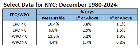
-
2025-2026 ENSO
donsutherland1 replied to 40/70 Benchmark's topic in Weather Forecasting and Discussion
It also looks likely to persist through at least mid-December, if not longer. -
2025-2026 ENSO
donsutherland1 replied to 40/70 Benchmark's topic in Weather Forecasting and Discussion
Yes, there's a different methodology. I use the BOM values when assessing patterns and impacts. -
The coldest air mass so far this season will overspread the region tomorrow night. The cold front could touch off a few scattered snow flurries or snow showers. The temperature will tumble into the lower 20s by Friday morning in New York City. Many areas outside the City will see lows in the teens. It now appears that the weekend will be cool but dry. A colder than normal pattern is in place. A prolonged stretch of below normal temperatures will likely continue into or through the second week of December. December 1-10 will be a solidly colder than normal period. The potential exists for the coldest first 10 days of December since at least 2007 (33.4°, 5th coldest December 1-10 since 2000). The five coldest December 1-10 periods since 2000 were: 1. 30.6°, 2002 2. 32.2°, 2003 3. 32.4°, 2000 4. 33.1°, 2005 5. 33.4°, 2007 All 5 of these cases had measurable snowfall in Central Park. The ENSO Region 1+2 anomaly was -0.1°C and the Region 3.4 anomaly was -0.6°C for the week centered around November 26. For the past six weeks, the ENSO Region 1+2 anomaly has averaged -0.18°C and the ENSO Region 3.4 anomaly has averaged -0.67°C. La Niña conditions will likely continue through at least mid-winter. The SOI was -28.49 today. The preliminary Arctic Oscillation (AO) was -0.144 today.
-
2025-2026 ENSO
donsutherland1 replied to 40/70 Benchmark's topic in Weather Forecasting and Discussion
We agree that he’s brilliant. His MJO work is groundbreaking. On this point, I think he’s extrapolated where the coefficient of determination is fairly low. His overall linkage isn’t wrong, but other factors can easily overwhelm ENSO, the AAM, etc. It will be interesting to see the final outcome. -
2025-2026 ENSO
donsutherland1 replied to 40/70 Benchmark's topic in Weather Forecasting and Discussion
There's an ERA-5 dataset that goes back to 1940. https://www.psl.noaa.gov/mjo/mjoindex/omi.era5.1x.webpage.4023.txt -
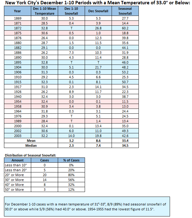
Thank you. It seems that the formula dropped "T" rather than counting it as 0 on the spreadsheet. Mean: 3.5"; median: 2.0"
-
For reference, New York City area locations where daily records could be challenged or broken on December 5th:
-
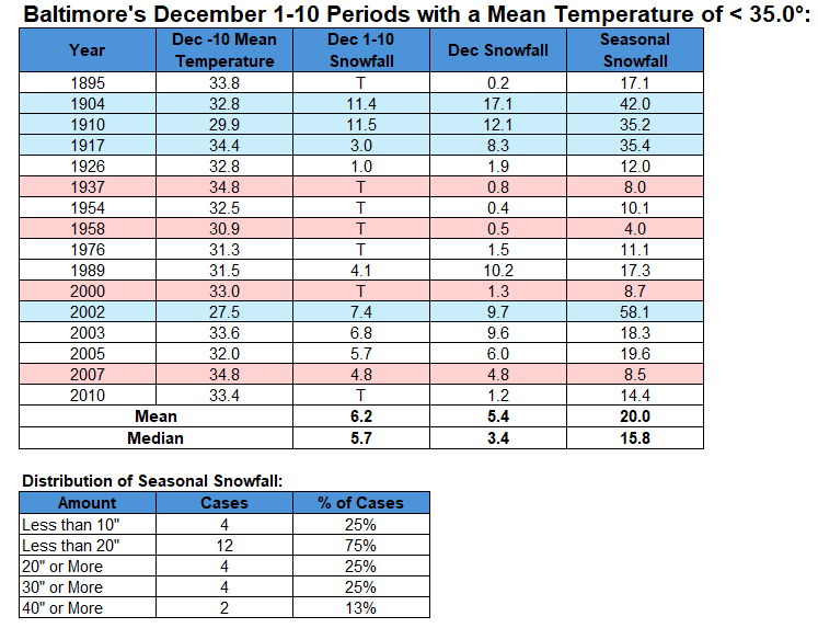
For Baltimore, the snowfall cases are far more mixed.
-
2025-2026 ENSO
donsutherland1 replied to 40/70 Benchmark's topic in Weather Forecasting and Discussion
IMO, this oversimplifies the PNA. A PNA- is not only possible, but is likely to be the predominant state this month based on broad consensus of the guidance. There's a lot more that contributes to the PNA. So far, December has seen PNA values of +0.022 on December 1st and -0.149 on December 2nd. Yesterday's GEFS forecast: Here's the EPS 46-Day forecast: Last winter provides a good example of how one can reach incorrect conclusions from oversimplifying things. Despite the La Niña, the PNA was positive on almost 96% of days. It was also +1.000 or above on 34% of days. ENSO-PNA mismatches can occur. These mismatches are a product of a more complex ocean-atmosphere system than would be suggested by simpler rules. In short, even as there is a tendency for the PNA to be negative during La Niña/positive during El Niño (same direct relationship with regard to the PDO), that tendency is far from iron-clad. All said, I see little at this time to suggest that the base scenario of a PNA- December has grown less likely. The continued persistence of the guidance has, if anything, reinforced the base scenario of a predominant PNA- overall.

-
103 NOUS41 KPHI 022025 PNSPHI DEZ001>004-MDZ012-015-019-020-NJZ001-007>010-012>027-PAZ054-055-060>062-070- 071-101>106-030825- Public Information Statement National Weather Service Mount Holly NJ 325 PM EST Tue Dec 2 2025 ...SNOWFALL AND FREEZING RAIN REPORTS AS OF 3:15 PM 12/2/25... Location Amount Time/Date Provider ...New Jersey... ...Mercer County... Trenton Mercer Airport T in 0700 AM 12/02 ASOS ...Morris County... 1 SW Netcong 1.6 in 1115 AM 12/02 Trained Spotter Green Pond 1.0 in 1050 AM 12/02 Trained Spotter Lake Hopatcong 1.0 in 1045 AM 12/02 Trained Spotter Milton 1.0 in 1150 AM 12/02 Trained Spotter 1 S Butler 0.9 in 1200 PM 12/02 Public 2 SSW Randolph 0.2 in 0200 PM 12/02 Trained Spotter ...Sussex County... Kittatinny Lake 3.6 in 0100 PM 12/02 Trained Spotter Wantage Twp 3.1 in 0200 PM 12/02 Trained Spotter Sussex 2.5 in 0125 PM 12/02 Public 4 WSW Wantage Twp 2.3 in 0100 PM 12/02 Trained Spotter 1 NNE Sparta 2.0 in 1200 PM 12/02 Emergency Mngr Ogdensburg 1.8 in 0145 PM 12/02 Trained Spotter 2 NW Vernon 1.4 in 1250 PM 12/02 Trained Spotter ...Warren County... 1 WSW Blairstown Twp 2.2 in 1145 AM 12/02 Trained Spotter Hackettstown 0.5 in 1115 AM 12/02 Trained Spotter Stewartsville 0.5 in 0930 AM 12/02 Trained Spotter ...Pennsylvania... ...Berks County... Leesport 1.7 in 1037 AM 12/02 Trained Spotter Reading Regional Airport 0.7 in 0100 PM 12/02 ASOS Huffs Church 0.6 in 0930 AM 12/02 Trained Spotter Morgantown 0.3 in 0852 AM 12/02 Trained Spotter ...Carbon County... 1 ENE Palmerton 3.7 in 1240 PM 12/02 Trained Spotter Jim Thorpe 3.4 in 1155 AM 12/02 Trained Spotter ...Chester County... 1 N East Nantmeal Twp 0.3 in 0830 AM 12/02 Trained Spotter ...Lehigh County... Washington Twp 4.0 in 1130 AM 12/02 Trained Spotter 1 SE North Whitehall Twp 2.0 in 1140 AM 12/02 Trained Spotter 1 NW Schnecksville 2.0 in 1230 PM 12/02 Cocorahs Wescosville 1.4 in 0130 PM 12/02 Trained Spotter Lehigh Valley International 0.8 in 0100 PM 12/02 ASOS Salisbury Twp 0.8 in 0915 AM 12/02 Trained Spotter ...Monroe County... Coolbaugh Twp 5.3 in 0230 PM 12/02 Trained Spotter Mount Pocono 5.3 in 0100 PM 12/02 Trained Spotter Saylorsburg 4.3 in 1200 PM 12/02 Trained Spotter 2 SSE Lake Monroe 3.5 in 1230 PM 12/02 Public 1 SSW Paradise Valley 3.5 in 1120 AM 12/02 Public Pocono Summit 3.5 in 1100 AM 12/02 Trained Spotter 1 E Scotrun 3.2 in 1227 PM 12/02 Trained Spotter 1 N Arlington Heights 2.5 in 1200 PM 12/02 Trained Spotter ...Northampton County... 1 SSE Bushkill Twp 3.1 in 1140 AM 12/02 Trained Spotter Bangor 3.0 in 1200 PM 12/02 Trained Spotter Danielsville 3.0 in 0222 PM 12/02 Trained Spotter 1 E Pen Argyl 2.5 in 1200 PM 12/02 Trained Spotter 3 E Moore Twp 2.2 in 1125 AM 12/02 Trained Spotter Nazareth 2.2 in 1105 AM 12/02 Trained Spotter Martins Creek 1.6 in 1045 AM 12/02 CO-OP Observer ...Philadelphia County... Philadelphia International T in 0700 AM 12/02 ASOS ...FREEZING RAIN REPORTS... Location Amount Time/Date Provider ...Delaware... ...New Castle County... Wilmington T in 0919 AM 12/02 ASOS ...New Jersey... ...Somerset County... Somerville 0.06 in 0127 PM 12/02 ASOS ...Sussex County... Sussex T in 0134 PM 12/02 ASOS ...Pennsylvania... ...Berks County... Reading 0.05 in 1154 AM 12/02 ASOS ...Bucks County... Doylestown 0.05 in 0914 AM 12/02 ASOS ...Lehigh County... Lehigh Valley Intl Airport 0.01 in 1251 PM 12/02 ASOS ...Monroe County... Mt. Pocono 0.01 in 0133 PM 12/02 ASOS ...Montgomery County... Pottstown 0.08 in 1054 AM 12/02 ASOS &&
-
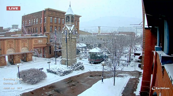
063 NOUS41 KBGM 022104 PNSBGM NYZ009-015>018-022>025-036-037-044>046-055>057-062-PAZ038>040-043-044-047- 048-072-030904- Public Information Statement National Weather Service Binghamton NY 404 PM EST Tue Dec 2 2025 ...SNOWFALL REPORTS FROM PAST 6 HOURS... Location Amount Time/Date Provider ...New York... ...Broome County... 1 SSE Whitney Point 6.2 in 0315 PM 12/02 NWS Employee Whitney Point 6.0 in 1130 AM 12/02 Public NWS Binghamton 5.9 in 0100 PM 12/02 Official NWS Obs 2 SW Lisle 5.8 in 0100 PM 12/02 Trained Spotter Vestal Center 3.9 in 1237 PM 12/02 Trained Spotter 1 N Johnson City 3.6 in 1245 PM 12/02 Broadcast Media Vestal 3.2 E 2.9 in 0140 PM 12/02 COCORAHS Kirkwood 2.7 in 1010 AM 12/02 Public ...Cayuga County... 1 ESE Locke 5.6 in 1245 PM 12/02 NWS Employee ...Chemung County... Horseheads 4.5 in 1227 PM 12/02 Public 1 ESE Horseheads North 4.1 in 1150 AM 12/02 Broadcast Media 1 S Elmira 4.0 in 1155 AM 12/02 Trained Spotter ...Chenango County... Sherburne 6.5 in 0300 PM 12/02 Public Greene 6.0 in 0200 PM 12/02 Public ...Cortland County... Solon 7.0 in 0150 PM 12/02 Public Marathon 6.5 in 0100 PM 12/02 Trained Spotter 1 NE Cortland 5.2 in 1205 PM 12/02 Public ...Delaware County... 1 NE Beerston 8.5 in 0230 PM 12/02 Public Franklin 7.0 in 0145 PM 12/02 Law Enforcement Margaretville 7.0 in 0240 PM 12/02 Public 2 NW Peabrook 5.9 in 0325 PM 12/02 Emergency Mngr Delhi 4.0 in 1045 AM 12/02 Trained Spotter Fishs Eddy 4.0 in 1245 PM 12/02 Public East Meredith 4.0 in 0225 PM 12/02 Public Stamford 4.0 in 0240 PM 12/02 Public Bovina Center 2.0 in 1206 PM 12/02 ...Madison County... Chittenango 6.0 in 1245 PM 12/02 Public 2 SE Chittenango 4.7 in 0227 PM 12/02 Trained Spotter ...Oneida County... Sauquoit 7.0 in 0315 PM 12/02 Public Hinckley 7.0 in 0315 PM 12/02 Public Forestport 6.0 in 1130 AM 12/02 Public Marcy 5.5 in 0100 PM 12/02 Trained Spotter 1 SE Waterville 5.5 in 0315 PM 12/02 Public Whitesboro 5.2 in 0300 PM 12/02 Public Knoxboro 4.0 in 0125 PM 12/02 Trained Spotter Paris 4.0 in 0133 PM 12/02 Trained Spotter Waterville 4.0 in 0315 PM 12/02 Public 3 NE Deerfield 2.6 in 1030 AM 12/02 Broadcast Media ...Onondaga County... Jamesville 5.2 in 1200 PM 12/02 Trained Spotter Tully 0.3 NNW 5.0 in 0300 PM 12/02 COCORAHS ...Otsego County... Hartwick 6.0 in 0350 PM 12/02 Public New Lisbon 5.0 in 1200 PM 12/02 Public 1 NNW Mt Vision 5.0 in 1259 PM 12/02 Public Emmons 4.9 in 0327 PM 12/02 Public ...Schuyler County... Beaver Dams 4.0 in 1055 AM 12/02 Public Tyrone 4.0 in 0150 PM 12/02 Public Montour Falls 4.0 in 0353 PM 12/02 Public 1 NW Hector 3.2 in 1141 AM 12/02 ...Seneca County... 1 WNW Townsendville 3.0 in 1130 AM 12/02 Public ...Steuben County... Cameron Mills 5.0 in 0351 PM 12/02 Public Painted Post 0.7 SSE 4.5 in 0100 PM 12/02 COCORAHS Corning 3.8 in 1200 PM 12/02 Public Jasper 3.0 in 1120 AM 12/02 Public ...Sullivan County... Narrowsburg 8.0 in 0225 PM 12/02 Public Jeffersonville 8.0 in 0330 PM 12/02 Public 4 E Grahamsville 6.5 in 0230 PM 12/02 Public Liberty 6.0 in 0240 PM 12/02 Public 1 E Callicoon Center 5.0 in 1046 AM 12/02 Trained Spotter Wurtsboro 5.0 in 0330 PM 12/02 Public Woodbourne 3.5 in 1056 AM 12/02 Public Jeffersonville 2.5 in 1005 AM 12/02 Public ...Tioga County... 1 SSW Newark Valley 7.0 in 0240 PM 12/02 NWS Employee 2 WSW Nanticoke 6.0 in 1119 AM 12/02 Berkshire 6.0 in 0136 PM 12/02 Trained Spotter Richford 6.0 in 0245 PM 12/02 Public Tioga Terrace 2.3 in 1222 PM 12/02 Trained Spotter ...Tompkins County... Freeville 6.5 in 0345 PM 12/02 Public West Danby 5.5 in 1200 PM 12/02 Trained Spotter Newfield 5.0 in 1150 AM 12/02 Public Newfield 5.0 in 0353 PM 12/02 Public Trumansburg 4.3 in 0140 PM 12/02 Trained Spotter 1 SW Forest Home 4.3 in 0320 PM 12/02 Public Enfield 4.0 in 0200 PM 12/02 Public ...Pennsylvania... ...Bradford County... Sayre 3.8 in 1200 PM 12/02 Trained Spotter Athens 1.2 N 3.3 in 0100 PM 12/02 COCORAHS 1 S Sayre 3.3 in 0105 PM 12/02 ...Lackawanna County... 2 WNW Springbrook Corner 7.0 in 0100 PM 12/02 Public 1 NW Jessup 5.4 in 0234 PM 12/02 Taylor 4.2 in 0215 PM 12/02 Trained Spotter 2 NNE Moosic 4.2 in 0220 PM 12/02 Official NWS Obs Wallsville 4.0 in 1200 PM 12/02 Amateur Radio Waverly 4.0 in 1240 PM 12/02 Trained Spotter 1 SSW Oakhill 4.0 in 0100 PM 12/02 Trained Spotter Clarks Summit 3.5 in 1100 AM 12/02 Public ...Luzerne County... Edwardsville 5.3 in 1249 PM 12/02 Trained Spotter 1 NNE Sugar Notch 5.0 in 1220 PM 12/02 Trained Spotter Dallas 5.0 in 1225 PM 12/02 Public 1 SE Albert 4.6 in 0104 PM 12/02 Pittston 4.0 in 1200 PM 12/02 Amateur Radio ...Pike County... 1 ENE Twin Lakes 6.5 in 0320 PM 12/02 Public Rowland 6.0 in 1230 PM 12/02 Amateur Radio 4 ENE Milford 4.0 in 1246 PM 12/02 Public ...Susquehanna County... Brackney 5.0 in 1200 PM 12/02 Amateur Radio Forest City 4.8 in 0200 PM 12/02 Public Susquehanna 4.5 in 1200 PM 12/02 Amateur Radio Uniondale 4.5 in 0310 PM 12/02 Public ...Wayne County... 2 W Damascus 8.0 in 0345 PM 12/02 Public Lakewood 5.0 in 1200 PM 12/02 Amateur Radio Equinunk 5.0 in 1230 PM 12/02 Amateur Radio Lake Como 5.0 in 0345 PM 12/02 Emergency Mngr Honesdale 4.5 in 1200 PM 12/02 Amateur Radio Newfoundland 4.0 in 1230 PM 12/02 Amateur Radio Greentown 3.5 in 1200 PM 12/02 Amateur Radio Orson 2.8 in 1200 PM 12/02 Amateur Radio ...Wyoming County... Falls 5.0 in 0300 PM 12/02 Public 1 ESE Mill City 4.5 in 0220 PM 12/02 Trained Spotter &&
-
612 NOUS41 KOKX 022136 PNSOKX CTZ005>012-NJZ002-004-006-103>108-NYZ067>075-078>081-176>179-030936- Public Information Statement National Weather Service New York NY 436 PM EST Tue Dec 2 2025 ...SNOWFALL REPORTS... Location Amount Time/Date Provider ...Connecticut... ...Fairfield County... 4 NNW New Fairfield 2.5 in 0404 PM 12/02 Trained Spotter ...New York... ...Orange County... 2 SW Middletown 3.9 in 0330 PM 12/02 Fire Dept/Rescue 2 S Montgomery Airport 3.1 in 0301 PM 12/02 Public 1 WNW Monroe 2.5 in 1245 PM 12/02 Trained Spotter 1 NNE Chester 2.3 in 0112 PM 12/02 Trained Spotter Pine Bush 2.2 in 1220 PM 12/02 Public 1 WSW Balmville 2.2 in 0130 PM 12/02 Public 2 E Highland Mills 2.2 in 0157 PM 12/02 Public 2 SSW Middletown 2.0 in 1209 PM 12/02 Trained Spotter 1 NNE Chester 2.0 in 1230 PM 12/02 Trained Spotter 2 SSW Stewart Airport 2.0 in 0144 PM 12/02 Public 3 WNW Warwick 2.0 in 0340 PM 12/02 Public Chester 1.0 in 1056 AM 12/02 Cocorahs ...Westchester County... Peekskill 1.1 in 1200 PM 12/02 Public &&
-
While New York City and its immediate suburbs experienced a cold rain, parts of the region saw some snow. Peekskill picked up 1.1" of snow. 2 SW of Middletown received 3.9". Binghamton saw 5.9". A colder than normal pattern is in place. A prolonged stretch of below normal temperatures will likely continue into or through the second week of December. December 1-10 will be a solidly colder than normal period. The potential exists for the coldest first 10 days of December since at least 2007 (33.4°, 5th coldest December 1-10 since 2000). The five coldest December 1-10 periods since 2000 were: 1. 30.6°, 2002 2. 32.2°, 2003 3. 32.4°, 2000 4. 33.1°, 2005 5. 33.4°, 2007 All 5 of these cases had measurable snowfall in Central Park. Rain will end tonight. Tomorrow will be blustery and cool with highs in the upper 30s and lower 40s. The coldest air mass so far this season will overspread the region starting Thursday or Thursday night. The temperature will tumble into the 20s Thursday night before bottoming out in the lower 20s Friday morning. It now appears that the weekend will be cool but dry. The ENSO Region 1+2 anomaly was -0.1°C and the Region 3.4 anomaly was -0.6°C for the week centered around November 26. For the past six weeks, the ENSO Region 1+2 anomaly has averaged -0.18°C and the ENSO Region 3.4 anomaly has averaged -0.67°C. La Niña conditions will likely continue through at least mid-winter. The SOI was -11.42 today. The preliminary Arctic Oscillation (AO) was +0.016 today.
-
Some fun statistics. Whether things actually wind up like the often snowy winters associated with a very cold start to December remains to be seen.
-
Arctic Sea Ice Extent, Area, and Volume
donsutherland1 replied to ORH_wxman's topic in Climate Change
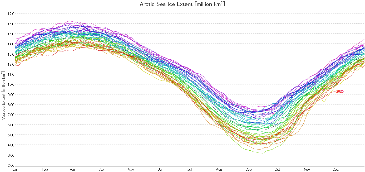
Overall, Arctic sea ice extent is far below the prior record for December 1st. On December 1, Arctic sea ice extent was 9.342 million square kilometers. That was 419,000 square kilometers below the prior record that had been set in 2016. The 2010s average was 10.450 million square kilometers. The 1980s figure was 12.137 million square kilometers. 2024 and 2025 is the first case where two consecutive years saw less than 10 million square kilometers on December 1. Source: JAXA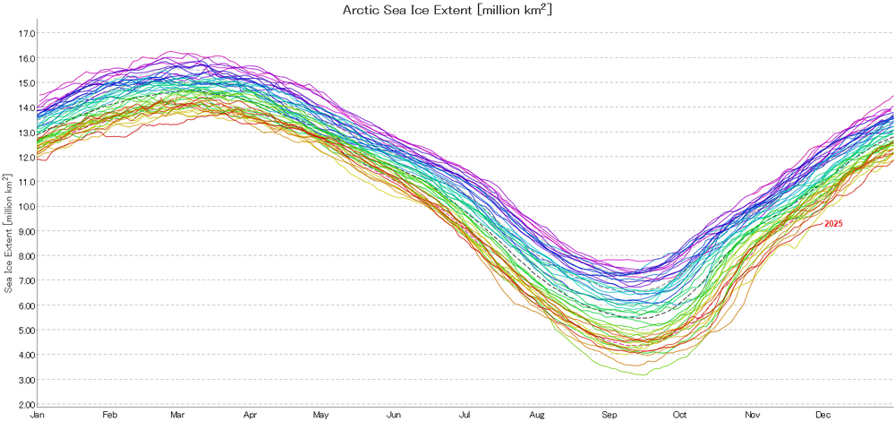
-
As per mPING, the precipitation has started as rain in New York City and southern Westchester County. North of White Plains, there was a rain/snow mixture.
-
According to NWS data, the 8 am temperature in the Bronx was 36°. Even as there remains a chance that some snow/sleet could be seen at the onset of the precipitation, no accumulation is likely. As per mPING, the precipitation arrived as light rain in Union, NJ. We'll see whether it briefly flips to sleet/snow upon growing heavier. If not, that's not a good sign for the NYC area.