donsutherland1
-
Posts
24,169 -
Joined
Content Type
Profiles
Blogs
Forums
American Weather
Media Demo
Store
Gallery
Everything posted by donsutherland1
-
This was the CPC forecast:
-
Under bright sunshine amidst some wispy high clouds, temperatures rose into the 70s today. Tomorrow will be even warmer. Temperatures will top out in the upper 70s and lower 80s across much of the region. Newark's record-breaking streak with high temperatures of 70° or above increased to 125 consecutive days. The previous record was 119 days, which was set in 2008. Since Newark first recorded 90 or more such days back in 1900, the record has increased by no more than 7 days over the prior mark. That margin could be surpassed this year. The warm regime will continue through much of next week. There is a chance of a significant rain event late in the week. Overall, the Middle Atlantic and southern New England areas appear to be in line with a warmer to much warmer than normal October (a general 2°-4° above normal). New York City could have an October mean temperature of 60° or above. Out West, Bismarck is in line for one of its 5 warmest opening weeks in October. During that time, Bismarck could challenge or break its record of 4 consecutive 80° high temperatures in October. The record was set during October 3-6, 1879 and tied during October 10-13, 1934. Fall 2021 will likely be wetter to much wetter than normal in the northern Middle Atlantic region. Since 1869, there have been 9 August cases where New York City picked up 20.00" or more rainfall during the summer. Two thirds of those cases (and 4/5 of those with summer mean temperatures of 73.0° or above) had 17.00" or more fall precipitation in New York City. 2011 is probably the closest match in terms of precipitation and a nearly identical summer mean temperature. Mean fall precipitation for those 9 cases was 14.86". The median was 17.35". The 1991-2020 normal value is 12.27". Following very wet July-September periods, winter (December-February) precipitation has typically been near or below normal. The most recent exception was winter 2018-19. The ENSO Region 1+2 anomaly was +0.2°C and the Region 3.4 anomaly was -0.3°C for the week centered around September 22. For the past six weeks, the ENSO Region 1+2 anomaly has averaged +0.05°C and the ENSO Region 3.4 anomaly has averaged -0.43°C. Neutral ENSO conditions will likely yield to La Niña conditions this month. The SOI was +13.54 today. The preliminary Arctic Oscillation (AO) figure was -0.584 today. On September 30 the MJO was in Phase 4 at an amplitude of 1.639 (RMM). The September 29-adjusted amplitude was 1.414 (RMM).
-
The Pacific Northwest dealt with such extremes at the end of June. Maybe this decade will see an extreme heat outbreak here. It will even be scorching hot under the dense foliage at Central Park.
-
Morning at Robert Moses State Park. Readings around 60 at sunrise.
-
Morning thoughts… Today will be partly sunny and noticeably warmer. High temperatures will likely reach the middle and upper 70s in most of the region. Likely high temperatures around the region include: New York City (Central Park): 74° Newark: 78° Philadelphia: 77° Normals: New York City: 30-Year: 69.8°; 15-Year: 71.1° Newark: 30-Year: 71.4°; 15-Year: 72.9° Philadelphia: 30-Year: 72.6°; 15-Year: 73.9° Tomorrow will be another very warm day.
-
It’s really impressive. It’s one of the warmer runs relative to normal over an extended period that I have seen since December 2015.
-
After a chilly start that saw temperatures tumble into the lower 50s in Philadelphia, Newark, and New York City and 40s outside the cities with the coldest locations bottoming out in the 30s, the afternoon warmed into the middle and upper 60s in most areas. Newark's record-breaking streak with high temperatures of 70° or above increased to 124 consecutive days. The previous record was 119 days, which was set in 2008. Since Newark first recorded 90 or more such days back in 1900, the record has increased by no more than 7 days over the prior mark. That margin could be surpassed this year. Tomorrow and Sunday will be unseasonably warm days with temperatures rising well into the 70s. The warm regime will continue next week. However, there is a chance of a significant rain event late in the week. Bismarck could have one of its 5 warmest opening weeks in October. Overall, the Middle Atlantic and southern New England areas appear to be in line with a warmer to much warmer than normal October (a general 2°-4° above normal). New York City could have an October mean temperature of 60° or above. Fall 2021 will likely be wetter to much wetter than normal in the northern Middle Atlantic region. Since 1869, there have been 9 August cases where New York City picked up 20.00" or more rainfall during the summer. Two thirds of those cases (and 4/5 of those with summer mean temperatures of 73.0° or above) had 17.00" or more fall precipitation in New York City. 2011 is probably the closest match in terms of precipitation and a nearly identical summer mean temperature. Mean fall precipitation for those 9 cases was 14.86". The median was 17.35". The 1991-2020 normal value is 12.27". Following very wet July-September periods, winter (December-February) precipitation has typically been near or below normal. The most recent exception was winter 2018-19. The ENSO Region 1+2 anomaly was +0.2°C and the Region 3.4 anomaly was -0.3°C for the week centered around September 22. For the past six weeks, the ENSO Region 1+2 anomaly has averaged +0.05°C and the ENSO Region 3.4 anomaly has averaged -0.43°C. Neutral ENSO conditions will likely yield to La Niña conditions this month. The SOI was +10.76 today. The preliminary Arctic Oscillation (AO) figure was -1.149 today. On September 29 the MJO was in Phase 4 at an amplitude of 1.409 (RMM). The September 28-adjusted amplitude was 1.427 (RMM).
-
The September warming has accelerated in recent years. The 2000-21 mean is 69.6. The 2010-21 mean is 70.4.
-
Morning thoughts... October 2021 got off to a crisp start. Low temperatures included: Allentown: 42° Bridgeport: 50° Danbury: 42° Islip: 49° New York City: 51° Newark: 52° Philadelphia: 50° Westhampton: 37° White Plains: 45° The crisp start masks what will very likely be October 2021's true nature. The month will very likely be warmer to much warmer than normal. New York City could finish with a monthly mean temperature of 60° or above. Today will be partly to mostly sunny and continued cool. Temperatures will likely reach the upper 60s and lower 70s across much of the region. Likely high temperatures include: New York City (Central Park): 68° Newark: 72° Philadelphia: 72° Warmer air will arrive for the weekend. Normals: New York City: 30-Year: 70.2°; 15-Year: 71.5° Newark: 30-Year: 71.8°; 15-Year: 73.3° Philadelphia: 30-Year: 73.0°; 15-Year: 74.3° 30-Day Verification: New York City (Central Park): Average daily forecast: 76.3° Average temperature: 76.3° Average error: 1.1° Newark: Average daily forecast: 80.4° Average temperature: 80.2° Average error: 0.9° Philadelphia: Average daily forecast: 79.8° Average temperature: 80.1° Average error: 1.1°
-
At 2:51 pm, the temperature reached a daily high of 70° at Newark. That extended Newark's record streak with high temperatures of 70° or above to 123 consecutive days. New York City is finishing September with a mean temperature of 70.3° (1.1° above normal). As of 7 pm, that figure is 70.4°, but it is likely to fall to 70.3° as the mercury dips below 58° late this evening. 2021 is the 6th out of the last 7 years during which September has had a mean temperature of 70° or above in New York City. Prior to 2000, New York City saw such warmth on average once every five years. What will likely turn out to be a warm October will start off on a cool note. Temperatures will rebound into the upper 60s and lower 70s during the afternoon. Warmer temperatures will return this weekend. Next week, the chance of precipitation will increase. There is strong consensus on the long-range guidance that October will be an unseasonably warm month. The first half could feature much above normal readings in the Northern Plains into Central Canada. Bismarck could have one of its 5 warmest opening weeks in October on record. Overall, the Middle Atlantic and southern New England areas appear to be in line with a warmer to much warmer than normal October (a general 2°-4° above normal). Fall 2021 will likely be wetter to much wetter than normal in the northern Middle Atlantic region. Since 1869, there have been 9 August cases where New York City picked up 20.00" or more rainfall during the summer. Two thirds of those cases (and 4/5 of those with summer mean temperatures of 73.0° or above) had 17.00" or more fall precipitation in New York City. 2011 is probably the closest match in terms of precipitation and a nearly identical summer mean temperature. Mean fall precipitation for those 9 cases was 14.86". The median was 17.35". The 1991-2020 normal value is 12.27". Following very wet July-September periods, winter (December-February) precipitation has typically been near or below normal. The most recent exception was winter 2018-19. The ENSO Region 1+2 anomaly was +0.2°C and the Region 3.4 anomaly was -0.3°C for the week centered around September 22. For the past six weeks, the ENSO Region 1+2 anomaly has averaged +0.05°C and the ENSO Region 3.4 anomaly has averaged -0.43°C. Neutral ENSO conditions will likely prevail through September. Afterward, La Niña conditions could begin to develop during October. The SOI was +18.25 today. The preliminary Arctic Oscillation (AO) figure was -1.441 today. On September 28 the MJO was in Phase 4 at an amplitude of 1.420 (RMM). The September 27-adjusted amplitude was 1.349 (RMM).
-
The streak goes on... At 4 pm. Newark had a temperature of 70 degrees. The record streak of 70-degree high temperatures is now 123 days.
-
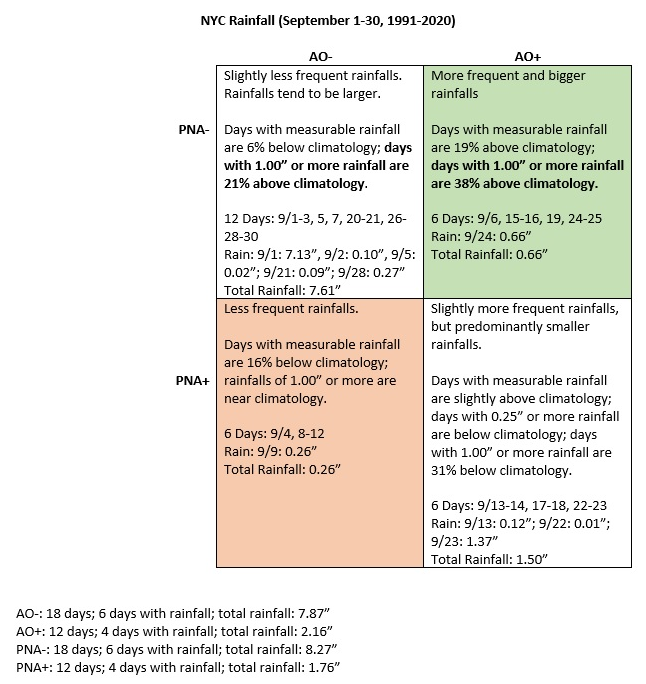
New York City's September rainfall, teleconnections climatology (1991-20 period) and outcomes:
-
October 2021 temperature forecast contest
donsutherland1 replied to Roger Smith's topic in Weather Forecasting and Discussion
DCA _ NYC _ BOS __ ORD _ ATL _ IAH __ DEN _ PHX _ SEA 2.8 3.0 2.8 6.0 2.4 1.6 1.0 -0.1 -0.4 -
Morning thoughts… Today will start off with overcast skies in parts of the region. Those clouds will yield to sunshine. Elsewhere, it will be partly sunny and unseasonably cool. High temperatures will likely reach the middle and upper 60s in most of the region. Likely high temperatures around the region include: New York City (Central Park): 65° Newark: 70° Philadelphia: 70° Normals: New York City: 30-Year: 70.6°; 15-Year: 71.9° Newark: 30-Year: 72.2°; 15-Year: 73.7° Philadelphia: 30-Year: 73.5°; 15-Year: 74.7° Dry but cool weather will continue through tomorrow.
-
Tonight will provide a genuine autumn preview. Temperatures will likely fall into the lower 50s in New York City, Newark, and perhaps Philadelphia. Outside the cities, temperatures could fall well into the 40s. Westhampton could see the mercury dip below 40°. Afterward, it will be variably cloudy with the mercury rising into the middle and upper 60s in much of the region. Newark's record-breaking 122-day streak with maximum temperatures of 70° or above will be severely challenged. Most of the modeling shows a high of 68°-70° there. 2021 is virtually certain to become the 6th out of the last 7 years during which September has had a mean temperature of 70° or above in New York City. Prior to 2000, New York City saw such warmth on average once every five years. In short, September has become more an extension of summer than a gateway to autumn in the New York City area. Friday will be another relatively cool day. But warmer temperatures will return and the chance of precipitation will increase as the calendar presses deeper into the first week of October. There is strong consensus on the long-range guidance that October will be an unseasonably warm month. The first half could feature much above normal readings in the Northern Plains into Central Canada. Overall, the Middle Atlantic and southern New England areas appear to be in line with a warmer to much warmer than normal October (a general 2°-4° above normal). Fall 2021 will likely be wetter to much wetter than normal in the northern Middle Atlantic region. Since 1869, there have been 9 August cases where New York City picked up 20.00" or more rainfall during the summer. Two thirds of those cases (and 4/5 of those with summer mean temperatures of 73.0° or above) had 17.00" or more fall precipitation in New York City. 2011 is probably the closest match in terms of precipitation and a nearly identical summer mean temperature. Mean fall precipitation for those 9 cases was 14.86". The median was 17.35". The 1991-2020 normal value is 12.27". Following very wet July-September periods, winter precipitation has typically been near or below normal. The most recent exception was winter 2018-19. The ENSO Region 1+2 anomaly was +0.2°C and the Region 3.4 anomaly was -0.3°C for the week centered around September 22. For the past six weeks, the ENSO Region 1+2 anomaly has averaged +0.05°C and the ENSO Region 3.4 anomaly has averaged -0.43°C. Neutral ENSO conditions will likely prevail through September. Afterward, La Niña conditions could begin to develop during October. The SOI was +30.49 today. The preliminary Arctic Oscillation (AO) figure was -1.308 today. On September 27 the MJO was in Phase 4 at an amplitude of 1.346 (RMM). The September 26-adjusted amplitude was 1.087 (RMM). Based on sensitivity analysis applied to the latest guidance, there is an implied near 100% probability that New York City will have a warmer than normal September (1991-2020 normal). September will likely finish with a mean temperature near 70.3° (1.1° above normal).
-
I looked at outcomes following high July-September precipitation on fall (September-November) and winter (December-February) precipitation for New York City. Rather than using the full 1869-2020 data set, I used the 1971-2020 data set for two reasons: 1. There has been an abrupt and sustained increase in precipitation after 1970. 1869-1970 average: 42.89". 1971-2020 average: 50.67". The drier region prior to 1971 may no longer be relevant. 2. The 1971-2020 data set is sufficiently large to produce cases for evaluation. To determine "high precipitation" outcomes, I used 0.5 or more sigma above the July-September 1971-2020 average. There were 8 cases that fit that definition: 1971, 1975, 1989, 1990, 2000, 2004, 2011, and 2018. All but 1990 and 2000 were at least 1 sigma above the average. Fall (September-November): 1971-2020 Average: 12.62" 8-Case Subset: 15.74" All but 2 cases were at least 1 sigma above the fall average. Only 1990 and 2000 were slightly below normal (-0.28 sigma and -0.62 sigma). This supports the continuation of above normal precipitation through much of the fall. Following Winter (December-February): 1971-72 through 2020-21 average: 11.29" 8-Case Subset: 10.44" 5 (63%) were within 0.5 sigma of the average 3 (37%) were more than 0.5 sigma below average (1989-90, 2000-01, 2011-12) 1 (13%) were more than 0.5 sigma above average (2018-19) Precipitation amounts did not necessarily impact seasonal snowfall. 2004-05 had 41.0" snowfall with precipitation +0.04 sigma (near normal). 2000-01 had 35.0" snowfall with precipitation -0.94 sigma (much below normal). Winter 2018-19 had 20.5" (precipitation: +0.61 sigma or above normal). Mean snowfall for the subset: 22.8"; median snowfall: 21.7". Excluding the El Niño cases (2004-05 and 2018-19), the mean snowfall was 20.2" and the median snowfall was 20.1".
-
Morning thoughts… Today will be partly sunny and cooler. High temperatures will likely reach the upper 60s and lower 70s in most of the region. Likely high temperatures around the region include: New York City (Central Park): 68° Newark: 73° Philadelphia: 71° Normals: New York City: 30-Year: 71.0°; 15-Year: 72.3° Newark: 30-Year: 72.6°; 15-Year: 74.1° Philadelphia: 30-Year: 73.9°; 15-Year: 75.1° Dry but cool weather will continue through Friday.
-
If I correctly recall the posted message, the letter had been sent and the regional headquarters was going to take a closer look. So far, nothing has changed at the Park.
-
Rainfall totals increased fairly abruptly after 1970.
-
That could mean less snowfall in the winter all other variables notwithstanding.
-
0.27” was the final amount. September will very likely end with 10.03”.
-
I will have a look tonight or tomorrow. I share your concern about drying out, especially if summer and fall are very wet.
-
An area of showers and thundershowers moved through the region late this morning and early this afternoon. A total of 0.27" of rain fell in New York City's Central Park pushing the monthly rainfall total to 10.03". As a result, New York City has seen a record 3 consecutive months with 10" or more of rain. Records go back to 1869. In addition, 10" or more of rain each month from July-September is unprecedented this far north. In 1894 and again in 1945, Downtown Charleston, SC (32.78°N) saw 10" or more of rain during this period. In 1946, Wilmington, NC (34.21°N) saw 10" or more of rain during this period. Then, in 2018, Dunn (4 NW), NC (35.31°N) recorded 10" or more during July, August, and September. Year-to-date rainfall in New York City is now 51.96". That ranks 2021 as New York City's 33rd wettest year on record. In the Northern Plains, today witnessed searing heat. The thermometer topped out at 98° at Bismarck, which surpassed the daily mark of 97° from 1905. This is also the latest 98° or above reading on record. This evening, a few isolated showers and thundershowers are possible in parts of the region, but skies will clear. Tomorrow through Friday will feature plentiful sunshine and cool temperatures. 2021 remains on course to become the 6th out of the last 7 years during which September has had a mean temperature of 70° or above in New York City. Prior to 2000, New York City saw such warmth on average once every five years. In short, September has become more an extension of summer than a gateway to autumn in the New York City area. There is strong consensus on the long-range guidance that October will be an unseasonably warm month. The first half could feature much above normal readings in the Northern Plains into Central Canada. Overall, the Middle Atlantic and southern New England areas appear to be in line with a warmer to much warmer than normal October. Fall 2021 will likely be wetter to much wetter than normal in the northern Middle Atlantic region. Since 1869, there have been 9 August cases where New York City picked up 20.00" or more rainfall during the summer. Two thirds of those cases (and 4/5 of those with summer mean temperatures of 73.0° or above) had 17.00" or more fall precipitation in New York City. 2011 is probably the closest match in terms of precipitation and a nearly identical summer mean temperature. Mean fall precipitation for those 9 cases was 14.86". The median was 17.35". The 1991-2020 normal value is 12.27". The ENSO Region 1+2 anomaly was +0.2°C and the Region 3.4 anomaly was -0.3°C for the week centered around September 22. For the past six weeks, the ENSO Region 1+2 anomaly has averaged +0.05°C and the ENSO Region 3.4 anomaly has averaged -0.43°C. Neutral ENSO conditions will likely prevail through September. Afterward, La Niña conditions could begin to develop during October. The SOI was +36.90 today. The preliminary Arctic Oscillation (AO) figure was -1.474 today. On September 26 the MJO was in Phase 4 at an amplitude of 1.081 (RMM). The September 25-adjusted amplitude was 0.823 (RMM). Based on sensitivity analysis applied to the latest guidance, there is an implied near 100% probability that New York City will have a warmer than normal September (1991-2020 normal). September will likely finish with a mean temperature near 70.3° (1.1° above normal).
-
With 0.25" rain through 12:08 pm, New York City's Central Park has now reached 10.01" rain for September.