

donsutherland1
-
Posts
24,169 -
Joined
Content Type
Profiles
Blogs
Forums
American Weather
Media Demo
Store
Gallery
Everything posted by donsutherland1
-
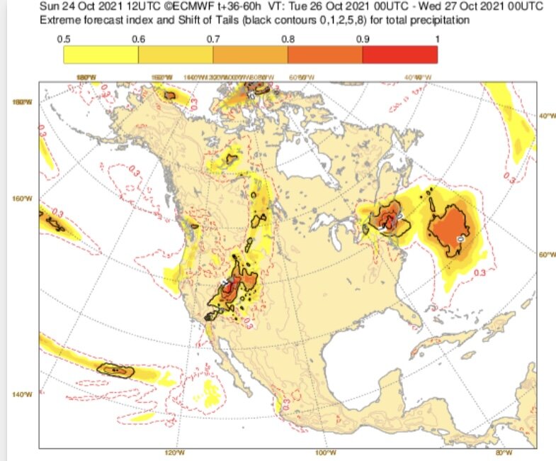
Ahead of a major storm that will bring a widespread 2"-4" rainfall with local amounts of 6" to the region, temperatures rose into the 70s across much of the region. Several locations reached or exceeded daily record high temperatures including: Baltimore: 80° (old record: 77°, 1975 and 1931) Philadelphia: 78° (old record: 76°, 1993, 2001, and 2010) Sterling, VA: 80° (old record: 77°, 1963) Washington, DC: 80° (tied record set in 1902) Newark reached 70° for the 175th time this year. The old record was 173 days, which was set in 2010. Four of the five years that saw 170 or more such days have occurred since 2000 and three have occurred since 2010. Through 4 pm today, New York City has picked up 52.54" of rain. As a result, 2021 currently ranks as New York City's 31st wettest year on record. By the end of this week, following a second storm, 2021 will very likely rank among New York City's 20 wettest years on record. No sharp cold shots appear likely through the remainder of October. The following locations are on course to challenge or establish new record high lowest monthly temperatures for October (through October 25 4 pm): Bridgeport: 43° (record: 41°, 2004) Buffalo: 42° (record: 39°, 1971) Islip: 42° (record: 40°, 1971 and 2017) New York City-JFK: 47° (record: 46°, 1971) New York City-LGA: 51° (record: 47°, 1971) New York City-NYC: 47° (record: 45°, 1946 and 1971) Newark: 45° (record: 45°, 1971) Philadelphia: 46° (record: 45°, 1882, 1927 and 1931) Poughkeepsie: 36° (record: 35°, 1971, 1995 and 1996) White Plains: 41° (record: 40°, 1971) In northern Maine, Caribou experienced its first freeze of the season earlier today. The prior record latest first freeze occurred on October 17, 1970. The normal first freeze (1991-2020) occurs on September 25th, which was an increase of 2 days over the prior 1981-2010 base period. The MJO had completed its passage through Phase 5 at a very high amplitude during the first half of October. During the 1991-2020 period, there were 6 cases with passage through Phase 5 with at least three days at an amplitude of 1.500 or above: 1998, 2000, 2004, 2010, 2017, and 2020. There was a strong signal for the second half of October to wind up warmer than normal (83%) cases in the New York City area. However, that signal broke down to a 50-50 split for the first 10 days of November. That hints at possible timing for a pattern transition depending on the pattern evolution and changes in the teleconnections. However, there is a chance that one could warmth return after a cooler than normal to near normal first week of November. The October 22-24 period saw a rare case where the AO was +0.75 or above while the NAO was -0.75 or below. There have been only 9 prior days during the second half of October (1950-2020), comprising just 0.8% of the period. Those days occurred during 1961, 1970, 1973, 1975, 2006, and 2008. In five of those six years, the first half of November saw warm anomalies in the Northeast. More than likely, the first half of November will wind up cooler than normal despite the above statistical data. Fall 2021 will likely be wetter to much wetter than normal in the northern Middle Atlantic region. Since 1869, there have been 9 August cases where New York City picked up 20.00" or more rainfall during the summer. Two thirds of those cases (and 4/5 of those with summer mean temperatures of 73.0° or above) had 17.00" or more fall precipitation in New York City. 2011 is probably the closest match in terms of precipitation and a nearly identical summer mean temperature. Mean fall precipitation for those 9 cases was 14.86". The median was 17.35". The 1991-2020 normal value is 12.27". Following very wet July-September periods, winter (December-February) precipitation has typically been near or below normal. The most recent exception was winter 2018-19. The ENSO Region 1+2 anomaly was -0.7°C and the Region 3.4 anomaly was -0.8°C for the week centered around October 20. For the past six weeks, the ENSO Region 1+2 anomaly has averaged +0.05°C and the ENSO Region 3.4 anomaly has averaged -0.52°C. La Niña conditions will likely persist through at least mid-winter. The SOI was -6.38 today. The preliminary Arctic Oscillation (AO) figure was +0.899 today. On October 23 the MJO was in Phase 2 at an amplitude of 0.783 (RMM). The October 22-adjusted amplitude was 0.602 (RMM). Based on sensitivity analysis applied to the latest guidance, there is an implied near 100% probability that New York City will have a warmer than normal October (1991-2020 normal). October will likely finish with a mean temperature near 61.9° (4.0° above normal).
-
I’ve heard unofficial estimates of 4-5 feet, but haven’t seen concrete numbers.
-
Morning thoughts… Caribou finally saw the temperature fall to 32° this morning. That is the latest first freeze on record. The prior record was October 17, 1970. Yesterday, Sacramento picked up an all-time daily record rainfall of 5.41” and San Francisco picked up an autumn record and 3rd highest daily rainfall of 4.02”. Today will mostly cloudy and very warm. High temperatures will likely reach the lower and middle 70s in most of the region. Likely high temperatures around the region include: New York City (Central Park): 71° Newark: 75° Philadelphia: 76° Normals: New York City: 30-Year: 61.2°; 15-Year: 61.6° Newark: 30-Year: 62.7°; 15-Year: 63.4° Philadelphia: 30-Year: 63.8°; 15-Year: 64.0° A storm will bring a widespread 2”-4” rainfall with locally higher amounts tomorrow into Wednesday.
-
The EPS is increasingly suggesting the potential for a high-end rainfall in and around the NYC Metro Area:
- 306 replies
-
- 4
-

-
- heavy rain
- damaging wind
- (and 1 more)
-
A warm front is pushing across the region. As a result, tomorrow will see brief surge of unseasonable warmth ahead of what will become a stormy pattern. Readings will likely reach the lower and middle 70s in many parts of the region. The warmest spots could see temperatures rise into the upper 70s. Tuesday and again later in the week, storms could bring a significant rainfall to parts of the region. The first storm could bring a general 1.50"-3.50" of rain to much of the region on Tuesday into Wednesday with locally higher amounts. With 52.48" of rain through October 24th, 2021 ranks as New York City's 31st wettest year on record. By the end of this week, 2021 will likely rank as among New York City's 20 wettest years on record. No sharp cold shots appear likely through the remainder of October. Out West, a powerful storm is bringing high winds and heavy rains to northern California into parts of Nevada. As of 5 pm, rainfall totals include: Redding, CA: 2.91" (old record: 2.29", 2010) Reno: 0.90" (old record: 0.86", 1951) Sacramento: 2.42" (old record: 1.08", 2010) The following locations are on course to challenge or establish new record high lowest monthly temperatures for October (through October 24 4 pm): Bridgeport: 43° (record: 41°, 2004) Buffalo: 42° (record: 39°, 1971) Islip: 42° (record: 40°, 1971 and 2017) New York City-JFK: 47° (record: 46°, 1971) New York City-LGA: 51° (record: 47°, 1971) New York City-NYC: 47° (record: 45°, 1946 and 1971) Newark: 46° (record: 45°, 1971) Philadelphia: 46° (record: 45°, 1882, 1927 and 1931) Poughkeepsie: 36° (record: 35°, 1971, 1995 and 1996) White Plains: 41° (record: 40°, 1971) In northern Maine, Caribou has yet to experience its first freeze of autumn. The prior record latest first freeze occurred on October 17, 1970. The normal first freeze (1991-2020) occurs on September 25th, which was an increase of 2 days over the prior 1981-2010 base period. The MJO had completed its passage through Phase 5 at a very high amplitude during the first half of October. During the 1991-2020 period, there were 6 cases with passage through Phase 5 with at least three days at an amplitude of 1.500 or above: 1998, 2000, 2004, 2010, 2017, and 2020. There was a strong signal for the second half of October to wind up warmer than normal (83%) cases in the New York City area. However, that signal broke down to a 50-50 split for the first 10 days of November. That hints at possible timing for a pattern transition depending on the pattern evolution and changes in the teleconnections. However, there is a chance that one could warmth return after a cooler than normal to near normal first week of November. The October 22-24 period saw a rare case where the AO was +0.75 or above while the NAO was -0.75 or below. There have been only 9 prior days during the second half of October (1950-2020), comprising just 0.8% of the period. Those days occurred during 1961, 1970, 1973, 1975, 2006, and 2008. In five of those six years, the first half of November saw warm anomalies in the Northeast. Fall 2021 will likely be wetter to much wetter than normal in the northern Middle Atlantic region. Since 1869, there have been 9 August cases where New York City picked up 20.00" or more rainfall during the summer. Two thirds of those cases (and 4/5 of those with summer mean temperatures of 73.0° or above) had 17.00" or more fall precipitation in New York City. 2011 is probably the closest match in terms of precipitation and a nearly identical summer mean temperature. Mean fall precipitation for those 9 cases was 14.86". The median was 17.35". The 1991-2020 normal value is 12.27". Following very wet July-September periods, winter (December-February) precipitation has typically been near or below normal. The most recent exception was winter 2018-19. The ENSO Region 1+2 anomaly was -0.2°C and the Region 3.4 anomaly was -0.8°C for the week centered around October 13. For the past six weeks, the ENSO Region 1+2 anomaly has averaged +0.15°C and the ENSO Region 3.4 anomaly has averaged -0.43°C. La Niña conditions will likely persist through at least mid-winter. The SOI was -21.08 today. The preliminary Arctic Oscillation (AO) figure was +0.938 today. On October 22 the MJO was in Phase 2 at an amplitude of 0.605 (RMM). The October 21-adjusted amplitude was 0.427 (RMM). Based on sensitivity analysis applied to the latest guidance, there is an implied near 100% probability that New York City will have a warmer than normal October (1991-2020 normal). October will likely finish with a mean temperature near 62.0° (4.1° above normal).
-
Caribou’s lowest temperature so far this fall is 33, which occurred on October 5.
-
Morning thoughts… After the coolest morning so far this season in many parts of the region, it will mostly partly cloudy with near seasonable temperatures. High temperatures will likely reach the upper 50s and lower 60s in most of the region. Likely high temperatures around the region include: New York City (Central Park): 59° Newark: 63° Philadelphia: 62° Normals: New York City: 30-Year: 61.6°; 15-Year: 62.0° Newark: 30-Year: 63.0°; 15-Year: 63.8° Philadelphia: 30-Year: 64.2°; 15-Year: 64.5° Tomorrow will be much warmer ahead of a significant rainfall. Out West, a bomb cyclone and atmospheric river will result in record rainfall at Sacramento and parts of northern California. Select daily rainfall records: Downtown Sacramento: October 24 record: 1.21”, 2010 October daily record: 3.63”, October 13, 1962 All-time daily record: 5.28”, April 20, 1880 Sacramento: October 24 record: 1.08”, 2010 October daily record: 3.77”, October 13, 1962 All-time daily record: 3.77”, October 13, 1962
-
Under mostly cloudy skies with some late-day sunshine, the temperature rose only into the upper 50s and lower 60s. Tomorrow will feature more sunshine, and it will be a bit milder. Monday will see brief surge of warmth ahead of what will become a stormy pattern. Tuesday and again later in the week, storms could bring a significant rainfall to parts of the region. The first storm could bring a general 1"-3" of rain to much of the region on Tuesday into Wednesday. No sharp cold shots appear likely through the remainder of October. The following locations are on course to challenge or establish new record high lowest monthly temperatures for October (through October 21): Allentown: 40° (record: 38°, 1971) Boston: 46° (record: 45°, 1971) Bridgeport: 43° (record: 41°, 2004) Islip: 42° (record: 40°, 1971 and 2017) New York City-JFK: 48° (record: 46°, 1971) New York City-LGA: 51° (record: 47°, 1971) New York City-NYC: 47° (record: 45°, 1946 and 1971) Newark: 46° (record: 45°, 1971) Philadelphia: 46° (record: 45°, 1882, 1927 and 1931) Poughkeepsie: 38° (record: 35°, 1971, 1995 and 1996) White Plains: 44° (record: 40°, 1971) In northern Maine, Caribou has yet to experience its first freeze of autumn. The prior record latest first freeze occurred on October 17, 1970. The normal first freeze (1991-2020) occurs on September 25th, which was an increase of 2 days over the prior 1981-2010 base period. The MJO had completed its passage through Phase 5 at a very high amplitude during the first half of October. During the 1991-2020 period, there were 6 cases with passage through Phase 5 with at least three days at an amplitude of 1.500 or above: 1998, 2000, 2004, 2010, 2017, and 2020. There was a strong signal for the second half of October to wind up warmer than normal (83%) cases in the New York City area. However, that signal broke down to a 50-50 split for the first 10 days of November. That hints at possible timing for a pattern transition depending on the pattern evolution and changes in the teleconnections. Fall 2021 will likely be wetter to much wetter than normal in the northern Middle Atlantic region. Since 1869, there have been 9 August cases where New York City picked up 20.00" or more rainfall during the summer. Two thirds of those cases (and 4/5 of those with summer mean temperatures of 73.0° or above) had 17.00" or more fall precipitation in New York City. 2011 is probably the closest match in terms of precipitation and a nearly identical summer mean temperature. Mean fall precipitation for those 9 cases was 14.86". The median was 17.35". The 1991-2020 normal value is 12.27". Following very wet July-September periods, winter (December-February) precipitation has typically been near or below normal. The most recent exception was winter 2018-19. The ENSO Region 1+2 anomaly was -0.2°C and the Region 3.4 anomaly was -0.8°C for the week centered around October 13. For the past six weeks, the ENSO Region 1+2 anomaly has averaged +0.15°C and the ENSO Region 3.4 anomaly has averaged -0.43°C. La Niña conditions will likely persist through at least mid-winter. The SOI was -22.18 today. The preliminary Arctic Oscillation (AO) figure was +1.087 today. On October 21 the MJO was in Phase 2 at an amplitude of 0.433 (RMM). The October 20-adjusted amplitude was 0.498 (RMM). Based on sensitivity analysis applied to the latest guidance, there is an implied near 100% probability that New York City will have a warmer than normal October (1991-2020 normal). October will likely finish with a mean temperature near 62.0° (4.1° above normal).
-
As the sun broke through the clouds, the mercury pushed toward 60 degrees. There are now growing hints of the seasonal progression despite the unseasonable warmth that has defined much of autumn so far.

-
If Caribou makes it through tonight and tomorrow night without a freeze (models show 33-35), it could see its first freeze in November. Record late first freezes: Mount Pocono: November 1, 1920 Scranton: November 15, 1946
-
Seeing the 10” at Portland is a good reminder that some of Portland’s biggest rainstorms have occurred in October, including the October 20-22, 1996 storm that dumped 14.67” of rain in three days, including 11.74” on October 21st.
- 306 replies
-
- 3
-
-
- heavy rain
- damaging wind
- (and 1 more)
-
Morning thoughts… It will mostly cloudy and noticeably cooler. High temperatures will likely reach the upper 50s and lower 60s in most of the region. Likely high temperatures around the region include: New York City (Central Park): 58° Newark: 63° Philadelphia: 63° Normals: New York City: 30-Year: 61.9°; 15-Year: 62.4° Newark: 30-Year: 63.4°; 15-Year: 64.2° Philadelphia: 30-Year: 64.5°; 15-Year: 64.9° Tomorrow will be another cool day.
-
Cooler air is now spreading across the region. Earlier, temperatures topped out in the upper 60s and lower 70s. Newark reached 70° for the 174th time this year. That broke the record set in 2010. Four of the five years that saw 170 or more such days have occurred since 2000 and three have occurred since 2010. A seasonably cool weekend lies ahead. Early next week and again later in the week, storms could bring a moderate to significant rainfall to parts of the region. No sharp cold shots appear likely through the remainder of October. The following locations are on course to challenge or establish new record high lowest monthly temperatures for October (through October 21): Allentown: 40° (record: 38°, 1971) Boston: 46° (record: 45°, 1971) Bridgeport: 43° (record: 41°, 2004) Islip: 42° (record: 40°, 1971 and 2017) New York City-JFK: 48° (record: 46°, 1971) New York City-LGA: 51° (record: 47°, 1971) New York City-NYC: 47° (record: 45°, 1946 and 1971) Newark: 46° (record: 45°, 1971) Philadelphia: 46° (record: 45°, 1882, 1927 and 1931) Poughkeepsie: 38° (record: 35°, 1971, 1995 and 1996) White Plains: 44° (record: 40°, 1971) In northern Maine, Caribou has yet to experience its first freeze of autumn. The prior record latest first freeze occurred on October 17, 1970. The normal first freeze (1991-2020) occurs on September 25th, which was an increase of 2 days over the prior 1981-2010 base period. The MJO had completed its passage through Phase 5 at a very high amplitude during the first half of October. During the 1991-2020 period, there were 6 cases with passage through Phase 5 with at least three days at an amplitude of 1.500 or above: 1998, 2000, 2004, 2010, 2017, and 2020. There was a strong signal for the second half of October to wind up warmer than normal (83%) cases in the New York City area. However, that signal broke down to a 50-50 split for the first 10 days of November. That hints at possible timing for a pattern transition depending on the pattern evolution and changes in the teleconnections. Fall 2021 will likely be wetter to much wetter than normal in the northern Middle Atlantic region. Since 1869, there have been 9 August cases where New York City picked up 20.00" or more rainfall during the summer. Two thirds of those cases (and 4/5 of those with summer mean temperatures of 73.0° or above) had 17.00" or more fall precipitation in New York City. 2011 is probably the closest match in terms of precipitation and a nearly identical summer mean temperature. Mean fall precipitation for those 9 cases was 14.86". The median was 17.35". The 1991-2020 normal value is 12.27". Following very wet July-September periods, winter (December-February) precipitation has typically been near or below normal. The most recent exception was winter 2018-19. The ENSO Region 1+2 anomaly was -0.2°C and the Region 3.4 anomaly was -0.8°C for the week centered around October 13. For the past six weeks, the ENSO Region 1+2 anomaly has averaged +0.15°C and the ENSO Region 3.4 anomaly has averaged -0.43°C. La Niña conditions will likely persist through at least mid-winter. The SOI was +6.25 today. The preliminary Arctic Oscillation (AO) figure was +0.953 today. On October 20 the MJO was in Phase 1 at an amplitude of 0.504 (RMM). The October 19-adjusted amplitude was 0.337 (RMM). Based on sensitivity analysis applied to the latest guidance, there is an implied near 100% probability that New York City will have a warmer than normal October (1991-2020 normal). October will likely finish with a mean temperature near 62.0° (4.1° above normal).
-
Morning thoughts… It will partly sunny and still warm. High temperatures will likely reach the upper 60s and 70s in most of the region. Likely high temperatures around the region include: New York City (Central Park): 68° Newark: 72° Philadelphia: 68° Normals: New York City: 30-Year: 62.3°; 15-Year: 62.8° Newark: 30-Year: 63.7°; 15-Year: 64.6° Philadelphia: 30-Year: 64.9°; 15-Year: 65.3° A cooler weekend lies ahead.
-
That’s been a persistent theme. It may have something to do with the exceptionally warm SSTs off the northeastern U.S. and eastern Canada.
-
Brilliant sunshine provided for another unseasonably warm October day. Temperatures soared well into the 70s across the region. Newark reached 70° for the 173rd time this year. That tied the record set in 2010. Four of the five years that saw 170 or more such days have occurred since 2000 and three have occurred since 2010. Tomorrow will be a bit cooler but still unseasonably warm. A more seasonably cool weekend lies ahead. Early next week and again later in the week, storms could bring a moderate to significant rainfall to parts of the region. No sharp cold shots appear likely through the remainder of October. The following locations are on course to challenge or establish new record high lowest monthly temperatures for October (through October 20): Allentown: 40° (record: 38°, 1971) Boston: 46° (record: 45°, 1971) Bridgeport: 43° (record: 41°, 2004) Islip: 42° (record: 40°, 1971 and 2017) New York City-JFK: 48° (record: 46°, 1971) New York City-LGA: 51° (record: 47°, 1971) New York City-NYC: 47° (record: 45°, 1971) Newark: 46° (record: 45°, 1971) Philadelphia: 46° (record: 45°, 1882, 1927 and 1931) Poughkeepsie: 38° (record: 35°, 1971, 1995 and 1996) White Plains: 44° (record: 40°, 1971) In northern Maine, Caribou has yet to experience its first freeze of autumn. The prior record latest first freeze occurred on October 17, 1970. The normal first freeze (1991-2020) occurs on September 25th, which was an increase of 2 days over the prior 1981-2010 base period. The MJO has now completed its passage through Phase 5 at a very high amplitude. During the 1991-2020 period, there were 6 cases with passage through Phase 5 with at least three days at an amplitude of 1.500 or above: 1998, 2000, 2004, 2010, 2017, and 2020. There was a strong signal for the second half of October to wind up warmer than normal (83%) cases in the New York City area. However, that signal broke down to a 50-50 split for the first 10 days of November. That hints at possible timing for a pattern transition depending on the pattern evolution and changes in the teleconnections. Fall 2021 will likely be wetter to much wetter than normal in the northern Middle Atlantic region. Since 1869, there have been 9 August cases where New York City picked up 20.00" or more rainfall during the summer. Two thirds of those cases (and 4/5 of those with summer mean temperatures of 73.0° or above) had 17.00" or more fall precipitation in New York City. 2011 is probably the closest match in terms of precipitation and a nearly identical summer mean temperature. Mean fall precipitation for those 9 cases was 14.86". The median was 17.35". The 1991-2020 normal value is 12.27". Following very wet July-September periods, winter (December-February) precipitation has typically been near or below normal. The most recent exception was winter 2018-19. The ENSO Region 1+2 anomaly was -0.2°C and the Region 3.4 anomaly was -0.8°C for the week centered around October 13. For the past six weeks, the ENSO Region 1+2 anomaly has averaged +0.15°C and the ENSO Region 3.4 anomaly has averaged -0.43°C. La Niña conditions will likely persist through at least mid-winter. The SOI was +12.18 today. The preliminary Arctic Oscillation (AO) figure was +0.619 today. On October 19 the MJO was in Phase 2 at an amplitude of 0.334 (RMM). The October 18-adjusted amplitude was 0.312 (RMM). Based on sensitivity analysis applied to the latest guidance, there is an implied 99% probability that New York City will have a warmer than normal October (1991-2020 normal). October will likely finish with a mean temperature near 61.8° (3.9° above normal).
-
Ironically, much of the region is competing with 1971 for the highest October minimum temperature.
-
Today will probably be a few degrees cooler.
-
Morning thoughts… It will partly to mostly sunny and unseasonably warm. High temperatures will likely reach the middle and upper 70s in most of the region. Likely high temperatures around the region include: New York City (Central Park): 74° Newark: 79° Philadelphia: 77° Normals: New York City: 30-Year: 62.6°; 15-Year: 63.2° Newark: 30-Year: 64.1°; 15-Year: 65.0° Philadelphia: 30-Year: 65.3°; 15-Year: 65.7° The warm weather will continue through tomorrow, but a cooler weekend lies ahead.
-
Under bright sunshine, the temperature surged into the middle and upper 70s across much of the region. High temperatures included: Bridgeport: 77° (old record: 75°, 1953) Islip: 75° (old record: 74°, 1969, 1979, and 1984) New Haven: 77° (old record: 73°, 1953 and 2017) New York City-JFK: 79° New York City-LGA: 80° (old record: 79°, 1953 and 1984) New York City-NYC: 75° Newark: 80° (tied record set in 1947 and tied in 1969) Philadelphia: 76° White Plains: 74° Newark reached 70° for the 172nd time this year. As a result, 2021 is now has the 2nd most days on record. Today was also Newark's 116th 80° day, which ranks 2nd on the all-time list. Tomorrow and Friday will be unseasonably warm. Another cool shot is likely for the weekend. The MJO has now completed its passage through Phase 5 at a very high amplitude. During the 1991-2020 period, there were 6 cases with passage through Phase 5 with at least three days at an amplitude of 1.500 or above: 1998, 2000, 2004, 2010, 2017, and 2020. There was a strong signal for the second half of October to wind up warmer than normal (83%) cases in the New York City area. However, that signal broke down to a 50-50 split for the first 10 days of November. That hints at possible timing for a pattern transition depending on the pattern evolution and changes in the teleconnections. Fall 2021 will likely be wetter to much wetter than normal in the northern Middle Atlantic region. Since 1869, there have been 9 August cases where New York City picked up 20.00" or more rainfall during the summer. Two thirds of those cases (and 4/5 of those with summer mean temperatures of 73.0° or above) had 17.00" or more fall precipitation in New York City. 2011 is probably the closest match in terms of precipitation and a nearly identical summer mean temperature. Mean fall precipitation for those 9 cases was 14.86". The median was 17.35". The 1991-2020 normal value is 12.27". Following very wet July-September periods, winter (December-February) precipitation has typically been near or below normal. The most recent exception was winter 2018-19. The ENSO Region 1+2 anomaly was -0.2°C and the Region 3.4 anomaly was -0.8°C for the week centered around October 13. For the past six weeks, the ENSO Region 1+2 anomaly has averaged +0.15°C and the ENSO Region 3.4 anomaly has averaged -0.43°C. La Niña conditions will likely persist through at least mid-winter. The SOI was +6.70 today. The preliminary Arctic Oscillation (AO) figure was +0.151 today. On October 18 the MJO was in Phase 2 at an amplitude of 0.315 (RMM). The October 17-adjusted amplitude was 0.375 (RMM). Based on sensitivity analysis applied to the latest guidance, there is an implied 98% probability that New York City will have a warmer than normal October (1991-2020 normal). October will likely finish with a mean temperature near 61.7° (3.8° above normal).
-
Bridgeport and New Haven have also set new records. LGA has tied its record.
-
Morning thoughts… It will partly to mostly sunny and unseasonably warm. High temperatures will likely reach the middle and upper 70s in most of the region. Likely high temperatures around the region include: New York City (Central Park): 76° Newark: 80° Philadelphia: 78° Normals: New York City: 30-Year: 62.9°; 15-Year: 63.6° Newark: 30-Year: 64.4°; 15-Year: 65.4° Philadelphia: 30-Year: 65.6°; 15-Year: 66.1° The warm weather will continue through Friday.
-
After a chilly start, temperatures moderated under strong sunshine. Highs generally reached the middle and upper 60s across the region. Newark reached 70° for the 171st time this year. As a result, 2021 is now tied with 1985 and 2015 for the 2nd most days on record. Warmer air will return tomorrow. Tomorrow through Friday will be unseasonably warm. Another cool shot is likely for the weekend. The MJO has now completed its passage through Phase 5 at a very high amplitude. During the 1991-2020 period, there were 6 cases with passage through Phase 5 with at least three days at an amplitude of 1.500 or above: 1998, 2000, 2004, 2010, 2017, and 2020. There was a strong signal for the second half of October to wind up warmer than normal (83%) cases in the New York City area. However, that signal broke down to a 50-50 split for the first 10 days of November. That hints at possible timing for a pattern transition depending on the pattern evolution and changes in the teleconnections. Fall 2021 will likely be wetter to much wetter than normal in the northern Middle Atlantic region. Since 1869, there have been 9 August cases where New York City picked up 20.00" or more rainfall during the summer. Two thirds of those cases (and 4/5 of those with summer mean temperatures of 73.0° or above) had 17.00" or more fall precipitation in New York City. 2011 is probably the closest match in terms of precipitation and a nearly identical summer mean temperature. Mean fall precipitation for those 9 cases was 14.86". The median was 17.35". The 1991-2020 normal value is 12.27". Following very wet July-September periods, winter (December-February) precipitation has typically been near or below normal. The most recent exception was winter 2018-19. The ENSO Region 1+2 anomaly was -0.2°C and the Region 3.4 anomaly was -0.8°C for the week centered around October 13. For the past six weeks, the ENSO Region 1+2 anomaly has averaged +0.15°C and the ENSO Region 3.4 anomaly has averaged -0.43°C. La Niña conditions will likely persist through at least mid-winter. The SOI was +15.47 today. The preliminary Arctic Oscillation (AO) figure was -0.595 today. On October 17 the MJO was in Phase 5 at an amplitude of 0.374 (RMM). The October 16-adjusted amplitude was 0.594 (RMM). Based on sensitivity analysis applied to the latest guidance, there is an implied 96% probability that New York City will have a warmer than normal October (1991-2020 normal). October will likely finish with a mean temperature near 61.6° (3.7° above normal).
-
The sample size is really small. 1970-71 and 1973-74 were fairly cold, but not severely cold.
-
I didn’t see that in your comment. I’ll look into such winters and post what I find.
