donsutherland1
-
Posts
24,103 -
Joined
Content Type
Profiles
Blogs
Forums
American Weather
Media Demo
Store
Gallery
Everything posted by donsutherland1
-
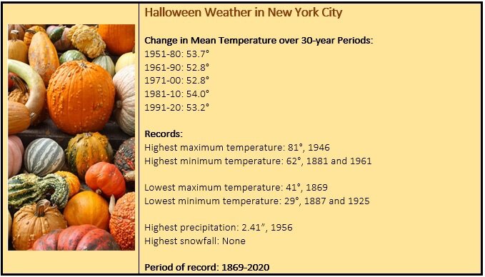
New Haven and Newark are concluding their warmest October on record.
-
An unseasonably warm October is concluding with an unseasonably warm Halloween Day. October will finish with a mean temperature of 62.0° (4.1° above normal) in New York City. Numerous locations in the region saw their warmest monthly minimum temperature on record for November. Those locations included: Atlantic City: 41° (old record: 40°, 2004) Bangor: 35° (old record: 34°, 1968 and 1989) Bridgeport: 43° (old record: 41°, 2004) Harrisburg: 43° (tied record set in 1984) Islip: 42° (old record: 40°, 1971 and 2017) Mount Pocono, PA: 35° (old record: 34°, 1920) New Haven: 42° (old record: 39°, 2014) New York City-JFK: 47° (old record: 46°, 1971) New York City-LGA: 49° (old record: 47°, 1971) New York City-NYC: 47° (old record: 45°, 1946 and 1971) Newark: 45° (tied record set in 1971) Philadelphia: 46° (old record: 45°, 1882, 1927 and 1931) Providence: 41° (old record: 39°, 1971) Scranton: 38° (old record: 36°, 1971) Sterling, VA: 39° (old record: 37°, 1971) Syracuse: 36° (tied record set in 1971) Washington, DC: 47° (old record: 46°, 1971 and 1984) Wilmington, DE: 43° (old record: 41°, 1971) It will turn cooler, but not exceptionally cold, during the first week of November. The duration of the cooler weather remains uncertain. There is an increasing probability that a warming trend could commence during the second week of November. Overall, November will more likely than not average somewhat below normal to near normal in much of the region. The MJO had completed its passage through Phase 5 at a very high amplitude during the first half of October. During the 1991-2020 period, there were 6 cases with passage through Phase 5 with at least three days at an amplitude of 1.500 or above: 1998, 2000, 2004, 2010, 2017, and 2020. There was a strong signal for the second half of October to wind up warmer than normal (83%) cases in the New York City area. However, that signal broke down to a 50-50 split for the first 10 days of November. The latest guidance suggests that a period of cooler than normal weather could develop during the first week of November. The big issue concerns the duration of the cooler weather. Recently, Atlantic teleconnections went through an unusual combination for the second half of October where the AO was +0.750 or above and the NAO was -0.750 or below for a record four consecutive days during the second half of October. There were three clusters of cases with one or more such days during the second half of October (1950-2020), two of which favored warmth in the East in November. Cluster 1 (1961, 1973, 1975): Warm East, Cool West Cluster 2 (1970, 2006): Warm Northeast/Cool Southeast, Warm West Cluster 3 (2008): Cool East, Warm West The October 1-25 North American temperature anomalies most closely resemble those for the Cluster 1 October composite anomalies. The latest CFSv2 monthly forecast favors the Cluster 2 scenario. As a result, even as La Niña climatology would favor a cool November, more than La Niña is involved. The impact of the rare teleconnections combination suggests the possibility that the month could wind up on the warm side of normal. The evolution of the PNA could be crucial. For both Cluster 1 and 2, the PNA averaged negative during November. For Cluster 3, the PNA averaged above +1.000. For now, this is more theoretical in nature, but it is a plausible scenario. Fall 2021 will likely be wetter to much wetter than normal in the northern Middle Atlantic region. Since 1869, there have been 9 August cases where New York City picked up 20.00" or more rainfall during the summer. Two thirds of those cases (and 4/5 of those with summer mean temperatures of 73.0° or above) had 17.00" or more fall precipitation in New York City. 2011 is probably the closest match in terms of precipitation and a nearly identical summer mean temperature. Mean fall precipitation for those 9 cases was 14.86". The median was 17.35". The 1991-2020 normal value is 12.27". Fall rainfall through October 31 4 pm is 15.29". Following very wet July-September periods, winter (December-February) precipitation has typically been near or below normal. The most recent exception was winter 2018-19. The ENSO Region 1+2 anomaly was -0.7°C and the Region 3.4 anomaly was -0.8°C for the week centered around October 20. For the past six weeks, the ENSO Region 1+2 anomaly has averaged +0.05°C and the ENSO Region 3.4 anomaly has averaged -0.52°C. La Niña conditions will likely persist through at least mid-winter. The SOI was -1.48 today. The preliminary Arctic Oscillation (AO) figure was -0.752 today. On October 29 the MJO was in Phase 1 at an amplitude of 0.983 (RMM). The October 28-adjusted amplitude was 0.879 (RMM).
-
Bright sunshine, a refreshing breeze, and temperatures in the 60s made for anything but a frightening Halloween, at least as far as the weather is concerned.


-
____ DCA _ NYC _ BOS __ ORD _ ATL _ IAH ___ DEN _ PHX _ SEA -0.3 -0.2 0.2 0.5 -0.1 0.2 1.2 1.0 0.2
-
Morning thoughts… Today will become partly sunny. It will be unseasonably mild. High temperatures will likely reach the lower and middle 60s in most of the region. Likely high temperatures around the region include: New York City (Central Park): 63° Newark: 67° Philadelphia: 66° Normals: New York City: 30-Year: 59.2°; 15-Year: 59.4° Newark: 30-Year: 60.5°; 15-Year: 61.0° Philadelphia: 30-Year: 61.6°; 15-Year: 61.6° Cooler air will begin pushing into the region tomorrow.
-
2011, 2012 and 2020 were cold. 2020 had the coldest mean temperature (39.0F) since 1925 and the 2nd coldest on record.
-
Tomorrow will be partly sunny and unseasonably mild. However, cooler weather is on the way. It will turn cooler, but not exceptionally cold, during the first week of November. The duration of the cooler weather remains uncertain. There is an increasing probability that a warming trend could commence during the second week of November. The following locations are on course to challenge or establish new record high lowest monthly temperatures for October (through October 30 4 pm): Bridgeport: 43° (record: 41°, 2004) Islip: 42° (record: 40°, 1971 and 2017) Mount Pocono, PA: 35° (record: 34°, 1920) New York City-JFK: 47° (record: 46°, 1971) New York City-LGA: 49° (record: 47°, 1971) New York City-NYC: 47° (record: 45°, 1946 and 1971) Newark: 45° (record: 45°, 1971) Philadelphia: 46° (record: 45°, 1882, 1927 and 1931) The MJO had completed its passage through Phase 5 at a very high amplitude during the first half of October. During the 1991-2020 period, there were 6 cases with passage through Phase 5 with at least three days at an amplitude of 1.500 or above: 1998, 2000, 2004, 2010, 2017, and 2020. There was a strong signal for the second half of October to wind up warmer than normal (83%) cases in the New York City area. However, that signal broke down to a 50-50 split for the first 10 days of November. The latest guidance suggests that a period of cooler than normal weather could develop during the first week of November. The big issue concerns the duration of the cooler weather. Recently, Atlantic teleconnections went through an unusual combination for the second half of October where the AO was +0.750 or above and the NAO was -0.750 or below for a record four consecutive days during the second half of October. There were three clusters of cases with one or more such days during the second half of October (1950-2020), two of which favored warmth in the East in November. Cluster 1 (1961, 1973, 1975): Warm East, Cool West Cluster 2 (1970, 2006): Warm Northeast/Cool Southeast, Warm West Cluster 3 (2008): Cool East, Warm West The October 1-25 North American temperature anomalies most closely resemble those for the Cluster 1 October composite anomalies. The latest CFSv2 monthly forecast favors the Cluster 2 scenario. As a result, even as La Niña climatology would favor a cool November, more than La Niña is involved. The impact of the rare teleconnections combination suggests the possibility that the month could wind up on the warm side of normal. The evolution of the PNA could be crucial. For both Cluster 1 and 2, the PNA averaged negative during November. For Cluster 3, the PNA averaged above +1.000. For now, this is more theoretical in nature, but it is a plausible scenario. Fall 2021 will likely be wetter to much wetter than normal in the northern Middle Atlantic region. Since 1869, there have been 9 August cases where New York City picked up 20.00" or more rainfall during the summer. Two thirds of those cases (and 4/5 of those with summer mean temperatures of 73.0° or above) had 17.00" or more fall precipitation in New York City. 2011 is probably the closest match in terms of precipitation and a nearly identical summer mean temperature. Mean fall precipitation for those 9 cases was 14.86". The median was 17.35". The 1991-2020 normal value is 12.27". Fall rainfall through October 30 4 pm is 15.21". Following very wet July-September periods, winter (December-February) precipitation has typically been near or below normal. The most recent exception was winter 2018-19. The ENSO Region 1+2 anomaly was -0.7°C and the Region 3.4 anomaly was -0.8°C for the week centered around October 20. For the past six weeks, the ENSO Region 1+2 anomaly has averaged +0.05°C and the ENSO Region 3.4 anomaly has averaged -0.52°C. La Niña conditions will likely persist through at least mid-winter. The SOI was -3.87 today. The preliminary Arctic Oscillation (AO) figure was -0.468 today. On October 28 the MJO was in Phase 1 at an amplitude of 0.878 (RMM). The October 27-adjusted amplitude was 0.847 (RMM). Based on sensitivity analysis applied to the latest guidance, there is an implied near 100% probability that New York City will have a warmer than normal October (1991-2020 normal). October will likely finish with a mean temperature near 62.0° (4.1° above normal).
-
A warmer than normal Halloween will conclude a warm October in which many locations in the region will see their warmest monthly minimum temperatures on record for October.
-
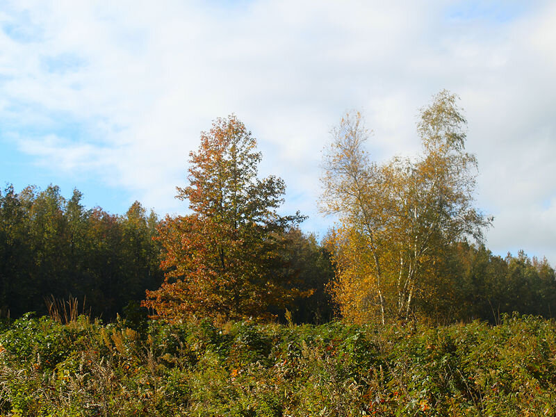
Drier air moving into parts of the region, though not Suffolk County, resulted in several hours of afternoon sunshine and balmy readings. There are growing signs of autumn. But there is also a dissenting opinion from nature.

-
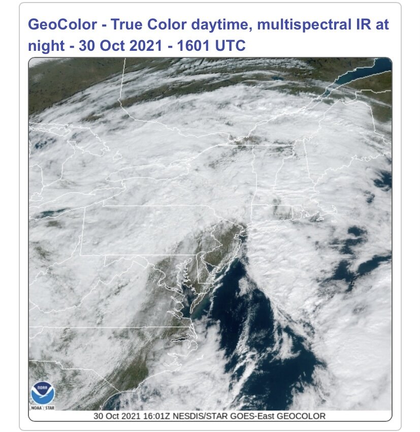
OBS and nowcast now through - 6A Sunday(Halloween) 10/31/21
donsutherland1 replied to wdrag's topic in New York City Metro
Have a great trip. -
OBS and nowcast now through - 6A Sunday(Halloween) 10/31/21
donsutherland1 replied to wdrag's topic in New York City Metro
Dry air is pushing into parts of the region. Several hours of partly or even mostly sunny skies are possible for many parts of New Jersey and parts of southeastern New York State, including Newark and New York City. Newark could make a run at 70 degrees.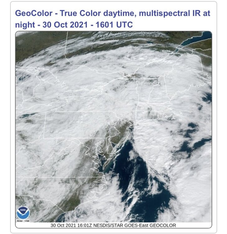
-
Morning thoughts… Through 7 am EDT, New York City had picked up 0.91” of rain from the ongoing system. That brought the annual precipitation figure to 57.11”. As a result, 2021 now ranks as New York City’s 15th wettest year on record. By the time the last rain ends late tonight or early tomorrow, 2021 could be in the 14th position. Today will be cloudy with some additional showers and periods of rain. High temperatures will likely reach the lower and middle 60s in most of the region. Likely high temperatures around the region include: New York City (Central Park): 62° Newark: 67° Philadelphia: 65° Normals: New York City: 30-Year: 59.6°; 15-Year: 59.7° Newark: 30-Year: 60.9°; 15-Year: 61.4° Philadelphia: 30-Year: 62.0°; 15-Year: 62.0° The sun should return tomorrow.
-
OBS and nowcast now through - 6A Sunday(Halloween) 10/31/21
donsutherland1 replied to wdrag's topic in New York City Metro
There was some thunder in Larchmont, NY in southern Westchester County. -
OBS and nowcast now through - 6A Sunday(Halloween) 10/31/21
donsutherland1 replied to wdrag's topic in New York City Metro
Newark is reporting heavy rain and thunder. -
OBS and nowcast now through - 6A Sunday(Halloween) 10/31/21
donsutherland1 replied to wdrag's topic in New York City Metro
From earlier this evening on the Long Island Sound: -
Despite mainly cloudy skies, the chrysanthemums stood out at the New York Botanical Garden.


-
A storm will bring a general 1"-2" of rain with locally higher amounts into tomorrow morning. The remainder of tomorrow will be mostly cloudy with possible additional showers. It will be somewhat milder than today. The remainder of October will see near normal to somewhat above normal readings. It will likely turn cooler, but not exceptionally cold, during the start of November. The duration of the cooler weather remains uncertain. Warming during the second week of November is possible. The following locations are on course to challenge or establish new record high lowest monthly temperatures for October (through October 29 4 pm): Bridgeport: 43° (record: 41°, 2004) Islip: 42° (record: 40°, 1971 and 2017) Mount Pocono, PA: 35° (record: 34°, 1920) New York City-JFK: 47° (record: 46°, 1971) New York City-LGA: 49° (record: 47°, 1971) New York City-NYC: 47° (record: 45°, 1946 and 1971) Newark: 45° (record: 45°, 1971) Philadelphia: 46° (record: 45°, 1882, 1927 and 1931) The MJO had completed its passage through Phase 5 at a very high amplitude during the first half of October. During the 1991-2020 period, there were 6 cases with passage through Phase 5 with at least three days at an amplitude of 1.500 or above: 1998, 2000, 2004, 2010, 2017, and 2020. There was a strong signal for the second half of October to wind up warmer than normal (83%) cases in the New York City area. However, that signal broke down to a 50-50 split for the first 10 days of November. The latest guidance suggests that a period of cooler than normal weather could develop during the first week of November. The big issue concerns the duration of the cooler weather. Recently, Atlantic teleconnections went through an unusual combination for the second half of October where the AO was +0.750 or above and the NAO was -0.750 or below for a record four consecutive days during the second half of October. There were three clusters of cases with one or more such days during the second half of October (1950-2020), two of which favored warmth in the East in November. Cluster 1 (1961, 1973, 1975): Warm East, Cool West Cluster 2 (1970, 2006): Warm Northeast/Cool Southeast, Warm West Cluster 3 (2008): Cool East, Warm West The October 1-25 North American temperature anomalies most closely resemble those for the Cluster 1 October composite anomalies. The latest CFSv2 monthly forecast favors the Cluster 2 scenario. As a result, even as La Niña climatology would favor a cool November, more than La Niña is involved. The impact of the rare teleconnections combination suggests the possibility that the month could wind up on the warm side of normal. The evolution of the PNA could be crucial. For both Cluster 1 and 2, the PNA averaged negative during November. For Cluster 3, the PNA averaged above +1.000. For now, this is more theoretical in nature, but it is a plausible scenario. Fall 2021 will likely be wetter to much wetter than normal in the northern Middle Atlantic region. Since 1869, there have been 9 August cases where New York City picked up 20.00" or more rainfall during the summer. Two thirds of those cases (and 4/5 of those with summer mean temperatures of 73.0° or above) had 17.00" or more fall precipitation in New York City. 2011 is probably the closest match in terms of precipitation and a nearly identical summer mean temperature. Mean fall precipitation for those 9 cases was 14.86". The median was 17.35". The 1991-2020 normal value is 12.27". Fall rainfall through October 29 4 pm is 14.27". Following very wet July-September periods, winter (December-February) precipitation has typically been near or below normal. The most recent exception was winter 2018-19. The ENSO Region 1+2 anomaly was -0.7°C and the Region 3.4 anomaly was -0.8°C for the week centered around October 20. For the past six weeks, the ENSO Region 1+2 anomaly has averaged +0.05°C and the ENSO Region 3.4 anomaly has averaged -0.52°C. La Niña conditions will likely persist through at least mid-winter. The SOI was -3.16 today. The preliminary Arctic Oscillation (AO) figure was +0.461 today. On October 27 the MJO was in Phase 1 at an amplitude of 0.847 (RMM). The October 26-adjusted amplitude was 0.809 (RMM). Based on sensitivity analysis applied to the latest guidance, there is an implied near 100% probability that New York City will have a warmer than normal October (1991-2020 normal). October will likely finish with a mean temperature near 62.0° (4.1° above normal).
-
Occasional Thoughts on Climate Change
donsutherland1 replied to donsutherland1's topic in Climate Change
By itself, it won’t meet the 2030 goal, much less the net zero emissions by 2050 goal, but it is an important downpayment on that effort. It is also a big advance from the status quo or business-as-usual. I hope it will be adopted, and I have already contacted my Senators and Representative. -
Morning thoughts… This morning the temperature fell to 49° at LaGuardia Airport. That was the first time this season that the temperature fell below 50° there and the latest first sub-50° temperature on record. The previous record was October 25, 1946. Clouds will increase and rain will arrive later in the day. A general 1”-2” rainfall with locally higher amounts is likely. High temperatures will likely reach the upper 50s and lower 60s in most of the region. Likely high temperatures around the region include: New York City (Central Park): 56° Newark: 61° Philadelphia: 61° Normals: New York City: 30-Year: 59.9°; 15-Year: 60.1° Newark: 30-Year: 61.2°; 15-Year: 61.8° Philadelphia: 30-Year: 62.3°; 15-Year: 62.4° Rain will end tomorrow but clouds will linger. Drier weather should continue into next week.
-
The brief respite between storms is now ending. Clouds will increase tomorrow as another storm approaches the region. That storm will bring a general 1.00"-2.00" rainfall with locally higher amounts late tomorrow into Saturday. Overall, clouds will increase tomorrow. Temperatures will remain near seasonable levels. No sharp cold shots will occur through the remainder of October. It will likely turn cooler, but not exceptionally cold, during the start of November. The duration of the cooler weather remains uncertain. The following locations are on course to challenge or establish new record high lowest monthly temperatures for October (through October 28 4 pm): Bridgeport: 43° (record: 41°, 2004) Islip: 42° (record: 40°, 1971 and 2017) New York City-JFK: 47° (record: 46°, 1971) New York City-LGA: 50° (record: 47°, 1971) New York City-NYC: 47° (record: 45°, 1946 and 1971) Newark: 45° (record: 45°, 1971) Philadelphia: 46° (record: 45°, 1882, 1927 and 1931) Poughkeepsie: 36° (record: 35°, 1971, 1995 and 1996) White Plains: 41° (record: 40°, 1971) The MJO had completed its passage through Phase 5 at a very high amplitude during the first half of October. During the 1991-2020 period, there were 6 cases with passage through Phase 5 with at least three days at an amplitude of 1.500 or above: 1998, 2000, 2004, 2010, 2017, and 2020. There was a strong signal for the second half of October to wind up warmer than normal (83%) cases in the New York City area. However, that signal broke down to a 50-50 split for the first 10 days of November. The latest guidance suggests that a period of cooler than normal weather could develop during the first or second week of November. The big issue concerns the duration of the cooler weather. Recently, Atlantic teleconnections went through an unusual combination for the second half of October where the AO was +0.750 or above and the NAO was -0.750 or below for a record four consecutive days during the second half of October. There were three clusters of cases with one or more such days during the second half of October (1950-2020), two of which favored warmth in the East in November. Cluster 1 (1961, 1973, 1975): Warm East, Cool West Cluster 2 (1970, 2006): Warm Northeast/Cool Southeast, Warm West Cluster 3 (2008): Cool East, Warm West The October 1-25 North American temperature anomalies most closely resemble those for the Cluster 1 October composite anomalies. As a result, even as La Niña climatology would favor a cool November, more than La Niña is involved. The impact of the rare teleconnections combination suggests the possibility that the month could wind up on the warm side of normal. The evolution of the PNA could be crucial. For both Cluster 1 and 2, the PNA averaged negative during November. For Cluster 3, the PNA averaged above +1.000. For now, this is more theoretical in nature, but it is a plausible scenario. Fall 2021 will likely be wetter to much wetter than normal in the northern Middle Atlantic region. Since 1869, there have been 9 August cases where New York City picked up 20.00" or more rainfall during the summer. Two thirds of those cases (and 4/5 of those with summer mean temperatures of 73.0° or above) had 17.00" or more fall precipitation in New York City. 2011 is probably the closest match in terms of precipitation and a nearly identical summer mean temperature. Mean fall precipitation for those 9 cases was 14.86". The median was 17.35". The 1991-2020 normal value is 12.27". Fall rainfall through October 28 4 pm is 14.27". Following very wet July-September periods, winter (December-February) precipitation has typically been near or below normal. The most recent exception was winter 2018-19. The ENSO Region 1+2 anomaly was -0.7°C and the Region 3.4 anomaly was -0.8°C for the week centered around October 20. For the past six weeks, the ENSO Region 1+2 anomaly has averaged +0.05°C and the ENSO Region 3.4 anomaly has averaged -0.52°C. La Niña conditions will likely persist through at least mid-winter. The SOI was +2.64 today. The preliminary Arctic Oscillation (AO) figure was +1.388 today. On October 26 the MJO was in Phase 1 at an amplitude of 0.810 (RMM). The October 25-adjusted amplitude was 0.710 (RMM). Based on sensitivity analysis applied to the latest guidance, there is an implied near 100% probability that New York City will have a warmer than normal October (1991-2020 normal). October will likely finish with a mean temperature near 62.0° (4.1° above normal).
-
The low temperature at LaGuardia Airport was 50 degrees. So far, the temperature has yet to drop into the 40s. The previous latest first reading in the 40s occurred on October 25, 1946. The normal date is October 6, which is 3 days later than during the prior 1981-2010 base period.
-
Morning thoughts… Today will be partly cloudy and cool. High temperatures will likely reach the upper 50s and lower 60s in most of the region. Likely high temperatures around the region include: New York City (Central Park): 56° Newark: 61° Philadelphia: 62° Normals: New York City: 30-Year: 60.2°; 15-Year: 60.5° Newark: 30-Year: 61.6°; 15-Year: 62.2° Philadelphia: 30-Year: 62.7°; 15-Year: 62.8° A general 1”-2” rainfall with locally higher amounts is likely late tomorrow into Saturday.
-
The storm responsible for a widespread 2"-4" rainfall with some amounts in excess of 6" began moving away from the region today. Clouds broke, but it remained windy throughout the afternoon. In the wake of the storm, New York City's Central Park has received 56.20" of precipitation this year. That makes 2021 New York City's 17th wettest year on record. After a dry but cool day tomorrow, another storm will bring a general 0.50"-1.50" rainfall with locally higher amounts late Friday into Saturday. No sharp cold shots appear likely through the remainder of October. It will likely turn cooler, but not exceptionally cold, during the start of November. The duration of the cooler weather remains uncertain. The following locations are on course to challenge or establish new record high lowest monthly temperatures for October (through October 27 4 pm): Bridgeport: 43° (record: 41°, 2004) Buffalo: 42° (record: 39°, 1971) Islip: 42° (record: 40°, 1971 and 2017) New York City-JFK: 47° (record: 46°, 1971) New York City-LGA: 51° (record: 47°, 1971) New York City-NYC: 47° (record: 45°, 1946 and 1971) Newark: 45° (record: 45°, 1971) Philadelphia: 46° (record: 45°, 1882, 1927 and 1931) Poughkeepsie: 36° (record: 35°, 1971, 1995 and 1996) White Plains: 41° (record: 40°, 1971) The MJO had completed its passage through Phase 5 at a very high amplitude during the first half of October. During the 1991-2020 period, there were 6 cases with passage through Phase 5 with at least three days at an amplitude of 1.500 or above: 1998, 2000, 2004, 2010, 2017, and 2020. There was a strong signal for the second half of October to wind up warmer than normal (83%) cases in the New York City area. However, that signal broke down to a 50-50 split for the first 10 days of November. The latest guidance suggests that a period of cooler than normal weather could develop during the first or second week of November. The big issue concerns the duration of the cooler weather. Recently, Atlantic teleconnections went through an unusual combination for the second half of October where the AO was +0.750 or above and the NAO was -0.750 or below for a record four consecutive days during the second half of October. There were three clusters of cases with one or more such days during the second half of October (1950-2020), two of which favored warmth in the East in November. Cluster 1 (1961, 1973, 1975): Warm East, Cool West Cluster 2 (1970, 2006): Warm Northeast/Cool Southeast, Warm West Cluster 3 (2008): Cool East, Warm West The October 1-25 North American temperature anomalies most closely resemble those for the Cluster 1 October composite anomalies. As a result, even as La Niña climatology would favor a cool November, more than La Niña is involved. The impact of the rare teleconnections combination suggests the possibility that the month could wind up on the warm side of normal. The evolution of the PNA could be crucial. For both Cluster 1 and 2, the PNA averaged negative during November. For Cluster 3, the PNA averaged above +1.000. For now, this is more theoretical in nature, but it is a plausible scenario. Fall 2021 will likely be wetter to much wetter than normal in the northern Middle Atlantic region. Since 1869, there have been 9 August cases where New York City picked up 20.00" or more rainfall during the summer. Two thirds of those cases (and 4/5 of those with summer mean temperatures of 73.0° or above) had 17.00" or more fall precipitation in New York City. 2011 is probably the closest match in terms of precipitation and a nearly identical summer mean temperature. Mean fall precipitation for those 9 cases was 14.86". The median was 17.35". The 1991-2020 normal value is 12.27". Fall rainfall through October 27 is 14.27". Following very wet July-September periods, winter (December-February) precipitation has typically been near or below normal. The most recent exception was winter 2018-19. The ENSO Region 1+2 anomaly was -0.7°C and the Region 3.4 anomaly was -0.8°C for the week centered around October 20. For the past six weeks, the ENSO Region 1+2 anomaly has averaged +0.05°C and the ENSO Region 3.4 anomaly has averaged -0.52°C. La Niña conditions will likely persist through at least mid-winter. The SOI was +7.28 today. The preliminary Arctic Oscillation (AO) figure was +1.621 today. On October 25 the MJO was in Phase 2 at an amplitude of 0.709 (RMM). The October 24-adjusted amplitude was 0.762 (RMM). Based on sensitivity analysis applied to the latest guidance, there is an implied near 100% probability that New York City will have a warmer than normal October (1991-2020 normal). October will likely finish with a mean temperature near 62.0° (4.1° above normal).
-
Morning thoughts… Today will become partly cloudy. Winds will gradually subside. High temperatures will likely reach the upper 50s and lower 60s in most of the region. Likely high temperatures around the region include: New York City (Central Park): 58° Newark: 64° Philadelphia: 65° Normals: New York City: 30-Year: 60.6°; 15-Year: 60.9° Newark: 30-Year: 61.9°; 15-Year: 62.6° Philadelphia: 30-Year: 63.1°; 15-Year: 63.2° Another significant rainfall is likely late Friday into Saturday.
-
OBS and nowcast 9PM tonight-8A Wednesday for a general 2-5" rain, isolated 8" possible. 40-60 kt damaging wind likely Tuesday-early Wednesday. Focus for damaging wind and heaviest rain is the I95 corridor to the coasts. Power outages esp CT LI.
donsutherland1 replied to wdrag's topic in New York City Metro
https://forecast.weather.gov/product.php?site=BOX&product=PNS&issuedby=BOX- 228 replies
-
- 2
-

-

-
- heavy rain
- flash flooding
- (and 2 more)