

donsutherland1
-
Posts
23,800 -
Joined
Content Type
Profiles
Blogs
Forums
American Weather
Media Demo
Store
Gallery
Everything posted by donsutherland1
-
Morning thoughts… Today will be mostly cloudy with periods of rain. Moderate to heavy rain is likely across eastern Long Island into eastern New England. High temperatures will likely reach the lower and middle 70s in most of the region. Likely high temperatures around the region include: New York City (Central Park): 72° Newark: 76° Philadelphia: 74° Normals: New York City: 30-Year: 78.7°; 15-Year: 79.0° Newark: 30-Year: 80.2°; 15-Year: 80.6° Philadelphia: 30-Year: 81.3°; 15-Year: 81.5° A warming trend will develop during the weekend.
-
A cold front will cross the region tonight. In doing so, it will bring showers and thunderstorms to parts of the region. Afterward, the front's progression will slow and there is a possibility that parts of the region will see additional rainfall tomorrow. In general, most of the region will likely see 0.50"-1.50" of rain. Some areas, especially northwestern New Jersey and northeastern Pennsylvania could see 2"-3" rainfall amounts. 2"-3" rainfall amounts could also develop across eastern New England. A warming trend will likely develop this weekend. Despite a cooler than normal first 7-10 days, September will likely feature near normal to somewhat warmer than normal temperatures in much of the region. The second half of the month could feature above to perhaps much above normal temperatures. Fall 2021 will likely be wetter to much wetter than normal in the northern Middle Atlantic region. Since 1869, there have been 9 August cases where New York City picked up 20.00" or more rainfall during the summer. Two thirds of those cases (and 4/5 of those with summer mean temperatures of 73.0° or above) had 17.00" or more fall precipitation in New York City. 2011 is probably the closest match in terms of precipitation and a nearly identical summer mean temperature. Mean fall precipitation for those 9 cases was 14.86". The median was 17.35". The 1991-2020 normal value is 12.27". The ENSO Region 1+2 anomaly was -0.2°C and the Region 3.4 anomaly was -0.3°C for the week centered around September 1. For the past six weeks, the ENSO Region 1+2 anomaly has averaged +0.22°C and the ENSO Region 3.4 anomaly has averaged -0.43°C. Neutral ENSO conditions will likely prevail through September. Afterward, La Niña conditions could begin to develop. The SOI was +3.63 today. The preliminary Arctic Oscillation (AO) figure was -0.417 today. On September 6 the MJO was in Phase 4 at an amplitude of 1.097 (RMM). The September 5-adjusted amplitude was 0.914 (RMM). Based on sensitivity analysis applied to the latest guidance, there is an implied 61% probability that New York City will have a warmer than normal September (1991-2020 normal). September will likely finish with a mean temperature near 70.1° (0.9° above normal).
-
Arctic Sea Ice Extent, Area, and Volume
donsutherland1 replied to ORH_wxman's topic in Climate Change
Congratulations on your being published. -
Morning thoughts… Overnight, the model consensus for rainfall from tonight through tomorrow has increased. A widespread 0.50”-1.50” now appears likely with locally higher amounts. The EPS mean now shows 1” in New York City with 43% of members showing 1” or more. The NBE is now up to just over 0.50”. Today will be partly sunny and warm. Clouds will increase later in the day with showers and thunderstorms arriving. High temperatures will likely reach the lower and middle 80s in most of the region. Likely high temperatures around the region include: New York City (Central Park): 81° Newark: 86° Philadelphia: 85° Normals: New York City: 30-Year: 79.0°; 15-Year: 79.0° Newark: 30-Year: 80.5°; 15-Year: 80.8° Philadelphia: 30-Year: 81.6°; 15-Year: 81.8° Tomorrow will be mostly cloudy with some additional rain.
-
Clouds will increase late in the day tomorrow. Showers and thunderstorms are likely overnight into Thursday morning. A general 0.25"-0.75" rainfall is likely. Locally heavier amounts are possible. An area that includes northwestern New Jersey and northeastern Pennsylvania could see 1"-2" of rain. Despite a cooler than normal first 7-10 days, September will likely feature near normal to somewhat warmer than normal temperatures in much of the region. The second half of the month could feature above to perhaps much above normal temperatures. Fall 2021 will likely be wetter to much wetter than normal in the northern Middle Atlantic region. Since 1869, there have been 9 August cases where New York City picked up 20.00" or more rainfall during the summer. Two thirds of those cases (and 4/5 of those with summer mean temperatures of 73.0° or above) had 17.00" or more fall precipitation in New York City. 2011 is probably the closest match in terms of precipitation and a nearly identical summer mean temperature. Mean fall precipitation for those 9 cases was 14.86". The median was 17.35". The 1991-2020 normal value is 12.27". The ENSO Region 1+2 anomaly was -0.2°C and the Region 3.4 anomaly was -0.3°C for the week centered around September 1. For the past six weeks, the ENSO Region 1+2 anomaly has averaged +0.22°C and the ENSO Region 3.4 anomaly has averaged -0.43°C. Neutral ENSO conditions will likely prevail through September. Afterward, La Niña conditions could begin to develop. The SOI was -6.42 today. The preliminary Arctic Oscillation (AO) figure was -0.099 today. On September 5 the MJO was in Phase 3 at an amplitude of 0.913 (RMM). The September 4-adjusted amplitude was 0.714 (RMM). Based on sensitivity analysis applied to the latest guidance, there is an implied 59% probability that New York City will have a warmer than normal September (1991-2020 normal). September will likely finish with a mean temperature near 70.0° (0.8° above normal).
-
Yes. The EC did among the worst jobs. It largely missed the focus of where the heaviest rainfall wound up. It was much too dry.
-
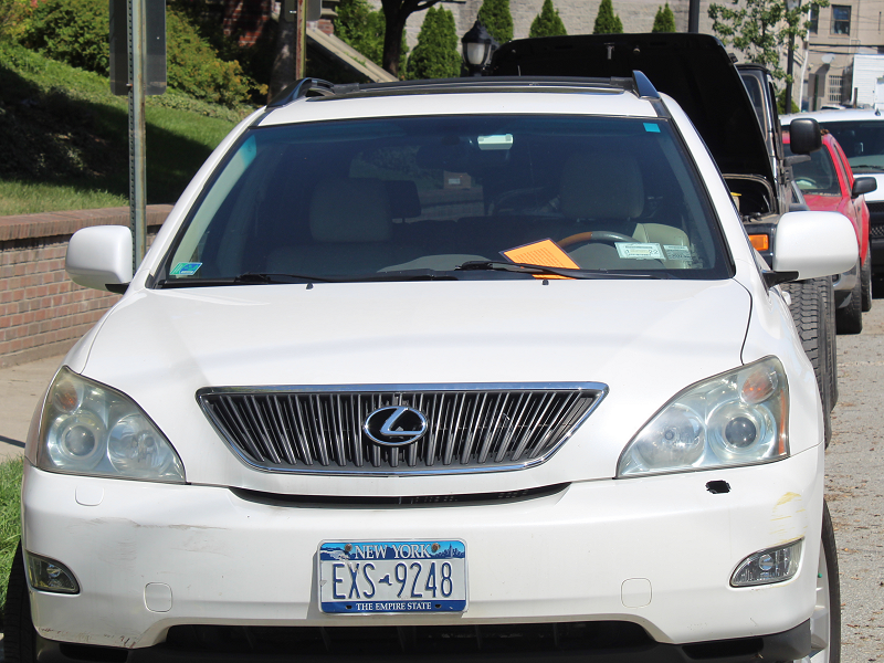
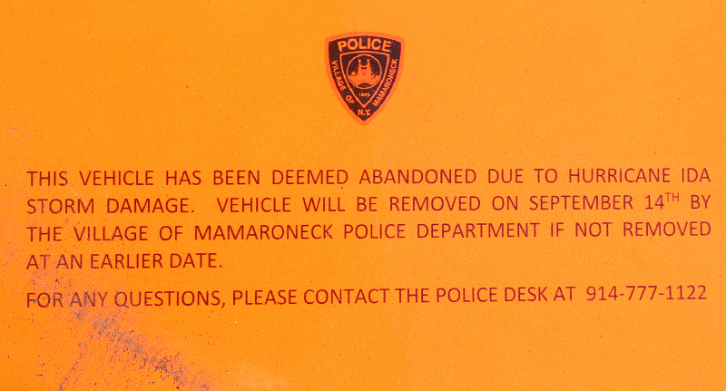
A sad closing chapter to the flood:
-
Arctic Sea Ice Extent, Area, and Volume
donsutherland1 replied to ORH_wxman's topic in Climate Change
The winter-spring Arctic sea ice extent maximum has also been falling, just not as fast as the summer minimum. During the 1990s, the average maximum extent was 15.203 million square kilometers. During the 2010s, the average maximum extent had fallen 6.3% to 14.277 million square kilometers. The 2021 maximum was 14.237 million square kilometers. There has been an average decline of 44,695 square kilometers per year since 1990. The coefficient of determination is 0.700. -
Morning thoughts… Today will be mostly sunny and warm. High temperatures will likely reach the lower 80s in most of the region. Likely high temperatures around the region include: New York City (Central Park): 81° Newark: 84° Philadelphia: 84° Normals: New York City: 30-Year: 79.3°; 15-Year: 79.5° Newark: 30-Year: 80.7°; 15-Year: 81.0° Philadelphia: 30-Year: 81.9°; 15-Year: 82.0° A period of rain is likely late tomorrow into Thursday morning. General amounts will likely average 0.25”-0.75” with some locally higher amounts.
-
Tomorrow will be another fair and pleasant day. However, some rain is possible late Wednesday into Thursday. Temperatures will remain below to near normal. Despite a cooler than normal first 7-10 days, September will likely feature near normal to somewhat warmer than normal temperatures in much of the region. The second half of the month could feature above to perhaps much above normal temperatures. Fall 2021 will likely be wetter to much wetter than normal in the northern Middle Atlantic region. Since 1869, there have been 9 August cases where New York City picked up 20.00" or more rainfall during the summer. Two thirds of those cases (and 4/5 of those with summer mean temperatures of 73.0° or above) had 17.00" or more fall precipitation in New York City. 2011 is probably the closest match in terms of precipitation and a nearly identical summer mean temperature. Mean fall precipitation for those 9 cases was 14.86". The median was 17.35". The 1991-2020 normal value is 12.27". The ENSO Region 1+2 anomaly was -0.2°C and the Region 3.4 anomaly was -0.3°C for the week centered around September 1. For the past six weeks, the ENSO Region 1+2 anomaly has averaged +0.22°C and the ENSO Region 3.4 anomaly has averaged -0.43°C. Neutral ENSO conditions will likely prevail through September. Afterward, La Niña conditions could begin to develop. The SOI was -1.60 today. The preliminary Arctic Oscillation (AO) figure was +0.064 today. On September 4 the MJO was in Phase 3 at an amplitude of 0.714 (RMM). The September 3-adjusted amplitude was 0.700 (RMM).
-
Morning thoughts… Today will be mostly sunny and warm. High temperatures will likely reach the lower and middle 80s in most of the region. Likely high temperatures around the region include: New York City (Central Park): 82° Newark: 86° Philadelphia: 84° Normals: New York City: 30-Year: 79.6°; 15-Year: 79.7° Newark: 30-Year: 81.0°; 15-Year: 81.3° Philadelphia: 30-Year: 82.2°; 15-Year: 82.2° Readings will remain generally below normal to near normal through much of the week.
-
Central Park finished with 38.6” of snow last winter.
-
Tranquil and mainly dry weather will continue through much of the week. Some light rain is possible late Wednesday into Thursday, but rainfall amounts don't appear to be significant. Temperatures will remain below to near normal. Despite a cooler than normal first 7-10 days, September will likely feature near normal to somewhat warmer than normal temperatures in much of the region. The second half of the month could feature above to perhaps much above normal temperatures. Fall 2021 will likely be wetter to much wetter than normal in the northern Middle Atlantic region. Since 1869, there have been 9 August cases where New York City picked up 20.00" or more rainfall during the summer. Two thirds of those cases (and 4/5 of those with summer mean temperatures of 73.0° or above) had 17.00" or more fall precipitation in New York City. 2011 is probably the closest match in terms of precipitation and a nearly identical summer mean temperature. Mean fall precipitation for those 9 cases was 14.86". The median was 17.35". The 1991-2020 normal value is 12.27". The ENSO Region 1+2 anomaly was 0.0°C and the Region 3.4 anomaly was -0.3°C for the week centered around August 25. For the past six weeks, the ENSO Region 1+2 anomaly has averaged +0.35°C and the ENSO Region 3.4 anomaly has averaged -0.47°C. Neutral ENSO conditions will likely prevail into at least mid-September. Afterward, La Niña conditions could begin to develop. The SOI was +14.62 today. The preliminary Arctic Oscillation (AO) figure was -0.183 today. On September 3 the MJO was in Phase 3 at an amplitude of 0.701 (RMM). The September 2-adjusted amplitude was 0.799 (RMM).
-
Thanks for this interesting update.
-
Up to 0.02” now.
-
Morning thoughts… Today will be partly to mostly cloudy and unseasonably cool. High temperatures will likely reach the middle and upper 70s in most of the region. Likely high temperatures around the region include: New York City (Central Park): 75° Newark: 79° Philadelphia: 77° Normals: New York City: 30-Year: 79.9°; 15-Year: 80.0° Newark: 30-Year: 81.3°; 15-Year: 81.5° Philadelphia: 30-Year: 82.5°; 15-Year: 82.4° Readings will remain generally below normal through much of the week.
-
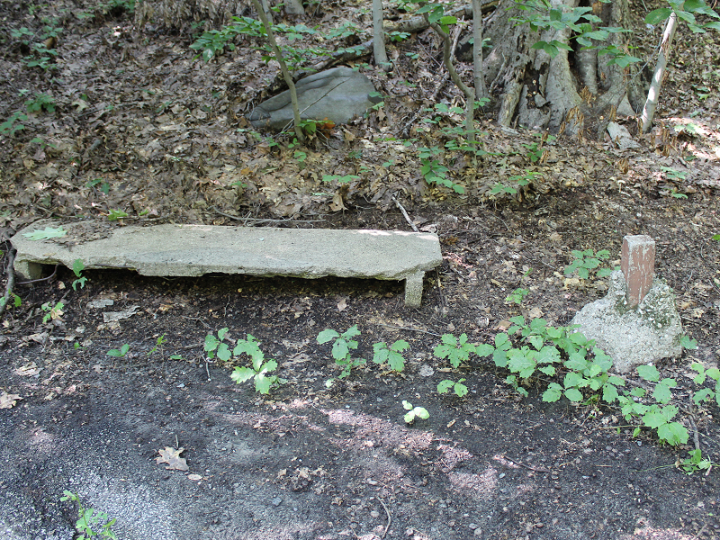
I am not sure. There has never been anything about the history of what had been a bench on a path that lay above the Bronx River. Moreover, there are numerous wooden benches just like that trunk portion in various parts of the Garden. I’m sorry that I don’t know more.
-
Tranquil and mainly dry weather will continue through much of next week. Some light rain is possible late Wednesday into Thursday, but the recent guidance has become even less impressed with the precipitation potential. Despite a cooler than normal first 7-10 days, September will likely feature near normal to somewhat warmer than normal temperatures in much of the region. The second half of the month could feature some much above normal temperatures. Fall 2021 will likely be wetter to much wetter than normal in the northern Middle Atlantic region. Since 1869, there have been 9 August cases where New York City picked up 20.00" or more rainfall during the summer. Two thirds of those cases (and 4/5 of those with summer mean temperatures of 73.0° or above) had 17.00" or more fall precipitation in New York City. 2011 is probably the closest match in terms of precipitation and a nearly identical summer mean temperature. Mean fall precipitation for those 9 cases was 14.86". The median was 17.35". The 1991-2020 normal value is 12.27". The ENSO Region 1+2 anomaly was 0.0°C and the Region 3.4 anomaly was -0.3°C for the week centered around August 25. For the past six weeks, the ENSO Region 1+2 anomaly has averaged +0.35°C and the ENSO Region 3.4 anomaly has averaged -0.47°C. Neutral ENSO conditions will likely prevail into at least mid-September. Afterward, La Niña conditions could begin to develop. The SOI was +17.83 today. The preliminary Arctic Oscillation (AO) figure was -0.343 today. On September 2 the MJO was in Phase 2 at an amplitude of 0.801 (RMM). The September 1-adjusted amplitude was 0.894 (RMM).
-
Occasional Thoughts on Climate Change
donsutherland1 replied to donsutherland1's topic in Climate Change
I did see about that oil leak. Companies should be required to pay the full costs of remediation and to continuously monitor all of their infrastructure as long as it exists. Their obligations don’t end simply when they abandon their infrastructure. Indeed, at the end of the pipeline’s useful life, the source should have been plugged and the pipe removed. All of this may well be expensive, but society should not wind up covering these costs. Society didn’t install the infrastructure. -
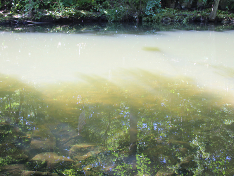
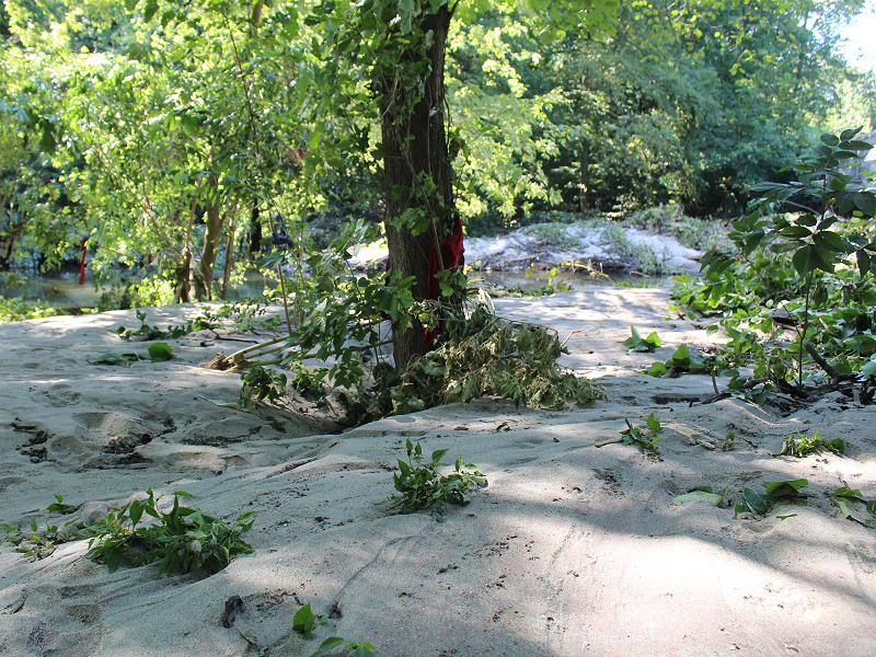
Some photos from the New York Botanical Garden following major flooding along the Bronx River. The River is filled with mud. A large amount of sand was deposited along its banks. A large bench was ripped from its foundation along a path that is still closed to the public.


-
Due to the flood damage, the Mamaroneck School District has delayed the start of school until September 13.
-
Morning thoughts… Today will be partly to mostly sunny and unseasonably cool. High temperatures will likely reach the middle and upper 70s in most of the region. Likely high temperatures around the region include: New York City (Central Park): 77° Newark: 82° Philadelphia: 79° Normals: New York City: 30-Year: 80.1°; 15-Year: 80.2° Newark: 30-Year: 81.6°; 15-Year: 81.7° Philadelphia: 30-Year: 82.7°; 15-Year: 82.6° A slow warmup could commence next week.
-
An IMF working paper estimated that after-tax externalities from the fossil fuel industry come to more than $640 billion each year in the United States. Society bears the burden of those costs. Put another way, this industry is the tobacco-asbestos-opioids industries on steroids without any of the liability for its harm. This is the ultimate “free rider” problem and it severely distorts market function. If the industry paid even 20% of the costs of its externalities to fund mitigation, adaptation, and disaster recovery, the energy industry would look very different. These companies, being self- interested and seeking profits, would have led the way to cleaner energy, as business-as-usual would have become largely or wholly unprofitable.
-
Occasional Thoughts on Climate Change
donsutherland1 replied to donsutherland1's topic in Climate Change
Both outcomes are on the climate models. What was unexpected in the West was that the air holds less moisture despite the warming. The possibility exists that heat and drought are feeding back there in a self-reinforcing cycle to an extent that there’s less moisture available. The expansion of the Hadley cell has shifted storm tracks northward. That and the greater moisture content in the warmer air has produced an increase in annual precipitation and excessive rainfall events here. In NYC, all 8 years with 60” or more of rain have occurred after 1970. None occurred 1869-1970. A disproportionate share of very wet years throughout the Northeast has occurred in 2000 or later. -
Abundant sunshine and cool temperatures will continue through the weekend. Warmer weather could return next week. Parts of the region might also have a shot at one or two light rainfall events next week. To date, Central Park has received 49.16" of rain, which would rank 2021 as the 39th wettest year on record if no additional rain fell. Records go back to 1869. Despite a cooler than normal first 7-10 days, September will likely feature near normal to somewhat warmer than normal temperatures in much of the region. Fall 2021 will likely be wetter to much wetter than normal in the northern Middle Atlantic region. Since 1869, there have been 9 August cases where New York City picked up 20.00" or more rainfall during the summer. Two thirds of those cases (and 4/5 of those with summer mean temperatures of 73.0° or above) had 17.00" or more fall precipitation in New York City. 2011 is probably the closest match in terms of precipitation and a nearly identical summer mean temperature. Mean fall precipitation for those 9 cases was 14.86". The median was 17.35". The 1991-2020 normal value is 12.27". The ENSO Region 1+2 anomaly was 0.0°C and the Region 3.4 anomaly was -0.3°C for the week centered around August 25. For the past six weeks, the ENSO Region 1+2 anomaly has averaged +0.35°C and the ENSO Region 3.4 anomaly has averaged -0.47°C. Neutral ENSO conditions will likely prevail into at least mid-September. Afterward, La Niña conditions could begin to develop. The SOI was +9.99 today. The preliminary Arctic Oscillation (AO) figure was -0.744 today. On September 1 the MJO was in Phase 2 at an amplitude of 0.896 (RMM). The August 31-adjusted amplitude was 1.182 (RMM).


