-
Posts
23,901 -
Joined
Content Type
Profiles
Blogs
Forums
American Weather
Media Demo
Store
Gallery
Everything posted by donsutherland1
-
Yes. I think the storage capacity drops when the subscription expires.
-

january 3rd potential coastal grazer
donsutherland1 replied to forkyfork's topic in New York City Metro
The 500 mb pattern is fairly similar to that of January 22, 1954, along with similar teleconnections (AO-, NAO+, PNA+). The January 22-23, 1954 storm brought 6.4" to Washington, DC, but just 0.3" to Philadelphia and no snow to New York City. I don't think the gradient will be quite that sharp this time around, e.g., I think Philadelphia will see 2"-4", Central Park 0.5" or less and the JFK/southern Brooklyn, and Staten Island could see 0.5" to perhaps an inch. -
I suspect you'll see 1"-2".
-
Noticeably colder air is now overspreading the region. Tomorrow will be variably cloudy, breezy, and cold. A snowstorm passing to the south could bring a period of light snow. Farther south, a moderate to significant snowfall is possible in parts of the Middle Atlantic region. Snowfall estimates include: Atlantic City: 5"-10" Baltimore: 3"-6" Islip: 1"-2" New York City: 0.5" or less Newark: 0.5" or less Norfolk: 1" or less Philadelphia: 2"-4" Richmond: 3"-6" Salisbury: 5"-10" Washington, DC: 4"-8" Wilmington, DE: 3"-6" Washington, DC will likely see among its highest snowfall amounts the day following a high temperature of 63° or above (today's high temperature). The five biggest such snowfalls are: 1. 5.7", February 17, 1967 2. 4.0", March 21, 1943 3. 3.3", March 16, 2014 4. 2.5", February 11, 1955 5. 1.9", March 24, 1990 The January mark is 1.5", which was set on January 20, 1915. Should Washington, DC receive measurable snow prior to the end of today, the coming storm would mark the first time on record that January saw measurable snowfall both on the day of a 60° or above high temperature and the day after, and only the 3rd time on record. This would also be the first case when the temperature reached 63° or above. January has commenced with an AO-/PNA- pattern. That typically favors somewhat cooler than normal readings in the East. For NYC, the January 1-10, 1991-2020 mean temperature for such cases was 33.5° (normal: 34.8°). This time around, the average will be warmer, but the overall tendency toward cooler weather will occur. By mid-month, New York City's temperature anomaly could be near or even somewhat below normal. Late in the first week of January, the PNA could go positive. As that happens, the prospects for measurable snowfall could increase. Since 1990, 66% of days with 1" or more snow in New York City occurred when the PNA was positive. In addition, 81% of days with 4" or more snow occurred when the PNA was positive. The latest guidance continues to suggest that temperatures could head toward seasonal levels and then below seasonal levels as the first week of January progresses. The coldest air will likely remain confined to the Pacific Northwest, Northern Plains, and western and central Canada during that time. Afterward, the cold could press farther south into at least the northern Middle Atlantic and Ohio Valley regions. Modified Arctic air could reach the Middle Atlantic region during the second week of January. The colder pattern could last for two or perhaps three weeks before it breaks down. Thus, it could begin to break down sometime in the January 15-20 timeframe. The ENSO Region 1+2 anomaly was -1.3°C and the Region 3.4 anomaly was -1.1°C for the week centered around December 22. For the past six weeks, the ENSO Region 1+2 anomaly has averaged -1.25°C and the ENSO Region 3.4 anomaly has averaged -0.98°C. La Niña conditions will likely persist through meteorological winter. The SOI was -2.11 today. The preliminary Arctic Oscillation (AO) figure was -0.484 today. On December 31 the MJO was in Phase 7 at an amplitude of 2.044 (RMM). The December 30-adjusted amplitude was 1.887 (RMM).
-
Thank you.
-
ATTN: RJAY I am trying to renew my subscription, but keep receiving error messages. I suspect it has to do with my credit card being on file and my trying to use the updated on with a later expiration date. Please advise.
-
Error message keeps occurring when I try to pay for the subscription. Please advise, Don
-
Morning thoughts… It will be mostly cloudy and unseasonably mild today. Temperatures will fall rapidly late in the day or at night. High temperatures will likely reach mainly the middle and upper 50s in most of the region. Likely high temperatures around the region include: New York City (Central Park): 55° Newark: 58° Philadelphia: 62° A developing storm will bring a moderate snowfall to parts of the Middle Atlantic region late tonight and tomorrow. There has been a pronounced increase in snowfall amounts to the north on the overnight EPS. The differences between the 1/1 12z and 1/2 0z runs include: New York: 0% 1”; 29% 1”; Philadelphia: 4% 2”; 57% 2”; Washington, DC: 6% 4”; 63% 4”. Initial snowfall estimates include: Atlantic City: 4”-8”; Baltimore: 3”-6”; Islip: 1”-2”; New York City: 0.5” or less; Newark: 1” or less; Norfolk: 1” or less; Philadelphia: 2”-4”; Richmond: 3”-6”; Salisbury: 4”-8”; Washington, DC: 3”-6”; and, Wilmington, DE: 3”-6”
-
2022 has begun with more unseasonable warmth. But a turn toward colder weather lies ahead in the medium-range. After an warm start tomorrow, temperatures will tumble late in the day. In the South, more near record and record heat prevailed for a final day of what has been an extraordinary month-long period of exceptional warmth. Preliminary records included: Birmingham: 80° (old record: 78°, 1952) Brownsville: 89° (old record: 83°, 1955 and 1989) Corpus Christi: 92° (old record: 84°, 2006) ***Tied January Record*** Galveston: 81° (old record: 76°, 1934) ***New January Record*** Houston: 85° (old record: 81°, 1917 and 2006) ***New January Record*** Jackson: 85° (old record: 81°, 1952) ***Tied January Record*** Mobile: 79° (tied record set in 1975) Montgomery, AL: 83° (old record: 79°, 1952) ***Tied January Record*** New Orleans: 82° (old record: 81°, 2006) January has commenced with an AO-/PNA- pattern. That typically favors somewhat cooler than normal readings in the East. For NYC, the January 1-10, 1991-2020 mean temperature for such cases was 33.5° (normal: 34.8°). Late in the first week of January, the PNA could go positive. As that happens, the prospects for measurable snowfall could increase. Since 1990, 66% of days with 1" or more snow in New York City occurred when the PNA was positive. In addition, 81% of days with 4" or more snow occurred when the PNA was positive. The latest guidance suggests that temperatures could head toward seasonal levels and then below seasonal levels as the first week of January progresses. The coldest air will likely remain confined to the Pacific Northwest, Northern Plains, and western and central Canada during that time. Afterward, the cold could press farther south into at least the northern Middle Atlantic and Ohio Valley regions. The colder pattern could last for two or perhaps three weeks before it breaks down. Thus, it could begin to break down sometime in the January 15-20 timeframe. The ENSO Region 1+2 anomaly was -1.3°C and the Region 3.4 anomaly was -1.1°C for the week centered around December 22. For the past six weeks, the ENSO Region 1+2 anomaly has averaged -1.25°C and the ENSO Region 3.4 anomaly has averaged -0.98°C. La Niña conditions will likely persist through meteorological winter. The SOI was +3.82 today. The preliminary Arctic Oscillation (AO) figure was -1.338 today. On December 30 the MJO was in Phase 7 at an amplitude of 1.889 (RMM). The December 29-adjusted amplitude was 2.049 (RMM).
-
-
-
In the Northeast, both Newark and Boston saw their warmest year on record in 2021. Boston: 54.6 (old record: 54.2, 2012) Newark: 58.1 (old record: 57.9, 2012)
-
Morning thoughts... Today will be cloudy, rainy, and mild. Temperatures will likely reach the middle and even upper 50s across much of the region. Likely high temperatures include: New York City (Central Park): 54° Newark: 57° Philadelphia: 59° Tomorrow will start mild, but temperatures will fall sharply late in the day. 30-Day Verification: New York City (Central Park): Average daily forecast: 48.4° Average temperature: 48.3° Average error: 1.1° Newark: Average daily forecast: 51.2° Average temperature: 50.4° Average error: 1.6° Philadelphia: Average daily forecast: 52.5° Average temperature: 52.0° Average error: 1.6°
-
Very impressive and disconcerting.
-
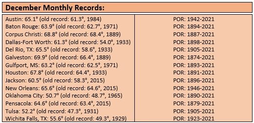
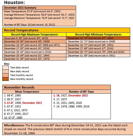
December 2021 is finishing with a monthly mean temperature of 43.8° in New York City. That was the 3rd warmest December on record. Records go back to 1869. 5 of the 10 warmest December cases have occurred since 2000. 9 of the 10 warmest December cases have occurred since 1980. 2022 will begin with more unseasonable warmth. But a turn toward cooler weather lies ahead in the medium-range. In the South, more near record and record heat prevailed. Preliminary records included: Albany, GA: 87° (old record: 81°, 1951) Baton Rouge: 84° (old record: 81°, 1974) Charleston, SC: 78° (tied record set in 1984 and tied in 1996) Charlotte: 73° (old record: 70°, 1996) College Station, TX: 83° (old record: 82°, 1951) Corpus Christi: 84° (tied record set in 2011) Galveston: 80° (old record: 74°, 1921) Houston: 84° (old record: 82°, 1974) Lake Charles, LA: 80° (old record: 78°, 1933, 1934, 1964) Meridian, MS: 84° (old record: 79°, 1951) Mobile: 81° (old record: 78°, 1988) Montgomery, AL: 83° (old record: 81°, 1951) New Orleans: 83° (old record: 81°, 1971) Pensacola: 79° (old record: 77°, 1971 and 1996) Raleigh: 74° (old record:P 72°, 1929) Savannah: 81° (old record: 80°, 1973 and 2015) Shreveport: 81° (tied record set in 1951 and tied in 1964) Tampa: 83° (tied record set in 2006 and tied in 2015 and 2018) In addition, Houston recorded its 18th 80° day of this month. The old December record was 10 days, which was set in 2012. The 18 days also matches the November record that was set in 1927. Houston also recorded its December record 8th consecutive 80° day. The old record of 5 consecutive days was set during December 3-7, 1998 and tied during December 24-28, 2016. Houston concluded December with a monthly mean temperature of 67.8°. That demolished the longstanding December mark of 64.4° from 1933. It was also high enough to tie 1909's November average, which was the 3rd warmest November on record. January will very likely commence with an AO-/PNA- pattern. That typically favors somewhat cooler than normal readings in the East. For NYC, the January 1-10, 1991-2020 mean temperature for such cases was 33.5° (normal: 34.8°). Late in the first week of January, the PNA could go positive. As that happens, the prospects for measurable snowfall could increase. Since 1990, 66% of days with 1" or more snow in New York City occurred when the PNA was positive. In addition, 81% of days with 4" or more snow occurred when the PNA was positive. The latest guidance suggests that temperatures could head toward seasonal levels and then below seasonal levels as the first week of January progresses. The coldest air will likely remain confined to the Pacific Northwest, Northern Plains, and western and central Canada during that time. Afterward, the cold could press farther south into at least the northern Middle Atlantic and Ohio Valley regions. The colder pattern could last for two or perhaps three weeks before it breaks down. Thus, it could begin to break down sometime in the January 15-20 timeframe. The ENSO Region 1+2 anomaly was -1.3°C and the Region 3.4 anomaly was -1.1°C for the week centered around December 22. For the past six weeks, the ENSO Region 1+2 anomaly has averaged -1.25°C and the ENSO Region 3.4 anomaly has averaged -0.98°C. La Niña conditions will likely persist through meteorological winter. The SOI was +16.19 today. The preliminary Arctic Oscillation (AO) figure was -1.516 today. On December 29 the MJO was in Phase 7 at an amplitude of 2.052 (RMM). The December 28-adjusted amplitude was 2.308 (RMM).
-
-
-
Realistically, if the latest guidance is taken at face value, it would last about two weeks or so. The Arctic Low pattern is shown redeveloping in late January.
-
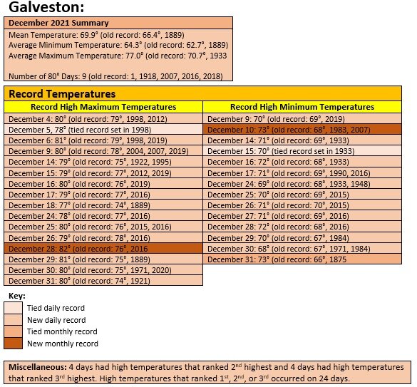
Record highs are again tumbling in the South. As of 12 pm EST, Baton Rouge, Galveston, and Pensacola have all set daily record high temperatures. Galveston has had 15 daily record highs and 1 record-tying high. One of those high temperatures set a new December record. 24 of December’s 31 days saw their 1st, 2nd, or 3rd warmest high temperatures for those days.
-
Some of the guidance is showing that an Alaskan Ridge regime could develop for a time in coming weeks. That typically affords more opportunity for cold. https://agupubs.onlinelibrary.wiley.com/doi/10.1029/2019GL085592 The PNA could also go positive late in the first week of January. So, January is looking better than December has been. It might not be severely cold or extremely snowy, but it should be colder and snowier than this December has been.
-
Not all of Florida. Pensacola is having its warmest December on record.
-

January 2022 temperature forecast contest
donsutherland1 replied to Roger Smith's topic in Weather Forecasting and Discussion
DCA _ NYC _ BOS __ ORD _ ATL _ IAH ___ DEN _ PHX _ SEA 0.6 0.4 -0.1 -2.6 3.0 2.5 -0.5 -0.3 -5.0 -
Morning thoughts… It will be mostly cloudy with some showers today. It will be unseasonably mild. High temperatures will likely reach mainly the lower and middle 50s in most of the region. Likely high temperatures around the region include: New York City (Central Park): 52° Newark: 55° Philadelphia: 57° Normals: New York City: 30-Year: 40.7°; 15-Year: 41.7° Newark: 30-Year: 41.2°; 15-Year: 42.4° Philadelphia: 30-Year: 42.5°; 15-Year: 43.6° 2022 will begin with unseasonable warmth.
-
2021 will end with mild conditions. 2022 will begin with more unseasonable warmth. But a turn toward cooler weather lies ahead in the medium-range. In the South, more near record and record heat prevailed. Preliminary records included: Albany, GA: 84° (old record: 80°, 1984) Baton Rouge: 82° (old record: 81°, 1971 and 1984) Galveston: 80° (old record: 75°, 1971 and 2020) Greenwood, MS: 79° (old record: 77°, 1990) Jackson: 81° (old record: 80°, 1923 and 1984) Lake Charles, LA: 81° (old record: 80°, 1934 and 1964) Mobile: 82° (old record: 79°, 1971 and 1974) New Orleans: 84° (old record: 81°, 1990) Pensacola: 81° (old record: 77°, 1971, 1974, and 1996) In addition, Houston recorded its 17th 80° day of this month. The old December record was 10 days, which was set in 2012. Houston also recorded its December record 7th consecutive 80° day. The old record of 5 consecutive days was set during December 3-7, 1998 and tied during December 24-28, 2016. Houston is on track to finish with a monthly mean temperature near 67.8°. That would demolish the longstanding December mark of 64.4° from 1933. It would also be high enough to tie 1909 as the 3rd warmest November on record. January will very likely commence with an AO-/PNA- pattern. That typically favors somewhat cooler than normal readings in the East. For NYC, the January 1-10, 1991-2020 mean temperature for such cases was 33.5° (normal: 34.8°). The latest guidance suggests that temperatures could head toward seasonal levels and then below seasonal levels as the first week of January progresses. The coldest air will likely remain confined to the Pacific Northwest, Northern Plains, and western and central Canada. No severe cold is likely through at least the first week of January. Afterward, the cold could press farther south into at least the northern Middle Atlantic and Ohio Valley regions. The colder pattern could last for two or perhaps three weeks before it breaks down. Thus, it could begin to break down sometime in the January 15-20 timeframe. The ENSO Region 1+2 anomaly was -1.3°C and the Region 3.4 anomaly was -1.1°C for the week centered around December 22. For the past six weeks, the ENSO Region 1+2 anomaly has averaged -1.25°C and the ENSO Region 3.4 anomaly has averaged -0.98°C. La Niña conditions will likely persist through meteorological winter. The SOI was +15.26 today. The preliminary Arctic Oscillation (AO) figure was -1.158 today. On December 28 the MJO was in Phase 7 at an amplitude of 2.309 (RMM). The December 27-adjusted amplitude was 2.565 (RMM). Based on sensitivity analysis applied to the latest guidance, there is an implied near 100% probability that New York City will have a warmer than normal December (1991-2020 normal). December will likely finish with a mean temperature near 43.6° (4.5° above normal). That would tie 2021 with 2006 as the 4th warmest December on record.


